Tuesday, September 2, 2014

Ukraine War Rebel Control Map: September 2014 (Premium)

There are newer versions of this map available. To see them, view all Ukraine updates.

Detailed map of pro-Russian rebel control in Ukraine's eastern provinces of Donetsk and Luhansk, claimed by the breakaway Donetsk People's Republic and Lugansk People's Republic. Updated to September 1, 2014

Download PDF
buy


(Subscribe via Paypal to access all premium content online)
Russia is now being accused of directly invading eastern Ukraine, and opposition control in the region has seen major changes since our last Ukraine war map update.

This is detailed map and timeline of pro-Russian territorial control in eastern Ukraine's Donetsk and Luhansk regions, home to the claimed Donetsk People's Republic, Lugansk People's Republic, and Federation of Novorossiya. Updated to the start of September 2014.

This map report is exclusive premium content, available to paid subscribers or for individual purchase.
Buy now (US$9.99)

Premium map includes:
  • Detailed, updated map of Donetsk and Luhansk regions, showing both past and current rebel control
  • Indication of which districts and cities have had their administrations occupied by separatists
  • Timeline of changes to territorial control since July, and summary of major trends

MEMBERS CLICK HERE TO PROCEED TO ARTICLE AND MAP

NOT A MEMBER YET? SUBSCRIBE NOW!


Thursday, August 28, 2014

Latvia Joins the Eurozone (map)

This article was originally published as "Map: Which Countries Use the Euro? (Plus: This Year's New Addition)". To see newer versions of the map, view all Eurozone articles on PolGeoNow.


Map of the Eurozone (euro area), showing which countries use the euro as their currency. Includes members, pre-members (ERM II), EU non-members using the euro, and other EU countries (colorblind accessible).
The Eurozone, European Union, and other countries using the euro.
Map by Evan Centanni, from blank map by Ssolbergj. License: CC BY-SA
Premium members click here to view this article in the ad-free members area. Not a member yet? Subscribe now!

Thursday, August 21, 2014

Belarus's Quiet Flag Change

Sometimes geopolitical changes make headlines, but other times they slip quietly under the radar. Such is the case with the flag of Belarus, which was changed without fanfare (or explanation) by a government decree back in 2012. We don't want you to miss any changes to the world's list of countries and flags, so we now present a belated report on this little-known event.

Premium members click here to view this article in the ad-free members area. Not a member yet? Subscribe now!

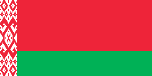
Flag of Belarus, 2012-present
Flag of Belarus, 1995-2012
Flag of Belarus, 1991-1995
By Caleb Centanni

Belarus, a former Soviet state in Eastern Europe, made a slight change to its flag in early 2012. On Feb. 10 of that year, the State Committee for the Standardization of the Republic of Belarus announced a minor change to the ornamental pattern on the left margin of the flag.

The pattern originally occupied one-twelfth of the flag's total length, and was located inside a white margin making up one-ninth of the flag design. The ornamental pattern has now been extended to fill the entire one-ninth margin. The Belarusian government apparently provided no specific reason for the change.

Other than this minor adjustment, the current flag of Belarus has been in place since 1995, when it replaced the traditional white-red-white flag after a controversial referendum that critics denounced as unconstitutional.

Belarusian President Alexander Lukashenko supported the adoption of the 1995 flag, which is very similar to the Soviet-era flag. State-owned media argued the traditional tricolor flag was unacceptable due to its use by Nazi collaborators in World War II.

Monday, August 18, 2014

Syria Civil War Map: August 2014 (#13)

There are newer versions of this map available. To see them, view all Syria updates.

Premium subscribers have already seen our new Syria map format, which shows full areas of control for each major faction in the civil war. Now, we present this month's update free of charge for your convenience. 

To get many more Syrian Civil War map updates like this one, sign up now for a premium subscription!

Map of fighting and territorial control in Syria's Civil War (Free Syrian Army rebels, Kurdish groups, Al-Nusra Front, Islamic State (ISIS/ISIL) and others), updated for August 2014. Highlights recent locations of conflict and territorial control changes.
Territorial control in the Syrian Civil War as of August 2014. Map by Evan Centanni, starting from blank map by NordNordWest. License: CC BY-SA
Premium members click here to view this article in the ad-free members area.

Threats from All Sides
Since our last Syria map update in early July, the lines of control in the civil war have not changed drastically. However, fighting on all fronts has resulted in numerous small but important changes to the situation, as the Assad government is now facing serious challenges from both the newly rebranded Islamic State (formerly ISIS/ISIL) and a loose coalition of various other rebel groups (including both the Free Syrian Army and Al-Nusra).

Sunday, August 10, 2014

Iraq Conflict Control Map: August 2014 (Premium)

There are newer versions of this map available. To see them, view all Iraq updates.

Detailed map of territorial control in Iraq in August 2014, including cities and countryside held by the Islamic State (ISIS, ISIL) and the Kurdistan Peshmerga.

Download PDF
buy


(Subscribe via Paypal to view all premium content online)
This is the latest update to our series of maps documenting territorial control in the current war in Iraq, with a number of updates since the previous edition in late June. 

It includes control by the Maliki goverment, Kurdish forces, and the Islamic State (formerly known as ISIS), and has been re-styled to fit seamlessly with our popular control maps of the Syrian Civil War.

This map and article are exclusive premium content, available only to paid members or for individual purchase. Buy now (US$9.99)

Premium map includes:
  • Up-to-date map of current territorial control in Iraq, color-coded for the Maliki government, ISIS/Islamic State extremists, and Kurdish forces
  • Detailed indication of city-by-city control, highlighting key towns relevant to current events
  • Includes recent areas of fighting including Sinjar, Qaraqosh, Mosul Dam, Erbil province, and more
  • In-depth article summarizes changes since June, including ISIS's declaration of an Islamic caliphate, with links to sources

MEMBERS CLICK HERE TO PROCEED TO ARTICLE AND MAP

NOT A MEMBER YET? SUBSCRIBE NOW!


Tuesday, July 29, 2014

African Union Reinstates Egypt and Guinea-Bissau (Map)

Map of the African Union, including active and suspended members, updated for the June 2014 reinstatement of Egypt and Guinea-Bissau (colorblind accessible).
The African Union as of July 2014. Map by Evan Centanni, from this blank map by Eric Gaba.
License: CC BY-SA
Premium members click here to view this article in the ad-free members area. Not a member yet? Subscribe now!

Thursday, July 24, 2014

Map Update: Kosovo Recognized by 3 More Countries in 2014 (106/193)

Premium members click here to view this article in the ad-free members area. Not a member yet? Subscribe now!
Map of countries that recognize the Republic of Kosovo as an independent state, updated for July 2014, with most recent additions (Togo, Tonga, Lesotho) and disputed recognitions highlighted
Countries recognizing the Republic of Kosovo in green, highlighting recent additions. Disputed recognitions in yellow. Kosovo in magenta. Map by Evan Centanni, modified from public domain graphic (source).

Tuesday, July 22, 2014

War in Ukraine: Detailed Map of Rebel Control in Donetsk & Luhansk (Premium)

etailed map of rebel control in Ukraine's eastern provinces of Donetsk and Luhansk, claimed by the breakaway Donetsk People's Republic and Lugansk People's Republic. Updated to July 22, 2014

Download PDF
buy


(Subscribe via Paypal to view all premium content online)
All new, detailed map of rebel control in eastern Ukraine's Donetsk and Luhansk regions, home to the claimed Donetsk People's Republic, Lugansk People's Republic, and Federation of Novorossiya. 

Since our last Ukraine update, pro-Russian rebels have captured much more territory in Donetsk and Luhansk regions, but also lost some of their early strongholds. 

This map report is exclusive premium content, available to paid subscribers or for individual purchase.
Buy now (US$9.99)

Premium map includes:
  • All new, detailed map of Donetsk and Luhansk regions, showing both past and current rebel control
  • Indication of which districts and cities have had their administrations occupied by separatists
  • Important locations of rebel military control marked
  • Article with chronology of events since April, and discussion of the meaning of "control"

MEMBERS CLICK HERE TO PROCEED TO ARTICLE AND MAP

NOT A MEMBER YET? SUBSCRIBE NOW!


Thursday, July 10, 2014

Map: Yemen Joins WTO

Premium members click here to view this article in the ad-free members area. Not a member yet? Subscribe now!

Map of World Trade Organization (WTO) member and observer countries, updated for July 2014 to include new member Yemen
Member and observer states of the World Trade Organization (WTO). Map by Evan Centanni, starting from public domain blank map (license: CC BY-NC-SA).

Thursday, July 3, 2014

Syria Civil War: Territorial Control Map #12.3 (Premium)

There are newer versions of this map available. To see them, view all Syria updates.

Detailed map of fighting and territorial control in Syria's Civil War (Free Syrian Army and Nusra Front rebels, Kurdish groups, ISIS/ISIL/Islamic State and others), updated to July 3, 2014.

Download PDF
buy


(Subscribe via Paypal to view all premium content online)
This is the Syria update you've been waiting for: our new map includes not only cities, but a full illustration of territorial control for each faction in the civil war. Also includes many updates to the situation since the last edition in April.

This map and article are exclusive premium content, available to paid subscribers or for individual purchase.
Buy now (US$9.99)

Premium map includes:
  • Up-to-date map of current territorial control in Syria, color-coded for the Assad government, rebel groups, ISIS/Islamic State extremists, and Kurdish self-protection forces
  • Detailed indication of city-by-city control, highlighting key towns relevant to current events
  • Includes recent areas of fighting including Deir ez-Zor, Abu Kamal, Mayadin, Khan Shaykhun, and many more
  • In-depth article summarizes changes since April, including ISIS's declaration of an Islamic caliphate, with links to the sources of information
Members click here to proceed to article and map

Not a member yet? Subscribe Now!


Tuesday, June 24, 2014

Iraq's New War: Detailed Map of ISIS Takeover (Premium)

There are newer versions of this map available. To see them, view all Iraq updates.

Detailed map of territorial control in Iraq in June 2014, including cities and countryside held by the Islamic State of Iraq and al-Sham (ISIS, ISIL) and the Kurdistan Peshmerga.

Download PDF
buy


(Subscribe via Paypal to view all premium content online)
Since our last Iraq map update less than a month ago, the conflict has blown up with a spectacularly successful offensive by ISIS rebels. PolGeoNow presents here our updated map of territorial control in Iraq, more detailed and accurate than any of the maps available on news websites.

This map and article are exclusive premium content, available only to members or for individual purchase.

 Buy now (US$9.99).


 Premium map includes:
  • Territorial control in Iraq by city, color coded for government, ISIS, or Kurdistan Government
  • Detail of ISIS control and attempted control of small towns, military bases, and border crossings
  • Inset map with extra detail for Kirkuk province, where ISIS and Kurdish forces are facing off
  • Shading showing the estimated total area of ISIS control
  • Article summarizing events since May, explaining the information on the map, and providing in-line links to sources cited
Members click here to proceed to article and map

Not a member yet? Subscribe Now!


Thursday, June 12, 2014

World Cup 2014: Which Countries Are (and Aren't) Members of FIFA?

There are newer versions of this explainer available. To see them, view all FIFA World Cup articles on PolGeoNow.

 
World map showing the six continental confederations of national association football (soccer) teams, including all teams eligible for the World Cup
The six continental confederations of national football teams associated with FIFA. Not all confederation members are individually members of FIFA. Map by Evan Centanni, based on work by EOZyo (source).
Football/soccer fans around the world are tuning in tonight for the beginning of the month-long FIFA World Cup in Brazil. But how much do you know about which teams can compete? Which countries were eligible to enter the tournament, and which are excluded? Read on for an exclusive guide to the roster of FIFA national football teams...

Premium members click here to view this article in the ad-free members area. Not a member yet? Subscribe now!

Sunday, June 8, 2014

Palestine: West Bank and Gaza Reunited Under Transitional Government

(Keep up with changes to Palestine's situation: view all Palestine updates.)

Map of the State of Palestine in the West Bank and Gaza Strip, including both its claimed borders (the Green Line) and zones of actual control (Areas A, B, and C from the Oslo Accords)
Control zones based on the Oslo Accords. Area A: Palestinian control; Area B: mixed Israeli-Palestinian control; Area C: full Israeli control. Map by Evan Centanni (sources: Natural Earth, B'Tselem, U.N. OCHA oPt).
Premium members click here to view this article in the ad-free members area. Not a member yet? Subscribe now!

By Evan Centanni

Unity Government
The partially-unrecognized State of Palestine is not only divided between Palestinian and Israel control - even the Palestinian-administered areas have been governed separately for several years now. However, this month rival parties Hamas and Fatah have finally come together to reunite the West Bank and Gaza Strip under a single Palestinian government.

Divided Country
The rift in control opened up in 2007, after religious militant group Hamas won a majority of seats in the 2006 Palestinian legislative elections. Hamas and Fatah, the current ruling party at the time, failed to form a stable unity government then, and the conflict between them escalated into a short civil war in the Gaza Strip. 

See Also: Is Palestine Really a Country?

Tuesday, May 27, 2014

Iraq: Updated Map of ISIS Control (Premium)

There are newer versions of this map available. To see them, view all Iraq updates.
 
Map of territorial control in Iraq in May 2014, including cities and countryside held by the Islamic State of Iraq and al-Sham (ISIS, ISIL) as well as areas administered by the Kurdistan Region. Includes detail of towns in flashpoint provinces of Anbar and Diyala

Download PDF
buy


(Subscribe via Paypal)
This is our first update to January's map of Al Qaeda control in Iraq. The map has been expanded to show much more detail of the ongoing campaign of control by the Islamic State of Iraq and al-Sham (ISIS), now no longer an Al Qaeda affiliate.

This map and article are exclusive premium content, available only to members or for individual purchase. Buy now (US$9.99).


 Premium map includes:
  • Territorial control in Iraq by city, color coded for government, ISIS, or Kurdistan
  • Detail of ISIS control and attempted control in small towns, including in the eastern flashpoint province of Diyala
  • Inset map with extra detail for Anbar province, where ISIS controls the most populated territory
  • Indications of estimated ISIS control/influence in the countryside
  • Article summarizing events since January, explaining the information on the map, and providing in-line links to the sources of information
Members click here to proceed to article and map

Not a member yet? Subscribe Now!


Saturday, May 3, 2014

Mayotte Enters European Union

"Outermost regions" are officially part of the European Union; "overseas countries and territories" are not part of the EU itself, but have special relations with it because of their connections to member countries. New outermost region Mayotte is located in southeastern Africa. Map from Wikimedia Commons © Alexrk2 (CC BY-SA)
Premium members click here to view this article in the ad-free members area. Not a member yet? Subscribe now!

Article by Evan Centanni

EU Expands to Include Mayotte
You probably heard about Croatia joining the European Union last year, but did you know the EU expanded further this year...in Africa? The French overseas department of Mayotte, a group of islands in the Indian Ocean northwest of Madagascar, became officially part of the EU on January 1.

Thursday, April 24, 2014

Syria Civil War Map: April 2014 (#12.2) (Premium)

There are newer versions of this map available. To see them, view all Syria updates.

Map of territorial control in Syria's civil war, updated for April 2014. Shows control by government, rebels, ISIS extremists, and Kurdish militias. Includes important sites of recent fighting such as Yabroud, Maloula, Kasab, Azaz, Morek, Al Bukamal, and more.

Download PDF
buy


(Subscribe via Paypal)
PolGeoNow's popular Syria civil war control maps are back! Here's the second of our member-exclusive premium updates. 

Developments since our previous Syria map update in January include advances by both the government and the rebels, as well as changes in territorial control for the Islamic State of Iraq and Syria (ISIS).

This map and article are exclusive premium content, available only to members or for individual purchase. Buy now (US$9.99).

Premium article includes:
  • Map of current territorial control in Syria by city, color-coded for the Assad government, rebel groups, ISIS extremists, and Kurdish militias
  • Map includes recent areas of fighting such as Yabroud, Maloula, Kasab, Azaz, Al Bukamal, and more
  • Article summarizing changes since January, with links to the sources of information
Members click here to proceed to article and map

Not a member yet? Subscribe Now!


Wednesday, April 16, 2014

Ukraine Map #3: Separatist Control in the East (Premium)

Updated map of control in Ukraine, as of April 16, 2014. Spotlight on control by separatists in the country's east, including armed takeovers and the claimed Donetsk People's Republic.

Download PDF
buy


(Subscribe via Paypal)
Since our previous Ukraine update ten days ago, there has been a spectacular resurgence of aggressive separatist activity in eastern Ukraine, including not only protester occupations but also armed seizures reminiscent of those that began the Crimea crisis last month.

This is an up-to-date and detailed map of pro-Russian rebel and protester control in Ukraine, including the self-proclaimed "Donetsk People's Republic".

This map and article are exclusive premium content, available only to members or for individual purchase. Buy now (US$5.99).

Premium article includes:
  • Ukraine control map updated for the protester occupations and armed rebel takeovers in eastern Ukraine over the past two weeks
  • Shows both protester occupations and armed takeovers, as well as which regions have declared independence
  • Includes a quick briefing on recent events, with links to the sources of information
Members click here to proceed to article and map

Not a member yet? Subscribe Now!


Tuesday, April 15, 2014

ICYMI: The Gambia's Withdrawal from the Commonwealth

"In case you missed it" - this is an article featuring news we couldn't cover when it first broke, but that we thought you might still want to know about. Those who read our article on the year 2013 in political geography changes already heard about the Gambia's withdrawal from the Commonwealth of Nations - now here's the full story.

Map of current and former member countries of the Commonwealth of Nations (British Commonwealth) as of 2014, marking the Gambia, which recently withdrew from the organization (colorblind accessible).
The Commonwealth of Nations. Current members in dark blue, former members in lavender. Map by Evan Centanni, modified from public domain blank map.
Premium members click here to view this article in the ad-free members area. Not a member yet? Subscribe now!

Saturday, April 5, 2014

Update: Ukraine Control Overview Map (Premium)

Updated map of control in Ukraine, as of April 5, 2014. Includes final protester occupations, annexation of Crimea, and areas seized by Russian and Ukrainian militaries outside of Crimea.

Download PDF
buy


(Subscribe via Paypal)
This is a brief supplement to our Mar. 4 report, Ukraine Map: Occupations, Autonomy, & Invasion. See that report for a detailed overview of protester occupations and declarations of autonomy in the first two stages of the Ukraine crisis: the anti-Yanukovich Maidan movement and the eastern pro-Russian protests. 

The current article is an update on the current control situation in Ukraine from Mar. 4 to the present. This map and article are exclusive premium content, available only to members or for individual purchase. Buy now (US$5.99).

Premium article includes:
  • Simple updated map of the political situation in Ukraine since Mar. 4
  • Shows the last of the pro-Russian protester occupations, the annexation of Crimea, and seizures by the Ukrainian and Russian militaries outside of Crimea proper
  • Report on the course of events since the last report, explaining each detail shown on the map
  • In-line links to sources of information

Members click here to proceed to article and map

Not a member yet? Subscribe Now!


Thursday, March 27, 2014

Crimea Joins Russia, Gives Up Independence, Becomes Disputed Territory

Premium members click here to view this article in the ad-free members area. Not a member yet? Subscribe now!

Map of the claimed Republic of Crimea, which briefly declared independence from Ukraine on Mar. 17 before being annexed by Russia
The claimed Republic of Crimea which has now joined Russia (click to see full-sized map). By Evan Centanni, based on this blank map.
By Evan Centanni

Russia Annexes Crimea
The Crimean peninsula, which declared independence from Ukraine ten days ago as the Republic of Crimea, has now been absorbed into Russia. This was part of the plan all along - the claimed Republic of Crimea had requested to join Russia at the same time that it declared independence.

Related: Complete Map of Locations Seized by Russia in Crimea (Premium)

Wednesday, March 26, 2014

Premium Map Report: Russian Control of Crimea

Map of Russian seizures and military actions in the Crimea region which it recently annexed from Ukraine.

Download PDF
buy


(Subscribe via Paypal)
After a month of low-level conflict, Russian military control of Crimea appears to be nearly complete. Here's a complete map - to the best of our knowledge - of all locations of Russian seizures and other military actions inside and outside of the Crimea region. This map and article are exclusive premium content, available only to members and for individual purchase. Buy now (US$4.99).

Premium article includes:
  • Exclusive map of Russian seizure and attack locations inside and outside of Crimea
  • Guide to all locations on the map, with brief summary of what has happened at each
  • In-line links to sources of information

Members click here to proceed to article and map

Not a member yet? Subscribe Now!


Tuesday, March 18, 2014

Crimea Declares Independence: Is It Really a Country?

On Monday, two regional governments on the Crimean Peninsula controversially declared their independence from Ukraine as the new Republic of Crimea. While the declaration has been rejected by most of the world community, and Crimea hopes to swiftly unite with Russia, for now it might be considered a de facto sovereign state. Read on for details.

Map of the newly declared independent Republic of Crimea, seceding from Ukraine to join Russia (colorblind accessible).
The Republic of Crimea. Map by Evan Centanni, based on this blank map.
Premium members click here to view this article in the ad-free members area. Not a member yet? Subscribe now!

By Evan Centanni

Declaration of Independence
Following Ukraine's revolution, the explosion of pro-Russian protests in the east, and the subsequent occupation of the Crimean peninsula by Russian forces (see our premium report, Ukraine Map: Occupations, Autonomy, & Invasion), a new independent country has been declared on the coast of the Black Sea.

Saturday, March 15, 2014

Madagascar Un-Suspended from African Union

Map of the African Union, including active and suspended members, updated for the January 2014 reinstatement of Madagascar (colorblind accessible).
The African Union as of March 2014. Map by Evan Centanni, from this blank map by Eric Gaba.
License: CC BY-SA
Premium members click here to view this article in the ad-free members area. Not a member yet? Subscribe now!

Saturday, March 8, 2014

How Sharply Divided is Ukraine, Really? Honest Maps of Language and Elections

There's no question that Ukraine's current crisis arose from major political divisions in the country, and it's true that language is an issue. But some online news websites have sensationalized and exaggerated these divisions through misleading maps. PolGeoNow offers a pair of maps that better communicate the blurriness of the supposed lines between western and eastern Ukraine. 

(For a map of current events from January up to this week, including protester control, government occupations, and the Russian invasion, purchase our premium map of the Ukraine crisis or become a member.)

Map of the results of Ukraine's February 2010 presidential runoff election between Yulia Tymoshenko and Viktor Yanukovich
A more honest map of Ukraine's 2010 presidential election. By Evan Centanni.
Premium members click here to view this article in the ad-free members area. Not a member yet? Subscribe now!

Article by Evan Centanni 

Misleading Ukraine Maps
In January, the Washington Post's Max Fisher wrote a popular map-illustrated blog post about the political and linguistic divisions fueling Ukraine's crisis, then at the height of its pro-Europe protest phase. Later, CNN followed the Post's lead and published a similar set of maps. However, the maps in both articles are designed in a way that makes the divisions look much sharper and more black-and-white than they really are. There's not, as Fisher preposterously claims, "an actual, physical line" splitting Ukraine in half. Instead, there's a gradual shading of mixed populations whose ethnic identities and voting history don't always correlate to the country's current political divisions.

Monday, March 3, 2014

Ukraine Map: Occupations, Autonomy, & Invasion (Premium)

Map of the 2014 Ukraine crisis, before and after the ouster of President Yanukovich, updated to March 3, 2014. Details shown include protester occupations, declarations of autonomy, and Russian invasion.

Download PDF
buy


(Subscribe via Paypal)
PolGeoNow begins our Ukraine coverage with this overview of the political situation from January to the present, both before and after the overthrow of President Viktor Yanukovich's government. Details shown include protester occupations, declarations of autonomy, and Russian invasion. This map and article are exclusive premium content, available only to members and for individual purchase. Buy now (US$5.99).

Premium article includes:
  • Exclusive map of the political situation in Ukraine's 2014 crisis
  • Shows protester occupations, regional capitals overrun, autonomy declarations, and locations of Russian military siege
  • Report on the course of events, explaining each detail shown on the map
  • In-line links to sources of information

Members click here to proceed to article and map

Not a member yet? Subscribe Now!


Saturday, February 22, 2014

South Sudan War Map: Current Rebel Control (Update #4) (Premium)

Map of rebel control in South Sudan's ongoing rebellion, showing situation at the time of the ceasefire of January 23, 2014

Download PDF
buy


(Subscribe via Paypal)
This is Part 1 of a double map report on territorial control in South Sudan's ongoing rebellion, available exclusively to premium subscribers or for individual purchase. This map shows current territorial control for late February 2014, including several changes since the time of the ceasefire. Buy now (US$3.99).

To see the map of control at the time of the ceasefire on January 23, see Part 1.

Premium article includes:
  • Exclusive map of current rebel control up to February 21, 2014
  • Multiple changes to territorial control since previous update
  • Several more new locations added to the map
  • Report chronicling changes to territorial control since the ceasefire, including links to sources

Members click here to proceed to article and map

Not a member yet? Subscribe Now!


South Sudan War Map: Control at Time of January Ceasefire (Update #3) (Premium)

Map of rebel control in South Sudan's ongoing rebellion, showing situation at the time of the ceasefire of January 23, 2014

Download PDF
buy


(Subscribe via Paypal)
This is Part 1 of a double map report on territorial control in South Sudan's ongoing rebellion, available exclusively to premium subscribers or for individual purchase. This map shows territorial control as of January 23, when the warring parties signed their ceasefire agreement (including major changes from previous update). Buy now (US$3.99).

To see the map of current control as of late February, go to Part 2.

Premium article includes:
  • Exclusive map of rebel control at the time the ceasefire was signed on January 23, 2014
  • Multiple changes to territorial control since previous update
  • Several new locations added to the map
  • Report chronicling changes to territorial control and describing the situation at the time of the ceasefire, including links to sources

Members click here to proceed to article and map

Not a member yet? Subscribe Now!


Sunday, February 16, 2014

Olympics Map Update: Which Countries Are Attending Sochi 2014?

Map of countries with teams attending the 2014 Winter Olympics in Sochi, Russia, including seven countries making their Winter Olympics debut (highlighted), and one that was suspended but reinstated during the games.
Sochi 2014: Nations attending the Winter Olympics for the first time in bright green; suspended nations reinstated during the games in blue; all other nations attending Sochi 2014 in dark green; ineligible countries/territories in gray. By Evan Centanni, from public domain base map.
Premium members click here to view this article in the ad-free members area. Not a member yet? Subscribe now!

By Evan Centanni

India's Olympics Membership Reinstated
This is a quick update to the map of countries attending the Sochi 2014 Winter Olympics, which originally appeared in Sochi 2014: Which Countries Are (and Aren't) in the Olympics? That article explained that India was not officially included in this year's games due its suspension from the International Olympic Committee (IOC) over a voting issue.

However, on Tuesday India's IOC membership was reinstated, effective immediately. This means that the three Indian athletes at the games, who were allowed to participate independently under the Olympic flag during the opening ceremony and first few days of the event, may now officially represent India again. This is the first time in history that a country has been un-suspended from the the Olympics during the actual games.

Monday, February 10, 2014

Map: Peru & Chile's Sea Dispute Settled in Court

Two weeks ago, the International Court of Justice released a long-awaited ruling on Peru and Chile's disputed maritime boundary. Many headlines claimed that Peru "won" the case, but in fact it was not a full victory for either country. Below is our detailed map of Peru and Chile's seas and of the dispute, followed by an easy-to-understand summary of the case. 

Map of Chile and Peru's territorial waters and exclusive economic zones (EEZ), plus the details of their territorial dispute at sea and disagreement of the land border. Shows the results of the Jan. 27, 2014 ruling by the International Court of Justice (ICJ) settling the dispute.
Map by Evan Centanni (country coastlines and land borders from Natural Earth)
Premium members click here to view this article in the ad-free members area. Not a member yet? Subscribe now!

Article by Evan Centanni


Disputed Territory
Chile and Peru have just settled a decades-long dispute over the location of their maritime boundary (the border between their sea zones). A large wedge of sea off the countries' coast was claimed by both sides, in part because of its high value for the fishing industry. In 2008, Peru took Chile to court over the dispute. Their disagreements would be resolved by the International Court of Justice (ICJ), a United Nations body in the Hague founded for the purpose of settling differences between U.N. member countries.

Friday, February 7, 2014

Sochi 2014: Which Countries Are (and Aren't) in the Olympics?

This is an older version of our Parade of Nations article. Click here to see the newest edition!

[This article was first published in July 2012 as "Parade of Nations: Which Countries Are (and Aren't) in the Olympics?", in connection with that year's Summer Olympics in London. The following article is an updated version for the 2014 Sochi Winter games.]

World map showing the five continental associations of National Olympic Committees, including all nations eligible for the Olympic games
The five continental associations representing the world's Olympic Nations. Gold: Pan-American Sports Organization; Green: European Olympic Committees; Black: Olympic Council of Asia; Red: Oceania National Olympic Committees; Blue: Association of National Olympic Committees of Africa; Gray: non-member country or territory. Map by Evan Centanni, starting from this blank map and modeled after this Wikipedia map.
Premium members click here to view this article in the ad-free members area. Not a member yet? Subscribe now!

The 2014 Winter Olympics in Sochi, Russia officially begin tonight (Feb. 7), and it wouldn't be an Olympic opening ceremony without the Parade of Nations. But how many countries are there in the games, and is everyone included? Read on for an exclusive guide to the roster of Olympic Nations....

Tuesday, January 28, 2014

Syria Civil War Map: January 28, 2014 (#12.1) (Premium)

There are newer versions of this map available. To see them, view all Syria updates.

Map of fighting and territorial control in Syria's Civil War (Free Syrian Army rebels, Kurdish groups, Al-Nusra Front, ISIS/ISIL and others), updated to January 28, 2014. Includes recent locations of conflict between ISIS and other rebel groups, including Raqqa, Jarabulus, Manbij, Kafranbel, and others.

Download PDF
buy


(Subscribe via Paypal)
PolGeoNow presents our first premium Syria map, part of our new more frequent updates for the Syrian Civil War! Since last month a major struggle has emerged between ISIS extremists and a coalition of other rebel groups, with several key towns changing hands. See the updated map and briefing in this premium report. Buy now (US$5.99).

Members click here to proceed to article and map

NOT A MEMBER YET? SUBSCRIBE HERE!


Sunday, January 19, 2014

ICYMI: Cape Verde's Name Change

In the following weeks, PolGeoNow will be publishing several short "in case you missed it (ICYMI)" articles on events from 2013. This is news that we weren't able to cover when it first broke, but that we thought our readers might still want to know about.

Premium members click here to view this article in the ad-free members area. Not a member yet? Subscribe now!

Topographic map of Cape Verde, now known officially as Cabo Verde
Cape Verde, now officially Cabo Verde (click to enlarge). Map by Oona Räisänen/Wikimedia (CC BY-SA) (source).
By Evan Centanni

Cape Verde Changes Official Name
If you read our article on the year 2013 in political geography changes, you've already heard about the change to Cape Verde's official English name. But since keeping track of country name changes is one of the primary missions of Political Geography Now, we are now presenting this in-depth report on the topic.

Thursday, January 16, 2014

South Sudan Rebellion: Map Update 2 (Premium Content)

Map of rebel control in South Sudan's ongoing rebellion, updated to Jan. 16, 2014

Download PDF
buy


(Subscribe via Paypal)
Both peace talks and fighting continue nearly two weeks after our last South Sudan update. In the meantime, there have been several changes to rebel control. The newly updated premium map and report reflect those events, as well as newly available information about other localities. Buy now (US$2.99).

Premium article includes:
  • Exclusive updated map of rebel control in South Sudan's ongoing uprising (current as of January 16, 2014)
  • A number of new localities have been added to the map since last time
  • Report chronicling changes to territorial control since the previous map, with links to sources

Members click here to proceed to article and map

Not a member yet? Subscribe Now!


Sunday, January 12, 2014

Iraq: Map of Al Qaeda Control

There are newer versions of this map available. To see them, view all Iraq updates.

PolGeoNow presents our first map of Iraq, showing control by the government and Al Qaeda rebels in the country's ongoing crisis. Areas of autonomous Kurdish administration in the north are also indicated.

Want to see timely updates for this map? Subscribe to our premium member service!

Map of territorial control in Iraq in January 2014, including cities and countryside held by Al Qaeda (ISIS) as well as areas administered by Kurdistan
Territorial control in Iraq at the beginning of 2014. Map by Evan Centanni, starting from this blank map by German Wikipedia user NordNordWest. License: CC BY-SA
Premium members click here to view this article in the ad-free members area. Not a member yet? Subscribe now!

By Evan Centanni


Al Qaeda in Iraq
Though the reality is of course more complex, power politics in Iraq often revolve around the country's three largest ethnic groups: Shia (Shiite) Arabs, Sunni Arabs, and Kurds (most Kurds are religiously Sunni, but their language and cultural distinguish them from Arabs). Prime Minister Nouri al-Maliki, a Shia Arab, is often accused of manipulating Iraq's democracy to exclusively serve the country's Shia majority. The Kurds govern a highly autonomous region in the northeast, but the Sunni Arabs who dominate northwestern Iraq have relatively little political power. Into the fray has jumped Al Qaeda in Iraq, now part of the Islamic State of Iraq and al-Sham (ISIS) organization which also controls parts of Syria (map). Al Qaeda has waged a fierce campaign against the Iraqi government in the name of Sunnis, though the group is still rejected by many of the people it claims to protect.

Friday, January 3, 2014

South Sudan: Rebel Control Map Update (Premium Content)

There are newer versions of this map available. To see the full list of updates, view all South Sudan articles

Map of rebel control in South Sudan's 2013-2014 political crisis, updated to Jan. 3, 2014

Download PDF
buy


(Subscribe via Paypal)
Since our first map report on rebel control in South Sudan's political crisis, the situation has continued to develop quickly, with several cities and towns changing hands. PolGeoNow now presents an updated map and report exclusively available as premium content for purchase and to our subscribers. Buy now for only US$2.99!

Premium article includes:
  • Exclusive updated map of rebel control in South Sudan's ongoing uprising 
  • Report chronicling changes since the previous map, with links to sources

Members click here to proceed to article and map

Not a member yet? Subscribe Now!