(To see other maps in this series, view all Mozambique articles on PolGeoNow.)
Map by Evan Centanni and Djordje Djukic. Timeline by Djordje Djukic, with additional reporting by Evan Centanni

After being driven from the key northeastern towns of Palma and Mocímboa da Praia by Rwandan-led forces, Mozambique's insurgents have dispersed westward as far as Meluco and Mueda districts, as well as the neighboring province of Niassa. Meanwhile, they've also increased cross-border raids into Tanzania.
See all this and more on the newest update to PolGeoNow's Mozambique
territorial control map report, which includes a timeline of changes and
important events since our previous Cabo Delgado map report at the end of last August. While the main map is focused in on Cabo Delgado province, events in Niassa province are labelled on a supplementary full-country map included in the report.
This map and report are premium content, available to paid subscribers of the PolGeoNow Conflict Mapping Service.
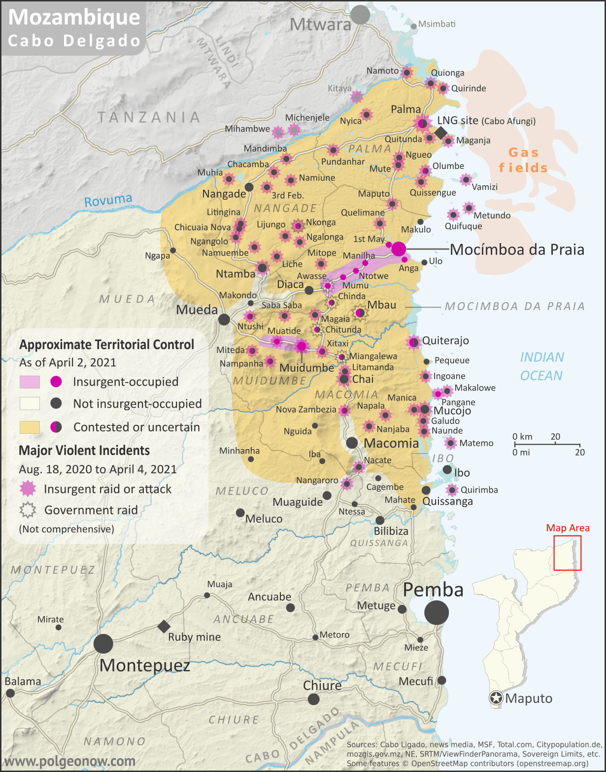
Want to see before you subscribe? Check out our most recent FREE SAMPLE Mozambique map!
Exclusive map report includes:
- Detailed illustration of approximate current territorial control in Mozambique's Cabo Delgado province, color-coded for insurgents affiliated with the so-called "Islamic State" (ISIS/ISIL) vs. the Mozambican government and allies (including Rwandan and the SADC's SAMIM troops). Colorblind accessible.
- Detailed indication of city-by-city control status, including for many relevant smaller towns and villages.
- Detailed indication of which towns and villages have subject to insurgent raids or pro-government military operations since the end of August 2021, including sites across the border in Tanzania.
- Contextual details including district boundaries, rivers, major roads, and terrain.
- Sites of international economic interest: Total's suspended LNG site, offshore natural gas fields, and Montepuez ruby mine.
- Key locations from the news, including Ngapa, Nova Zambezia, Chitoio, Quinto Congresso, Nambungali, and many more.
- Supplementary map showing the insurgency's location within Mozambique as a whole, also labeling towns in Niassa province that have come under attack, such as Mecula, Naulala, and Chimene.
- Accompanying article with detailed timeline of territorial control changes and key political and military developments since late July, with sources cited.
SUBSCRIBERS CLICK HERE TO PROCEED TO ARTICLE AND MAP
Not signed up yet? Click here to learn more about our professional subscription service!