Old Portal (members.polgeonow.com) | New Portal (controlmaps.polgeonow.com)
(To see other maps in this series, view all Ukraine articles on PolGeoNow.) 
Late 2023 and early 2024 saw small but steady gains by Russian forces across eastern Ukraine, capped by the milestone capture of Ukrainian stronghold town Avdiivka near Donetsk city. This shift in favor of Russia heralded the end of Ukraine's much-hyped 2023 counter-offensive, which had achieved disappointingly modest results.
(The maps in this report show the situation as of February 19, 2024. Territorial changes since that time, including Ukraine's surprise incursion into Russia, will be covered in a future report.)
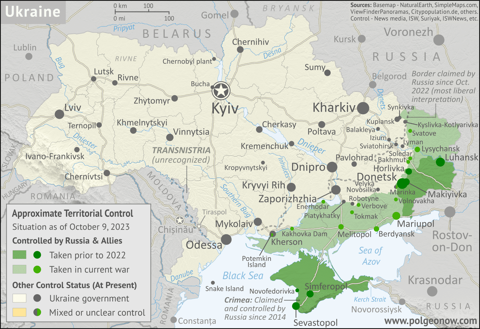
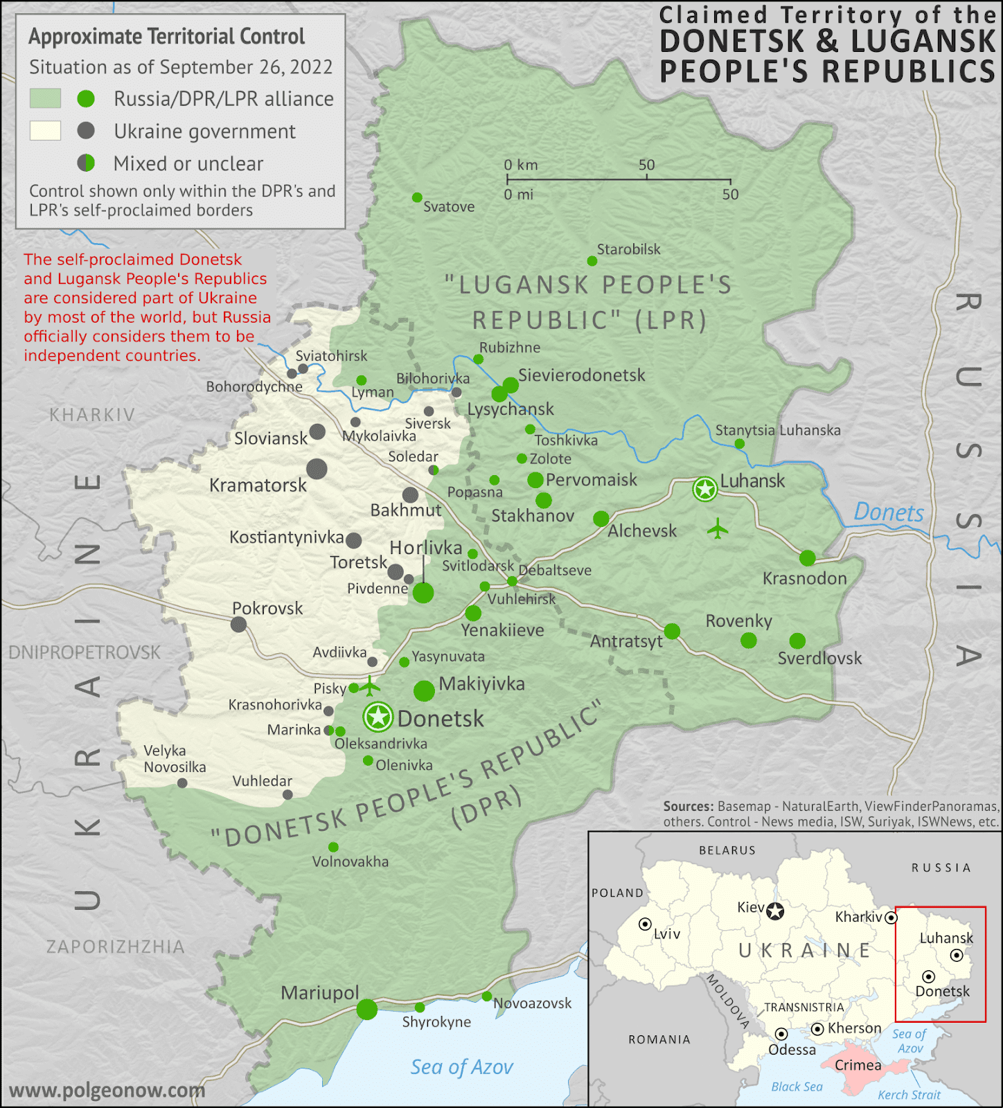
See all this and more on the latest update to PolGeoNow's concise, professional Ukraine war control map, which includes a detailed chronicle of changes and events since our previous Ukraine map report illustrating the situation in October 2023, with sources cited, as well as a close-up map of control within the claimed borders of the Donetsk and Lugansk People's Republics (which now claim to be self-governing regions inside Russia).
This map and report are premium content, available to paid subscribers of the PolGeoNow Conflict Mapping Service.
Want to see before you subscribe? Check out our most recent FREE SAMPLE Ukraine map!
Exclusive map report includes:
SUBSCRIBERS CLICK HERE TO VIEW FULL ARTICLE AND MAP:
Old Portal (members.polgeonow.com) | New Portal (controlmaps.polgeonow.com)
Not signed up yet? Click here to learn more about our professional subscription service!
Can I purchase just this map?
This map and report are not available for automated purchase to non-subscribers. If you need access or republication rights for only this map report, contact service@polgeonow.com for options.
This map and report are premium content, available to paid subscribers of the PolGeoNow Conflict Mapping Service.
Want to see before you subscribe? Check out our most recent FREE SAMPLE Ukraine map!
Exclusive map report includes:
- Illustration of current territorial control in Ukraine in February 2024, color-coded for the Ukrainian government on one side and the Russian military and allied forces on the other side, with areas of uncertainty indicated. Colorblind accessible.
- Darker color indicating which areas were already under Russian or allied control before the 2022 invasion began
- Lines showing Russia's claimed border after its annexations of Donetsk, Luhansk, Zaporizhzhia, and Kherson provinces.
Close-up map of territorial control within the self-proclaimed boundaries of the Donetsk People's Republic and Lugansk People's Republic, which now claim to be part of Russia
Donbas close-up map - Detailed indication of city-by-city control, including key towns and other locations important to current events
- Locations of recent control changes and other important events, including Avdiivka, Marinka, Krynky, Terny, Pischane, Novomykhailivka, and more
- Detailed timeline of important events and changes to territorial control from October 9, 2023 to February 19, 2024, with links to sources.
SUBSCRIBERS CLICK HERE TO VIEW FULL ARTICLE AND MAP:
Old Portal (members.polgeonow.com) | New Portal (controlmaps.polgeonow.com)
Not signed up yet? Click here to learn more about our professional subscription service!
Can I purchase just this map?
This map and report are not available for automated purchase to non-subscribers. If you need access or republication rights for only this map report, contact service@polgeonow.com for options.