![]() |
Map by Evan Centanni, from blank map by Ssolbergj. License: CC BY-SA |
Thursday, April 20, 2023
Map: Which Countries are in the European Union in 2023, Which Aren't, and Which Want to Join?
Wednesday, February 16, 2022
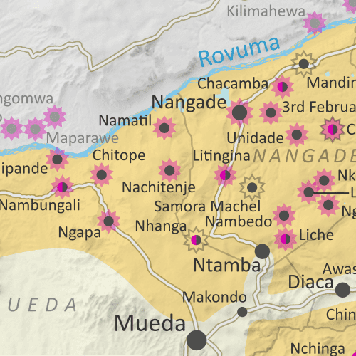
Mozambique Control Map: Cabo Delgado Insurgency Shifts West - February 2022 (Subscription)
(To see other maps in this series, view all Mozambique articles on PolGeoNow.)
Map by Evan Centanni and Djordje Djukic. Timeline by Djordje Djukic, with additional reporting by Evan Centanni
This map and report are premium content, available to paid subscribers of the PolGeoNow Conflict Mapping Service.
Want to see before you subscribe? Check out our most recent FREE SAMPLE Mozambique map!
Exclusive map report includes:
- Detailed illustration of approximate current territorial control in Mozambique's Cabo Delgado province, color-coded for insurgents affiliated with the so-called "Islamic State" (ISIS/ISIL) vs. the Mozambican government and allies (including Rwandan and the SADC's SAMIM troops). Colorblind accessible.
- Detailed indication of city-by-city control status, including for many relevant smaller towns and villages.
- Detailed indication of which towns and villages have subject to insurgent raids or pro-government military operations since the end of August 2021, including sites across the border in Tanzania.
- Contextual details including district boundaries, rivers, major roads, and terrain.
- Sites of international economic interest: Total's suspended LNG site, offshore natural gas fields, and Montepuez ruby mine.
- Key locations from the news, including Ngapa, Nova Zambezia, Chitoio, Quinto Congresso, Nambungali, and many more.
- Supplementary map showing the insurgency's location within Mozambique as a whole, also labeling towns in Niassa province that have come under attack, such as Mecula, Naulala, and Chimene.
- Accompanying article with detailed timeline of territorial control changes and key political and military developments since late July, with sources cited.
SUBSCRIBERS CLICK HERE TO PROCEED TO ARTICLE AND MAP
Not signed up yet? Click here to learn more about our professional subscription service!
Tuesday, January 25, 2022
Ethiopia War Map: Tigray Rebel Advance on Capital & Control Today (Nov. 2021/Jan. 2022)
(There are newer versions of this map available. To see them, view all Ethiopia articles on PolGeoNow.)
As a followup to the three Tigray war maps we've published as guest features from Daniel of Passport Party, PolGeoNow is pleased to present our new in-house map of control in Ethiopia's ongoing civil war. The new map shows Tigray rebel control both today and at its greatest extent last November, while also highlighting a second insurgency by allied rebel group the Oromo Liberation Army.
![]() |
Map by Evan Centanni and Djordje Djukic. Terrain data sourced from ViewFinderPanoramas.
Contact us for permission to use this map. |
Timeline by Djordje Djukic, with additional reporting by Evan Centanni
Rebel Advance on Addis Ababa - and Subsequent Retreat
In the five months since our previous report on Ethiopia's civil war, Tigray rebels expanded their control far south of their home state's borders, nearly reaching the national capital city of Addis Ababa. However, despite assistance from another Ethiopian rebel group, their gains were eventually reversed, with Ethiopian federal government forces and allies pushing them back within the boundaries of Tigray state. Now, the situation has almost returned to the same place it was when the war began, with Tigray largely controlled by rebels associated with its former state government, while neighboring Amhara state controls its own territory plus a section of western Tigray.
Wednesday, October 13, 2021
Somalia v. Kenya: 3 Maps Explaining the Maritime Dispute & Court Ruling
![]() |
Scroll down for the full-size maps |
The UN's main court for disputes between countries, the International Court of Justice (ICJ), ruled yesterday on a contentious case many years in the making: Kenya and Somalia's dispute over the rights to a large slice of the Indian Ocean off their coasts.
While other news outlets analyze the politics and economics of the dispute, it's PolGeoNow's job to give you a clearer, more detailed explanation of its geography. And as shown in the three all-new map infographics below, that geography is a bit more complex than most news articles let on.
Scroll down to see each map at full size, along with concise explanations expanding on the information within the graphics...
Tuesday, July 20, 2021
Central African Republic Control Map & Timeline - July 2021
There are newer versions of this map available. To see them, view all Central African Republic articles on PolGeoNow.
We've revived and relaunched our coverage of territorial control in the Central African Republic, one of PolGeoNow's original areas of reporting from back in 2013. The timeline in this article covers the entire period from then up to now, and going forward, our newly-redesigned map will be updated as needed. To ensure your access to future updates, sign up for our conflict mapping service.
![]() |
Map by Evan Centanni and Djordje Djukic. Terrain data sourced from ViewFinderPanoramas. Contact us for permission to use this map. |
(Subscribers click here to view this article in the member area)
Timeline by Djordje Djukic and Evan Centanni
Who controls the Central African Republic in 2021?
Since PolGeoNow's last coverage of rebel control in the Central African Republic back in 2013, the country's civil war has continued all the way until today, but with some major reconfigurations. The Séléka rebel coalition, officially disbanded after it took over the country's government in 2013, has undergone a long series of fragmentations and reconstitutions since stepping down from full control of the country in 2014. Perhaps more surprisingly, many of the ex-Séléka groups have teamed up with their once-bitter enemies - militias of the Anti-balaka movement - to form a unified front against the country's internationally-backed government, which sees both of them as unwelcome rogue elements.
Friday, May 14, 2021
Israel / Palestine Map: Who Controls What in May 2021?
This article was originally published in July 2020, but has been revised and updated to May 2021. The accompanying map has also been revised for clarity, but there have been no changes to territorial control since the previous edition.
![]() |
Click to enlarge. Map by Evan Centanni, incorporating base map by Koen Adams of onestopmap.com and data from B'Tselem's interactive mapping project. (Contact us for permission to use this map.)
|
(Subscribers click here to view this article in the members area)
Israel and Palestine Controlled Areas
The Israeli government's much-hyped plan to annex (absorb) parts of the Palestine-claimed West Bank into Israel last July never came to pass, but the region is once again making headlines amid a new wave of fighting. So who actually controls what parts of Palestine and Israel's claimed territories? This newly-revised version of PolGeoNow's Israel/Palestine control map lays out the details of government jurisdictions on the ground. And if you see something you don't understand on the map, check below for our concise outline of the disputed regions and conflict actors involved, which has also been updated and slightly expanded since first published last year.Note that this is a map of who actually controls what, not of who claims which areas. And it's definitely not supposed to imply that any particular party should or shouldn't control any particular area. As always, PolGeoNow takes no side in these disputes, and we have done our best to report only the facts.
Thursday, April 22, 2021
Mozambique Insurgency: Close-up Map of Control in April 2021
There are newer editions of this map available. To see them, view all Mozambique articles on PolGeoNow.
It's finally here: the close-up, super-detailed version of our Mozambique insurgency control map! This edition depicts the situation near the beginning of this month, when the government was fighting for control of Palma. A new close-up version of our August 2020 map is also now available, and future updates are expected more frequently from now on. To see the full list of reports, you can always view all Mozambique articles on PolGeoNow.
Map by Evan Centanni and Djordje Djukic. Some elements © OpenStreetMap contributors. Terrain data sourced from ViewFinderPanoramas. Contact us for permission to use this map.
|
Timeline by Djordje Djukic and Evan Centanni
New: Close-up Cabo Delgado Insurgency Map
In the eight months since our first Mozambique conflict timeline was published, insurgents in Cabo Delgado province have gradually increased their control, continuing to raid villages and towns in multiple districts, culminating most recently in their temporary takeover of most of Palma, a major town close to under-construction natural gas facilities operated by French company Total. The rebel group - locally known as "Al Shabaab" but thought to formally label itself Ahlu Sunnah Wa-Jamâ (ASWJ) - is increasingly believed to be cooperating, if only loosely, with the so-called "Islamic State" (IS; ISIS/ISIL).
Now, for the first time, PolGeoNow presents our close-up map of the Cabo
Delgado conflict, rigorously researched and edited to provide the most
detailed, informative, and reliable map of insurgent control and attacks
available anywhere.
Monday, August 17, 2020
"Islamic State" in Mozambique? Control Map & Timeline of the Insurgency
There are newer editions of this map available. To see them, view all Mozambique articles on PolGeoNow.
This is the first edition of our new Mozambique control map series. To guarantee your access to future updates, sign up our conflict map subscription service (updates may be released for free if changes end up being very few or far between).
![]() |
Map by Evan Centanni and Djordje Djukic. Contact us for permission to use this map. Terrain data sourced from ViewFinderPanoramas.
|
Article by Evan Centanni and Djordje Djukic
Northern Mozambique's Insurgency: What We Do and Don't Know
![]() |
Close-up version of the above map, with expanded timeline (subscriber exclusive; click for more info). |
At PolGeoNow, researcher Djordje Djukic has been keeping an eye on this conflict for some time, and we're now pleased to present what we believe to be the world's first map series documenting territorial control in the northern Mozambique insurgency.
Update: A much more detailed close-up version of the above map, adding insurgent raids and accompanied by an expanded timeline, is now available to our paid subscribers.
Thursday, July 16, 2020
Which Countries Use the Euro in 2020? (Map of the Eurozone)
Editor's Note: As of January 2023, the Eurozone now includes Croatia. The map and article below will soon be updated to reflect this.
This Eurozone map and explainer article have been updated to July 2020. The article was originally published in June 2016, and the earliest version of the map appeared in a 2014 news article.
![]() |
The Eurozone, European Union, and other countries using the euro. Map by Evan Centanni, from blank map by Ssolbergj. License: CC BY-SA |
Article by Caleb Centanni, with additional content by Evan Centanni
What is the Eurozone?
Officially called the "euro area", the Eurozone is a nickname for the group of countries in Europe that share a single currency, called the euro. The euro currency is administered by the European Union (EU), but many countries in the EU don't use the euro, and some countries outside the EU do use it. The European Central Bank, the governing financial body of the Eurozone, is headquartered in Frankfurt, Germany. Germany, along with eleven other EU countries, became a founding member of the Eurozone in 1999.Wednesday, July 1, 2020
Israel / Palestine Map: Who Controls What in 2020?
This is the original version of PolGeoNow's Israel/Palestine administrative control map, as published in July 2020. An improved version is now available as of May 2021 (there have been no changes to the lines of control).
![]() |
Click to enlarge. Map by Evan Centanni, incorporating base map by Koen Adams of onestopmap.com and data from B'Tselem's interactive mapping project. (Contact us for permission to use this map.)
|
The explanatory article accompanying this map has been revised and updated, and can now be found at the following link: Israel / Palestine Map: Who Controls What in May 2021?
Tuesday, April 14, 2020
Schengen Border Controls in the Time of Coronavirus (April 14, 2020)
Since 2016, PolGeoNow has mapped reinstated border controls within Europe's Schengen free travel area, with the companion piece to this article covering changes from mid-2017 up to last month. Now, border controls between European countries have drastically expanded amid the global coronavirus pandemic.
Read on for a country-by-country list of border controls and travel bans, plus a timeline of what went into effect when.
![]() |
Map by Evan Centanni, from blank map by Ssolbergj. License: CC BY-SA |
Coronavirus-related Border Checks in the Schengen Area
As many travelers know, much of Europe is linked together as part of the "Schengen Area", a collection of countries that don't make travelers show any ID to cross the borders between them, and don't regulate what people bring across with them either (although this system is overseen by the European Union, the Schengen Area and the EU aren't the same thing). But under special circumstances, member countries can choose to temporarily resume border checks (also known as "border control").Friday, March 27, 2020
Schengen Border Controls in the Time of Coronavirus (March 27, 2020)
![]() |
Map by Evan Centanni, from blank map by Ssolbergj. License: CC BY-SA |
Coronavirus: Schengen Border Controls Timeline March 1-27, 2020
Border controls have proliferated within Europe's "Schengen Area", where there's normally no ID check required to travel from one country to another. For more details, and to see a current map and list country-by-country list of official controls, visit our updated Coronavirus Schengen Border Controls article. Continue reading this article for the timeline of changes to official border controls from the beginning of the COVID-19 outbreak through March 27, as preserved from the previous edition of the article.Map of the Schengen Area, Europe's Border-free Travel Zone
Editor's Note: As of January 2023, the Schengen Area now includes Croatia. The map and article below will soon be updated to reflect this.
What is the "Schengen Area"? What's the difference between Schengen and the EU? And which countries does Schengen include? Read on for all the answers, explained in plain English!
Important note: Though borders within the Schengen Area are normally completely open, countries can sometimes bring back temporary (or even long-term) ID checks. You can check for recent maps of the situation by viewing all Schengen border control articles on PolGeoNow. This is especially true during the 2020 global coronavirus pandemic, when many countries have not only brought back border controls, but are also turning away foreign travelers.
![]() |
Map by Evan Centanni, from blank map by Ssolbergj. License: CC BY-SA |
Friday, February 7, 2020
Map: Which Countries were in the European Union in 2020, Which Weren't, and Which Wanted to Join?
There are newer versions of this article and map available. You can always find the latest version at this link: Which Countries are in the European Union?
The UK has finally officially left the European Union (EU), almost four years after its famous "Brexit" vote, and taken the British territory of Gibraltar out with it. Here's our updated map and list of which countries are in the EU, which ones are trying to join, and which European countries are in neither group.
![]() |
The European Union after the January 2020 departure of the UK and Gibraltar (pre-Brexit version here). Map by Evan Centanni, from blank map by Ssolbergj. License: CC BY-SA |
Monday, August 26, 2019
Map: What is the African Continental Free Trade Area (AfCFTA)?
![]() |
Map by Evan Centanni, from blank map by Eric Gaba. License: CC BY-SA |
New Trade Bloc: What is the AfCFTA Agreement?
Despite being neighbors, most countries in Africa trade more with other continents than with each other - a peculiar leftover of colonialism that the African Union (AU) has long been looking to change. Last year, the organization's member countries finally came together and agreed on the creation of one of the world's most expansive "free trade areas". The new zone, called the African Continental Free Trade Area (AfCFTA), officially came into being on May 30, 2019, after a minimum threshold of 22 countries confirmed that they had copied its 2018 founding treaty into their national laws (a process called "ratification").Thursday, March 7, 2019
2015 in Afghanistan: Map of Taliban and "Islamic State" Control
Welcome to PolGeoNow's new series of Afghanistan control maps! In the coming months, we'll publish more maps and timelines spanning the gap between 2015 and 2019, leading into routine updates of the current situation. To secure your access to all future installments, sign up now for our professional conflict map subscription service!
![]() |
Basemap by Koen Adams of onestopmap.com, with territorial control by Evan Centanni.
Contact us for permission to use this map. |
(Subscribers click here to view this article on the member site)
Timeline by Evan Centanni
Afghanistan: Who Controlled What in 2015?
The date is October 2, 2015. In the year and a half since the low point of Taliban control shown in our April 2014 Afghanistan map, the rebel group has been steadily expanding its territory. Most recently, the Taliban have launched a surprise takeover of Kunduz city, one of northern Afghanistan's major population centers, and the first provincial capital they've controlled since their national government was overthrown in 2001. Meanwhile, as the current government pours all its resources into taking the city back, the Taliban take advantage of the chaos to seize control of various other districts across the Afghan countryside.Meanwhile, the so-called "Islamic State" (IS; formerly ISIS/ISIL), based thousands of kilometers to the west in Iraq and Syria, has established a formidable new branch in Afghanistan. This IS affiliate - known officially as "Khorasan Province" - has carved out a small territory of its own in Nangarhar, along the border with Pakistan, and is now reaching what will be the height of its power in Afghanistan. Though both IS and the Taliban are religious hardliners, IS's brutal tactics, largely foreign membership, and claimed superiority have made it an enemy of the Taliban, and left it with very little support among the Afghan people.
Thursday, November 29, 2018
Afghanistan: Map of Taliban Control in April 2014
Welcome to PolGeoNow's brand new series of Afghanistan control maps! In the coming months, we'll publish more maps spanning the gap between 2014 and 2018, leading into routine updates of the current situation. To secure your access to all future installments, sign up now for our professional conflict map subscription service!
![]() |
Basemap by Koen Adams of onestopmap.com, with territorial control by Evan Centanni.
This map has been slightly revised. You can see the original here. Contact us for permission to use this map. |
Article by Evan Centanni
Afghanistan: Who Controlled What in 2014?
The date is April 5, 2014. It's been more than 12 years since a US-led invasion helped overthrow the Taliban's Islamic Emirate of Afghanistan, a religious hardline government that ruled most of the mountainous country from 1996 to 2001. Its successor, the NATO-backed Islamic Republic of Afghanistan, is voting today on a replacement for President Hamid Karzai, who has led the country ever since the Taliban government's fall in 2001.Friday, September 28, 2018
"Macedonia": Why is a Name So Important?
![]() | |
Ancient definitions of Macedonia compared with modern borders. Contact us for permission to use this map. |
What's in a Name? The "Macedonia" Dispute
This Sunday, Southeastern Europe's Republic of Macedonia is voting on a deal with Greece that includes changing its name to "Republic of North Macedonia". Greece objects to its neighbor using the name "Macedonia", and has been locked in a bitter dispute over it ever since the smaller country declared independence from Yugoslavia in 1991.The spat is serious enough that the Republic of Macedonia has been forced to accept the temporary name "former Yugoslav Republic of Macedonia" (FYROM) in the UN and other international organizations for the past 25 years, and has been blocked entirely from joining the European Union and NATO, where Greece holds veto power on new member applications.
Friday, July 20, 2018
Libyan Civil War Map & Timeline - July 2018
![]() |
Base map by Koen Adams of onestopmap.com, with territorial control by Evan Centanni and Djordje Djukic. All rights reserved.
|
(Subscribers click here to view this article on the member site)
Timeline by Djordje Djukic
Libya: Who Controls What?
Ten months after our previous Libya control map and report, the country remains divided between two major rival governments and several smaller groups, but there have been a few changes to their areas of control. This is the first free edition of our map that also shows the territories of the Toubou and Tuareg militias in Libya's south, which align on and off with the country's two major governments.Saturday, February 3, 2018
Map: Costa Rica & Nicaragua Settle Border Dispute in Court
![]() |
Map by Evan Centanni, based on materials submitted to the court. Contact for usage permissions. |