(To see other maps in this series, view all Somalia updates.)
This is the second of a set of three Somalia reports published in June 2025 covering the past two years of Somalia's civil war, here mapping the situation as of late June 2024. See also our simultaneously-published reports illustrating the situation as of August 2023 and June 2025.
To access our full catalog of map reports covering control in Somalia and many other countries, sign up for our Control Map Subscription Service
– popular with major government and international organizations, but
available to individual subscribers at just US$19.99 per month!
|
Base map by Koen Adams of onestopmap.com, with design and control by Evan Centanni. To use this map in your own materials, please contact us to arrange permission.
|
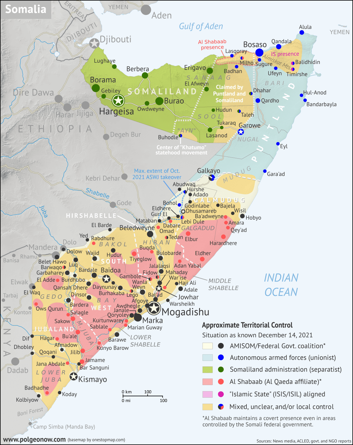
Mapping Somalia in 2024: Al Shabaab Stalemate and the Height of ISIS Control
This report covers the period in Somalia’s civil war from August 26, 2023 to June 28, 2024, before the events of early 2025, which would see a major Al Shabaab resurgence in central Somalia, as well as the retreat of the so-called “Islamic State” (IS, formerly ISIS/ISIL) during Puntland state’s “Operation Lightning’” (Hilaac) in the remote mountains of the north. In retrospect, the time from mid-2023 to mid-2024 now looks like a period of relative calm – particularly as the war between Somaliland and SSC-Khatumo settled into a state of frozen conflict - but there were still a number of important developments, which are summarized in the following paragraphs and covered in more detail in the event timeline further below (where additional sources are cited in the form of in-line links). In brief, this period included:
- The rollback of recent pro-federal gains in central Somalia's Galgadud region after the coalition's defeat at Osweyne, returning Al Shabaab’s area of control there to its previous extent from 2022 (including Elbur and, for a time, Eldher as well)
- Federal-aligned forces’ temporary capture, lasting for several months, of the most prominent settlements held by Al Shabaab in neighboring Mudug region (Ba’adweyn, Amara, and Qey’ad), and lasting control of Bulo Haji, a key outpost in Lower Juba
- The defeat of Al Shabaab in northern Somalia's Almiskat Mountains at the hands of the so-called "Islamic State" (ISIS/ISIL), which was then able to consolidate power and reach roughly its all-time peak of control in Somalia
- Progress in the planned reduction of the African Union’s ATMIS “peacekeeping” force, with the number of bases handed over or closed reaching at total of 18 out of roughly 70
- Political turmoil as the Somali federal government turned against ally Ethiopia over a deal that country struck with self-proclaimed independent Somaliland
- A major escalation in the “Hiran State” movement, with its supporters clashing with federal forces and capturing key sites in Beledweyne city
- The end of the “Ga’an Libah” insurrection in central Somaliland
- Self-governed Puntland state’s latest exit from federal politics, announcing that it would act “independent” even while continuing to say it was part of Somalia

 (To see other maps in this series,

 There are newer editions of this map available. To see them, view all