SUBSCRIBERS CLICK HERE TO VIEW FULL MAP:
Old Portal (members.polgeonow.com) | New Portal (controlmaps.polgeonow.com)
(To see other maps in this series, view all Somalia updates.)

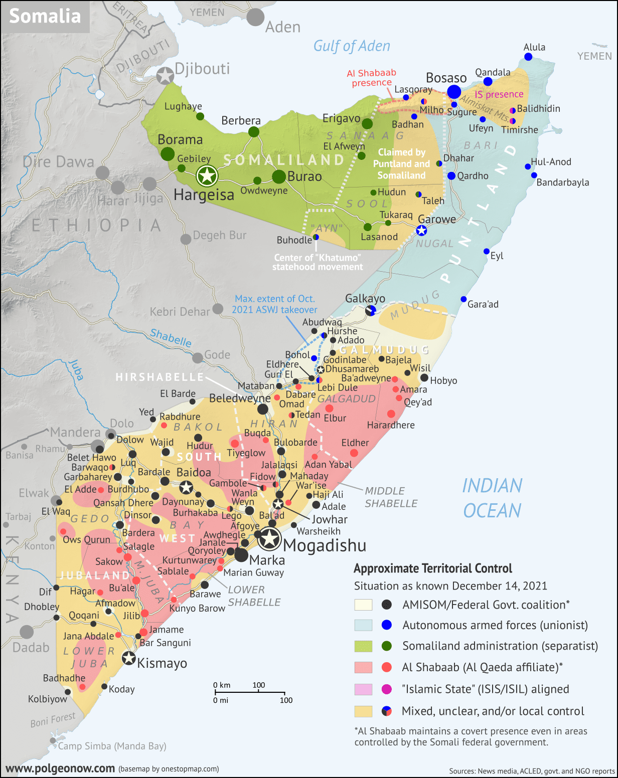
We're still midway through the process of preparing a full 2026 Somalia Control Map and Report, but subscribers who just need the map can find here a “preliminary edition” based on research up to April 15, 2026.
This map is researched and fact-checked to approximately the same high standards we apply to reports, but is missing the report itself, which would cite our sources and document what changes have occurred since our previous map report in June 2025. That documentation will be covered in the final report coming later this year, which will also update the map up to the present date at that time.
More Somalia Services
PolGeoNow is a world leader in expertise on the geographic details of conflicts in Somalia, with various government and NGO customers relying on us for rigorously-investigated maps of territorial control. The above map is created with reference to PolGeoNow's proprietary database of village-level territorial control assessments, covering the entire territory claimed by Somalia. If you have questions about the sources and rationale for specific mapping decisions, please contact our lead cartographer and we'll be happy to provide answers.
If you're in need of deeper or more detailed information than shown on the map, you can also now contact us for additional services, tailored to your budget. The following are available on a short timeline:
- Licensing of our Somalia maps for use in your own publications (can be included in custom subscriptions)
- Direct consulting on subjects like fine-grained territorial control, accurate location of events, and recent history of control for specific locations going back to 2023
- GIS data consisting of points for towns, villages, and other locations with columns for assessed territorial control at specific points in time; for areas covered by conflict reporting in recent years, this also includes added and corrected locations beyond what's found in widely-available datasets such as OCHA humanitarian info, Google Maps, and OpenStreetMap
- Place name data documenting the myriad ad-hoc spellings seen in Somali and English-language reporting, to help you quickly find locations mentioned in reporting
With greater lead time, we can also offer services such as:
- Customized map editions showing the situation on your date of choice (present or past), incorporating additions or modifications as needed for your use case
- Close-up maps showing territorial control in much more detail for specific states, regions, or areas
- Shapefile polygons for incorporation of our actual mapped lines of control into your own GIS workflow
- Mapping the locations of military bases or checkpoints used by the various conflict actors (as compiled from publicly available reporting - we do not do our own ground-truthing research or have access to confidential sources).
For any of the above services, you can directly email Evan Centanni, our lead cartographer and Somalia researcher, at evan@polgeonow.com. All Somalia-related inquiries will be read and receive a timely reply. Have another idea? Run it by us!


")


