Showing posts with label autonomous regions. Show all posts

Saturday, February 18, 2023

Somalia Control Map & Timeline: Al Shabaab in Retreat - January 2023 (Subscription) - Final Version

SUBSCRIBERS CLICK HERE TO VIEW FULL ARTICLE AND MAP:
Old Portal (members.polgeonow.com) | New Portal (controlmaps.polgeonow.com)


(To see other maps in this series, view all Somalia updates.)
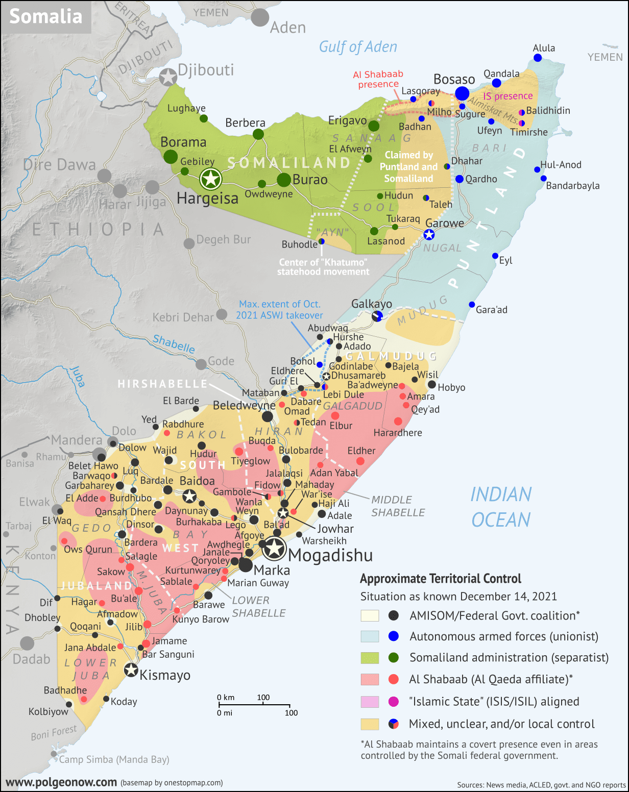

Map by onestopmap.com, Evan Centanni, and Djordje Djukic

Subscribe for full access to all conflict map reports!

Thumbnail: Who controls Somalia? Map (January 2023 - final version). With states, regions, and territorial control. Best Somalia control map online, thoroughly researched, detailed but concise. Shows territorial control by Federal Government of Somalia (FGS), Al Shabaab, so-called Islamic State (ISIS/ISIL), separatist Somaliland, autonomous state Puntland, and boundaries of additional federal member states Galmudug, Jubaland, South West, and Hirshabelle. Now labels state capitals and disputed boundaries between Somaliland and Puntland, as well as key towns from recent news, including Bo'o (Booco), Ali Gadud, Masagaway, Harardhere, Eldher, Bahdo (Baxdo), Qayib, and many more. Updated to January 17, 2023. Colorblind accessible.
Pro-federal forces, including local militias and other allies, have made remarkable gains against Al Shabaab in recent months, despite their advances in mid-2022 having been exaggerated. Al Shabaab has recently been driven out of several major towns that it governed unopposed for many years - potentially the biggest achievement of the pro-federal coalition in almost a decade.

See all this and more on the latest update to PolGeoNow's concise, professional Somalia control map, which includes a timeline of territorial changes and key events since our previous Somalia map report of December 2021, with sources cited.

This map and report are premium content, available to paid subscribers of the PolGeoNow Conflict Mapping Service.

Want to see before you subscribe? Check out our most recent FREE SAMPLE Somalia map!

Exclusive map report includes:

  • Up-to-date illustration of current territorial control in Somalia, color-coded for the federal government coalition (including ATMIS peacekeepers), autonomous unionist forces, separatist Somaliland, Al Qaeda affiliate Al Shabaab, and fighters aligned with the so-called "Islamic State" (IS; formerly ISIS/ISIL). Areas of mixed or unclear control indicated separately. Colorblind accessible.
  • Boundaries and labels for Somalia's official regions and states, including the self-proclaimed independent Republic of Somaliland and federal states Puntland, Galmudug, Jubaland, South West, and Hirshabelle. Illustrates the claims of both sides in the Somaliland-Puntland border dispute, as well as actual control.
  • Detailed indication of city-by-city control, including many relevant smaller towns and villages.
  • Locations of recent fighting and other important events, including Bo'o (Booco), Ali Gadud, Masagaway, Harardhere, Eldher, Bahdo (Baxdo), Qayib, and many more.
  • Detailed timeline of territorial control changes and key political and humanitarian developments since December 14, 2021, with sources cited. 
  • Summary of the conflict situation and changes to the map over the past four months.
  • Chronicle of the self-proclaimed Republic of Somaliland's international relations in its quest for recognition as an independent country (events included as part of timeline)

SUBSCRIBERS CLICK HERE TO VIEW FULL ARTICLE AND MAP:
Old Portal (members.polgeonow.com) | New Portal (controlmaps.polgeonow.com)


Not signed up yet? Click here to learn more about our professional subscription service!

Friday, December 17, 2021

Referendum 3 of 3: New Caledonia Won't Become Independent

Parts of this article are adapted from our 2020 New Caledonia referendum explainer, but have been revised and updated for the latest vote.

The islands of New Caledonia, and their location in the South Pacific. Map by NormanEinstein (CC BY-SA; source)
The South Pacific islands of New Caledonia voted again last weekend on whether to become independent from France, in the last of a series of three referendums. As in 2018, and again last year, the anti-independence side has won the majority of the votes.

But this time was much different. In 2018, 43% of voters chose the independence option, and in 2020 that proportion grew to 47%. But last weekend, amid calls for a boycott from pro-independence campaigners, a only a staggeringly-small 3.5% of participants voted to separate from France. Total voter turnout was barely half the amount from last year.

Why did this happen, and what now? Read on for the answers.

Tuesday, December 14, 2021

Somalia Control Map & Timeline - December 2021

There are newer versions of this map available. To see them, view all Somalia articles on PolGeoNow.

Who controls Somalia? Map (December 2021). With states, regions, and territorial control. Best Somalia control map online, thoroughly researched, detailed but concise. Shows territorial control by Federal Government of Somalia (FGS), Al Shabaab, so-called Islamic State (ISIS/ISIL), separatist Somaliland, autonomous state Puntland, and boundaries of additional federal member states Galmudug, Jubaland, South West, and Hirshabelle. Now labels state capitals and disputed boundaries between Somaliland and Puntland, as well as key towns from recent news such as Ba'adweyne, Amara, Qey'ad, Marian Guway, Balidhidhin, and more. Updated to December 14, 2021. Colorblind accessible.
Base map by Koen Adams of onestopmap.com, with territorial control by Evan Centanni and Djordje Djukic.
Contact us for permission to use this map.

(Subscribers click here to view this article in the member area)

Timeline by Evan Centanni and Djordje Djukic

Somalia Crisis Timeline: Political and Military Disarray in 2021

In the nearly 10 months since PolGeoNow's previous Somalia control map report, the country's news cycle has been dominated by a series of interconnected political crises that have led the federal government's military to the brink of civil war. All the while, the fight against Al Qaeda affiliate Al Shabaab, which operates a parallel government across much of Somalia's countryside, has continued to see a mix of victories and defeats for each side. And while the standoff between the federal army and Jubaland state forces has ended, new regional conflicts have erupted in Hirshabelle and Galmudug states, including a major resurgence of the controversial ASWJ militia.

Read on for concise summaries of the past 10 months' political crises and military trends, followed by a detailed timeline of events since February. Sources for our reporting, and for changes to the map since last time, are covered in the detailed timeline and the additional source notes at the bottom of the page.

Tuesday, August 10, 2021

Guest Feature: Map of Control in Ethiopia's Tigray Conflict (August 2021)

Update: PolGeoNow now has an in-house map showing territorial control in northern Ethiopia. To find the latest version, view all Ethiopia reports.

In a dramatic reversal, Tigray rebels are now on the offensive after recapturing their state's capital in northern Ethiopia. To illustrate the current situation, PolGeoNow is again honored to feature a territorial control map created by our colleague Daniel from Passport Party. Also included is a timeline of events since the previous update in February.

Tigray control map: Rough illustration of territorial control in Ethiopia's Tigray war as known August 9, 2021, showing which areas have been retaken by Tigrayan rebels both inside and outside of the Tigray regional state. By Daniel of Passport Party.
Map of control in Tigray and surrounding areas in early August 2021, by Daniel of Passport Party (used with permission).


Ethiopia Conflict: Updated Control Map 

Since our previous Tigray conflict article in February, the war in Ethiopia's Tigray state has undergone a major shift. Where just months ago the Tigrayan rebels fighting in the name of the former TPLF state government had been reduced to a guerilla forces striking from the hills, they've now recaptured the state capital and continue to advance even beyond the state's borders in a show of strength against the Ethiopian federal government. Though many details of the situation on the ground are still fuzzy, Daniel's latest map - a specially-made update to one published on his Passport Party Twitter account last month - approximates the current lines of control in early August.

Thursday, February 25, 2021

Somalia Control Map & Timeline - February 2021 (Subscription)

SUBSCRIBERS CLICK HERE TO PROCEED TO ARTICLE AND MAP

There are newer versions of this map available. To see them, view all Somalia articles on PolGeoNow.

Map by onestopmap.com, Evan Centanni, and Djordje Djukic

Subscribe for full access to all conflict map reports!

Who controls Somalia? Map (February 2021). With states, regions, and territorial control. Best Somalia control map online, thoroughly researched, detailed but concise. Shows territorial control by Federal Government of Somalia (FGS), Al Shabaab, so-called Islamic State (ISIS/ISIL), separatist Somaliland, autonomous state Puntland, and boundaries of additional federal member states Galmudug, Jubaland, South West, and Hirshabelle. Now labels state capitals and disputed boundaries between Somaliland and Puntland, as well as key towns from recent news such as Milho (Milxo), Ba'adweyne, Bur Heybe, Gobo Kibir, and more. Updated to February 24, 2021. Colorblind accessible.
In the past four months, control lines have changed little in Somalia's south, but Al Shabaab has increasingly seized villages near the northern coast, in the area disputed between Puntland and Somaliland. Meanwhile, the map has undergone a subtle overhaul, with various small adjustments made after a thorough review of available research.

See all this and more on the latest update to PolGeoNow's concise, professional Somalia control map, which includes a timeline of territorial changes and key events since our previous Somalia map report of October 2020, with sources cited.

This map and report are premium content, available to paid subscribers of the PolGeoNow Conflict Mapping Service.

Want to see before you subscribe? Check out our most recent FREE SAMPLE Somalia map!

Exclusive map report includes:

  • Up-to-date illustration of current territorial control in Somalia, color-coded for the federal government coalition (including AMISOM peacekeepers), autonomous unionist forces, separatist Somaliland, Al Qaeda affiliate Al Shabaab, and fighters aligned with the so-called "Islamic State" (IS; formerly ISIS/ISIL). Areas of mixed or unclear control indicated separately. Colorblind accessible.
  • Boundaries and labels for Somalia's official regions and states, including the self-proclaimed independent Republic of Somaliland and federal states Puntland, Galmudug, Jubaland, South West, and Hirshabelle. Illustrates the claims of both sides in the Somaliland-Puntland border dispute, as well as actual control.
  • Detailed indication of city-by-city control, including many relevant smaller towns and villages.
  • Locations of recent fighting and other important events, including Milho (Milxo), Ba'adweyne, Bur Heybe, Gobo Kibir, and more.
  • Detailed timeline of territorial control changes and key political developments since October 20, 2020, with sources cited. 
  • Summary of the conflict situation and changes to the map over the past four months.

SUBSCRIBERS CLICK HERE TO PROCEED TO ARTICLE AND MAP

Not signed up yet? Click here to learn more about our professional subscription service!

Wednesday, February 3, 2021

Guest Map: Border Changes in Ethiopia's Tigray Conflict (February 2021)

Update: PolGeoNow now has an in-house map showing territorial control in northern Ethiopia. To find the latest version, view all Ethiopia reports.

For the second time, we're honored to feature a map of the Tigray conflict created by our colleague Daniel from Passport Party. Though detailed territorial control is difficult to map right now, Daniel illustrates how the shakeup has resulted in new de facto courses for both state and national borders in the area.

Tigray border changes map: Illustration of changes to the de facto courses of state and national borers amid Ethiopia's Tigray war, as known January 30, 2021, showing areas taken over by Amhara state and Eritrea. By Daniel of Passport Party.
Map of de facto border changes amid the 2020-2021 Tigray conflict, by Daniel of Passport Party (used with permission).


Ethiopia Conflict: Passport Party's Map of Tigray Border Changes 

Since our previous Tigray conflict article in November, featuring our colleague Daniel's map of territorial control at that time, the war in Ethiopia's Tigray state has cooled down somewhat. Because of the situation on the ground, it's probably not possible to reliably map out the details of territorial control in Tigray right now. So instead, Daniel's new map - originally published on his Passport Party blog and Twitter account - focuses on another interesting aspect of the political geography: the way that overall administrative boundaries have changed during the war, even if not officially.
 

Wednesday, November 18, 2020

Guest Feature: Map of Control in Ethiopia's Tigray Conflict (November 18, 2020)

Update: PolGeoNow now has an in-house map showing territorial control in northern Ethiopia. To find the latest version, view all Ethiopia reports.

Today we're featuring a map created by a friend of PolGeoNow, Daniel from Passport Party, roughly illustrating territorial control in the new conflict in Ethiopia's Tigray state. For further updates to this map, follow Passport Party on Twitter.

Tigray control map: Rough illustration of territorial control in Ethiopia's Tigray war as known November 18, 2020, showing areas believed to have been captured by Ethiopian government forces as well as areas occupied along the disputed border with Eritrea.
Rough map of territorial control in Ethiopia's 2020 Tigray conflict, by Daniel of Passport Party (used with permission).


Ethiopia Conflict: Tigray Control Map by Passport Party

On November 4, 2020, a new armed conflict broke out between Ethiopia's central government and the government of Tigray, a regional state within Ethiopia. Details since then have been difficult to track down because of a government-imposed communications blackout in the region, and at PolGeoNow we've been too busy so far to create our own control map. 

Fortunately, our friend Daniel from Passport Party has managed to create a rough map his own, drawing from a carefully-curated network of sources with local ties, along with what scant media reports are available. Though Daniel warns that a map like this can't be completely reliable under the circumstances, this is our pick for best of the maps that we've seen.

Daniel has graciously offered us permission to feature the latest version of his map here, and for further map updates on the rapidly-changing situation, you can check the Passport Party Twitter feed. Keep reading for a brief outline of the situation, and for more details on the sources used in creating this map.

Tuesday, October 20, 2020

Somalia Control Map & Timeline - October 2020 (Subscription)

SUBSCRIBERS CLICK HERE TO PROCEED TO ARTICLE AND MAP

There are newer versions of this map available. To see them, view all Somalia articles on PolGeoNow.

Map by onestopmap.com, Evan Centanni, and Djordje Djukic

Subscribe for full access to all conflict map reports!

Who controls Somalia? Map (October 2020). With states, regions, and territorial control. Best Somalia control map online, thoroughly researched, detailed but concise. Shows territorial control by Federal Government of Somalia (FGS), Al Shabaab, so-called Islamic State (ISIS/ISIL), separatist Somaliland, autonomous state Puntland, and boundaries of additional federal member states Galmudug, Jubaland, South West, and Hirshabelle. Now labels state capitals and disputed boundaries between Somaliland and Puntland, as well as key towns from the news such as Kurtunwarey, Gendershe, Daynunay, Mubarak, Bulacle, and more. Updated to October 20, 2020. Colorblind accessible.
In the last five months, Somalia's federal government and its allies have made modest gains against Al Shabaab, capturing the first district capital in two years. Meanwhile Galmudug state, under new leadership, has become increasingly integrated with the federal-aligned military coalition.

See all this and more on the latest update to PolGeoNow's concise, professional Somalia control map, which includes a timeline of territorial changes and key events since our previous Somalia map report of May 2020, with sources cited.

This map and report are premium content, available to paid subscribers of the PolGeoNow Conflict Mapping Service.

Want to see before you subscribe? Check out our most recent FREE SAMPLE Somalia map!

Exclusive map report includes:

  • Up-to-date illustration of current territorial control in Somalia, color-coded for the federal government coalition (including AMISOM peacekeepers), autonomous unionist forces, separatist Somaliland, Al Qaeda affiliate Al Shabaab, and fighters aligned with the so-called "Islamic State" (IS; formerly ISIS/ISIL). Areas of mixed or unclear control indicated separately. Colorblind accessible.
  • Boundaries and labels for Somalia's official regions and states, including the self-proclaimed independent Republic of Somaliland and federal states Puntland, Galmudug, Jubaland, South West, and Hirshabelle. Illustrates the claims of both sides in the Somaliland-Puntland border dispute, as well as actual control.
  • Detailed indication of city-by-city control, including many relevant smaller towns and villages.
  • Locations of recent fighting and other important events, including Kurtunwarey, Gendershe, Daynunay, Mubarak, Bulacle, and more.
  • Detailed timeline of territorial control changes and key political developments since May 20, 2020, with sources cited. 
  • Summary of the conflict situation and changes to the map over the past five months.

SUBSCRIBERS CLICK HERE TO PROCEED TO ARTICLE AND MAP

Not signed up yet? Click here to learn more about our professional subscription service!

Sunday, October 4, 2020

New Caledonia Turns Down Independence Again

This is a follow-up to our article on New Caledonia's 2020 referendum on independence from France. For more on New Caledonia's current status and what would have happened if the vote had passed, see that article.

The islands of New Caledonia, and their location in the South Pacific. Map by NormanEinstein (CC BY-SA; source)
The results are in for Sunday's independence referendum in New Caledonia and, as in 2018, the majority has voted against seceding from France.

However, the proportion of YES and NO votes wasn't the same as two years ago: Support for independence rose from 43% in 2018 to 47% this time, suggesting that more residents than ever before want an independent country for their island home. Voter turnout was also even higher than last time, rising from 81% to 85%.

So what happens next? Well, for now New Caledonia will keep its current status as an autonomous region of France. But the islands could still become independent in the coming years.

Saturday, October 3, 2020

New Caledonia Voting on Independence from France: Round Two

Update: For the results of the election, check out our follow up article!

This is an updated version of an article published in November 2018 for that year's independence referendum. It has been revised to address the October 2020 vote, which is a direct follow-up to the one two years ago.

The islands of New Caledonia, and their location in the South Pacific. Map by NormanEinstein (CC BY-SA; source)
Today the South Pacific islands of New Caledonia will vote - again - on whether to declare independence, after a 2018 vote supported remaining part of France.

This referendum and the previous one are the culmination of a 20-year process set in motion by the Nouméa Accord of 1998, when the French government agreed to gradually transfer power to the islands' own institutions.

See Also: Results of the 2018 New Caledonia Independence Vote

New Caledonia is one of two places in the Melanesia region to vote on independence lately, after Bougainville chose independence from Papua New Guinea last December (though it's still uncertain if Bougainville will really become independent).

Thursday, May 28, 2020

Bougainville Independence Update: Is Bougainville a Country Yet?

Where is Bougainville island located? Map of Bougainville's location within Papua New Guinea.
Bougainville (in red) is currently part of Papua New Guinea.
(Modified from a public-domain UN map)

Is Bougainville Independent Yet?

Late last year, the South Pacific island region of Bougainville voted overwhelmingly for independence from Papua New Guinea, in a carefully-planned and agreed-upon referendum.

So five months later, is Bougainville a country now? The short answer is no - at least not yet.

Wednesday, May 20, 2020

New & Improved: Somalia Control Map & Timeline - May 2020 (Subscription)

SUBSCRIBERS CLICK HERE TO PROCEED TO ARTICLE AND MAP

There are newer versions of this map available. To see them, view all Somalia articles on PolGeoNow.

Map by onestopmap.com, Evan Centanni, and Djordje Djukic

Subscribe for full access to all conflict map reports!

Who controls Somalia? Map (May 2020). With states, regions, and territorial control. Best Somalia control map online, thoroughly researched, detailed but concise. Shows territorial control by Federal Government of Somalia (FGS), Al Shabaab, so-called Islamic State (ISIS/ISIL), separatist Somaliland, and autonomous states Puntland and Galmudug, plus boundaries of federal states Jubaland, South West, and Hirshabelle. Now labels state capitals and disputed boundaries between Somaliland and Puntland. Updated to May 20, 2020. Colorblind accessible. Since December, Al Shabaab has lost control of some towns in Somalia, while disputes over governance in Jubaland and Galmudug states have erupted briefly into armed battles with the federal government. Meanwhile, the country is battling with a major outbreak of the COVID-19 coronavirus.

This edition of the map includes a number of improvements, including the addition of state capitals, more regional boundaries, and territorial claims by Somaliland and Puntland. City and town sizes have also been reviewed and overhauled based on better data.

See all this and more on the latest update to PolGeoNow's concise, professional Somalia control map, which includes a timeline of changes since our previous Somalia map report of December 2019, with sources cited.

This map and report are premium content, available to paid subscribers of the PolGeoNow Conflict Mapping Service.

Want to see before you subscribe? Check out our most recent FREE SAMPLE Somalia map!

Exclusive map report includes:
  • Up-to-date illustration of current territorial control in Somalia, color-coded for the federal government coalition (including AMISOM peacekeepers), autonomous unionist forces, separatist Somaliland, Al Qaeda affiliate Al Shabaab, and fighters aligned to the so-called "Islamic State" (ISIS/ISIL). Areas of mixed or unclear control indicated separately. Colorblind accessible.
  • Boundaries and labels for Somalia's official regions and states, including the autonomous administrations of Somaliland, Puntland, and Galmudug as well as the federally-supported Jubaland, South West, and Hirshabelle states. 
  • New: State capitals, more regional boundaries in north, and border claims in Puntland and Somaliland's border disputes.
  • Detailed indication of city-by-city control, including many relevant smaller towns and villages.
  • New: City and town sizes newly reviewed and overhauled based on better data.
  • Locations of recent fighting and other important events, including Janale, Lego, Belet Hawo, Dhusamareb, and more.
  • Detailed timeline of territorial control changes and key political developments since December 31, 2019, with sources cited. 
  • New: Timeline includes major events in Somalia's battle with the COVID-19 coronavirus pandemic, an important background for the political events happening in the country.
  • Summary of the conflict situation and changes to the map over the past five and a half months.

SUBSCRIBERS CLICK HERE TO PROCEED TO ARTICLE AND MAP

Not signed up yet? Click here to learn more about our professional subscription service!

Tuesday, December 31, 2019

Somalia Control Map & Timeline - December 2019 (Subscription)

SUBSCRIBERS CLICK HERE TO PROCEED TO ARTICLE AND MAP

There are newer versions of this map available. To see them, view all Somalia articles on PolGeoNow.

Map by onestopmap.com, Evan Centanni, and Djordje Djukic

Subscribe for full access to all conflict map reports!

Who controls Somalia? Map (end of 2019). With states, regions, and territorial control. Best Somalia control map online, thoroughly researched, detailed but concise. Shows territorial control by Federal Government of Somalia (FGS), Al Shabaab, so-called Islamic State (ISIS/ISIL), separatist Somaliland, and autonomous states Puntland and Galmudug, plus boundaries of federal states Jubaland, South West, and Hirshabelle. Updated to December 31, 2019. Colorblind accessible.
Since August, pro-federal forces have chipped away a bit at Al Shabaab's still-significant territory in Somalia, while disputes have raged between the federal government and the state administrations of Jubaland and Galmudug. Meanwhile, Al Shabaab claims to have captured a town in northern Somaliland.

See all this and more on the latest update to PolGeoNow's concise, professional Somalia control map, which includes a timeline of changes since our previous Somalia map report of August 2019, with sources cited.

This map and report are premium content, available to paid subscribers of the PolGeoNow Conflict Mapping Service.

Want to see before you subscribe? Check out our most recent FREE SAMPLE Somalia map!

Exclusive map report includes:
  • Up-to-date illustration of current territorial control in Somalia, color-coded for the federal government coalition (including AMISOM peacekeepers), autonomous unionist forces, separatist Somaliland, Al Qaeda affiliate Al Shabaab, and fighters aligned to the so-called "Islamic State" (ISIS/ISIL). Areas of lawlessness or unclear control indicated separately. Colorblind accessible.
  • Boundaries and labels for Somalia's official regions and states, including the autonomous administrations of Somaliland, Puntland, and Galmudug as well as the federally-supported Jubaland, South West, and Hirshabelle states.
  • Detailed indication of city-by-city control, including many relevant smaller towns and villages.
  • Locations of recent fighting and other important events, including Bal'ad, Qayib, Amara, Ga'an Marodi, and more.
  • Detailed timeline of territorial control changes and key political developments since August 13, 2019, with sources cited. 
  • Brief summary of the conflict situation and changes to the map over the past four and a half months.

SUBSCRIBERS CLICK HERE TO PROCEED TO ARTICLE AND MAP

Not signed up yet? Click here to learn more about our professional subscription service!

Wednesday, December 11, 2019

Bougainville Votes to Leave Papua New Guinea

Where is Bougainville island located? Map of Bougainville's location within Papua New Guinea.
Bougainville (in red) is currently part of Papua New Guinea.
(modified from a public-domain UN map)

Independence option wins in Bougainville referendum

Three weeks ago we reported on Bougainville's independence referendum - a non-binding vote on whether to split from Papua New Guinea and become a separate country.

After two weeks of voting, the results are finally in: More than 98% of Bougainvilleans have voted in favor of independence.

Tuesday, November 26, 2019

Ethiopia's Sidama Zone Votes to Become Regional State

Want even more free geography news updates like this one? Help us out by taking a 3-minute survey on our plan to seek funding through optional donations.

Political map of Ethiopia's regional states, highlighting Sidama Zone, which in November 2019 voted to split off from the Southern Nations, Nationalities, and People's Region (SNNPR) to become a new regional state.

Sidama Referendum Passes

Last week, we reported on a status referendum in southern Ethiopia, where the Sidama Zone was voting on whether to secede from the country's Southern Nations, Nationalities, and Peoples' Region (SNNPR).

Over the weekend, the Ethiopian government announced that the referendum had passed by a very large margin: According to preliminary results, an enormous 98.5% of voters chose increased self-rule. (Voter turnout was also reported to be extremely high, at 99.8%.)

Ethiopia's government has signaled that it plans to respect the result, making the Sidama Zone into the country's tenth self-governing "regional state". This comes despite warnings that Sidama's promotion will supercharge campaigns for statehood in other regions, which could lead to a cascade of mini-secessions that would shake up Ethiopia's administrative structure and politics.

But the Sidama Zone won't become a state immediately - there will likely be a long, contentious process, which requires an amendment to Ethiopia's constitution. One major issue is that the SNNPR's capital city, Hawassa, is located inside the Sidama Zone. If it's going to become the capital of the Sidama Region instead, then the SNNPR will have to find a new capital and move all its government institutions there.

Sidama will become the second-smallest of the Ethiopia's regional states, after the Harari People's National Regional State (the cities of Addis Ababa and Dire Dawa aren't considered regional states, even though they stand separately from the other regions). Its promotion will also create a new state-level exclave - a part of a state that's not connected to the rest of the state - by cutting off the Gedeo Zone to its south from the rest of the SNNPR.

Want to know when these changes actually happen? You'll hear about it here on PolGeoNow!

Monday, November 18, 2019

Bougainville Voting on Independence from Papua New Guinea

Update: The results are in! Read our Bougainville referendum update to find out what happened!

Bougainville island and its surroundings could become the world's next independent country (public domain UN map).
This week, voting will begin in a referendum that could lead to the creation of the world's first widely-accepted new country in almost a decade. Bougainville, a group of islands in the South Pacific, will be voting on independence from Papua New Guinea.

Where did this come from? Is the referendum expected to pass? Will Bougainville really become independent? Read on for all the answers!

Tuesday, August 13, 2019

Somalia Control Map & Timeline - August 2019

There are newer versions of this map available. To see them, view all Somalia articles on PolGeoNow.

Who controls Somalia? Map (2019). With states, regions, and territorial control. Best Somalia control map online, thoroughly researched, detailed but concise. Shows territorial control by Federal Government of Somalia (FGS), Al Shabaab, so-called Islamic State (ISIS/ISIL), separatist Somaliland, and autonomous states Puntland, Galmudug, and Khatumo. Also shows boundaries of Jubaland, South West, and Hirshabelle federal states, as well as ares of operation of  anti-Somaliland militias of Khatumo and Colonel Aare. Updated to August 13, 2019. Colorblind accessible.
Base map by Koen Adams of onestopmap.com, with territorial control by Evan Centanni and Djordje Djukic.
Contact us for permission to use this map.
(Subscribers click here to view this article in the member area)

Timeline by Evan Centanni

Mapping Al Shabaab Control

In the nine months since our previous Somalia control map report, the front lines in southern and central Somalia have changed only subtly: Al Shabaab, Somalia's Al Qaeda-affiliated religious hardline movement, has expanded its governance in some rural areas of the country's southwest, but at the same time has been driven out of two more important towns in the densely-populated Shabelle River valley west of Mogadishu. Scroll down for a full timeline of territorial changes and other major military and political events since last November.
 

Thursday, November 15, 2018

Somalia Control Map & Timeline - November 2018 (Subscription)

SUBSCRIBERS CLICK HERE TO PROCEED TO ARTICLE AND MAP

There are newer versions of this map available. To see them, view all Somalia articles on PolGeoNow.

Map by onestopmap.com, Evan Centanni, and Djordje Djukic

Subscribe for full access to all conflict map reports!

Who controls Somalia? Map (2018). With states, regions, and territorial control. Best Somalia control map online, thoroughly researched, detailed but concise. Shows territorial control by Federal Government of Somalia (FGS), Al Shabaab, so-called Islamic State (ISIS/ISIL), separatist Somaliland, and autonomous states Puntland, Galmudug, and Khatumo. Updated to November 14, 2018. Colorblind accessible.
Since our last update in June, Somalia's civil war has continued at its usual pace, with both Al Qaeda affiliate Al Shabaab and the Mogadishu-based government coalition capturing towns from each other. Meanwhile, the armies of Somaliland and Puntland in the north are still facing off over their disputed border.

See all this and more on the latest update to PolGeoNow's concise, professional Somalia control map, which includes a timeline of changes since our previous Somalia map report of June 2018, with sources cited.

This map and report are premium content, available to paid subscribers of the PolGeoNow Conflict Mapping Service.

Want to see before you subscribe? Check out our most recent FREE SAMPLE Somalia map!

Exclusive map report includes:
  • Up-to-date illustration of current territorial control in Somalia, color-coded for the federal government coalition (including AMISOM peacekeepers), autonomous unionist forces, separatist Somaliland, Al Qaeda affiliate Al Shabaab, and fighters aligned to the so-called "Islamic State" (ISIS/ISIL). Areas of lawlessness or unclear control indicated separately. Colorblind accessible.
  • Boundaries and labels for Somalia's official regions, plus control lines for the autonomous administrations of Somaliland, Puntland, Galmudug, and Khatumo.
  • Detailed indication of city-by-city control, including many relevant smaller towns and villages.
  • Locations of recent fighting and other important events, including Tukaraq, Bar Sanguni, Basra, and more.
  • Detailed timeline of territorial control changes and key political developments since June 2, 2018, with sources indicated. 
  • Brief summary of the conflict situation, as well as major changes to the alignment of autonomous administrations, over the past five and a half months.

SUBSCRIBERS CLICK HERE TO PROCEED TO ARTICLE AND MAP

Not signed up yet? Click here to learn more about our professional subscription service!

Sunday, November 4, 2018

New Caledonia Votes NO on Independence

This is a follow-up to Saturday's explainer on New Caledonia's referendum on independence from France. For more on New Caledonia's current status and what would have happened if the vote had passed, see that article.

The islands of New Caledonia, and their location in the South Pacific. Map by NormanEinstein (CC BY-SA; source)
The results are in for yesterday's independence referendum in New Caledonia, and a majority of voters have chosen not to leave France.

However, voter turnout was very high, at about 81%, apparently representing a surge of support for independence: According to preliminary results, the NO vote won by 56% to 44%, a much smaller margin than predicted in any of the opinion polls.

So what happens next? Well, for now New Caledonia will keep its current status as an autonomous region of France (see our pre-referendum explainer for more details on that status). But the islands could still become independent in the coming years.