SUBSCRIBERS CLICK HERE TO VIEW FULL ARTICLE AND MAP:
Old Portal (members.polgeonow.com) | New Portal (controlmaps.polgeonow.com)
Note: Though published on February 8, the map in this report is still current as of February 18, the date of publication of our supplementary article summarizing the situation in Socotra - no changes to territorial control have been reported between those two dates.
(To see other maps in this series, view all Yemen articles on PolGeoNow.)
Map and timeline by Djordje Djukic and Evan Centanni.

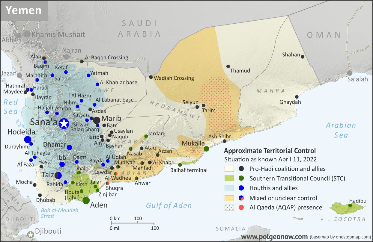
Just weeks after Yemen's separatist Southern Transitional Council (STC) swept victoriously across the country's eastern provinces, the tables turned dramatically. With their foreign backer, the United Arab Emirates, agreeing to withdraw from Yemen under pressure from Saudi Arabia, the separatists were forced in the first days of 2026 to beat a hasty retreat, even from parts of the southwest that they'd controlled for years prior.
Though the leaders of Yemen's Saudi-backed internationally-recognized government remain in exile in Riyadh, forces loyal to them now dominate most of southern and eastern Yemen. This newfound unity raises the prospect of a return to all-out war with the internationally-unrecognized "Houthi" government, which still governs more than half the country's population from its headquarters in official national capital Sana'a. Meanwhile, STC holdouts have withdrawn to their bastions of greatest support, and the local Al Qaeda chapter is flexing its muscles in some remote areas of the country.
This map and report are premium content available to paid subscribers of the PolGeoNow Conflict Mapping Service.
Want to see before you buy? Check out our most recent FREE SAMPLE Yemen map report!
Exclusive report includes:
- Up-to-date map of territorial control in the Yemeni Civil War, color-coded for the internationally-recognized government (IRG) and allies, led by the Saudi Arabia-backed Presidential Leadership Council (PLC) and including Islah, the Yemeni Emergency Forces, and the National/Homeland Shield Force, and now the Southern Giants Brigades; remaining holdouts of the UAE-backed separatist Southern Transitional Council (STC); forces of the unrecognized "Houthi" government; and estimated area of presence of Al Qaeda in the Arabian Peninsula (AQAP)
- Detailed indication of town-by-town control, including provincial boundaries, all major cities, and many smaller locations
- Markers for places recently appearing in the news, including Seiyun, Khasha'a, Rumah, Adwas, Houta, the Socotra Airport, and many more
- Concise, beginner-friendly summary of the current situation and key events from the end of 2025 to present, covering the entire period of the STC retreat and beyond
- Detailed timeline of changes to control and other major events since December 30, 2025, with links to sources
SUBSCRIBERS CLICK HERE TO VIEW FULL ARTICLE AND MAP:
Old Portal (members.polgeonow.com) | New Portal (controlmaps.polgeonow.com)
Not a member yet? Click here to learn more about our professional subscription service!
Can I purchase just this map?
This map and report are not available for automated purchase to non-subscribers. If you need access or republication rights for only this map report, contact service@polgeonow.com for options.


")