Old Portal (members.polgeonow.com) | New Portal (controlmaps.polgeonow.com)
(To see other maps in this series, view all Somalia updates.)
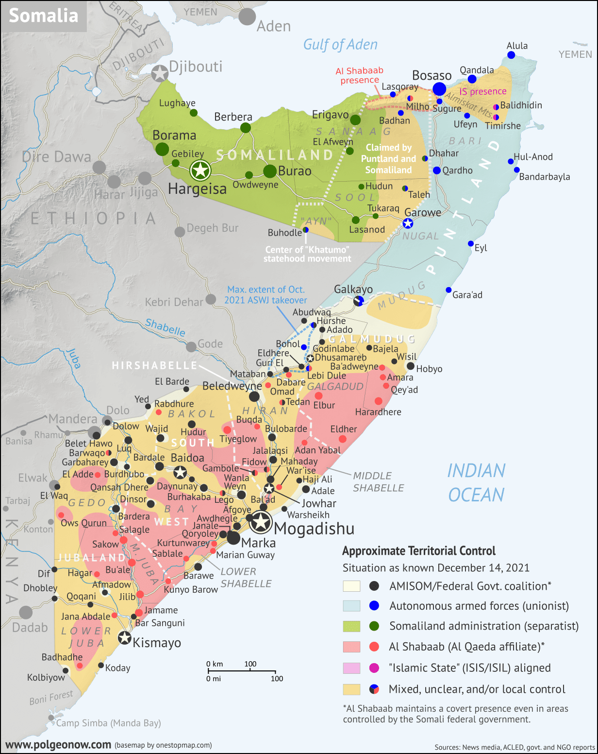
Map by onestopmap.com, Evan Centanni, and Djordje Djukic

Pro-federal forces, including local militias and other allies, have made remarkable gains against Al Shabaab in recent months, despite their advances in mid-2022 having been exaggerated. Al Shabaab has recently been driven out of several major towns that it governed unopposed for many years - potentially the biggest achievement of the pro-federal coalition in almost a decade.
See all this and more on the latest update to PolGeoNow's concise, professional Somalia control map, which includes a timeline of territorial changes and key events since our previous Somalia map report of December 2021, with sources cited.
This map and report are premium content, available to paid subscribers of the PolGeoNow Conflict Mapping Service.
Want to see before you subscribe? Check out our most recent FREE SAMPLE Somalia map!
Exclusive map report includes:
- Up-to-date illustration of current territorial control in Somalia, color-coded for the federal government coalition (including ATMIS peacekeepers), autonomous unionist forces, separatist Somaliland, Al Qaeda affiliate Al Shabaab, and fighters aligned with the so-called "Islamic State" (IS; formerly ISIS/ISIL). Areas of mixed or unclear control indicated separately. Colorblind accessible.
- Boundaries and labels for Somalia's official regions and states, including the self-proclaimed independent Republic of Somaliland and federal states Puntland, Galmudug, Jubaland, South West, and Hirshabelle. Illustrates the claims of both sides in the Somaliland-Puntland border dispute, as well as actual control.
- Detailed indication of city-by-city control, including many relevant smaller towns and villages.
- Locations of recent fighting and other important events, including Bo'o (Booco), Ali Gadud, Masagaway, Harardhere, Eldher, Bahdo (Baxdo), Qayib, and many more.
- Detailed timeline of territorial control changes and key political and humanitarian developments since December 14, 2021, with sources cited.
- Summary of the conflict situation and changes to the map over the past four months.
- Chronicle of the self-proclaimed Republic of Somaliland's international relations in its quest for recognition as an independent country (events included as part of timeline)
SUBSCRIBERS CLICK HERE TO VIEW FULL ARTICLE AND MAP:
Old Portal (members.polgeonow.com) | New Portal (controlmaps.polgeonow.com)
Not signed up yet? Click here to learn more about our professional subscription service!


