Showing posts with label iraq. Show all posts

Saturday, August 22, 2020

Iraq Control Map & Timeline: Turkey Expands Control in North - August 2020 (Subscription)

SUBSCRIBERS CLICK HERE TO PROCEED TO ARTICLE AND MAP

(To see other maps in this series, view all Iraq articles.)

Research by Djordje Djukic. Map by onestopmap.com, Evan Centanni, and Djordje Djukic

Subscribe for full access to all conflict map reports!

Iraq Control Map 2020, updated to August 21. Shows areas of Iraq under Turkey's military contro, ISIS control (Islamic State/ISIL/Daesh), and under the control of the Baghdad government, the Kurdistan Peshmerga, and the Yezidi Sinjar Alliance (YBS and YJE). Marks Khamtir and Halukah Mountains (Jabal Khamtir and Jabal Halukah), controlled by Turkish forces. Colorblind accessible.
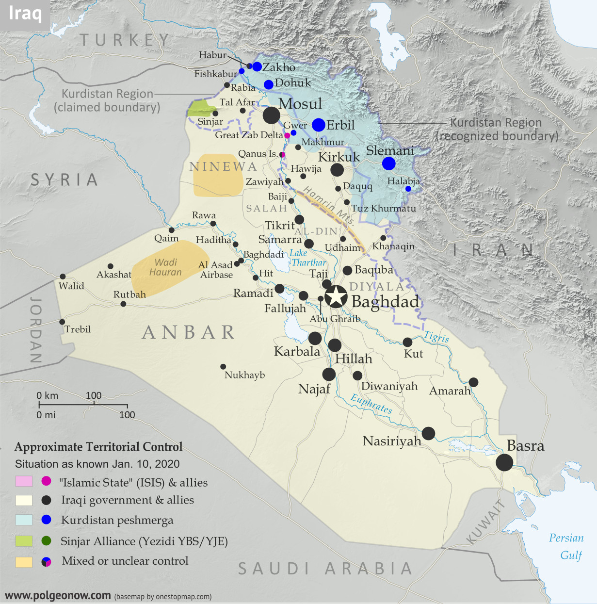
While Iraq's lines of control have mostly stayed the same since the beginning of the year, Turkey's military has been gradually increasing its control of the north. The incursion is part of the Turkish war against the Kurdish PKK, a rebel group from Turkey that now bases itself across the border in Iraq.

See all this and more on the latest update to PolGeoNow's concise, professional map of control in Iraq, including a timeline of changes since our previous Iraq map report of January 2020.

This map and report are premium content, available to paid subscribers of the PolGeoNow Conflict Mapping Service.

Want to see before you subscribe? Check out our most recent FREE SAMPLE Iraq map report!

Exclusive report includes:
  • Up-to-date map of current territorial control in Iraq, color-coded for the Iraqi government, "Islamic State" (ISIS/ISIL) fighters, Kurdistan's Peshmerga forces, and Yezidi militias. Colorblind accessible.
  • NEW: Turkish military control along the northern border, including key sites Mt. Khamtir (Jabal Khamtir) and Mt. Halukah (Jabal Halukah).
  • Detailed indication of town-by-town control, including all major cities and many smaller ones, as well as terrain, major roads, and provincial boundaries
  • Timeline of changes to the situation and related events since January, compiled by our Iraq-Syria specialist, with links to sources.
SUBSCRIBERS CLICK HERE TO PROCEED TO ARTICLE AND MAP

Not signed up yet? Click here to learn more about our professional subscription service!

Can I purchase just this map?
This map and report are not available for automated purchase to non-subscribers. If you need access or republication rights for only this map report, contact service@polgeonow.com for options.

Saturday, January 11, 2020

Iraq Control Map & Timeline - January 2020

There are newer versions of this map available. To see them, view all Iraq updates.

Iraq Control Map 2020, updated to January 10. Shows areas of Iraq under ISIS control (Islamic State/ISIL/Daesh), and under the control of the Baghdad government, the Kurdistan Peshmerga, and the Yezidi Sinjar Alliance (YBS and YJE). Colorblind accessible.
Basemap by Koen Adams of onestopmap.com, with territorial control by Evan Centanni and Djordje Djukic.
Contact us for permission to use this map.
(Subscribers click here to view this article in the member area)

Timeline by Djordje Djukic, with additional reporting by Evan Centanni

Iraq Map: Who Controls What in 2020

In the nearly two years since our previous Iraq control map update, there have been few major changes to the situation on the ground. But the so-called "Islamic State" (IS; formerly ISIS/ISIL) isn't gone, and recent reports say the group has begun regaining power in the country's north. Tensions have also escalated recently between the US and Iran - both countries are heavily involved in Iraq, and have long competed for influence there. Meanwhile, the self-governed Kurdistan region remains in control of the far north, despite having lost some its claimed territory to the Iraqi central government in the aftermath of its controversial 2017 independence vote.

Saturday, February 24, 2018

Iraq Control Map & Timeline - February 2018 (Subscription)

SUBSCRIBERS CLICK HERE TO PROCEED TO ARTICLE AND MAP

There are newer versions of this map available. To see them, view all Iraq updates.

Research by Djordje Djukic. Map by onestopmap.com, Evan Centanni, and Djordje Djukic

Subscribe for full access to all conflict map reports!

Detailed map of territorial control in Iraq as of February 22, 2018. Shows territory held by the so-called Islamic State (ISIS, ISIL), the Baghdad government, the Kurdistan Peshmerga, and the Yezidi Sinjar Alliance (YBS and YJE). Colorblind accessible.
Since November, pro-government forces in Iraq have nearly, but not entirely, cleared the country of control by the so-called "Islamic State" (ISIS/ISIL), with the group still reportedly holding out in parts of the western desert.

See all this and more on the latest update to PolGeoNow's concise, professional map of control in Iraq's civil war, including a timeline of changes since our previous Iraq map report of November 2017.

This map and report are premium content, available to paid subscribers of the PolGeoNow Conflict Mapping Service.

Want to see before you subscribe? Check out our most recent FREE SAMPLE Iraq map report!

Exclusive report includes:
  • Up-to-date map of current territorial control in Iraq, color-coded for the Iraqi government, "Islamic State" (ISIS/ISIL) fighters, Kurdistan's Peshmerga forces, and Yezidi militias. Colorblind accessible.
  • Detailed indication of town-by-town control, including all major cities and many smaller ones, as well as terrain, major roads, and provincial boundaries
  • Timeline of changes to the situation since the end of November, compiled by our Iraq-Syria specialist, with links to sources.
SUBSCRIBERS CLICK HERE TO PROCEED TO ARTICLE AND MAP

Not signed up yet? Click here to learn more about our professional subscription service!

Can I purchase just this map?
This map and report are not available for automated purchase to non-subscribers. If you need access or republication rights for only this map report, contact service@polgeonow.com for options.

Thursday, November 30, 2017

Iraq Control Map & Timeline: "Islamic State" Loses Last Towns - November 2017 (Subscription)

SUBSCRIBERS CLICK HERE TO PROCEED TO ARTICLE AND MAP

There are newer versions of this map available. To see them, view all Iraq updates.

Research by Djordje Djukic. Map by onestopmap.com, Evan Centanni, and Djordje Djukic

Subscribe for full access to all conflict map reports!

Detailed map of territorial control in Iraq as of November 29, 2017 after the recapture of Rawa, Qaim and government seizure of additional Kurdish-held territories. Shows territory held by the so-called Islamic State (ISIS, ISIL), the Baghdad government, the Kurdistan Peshmerga, and the Yezidi Sinjar Alliance (YBS and YJE). Colorblind accessible.
Since mid-October, government forces have recaptured the last towns in Iraq controlled by the so-called "Islamic State" (ISIS/ISIL), even while taking more territory from the Kurdistan Region in the wake of its controversial independence vote.

See all this and more on the latest update to PolGeoNow's concise, professional map of control in Iraq's civil war, including a timeline of changes since our previous Iraq map report of October 2017.

This map and report are premium content, available to paid subscribers of the PolGeoNow Conflict Mapping Service.

Want to see before you subscribe? Check out our most recent FREE SAMPLE Iraq map report!

Exclusive report includes:
  • Up-to-date map of current territorial control in Iraq, color-coded for the Iraqi government, "Islamic State" (ISIS/ISIL) fighters, Kurdistan's Peshmerga forces, and Yezidi militias. Colorblind accessible.
  • Detailed indication of town-by-town control, including all major cities and many smaller ones, as well as terrain, major roads, and provincial boundaries
  • Timeline of changes to the situation since mid-October, compiled by our Iraq-Syria specialist, with links to sources
SUBSCRIBERS CLICK HERE TO PROCEED TO ARTICLE AND MAP

Not signed up yet? Click here to learn more about our professional subscription service!

Can I purchase just this map?
This map and report are not available for automated purchase to non-subscribers. If you need access or republication rights for only this map report, contact service@polgeonow.com for options.

Monday, October 16, 2017

Iraq Control Map & Timeline: Government Takes Kirkuk from Kurdistan - October 2017

There are newer versions of this map available. To see them, view all Iraq updates.

Detailed map of territorial control in Iraq as of October 16, 2017 after the recapture of Hawija and Tal Afar and government seizure of Kirkuk. including territory held by the so-called Islamic State (ISIS, ISIL), the Baghdad government, the Kurdistan Peshmerga, and the Yezidi Sinjar Alliance (YBS and YJE). Colorblind accessible.
Basemap by Koen Adams of onestopmap.com, with territorial control by Evan Centanni and Djordje Djukic. All rights reserved.
(Subscribers click here to view this article in the member area)

Timeline by Djordje Djukic

Summary of Events
Since our previous Iraq control map update in late July, there have been big changes to territorial control in Iraq, all involving expansions of control for the Iraqi military and its close allies (mainly police and Iran-backed militias): The so-called "Islamic State" (IS; formerly ISIS/ISIL) has been driven out of its Tal Afar and Hawija enclaves, and the disputed city of Kirkuk has been retaken from Kurdish forces in response to the controversial Kurdistan independence referendum. Iraqi government forces have also begun to chip away at the remaining swath of IS territory in the countryside of Anbar province, capturing the town of Anah on the road to the Syrian border.

Tuesday, September 26, 2017

Kurdistan Votes to Leave Iraq: What Happens Next?

This article is part of our Referendum 2017 coverage, spotlighting controversial independence votes in two of the world's autonomous regions: Kurdistan voted yesterday on independence from Iraq, and Catalonia will vote this Sunday on leaving Spain. 


Map of Iraq and Kurdistan's place within it, published in advance of the 2017 Iraqi Kurdistan independence referendum. Includes disputed territories and territorial control as of July 30, 2017. Colorblind accessible.
Residents of Iraqi Kurdistan voted Monday in a controversial referendum on whether to declare independence from Iraq, with preliminary results showing almost 92% in favor of separation. We're still waiting for (hopefully) detailed official results so we can map out how different districts voted. But in the meantime, let's answer some of the big questions:

Will Kurdistan become independent now?

The Kurdistan region's government considers this vote official and "binding", in contrast to an informal 2005 referendum, even though the Iraqi federal government in Baghdad considers it completely illegal. But it was never intended to trigger an automatic declaration of independence.

Instead, Kurdistan leader Masoud Barzani has promised to use a "YES" vote as leverage to negotiate independence with Iraqi government. So far, no date has been set for Kurdistan's declaration of independence, and it could still be years away.

Friday, September 22, 2017

Referendum 2017: Iraqi Kurdistan Map

Two of the world's autonomous regions are about to vote in controversial independence referendums. Iraqi Kurdistan decides on independence from Iraq this Monday, and on October 1 Catalonia plans to vote on leaving Spain. PolGeoNow will be covering these events with a series of articles, but in the meantime we couldn't wait to share our new Iraqi Kurdistan map with you!

Map of Iraq and Kurdistan's place within it, published in advance of the 2017 Iraqi Kurdistan independence referendum. Includes disputed territories and territorial control as of July 30, 2017. Colorblind accessible.
Graphic by Evan Centanni and Djordje Djukic, incorporating base map by Koen Adams of onestopmap.com. All rights reserved.

Iraqi Kurdistan Independence Referendum

The Kurdistan Region of Iraq (Iraqi Kurdistan for short) is just part of the traditional homeland of the Kurds, the Middle East's fourth-largest ethnic group after Arabs, Persians, and Turks.

Many Kurds also live in Turkey, Syria, and Iran. But Iraqi Kurdistan is where they have the most legal rights, governing themselves in what's internationally recognized as an autonomous region within Iraq.

But all's not well in Kurdistan-Iraq relations. Iraqi Kurds suffered through horrific violence and persecution in the 1980s and 90s, and now the region's top politician has staked his reputation on separating Kurdistan from Iraq permanently.

Monday, July 31, 2017

Iraq Control Map & Timeline: "Islamic State" Loses Mosul - July 2017 (Subscription)

SUBSCRIBERS CLICK HERE TO PROCEED TO ARTICLE AND MAP

There are newer versions of this map available. To see them, view all Iraq updates.

Research by Djordje Djukic. Map by onestopmap.com, Evan Centanni, and Djordje Djukic

Subscribe for full access to all conflict map reports!

Detailed map of territorial control in Iraq as of July 30, 2017 after the end of the Battle of Mosul, including territory held by the so-called Islamic State (ISIS, ISIL), the Baghdad government, the Kurdistan Peshmerga, and the Yezidi Sinjar Alliance (YBS and YJE). Colorblind accessible.
In the past month, Iraqi government forces and allies have completed their recapture of Mosul, the third biggest city in Iraq and the largest urban center ever controlled by the so-called "Islamic State" (IS; formerly ISIS/ISIL) in any country.

See all this and more on the latest update to PolGeoNow's concise, professional map of control in Iraq's civil war, including a timeline of changes since our previous Iraq map report of June 2017.

This map and report are premium professional content, available to paid subscribers of the PolGeoNow Conflict Mapping Service.

Want to see before you subscribe? Check out our most recent FREE SAMPLE Iraq map report!

Exclusive report includes:
  • Up-to-date map of current territorial control in Iraq, color-coded for the Iraqi government, "Islamic State" (ISIS/ISIL) fighters, and Kurdistan's Peshmerga forces. Colorblind accessible.
  • New: Separate color for Yezidi militias of the "Sinjar Alliance", who control their own territory near the Syrian border.
  • Detailed indication of town-by-town control, including all major cities and many smaller ones, as well as terrain, major roads, and provincial boundaries
  • Timeline of changes to the situation since mid-June, compiled by our Iraq-Syria specialist, with links to sources
SUBSCRIBERS CLICK HERE TO PROCEED TO ARTICLE AND MAP

Not signed up yet? Click here to learn more about our professional subscription service!

Can I purchase just this map?
This map and report are not available for automated purchase to non-subscribers. If you need access or republication rights for only this map report, contact service@polgeonow.com for options.

Friday, June 16, 2017

Iraq Control Map & Timeline - June 2017 (Subscription)

SUBSCRIBERS CLICK HERE TO PROCEED TO ARTICLE AND MAP

There are newer versions of this map available. To see them, view all Iraq updates.

Research by Djordje Djukic. Map by onestopmap.com, Evan Centanni, and Djordje Djukic

Subscribe for full access to all conflict map reports!

Detailed map of territorial control in Iraq as of June 15, 2017, including territory held by the so-called Islamic State (ISIS, ISIL), the Baghdad government, and the Kurdistan Peshmerga. Shows developments in the ongoing coalition battle to recapture the city of Mosul. Includes key locations from recent events, such as Baaj, Al-Hadar, Qayrawan, and the Safouk and Jayar Ghalfas border crossings. Colorblind accessible.
In the past three months, Iraqi government forces have made slow but steady progress against the so-called "Islamic State" in the city of Mosul, while pro-government militias have pushed westward from the city all the way to the Syrian border.

See all this and more on the latest update to PolGeoNow's concise, professional map of control in Iraq's civil war, including a timeline of changes since our previous Iraq map report of March 2017.

This map and report are premium professional content, available to paid subscribers of the PolGeoNow Conflict Mapping Service.

Want to see before you subscribe? Check out our most recent FREE SAMPLE Iraq map report!

Exclusive report includes:
  • Up-to-date map of current territorial control in Iraq, color-coded for the Iraqi government, "Islamic State" (ISIS/ISIL) fighters, and Kurdistan's Peshmerga forces. Colorblind accessible.
  • Detailed indication of town-by-town control, including all major cities and many smaller ones, as well as major roads and provincial boundaries
  • Markers for key areas of recent fighting such as Baaj, Al-Hadar, Qayrawan, and the Safouk and Jayar Ghalfas border crossings
  • Timeline of changes to the situation since mid-March, compiled by our Iraq-Syria specialist, with links to sources
SUBSCRIBERS CLICK HERE TO PROCEED TO ARTICLE AND MAP

Not signed up yet? Click here to learn more about our professional subscription service!

Can I purchase just this map?
This map and report are not available for automated purchase to non-subscribers. If you need access or republication rights for only this map report, contact service@polgeonow.com for options.

Monday, March 20, 2017

2016 Year in Review: Rebel Control Around the World

The rebel control maps in this article were produced for PolGeoNow's professional conflict map subscription service. Full-size versions of all PolGeoNow conflict maps, along with territorial control timelines, are accessible to subscribers. You can learn more about our map subscriptions here. Non-subscribers can also view our collection of free sample control map reports.

Map of fighting and territorial control in Syria's Civil War (Free Syrian Army rebels, Kurdish YPG, Syrian Democratic Forces (SDF), Al-Nusra Front, Islamic State (ISIS/ISIL), and others), updated for February 2016. Now includes terrain and major roads (highways). Highlights recent locations of conflict and territorial control changes, such as Menagh airbase, northern Aleppo, Salma, Rabia, Nubl, Baghaliya, Tishrin Dam, and more.
Syria in February 2016

Map of fighting and territorial control in Syria's Civil War (Free Syrian Army rebels, Kurdish YPG, Syrian Democratic Forces (SDF), Jabhat Fateh al-Sham (Al-Nusra Front), Islamic State (ISIS/ISIL), and others), updated to December 18, 2016. Now includes terrain and major roads (highways). Includes recent locations of conflict and territorial control changes, such as Aleppo, Palmyra, Khan al-Shih, Mayda'ani, and more. Colorblind accessible.
Syria in December 2016

The Year in Territorial Control Changes

For the past three years, PolGeoNow has published a "Year in Review" article to summarize all the political geography news that's happened in the past 12 months. The 2014 and 2015 articles included news about changing territorial control in conflict zones, but because this is a major topic of its own, we've chosen to split these events into a separate article for 2016. So read on for a concise summary of last year's rebel control changes...

See Also: 2016 Year in Review: Country & Border Changes 
 

Syria, Iraq, and the "Islamic State"

The Syrian Civil War continued to be the biggest armed conflict in the world through 2016, as well as a prominent example of a country whose territory isn't all controlled by the recognized government. During the past year, pro-government forces scored some major victories against the rebels, recapturing the country's second largest city and gradually increasing control in areas around the capital.

Saturday, March 18, 2017

Iraq Control Map & Timeline - March 2017 (Subscription)

SUBSCRIBERS CLICK HERE TO PROCEED TO ARTICLE AND MAP

There are newer versions of this map available. To see them, view all Iraq updates.

Research by Djordje Djukic. Map by onestopmap.com, Evan Centanni, and Djordje Djukic

Subscribe for full access to all conflict map reports!

Detailed map of territorial control in Iraq as of March 17, 2017, including territory held by the so-called Islamic State (ISIS, ISIL), the Baghdad government, and the Kurdistan Peshmerga. Shows developments in the ongoing coalition battle to recapture the city of Mosul. Includes key locations from recent events, such as Mosul, Badush, and Tal Abta. Colorblind accessible. Since January, fighting has raged on for control of Mosul, Iraq's second-largest city. Iraqi government forces and allies have secured control of the city's eastern half from the so-called "Islamic State" (IS; formerly ISIS/ISIL), and have continued to gain ground both in the city and in the surrounding region.
 
See all this and more on the latest update to PolGeoNow's concise, professional map of control in Iraq's civil war, including a timeline of changes since our previous Iraq map report of November 2016.

This map and report are premium professional content, available to paid subscribers of the PolGeoNow Conflict Mapping Service.

Want to see before you subscribe? Check out our most recent FREE SAMPLE Iraq map report!

Exclusive report includes:
  • Up-to-date map of current territorial control in Iraq, color-coded for the Iraqi government, "Islamic State" (ISIS/ISIL) extremists, and Kurdistan's Peshmerga forces. Colorblind accessible.
  • Detailed indication of town-by-town control, including all major cities and many smaller ones, as well as major roads and provincial boundaries
  • Markers for key areas of recent fighting such as Mosul, Badush, and Tal Abta
  • Timeline of changes to the situation since early January, compiled by our Iraq-Syria specialist, with links to sources
SUBSCRIBERS CLICK HERE TO PROCEED TO ARTICLE AND MAP

Not signed up yet? Click here to learn more about our professional subscription service!

Can I purchase just this map?
This map and report are not available for automated purchase to non-subscribers. If you need access or republication rights for only this map report, contact service@polgeonow.com for options.

Tuesday, January 10, 2017

Iraq Control Map & Timeline: The Battle for Mosul - January 2017 (Subscription)

SUBSCRIBERS CLICK HERE TO PROCEED TO ARTICLE AND MAP

There are newer versions of this map available. To see them, view all Iraq updates.

Research by Djordje Djukic. Map by onestopmap.com, Evan Centanni, and Djordje Djukic

Subscribe for full access to all conflict map reports!

Detailed map of territorial control in Iraq as of January 10, 2016, including territory held by the so-called Islamic State (ISIS, ISIL), the Baghdad government, and the Kurdistan Peshmerga. Shows developments in the ongoing coalition battle to recapture the city of Mosul. Includes key locations from recent events, such as Mosul, Al-Sagra, and Hamam al-Alil. Colorblind accessible. Over the past two months, a battle has raged for control of Mosul, the second-largest city in Iraq and the largest controlled by the so-called "Islamic State" (ISIS/ISIL). Government and allied forces have made slow but steady progress in the city and nearby areas, even while advancing in western Iraq's Anbar province at the same time.
 
See all this and more on the latest update to PolGeoNow's concise, professional map of control in Iraq's civil war, including a timeline of changes since our previous Iraq map report of November 2016.

This map and report are premium professional content, available to paid subscribers of the PolGeoNow Conflict Mapping Service.

Want to see before you subscribe? Check out our most recent FREE SAMPLE Iraq map report!

Exclusive report includes:
  • Up-to-date map of current territorial control in Iraq, color-coded for the Iraqi government, "Islamic State" (ISIS/ISIL) extremists, and Kurdistan's Peshmerga forces. Colorblind accessible.
  • Detailed indication of town-by-town control, including provincial boundaries, all major cities, and many smaller ones
  • Markers for key areas of recent fighting such as Mosul, Tal Afar, Al-Sagra, and Hamam al-Alil
  • Timeline of changes to the situation since early November, compiled by our Iraq specialist, with links to sources
SUBSCRIBERS CLICK HERE TO PROCEED TO ARTICLE AND MAP

Not signed up yet? Click here to learn more about our professional subscription service!

Can I purchase just this map?
This map and report are not available for automated purchase to non-subscribers. If you need access or republication rights for only this map report, contact service@polgeonow.com for options.

Friday, November 4, 2016

Iraq Control Map & Timeline: The Siege of Mosul - November 2016 (Subscription)

SUBSCRIBERS CLICK HERE TO PROCEED TO ARTICLE AND MAP

There are newer versions of this map available. To see them, view all Iraq updates.

Research by Djordje Djukic. Map by onestopmap.com, Evan Centanni, and Djordje Djukic

Subscribe for full access to all conflict map reports!

Detailed map of territorial control in Iraq as of November 4, 2016, including territory held by the so-called Islamic State (ISIS, ISIL), the Baghdad government, and the Kurdistan Peshmerga. Shows developments in the ongoing coalition battle to recapture the city of Mosul. Includes key locations from recent events, such as Bashiqa, Sharqat, and Bartella. Colorblind accessible. The battle is now on for Mosul, the so-called Islamic State's (ISIS/ISIL) biggest city. A grand coalition of Iraqi military, Shiite and Sunni militias, and Kurdistan's Peshmerga forces - with controversial help from the Turkish military - have now entered and mostly surrounded the city.
 
See all this and more on the latest update to PolGeoNow's concise, professional map of control in Iraq's civil war, including a timeline of changes since our previous Iraq map report of September 2016.

This map and report are premium professional content, available to paid subscribers of the PolGeoNow Conflict Mapping Service.

Want to see before you subscribe? Check out our most recent FREE SAMPLE Iraq map report!

Exclusive report includes:
  • Up-to-date map of current territorial control in Iraq, color-coded for the Iraqi government, "Islamic State" (ISIS/ISIL) extremists, and Kurdistan's Peshmerga forces. Colorblind accessible.
  • Detailed indication of town-by-town control, including provincial boundaries, all major cities, and many smaller ones
  • Markers for key areas of recent fighting such as Mosul, Bashiqa, Sharqat, and Bartella
  • Timeline of changes to the situation since early September, compiled by our Iraq specialist, with links to sources
SUBSCRIBERS CLICK HERE TO PROCEED TO ARTICLE AND MAP

Not signed up yet? Click here to learn more about our professional subscription service!

Can I purchase just this map?
This map and report are not available for automated purchase to non-subscribers. If you need access or republication rights for only this map report, contact service@polgeonow.com for options.

Wednesday, September 7, 2016

Iraq Control Map & Report: September 2016

There are newer versions of this map available. To see them, view all Iraq updates.

Detailed map of territorial control in Iraq as of September 5, 2016, including territory held by the so-called Islamic State (ISIS, ISIL), the Baghdad government, and the Kurdistan Peshmerga. Includes results of recent fighting around Qaiyarah (Qayyarah) south of Mosul. Color blind accessible.
Basemap by Koen Adams of onestopmap.com, with territorial control by Evan Centanni and Djordje Djukic. All rights reserved.
(Subscribers click here to view this article in the member area.)

Research and timeline by Djordje Djukic

Summary of Recent Events
After recapturing Ramadi from the so-called "Islamic State" (IS; formerly ISIS/ISIL), the Iraqi government and allies have set their sights on Mosul, the largest IS-controlled city, and until a few years ago the second largest city in Iraq (some sources say half or more of its population fled after the IS takeover in 2014). Since our last Iraq control map report at the end of June, the main change to territorial control has been the government capture of Qaiyarah, a town south of Mosul that's still more or less surrounded by IS and Kurdish controlled ground.

Friday, July 1, 2016

Iraq Control Map & Report: July 2016 (Subscription)

MEMBERS CLICK HERE TO PROCEED TO ARTICLE AND MAP

There are newer versions of this map available. To see them, view all Iraq updates.

Research by Djordje Djukic. Map by onestopmap.com, Evan Centanni, and Djordje Djukic

Subscribe for full access to all conflict map reports!

Detailed map of territorial control in Iraq as of June 30, 2016, including territory held by the so-called Islamic State (ISIS, ISIL), the Baghdad government, and the Kurdistan Peshmerga. Includes recent flashpoints such as Fallujah, Karma, Saqlawiyah, and Akashat. (color blind accessible) The Iraqi army and allies have driven the so-called "Islamic State" (ISIS/ISIL) out of Fallujah, its last stronghold in central Iraq, even as it continues to lose ground on other fronts.
 
See all this and more on the latest update to PolGeoNow's concise, professional map of control in Iraq's civil war, including a timeline of changes since our previous Iraq map report of May 2016.

This map and report are premium professional content, available to paid subscribers of the PolGeoNow Conflict Mapping Service.

Want to see before you subscribe? Check out our most recent FREE SAMPLE Iraq map report!

Exclusive map report includes:
  • Up-to-date map of current territorial control in Iraq, color-coded for the Iraqi government, "Islamic State" (ISIS/ISIL) extremists, and Kurdistan's Peshmerga forces
  • Detailed indication of town-by-town control, including provincial boundaries, all major cities, and many smaller ones
  • Markers for key areas of recent fighting such as Fallujah, Karma, Saqlawiyah, and Akashat
  • Timeline of changes to the situation since mid-May, compiled by our Iraq specialist, with links to sources 
  • New since last year: Terrain shading and major highways included on map for geographic context

MEMBERS CLICK HERE TO PROCEED TO ARTICLE AND MAP

Not a member yet? Click here to learn more about our professional subscription service!

Can I purchase just this map?
This map and report are not available for automated purchase to non-subscribers. If you need access or republication rights for only this map report, contact service@polgeonow.com for options.

Thursday, May 19, 2016

Iraq Control Map & Report: May 2016 (Subscription)

MEMBERS CLICK HERE TO PROCEED TO ARTICLE AND MAP

There are newer versions of this map available. To see them, view all Iraq updates.

Research by Djordje Djukic. Map by onestopmap.com, Evan Centanni, and Djordje Djukic

Subscribe for full access to all conflict map reports!

Detailed map of territorial control in Iraq as of May 17, 2016, including territory held by the so-called Islamic State (ISIS, ISIL), the Baghdad government, and the Kurdistan Peshmerga. Includes recent flashpoints such as Rutbah, Doulab, Tuz Khurmatu, and more. The past month has seen several small victories of Iraqi government forces against the so-called "Islamic State" (ISIS/ISIL), as well as a handful of other notable territorial events.
 
See all this and more on the latest update to PolGeoNow's concise, professional map of control in Iraq's civil war, including a timeline of changes since our previous Iraq map report of April 2016.

This map and report are premium professional content, available to paid subscribers of the PolGeoNow Conflict Mapping Service.

Want to see before you subscribe? Check out our most recent FREE SAMPLE Iraq map report!

Exclusive map report includes:
  • New since last year: Terrain shading and major highways included on map for geographic context
  • Up-to-date map of current territorial control in Iraq, color-coded for the Iraqi government, "Islamic State" (ISIS/ISIL) extremists, and Kurdistan's Peshmerga forces
  • Detailed indication of town-by-town control, including provincial boundaries, all major cities, and many smaller ones
  • Markers for key areas of recent fighting such as Rutbah, Doulab, Tuz Khurmatu, and more
  • Timeline of changes to the situation since mid-April, compiled by our Iraq specialist, with links to sources

MEMBERS CLICK HERE TO PROCEED TO ARTICLE AND MAP

Not a member yet? Click here to learn more about our professional subscription service!

Can I purchase just this map?
This map and report are not available for automated purchase to non-subscribers. If you need access or republication rights for only this map report, contact service@polgeonow.com for options.

Thursday, April 14, 2016

Iraq Control Map & Report: April 2016 (Subscription)

SUBSCRIBERS CLICK HERE TO PROCEED TO ARTICLE AND MAP

There are newer versions of this map available. To see them, view all Iraq updates.

Research by Djordje Djukic. Map by onestopmap.com, Evan Centanni, and Djordje Djukic

Subscribe for full access to all conflict map reports!

Download PDF:
Buy now
New discounted price!
Detailed map of territorial control in Iraq's ongoing war as of April 14, 2016, including territory held by the so-called Islamic State (ISIS, ISIL), the Baghdad government, and the Kurdistan Peshmerga. Includes recent flashpoints including Ramadi, Hit, Bashir, and more. New: Improved map now includes terrain and major roads!

The past four months have seen two significant victories for Iraqi government forces over the so-called "Islamic State" (ISIS/ISIL), despite floundering attempts to retake the city of Mosul.
 
See all this and more on the latest update to PolGeoNow's concise, professional map of control in Iraq's civil war, including a timeline of changes since our previous Iraq map report in December 2015.

This map and report are professional subscriber content, available to paid members or for separate purchase. Download PDF (US$14.99) New discounted price!

Want to see before you buy? Check out our most recent FREE SAMPLE Iraq map report!

Exclusive map report includes:
Detailed map of territorial control in Iraq's ongoing war as of April 14, 2016, including territory held by the so-called Islamic State (ISIS, ISIL), the Baghdad government, and the Kurdistan Peshmerga. Includes recent flashpoints including Ramadi, Hit, Bashir, and more.
  • New since last time: Terrain shading and major highways included on map for geographic context
  • Up-to-date map of current territorial control in Iraq, color-coded for the Iraqi government, "Islamic State" (ISIS/ISIL) extremists, and Kurdistan's Peshmerga forces
  • Detailed indication of town-by-town control, including provincial boundaries, all major cities, and many smaller ones
  • Markers for key areas of recent fighting such as Ramadi, Hit, Bashir, and more
  • Timeline of changes to the situation since December, compiled by our Iraq specialist, with links to sources 
Note: Republishing rights are not included with PDF purchases or basic subscriptions. If you need to use one of our maps in print or online, please contact service@polgeonow.com.

SUBSCRIBERS CLICK HERE TO PROCEED TO ARTICLE AND MAP

NON-MEMBERS: PURCHASE MAP REPORT

Not a member yet? Click here to learn about our professional subscription service!


Thursday, December 24, 2015

War in Iraq: Map of "Islamic State" Control in December 2015 (Subscription)

MEMBERS CLICK HERE TO PROCEED TO ARTICLE AND MAP

There are newer versions of this map available. To see them, view all Iraq updates.

Detailed map of territorial control in Iraq as of December 23, 2015, including territory held by the so-called Islamic State (ISIS, ISIL), the Baghdad government, and the Kurdistan Peshmerga. Includes recent flashpoints including Ramadi, Baiji, Sinjar, and the Kirkuk-Daquq area.
Subscribe for full access to all conflict map reports!

   Download PDF:
Buy now
Research and timeline by Djordje Djukic; map and additional reporting by Evan Centanni

Though Iraq's current war has been proceeding at a less-intense pace than Syria's, there have been several important changes to territorial control in the past half a year, all involving the so-called "Islamic State" (ISIS) losing ground to the Iraqi government and Kurdistan's Peshmerga force.

See all this and more on the newest update to PolGeoNow's concise, professional-quality Iraq control map, which includes a timeline of changes since our previous Iraq map report in July.

This map and report are professional subscriber content, accessible to paid members or by separate purchase. Download PDF (US$19.99)

Want to see before you buy? Check out our most recent FREE SAMPLE Iraq map report!

Exclusive map report includes:
  • Up-to-date map of current territorial control in Iraq, color-coded for the Iraqi government, "Islamic State" (ISIS/ISIL) extremists, and Kurdistan's Peshmerga forces
  • Detailed indication of town-by-town control, including provincial boundaries, all major cities, and many smaller ones
  • Markers for key areas of recent fighting such as Ramadi, Baiji, Sinjar, and more
  • Timeline of changes to the situation since July, compiled by our Iraq specialist, with links to sources 
Note: Republishing rights are not included with PDF purchases or basic subscriptions. If you need to use one of our maps in print or online, contact service@polgeonow.com.

MEMBERS CLICK HERE TO PROCEED TO ARTICLE AND MAP

Not a member yet? Click here to learn more about our professional subscription service!


Friday, July 24, 2015

War in Iraq: Map of "Islamic State" Control in July 2015 (Subscription)

There are newer versions of this map available. To see them, view all Iraq updates.

Detailed map of territorial control in Iraq as of July 23, 2015, including territory held by the so-called Islamic State (ISIS, ISIL), the Baghdad government, and the Kurdistan peshmerga. Includes recent flashpoints including Ramadi, Baiji, Habaniyah, Jalawla, and Walid border crossing.

Download PDF:
Buy now


(Subscribe via Paypal to view all premium content online)
Timeline by Djordje Djukic; map and additional reporting by Evan Centanni

Since May, fighting in Iraq has seen small but potentially important advances by all sides, including the Baghdad government (with Iranian support), the "Islamic State" extremists, and Kurdistan's peshmerga.

See all this and more on the newest update to PolGeoNow's Iraq territorial control map, which includes a timeline of changes since our previous Iraq map report in May.

This map and report are exclusive premium content, available to paid subscribers or for separate purchase.
Download PDF (US$14.99)

Want to see before you buy? Check out our most recent FREE SAMPLE Iraq map report!

Exclusive map report includes:
  • Up-to-date map of current territorial control in Iraq, color-coded for the Iraqi government, "Islamic State" (ISIS/ISIL) extremists, and Kurdish peshmerga forces
  • Detailed indication of town-by-town control, including provincial boundaries, all major cities, and many smaller ones
  • Markers for key areas of recent fighting such as Baiji, Ramadi, Husaybah, Walid border crossing, and more
  • Timeline of changes to the situation since May, compiled by our Iraq specialist, with links to sources

MEMBERS CLICK HERE TO PROCEED TO ARTICLE AND MAP

NOT A MEMBER YET? SUBSCRIBE NOW!

Friday, May 22, 2015

War in Iraq: Map of Islamic State Control in May 2015

There are newer versions of this map available. To see them, view all Iraq updates.

This is a free sample of our Iraq territorial control map. To access more Iraq control map updates like this one, sign up now for our conflict map subscription service!

Detailed map of territorial control in Iraq as of May 20, 2015, including territory held by the Islamic State (ISIS, ISIL), the Baghdad government, and the Kurdistan Peshmerga. Includes recent flashpoints including Ramadi, Tikrit, Habbaniyah, Khaldiya, Sinjar, and others, as well as the recently created province of Halabja in Iraqi Kurdistan.
Map by Evan Centanni, starting from blank map by NordNordWest. License: CC BY-SA
Subscribers click here to view this article in the ad-free members area. Not a member yet? Subscribe now!

Timeline by Djordje Djukic, with additional reporting by Evan Centanni

A City for a City
Since PolGeoNow published our February map of control in Iraq, two major cities have changed hands, in opposite directions. Tikrit, known as the home region of former leader Saddam Hussein, was the Islamic State's farthest-forward prize in its spectacular takeover of northern Iraq last June. A priority for Iraq's struggling Baghdad government, Tikrit was finally taken back this March and April in a major push by Shiite militias, led by Iran and ultimately supported by U.S.-Arab coalition airstrikes.