Monday, December 30, 2013

2013: The Year in Political Geography Changes

By Evan Centanni

Premium members click here to view this article in the ad-free members area. Not a member yet? Subscribe now!

 Although popular for maps of territorial control in conflict zones, PolGeoNow's original mission is tracking formal changes to the world's political geography. When new countries appear, borders change, and territorial disputes arise or are settled, you'll hear about it here. As 2013 draws to a close, here's our look back at the major events of the year:

Map of the Palestinian Territories, now known in the official standard as
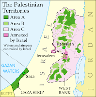
"State of Palestine"

Country Name Changes
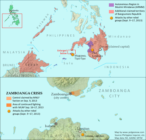
This year didn't see the creation of any new countries (unless you count the failed bid of the Bangsamoro Republik), but there were a few changes to country names. In October, the African island country of Cape Verde chose to change its official English name to "Cabo Verde", with the long form being "Republic of Cabo Verde". This brings it in line with the name in Portuguese, the country's official language. Meanwhile, in January, Libya established its full name as "State of Libya," after more than a year of going without an official long-form name. Since the 2011 revolution, the new government had been calling the country anything but Muammar Gaddafi's preferred "Great Socialist People's Libyan Arab Jamahiriya".

Tuesday, December 24, 2013

South Sudan Crisis: Rebel Control Map (Premium Content)

There are newer versions of this map available. To see the full list of updates, view all South Sudan articles

Report and map of rebel control in South Sudan's December 2013 political crisis; includes indications of control by state and city, including Juba, Bor, Bentiu, Malakal, and more

Download PDF
buy


After a sudden outbreak of political violence last week, the military of South Sudan has fragmented into two competing factions, with rebellious defectors capturing a large swath of the world's newest country. PolGeoNow now presents the first map of rebel control in South Sudan's ongoing crisis, an exclusive for premium subscribers and purchasers.

Premium article includes:
  • Exclusive, up-to-date map of rebel control by state and city in South Sudan's ongoing uprising
  • Outline of the course of events so far, including the captures of three state capitals by rebel forces
  • Brief description of the causes and humanitarian consequences of the current conflict
Members click here to proceed to article and map

Not a member yet? Subscribe Now!


Saturday, December 14, 2013

Syria Civil War Map: December 2013 (#12)

There are newer versions of this map available. To see them, view all Syria updates.

In addition to updates on the situation, our updated Syria control map now distinguishes the territory of extremist groups ISIS and Al-Nusra from that of Free Syrian Army or mixed rebel coalitions. (To see other maps in this series, view all Syria updates.)

Tired of waiting months for Syria map updates and briefings? Subscribers to our premium member service will soon begin seeing much more frequent Syria control updates. Don't miss out - sign up now!

Map of fighting and territorial control in Syria's Civil War (Free Syrian Army rebels, Kurdish groups, Al-Nusra Front, ISIS/ISIL and others), updated for December 2013. Includes recent locations of conflict and territorial control changes, Al-Safira, Khanaser, Maaloula, Qara, Nabek, and .
Area of fighting and territorial control in Syria's civil war, updated for December 2013. Map by Evan Centanni, starting from this blank map by German Wikipedia user NordNordWest. License: CC BY-SA
Premium members click here to view this article in the ad-free members area. Not a member yet? Subscribe now!

Al-Nusra and the ISIS
In addition to updates on the situation since our previous Syria war map, this edition of the map also shows which cities are controlled primarily by religious extremist groups the Al-Nusra Front and the Islamic State of Iraq and Syria (ISIS) (also translated from Arabic as ISIL, the Islamic State of Iraq and the Levant). While these groups share many of their goals with the Free Syrian Army and other rebel groups fighting the Assad government, and in many cases still cooperate strategically with those groups, they are increasingly emerging as a separate bloc in the multi-sided conflict.

Tuesday, December 3, 2013

DR Congo War: The History of M23 Control (Map)

[Editor's note: This map article was published in late 2013, and was originally intended to be the first piece in PolGeoNow's conflict map subscription service. Subscriber coverage has since refocused on other conflicts, and we're now making this piece free for all readers.]

From 2012 to 2013, the M23 rebels became the Democratic Republic of the Congo's most powerful rebel group in recent history, establishing military control over a major city in country's east. You may have heard how M23 was defeated suddenly in late 2013, but do you know what territory they controlled while they were active? Learn more with this exclusive map of M23's territorial possessions over time, as well as a primer on the group's short history and ultimate defeat.

Historical M23 Control Map: Map of territory controlled by the March 23 Movement (M23) rebels in the Democratic Republic of the Congo, both at their height in late 2012 and during their retreat in 2013. Also file under: What happened to M23?
Map by Evan Centanni (all rights reserved).

Congo's War with M23

The Democratic Republic of the Congo - formerly known as Zaire - has been at war for decades. After serving as the stage for a regional conflict partly sparked by the Rwandan Genocide in the mid-1990s, as well as a follow-up war spanning officially from 1998 to 2003, the eastern DRC has become the stomping ground of dozens of rebel groups with often-shifting allegiances.

The March 23 Movement, better known as M23, only appeared in May of 2012. However, it quickly became the most prominent of the many rebel forces operating in the region, carving out its own area of territorial control and proving a match for the Congolese army. In late 2012 it captured Goma, a city of one million and the capital of Congo's North Kivu province. It was eventually crushed in a rapid military campaign by the army and a UN peacekeeper intervention brigade in November 2013.

Wednesday, November 20, 2013

Brief Update

Dear Readers,

The last few weeks have been a bit busy, and I apologize for not yet posting any new maps or articles during this time. Rest assured that more content is coming very soon, in both the paid and free sections of the site. For any of you have already subscribed to our new premium service, I am looking into further extending your subscriptions to make up for lost time. In the meantime, feel free to contact me at evan@polgeonow.com if you have any questions or concerns.

Looking forward to the new era of Political Geography Now!

Evan Centanni
evan@polgeonow.com


Announcement about New Premium Subscriptions

Subscribe Now!

Friday, November 1, 2013

Map: Palestine Recognized by Two More Countries (134/193)

(Keep up with changes to Palestine's situation: view all Palestine updates.)

Map of countries that recognize the State of Palestine as an independent country, updated for November 2013 with recent additions Haiti and South Sudan highlighted
Countries recognizing the State of Palestine in green, with most recent additions highlighted. Palestine in magenta (circled). Click to enlarge. Map by Evan Centanni, modified from public domain graphic (source).

Monday, October 28, 2013

Announcement: The Future of PolGeoNow

Dear Readers,

Map of territory in the Philippines and Malaysia claimed by the Bangsamoro Republik, plus territorial control by the Moro National Liberation Front (MNFL) as part of the the Zamboanga crisis.
This map took 20 hours of work.
Two and a half years ago, I started Political Geography Now as a site for people who want to keep up with changes to the world political map. It's grown a great deal in both readership and coverage of world events since then. And as some of you know, it's been almost entirely a labor of love. Putting out new maps and reports requires hours of work every week, but has earned me almost zero money.

I'm happy that I can use my free time to create something cool. But after years of living paycheck-to-paycheck off part-time side jobs, the stress of creating almost-weekly new maps and articles has become too much to juggle. I'm busy all the time, but still struggling to pay my rent each month. If Political Geography Now is going to continue publishing its high-quality maps and articles, it needs to start generating some modest income.

I don't want end or scale back the blog any more than you do, so here's the plan: from next month PolGeoNow will continue to publish many free articles and maps on the site, but also start offering some paid premium content. If you can't afford to pay, I understand - you'll still get to enjoy regular updates and great maps, and the entire catalog of past articles will always be freely accessible. But if you are able to pay to support our work, you'll get access to even more original maps and in-depth, professional reporting. I hope to even expand coverage in some areas, for example by publishing more frequent updates to conflict zone maps.

Map of territorial control in Syria's civil war
Want more frequent Syria updates?
Though it may be possible to buy individual articles in the future, I'm starting off by offering paid subscriptions to access all premium content online. Besides all the great content, subscribing will also get you an ad-free interface and discounts on special services or products the site may provide in the future. If you're already sold, you can sign up now to lock in the introductory price!

Moving to even a partial paid model has been a very tough decision, and I hope you can all bear with us through the transition. I'm always happy to hear feedback from PolGeoNow readers, so feel free to let me know about any of your advice or concerns. Thank you so, so much for all your wonderful support so far!

All the best,

Evan Centanni
evan@polgeonow.com

New premium subscriptions: Sign Up Now!

Friday, October 25, 2013

No More Bangsamoro Republik: Philippine Rebel Occupation Defeated


Map of territory in the Philippines and Malaysia claimed by the Bangsamoro Republik, plus territorial control by the Moro National Liberation Front (MNFL) during last month's Zamboanga crisis.
Claims and territorial control of the MNLF rebels and Bangsamoro Republik during last month's crisis. Click to see full-sized map and article. Map by Evan Centanni.
Territory Retaken by Government
Last month, Political Geography Now mapped Moro rebel control in the Philippines' Zamboanga crisis. The rebels, drawn from a group which had declared independence from the Philippines as the Bangsamoro Republik, had occupied several neighborhoods of Zamboanga City in the country's southwest after an aborted attempt to raise their flag in the city center.

Ten days after we published that article, the government of the Philippines declared the crisis over, with all hostages freed and only scattered fighting occurring over the next two days as the surviving rebels attempted to escape the area. After nearly three weeks of chaos, the city of Zamboanga was once again fully under government control.

What of the MNLF fighters?
Though hundreds of rebels from the Moro National Liberation Front (MNLF) were killed in the fighting, some did escape, and the attack's commander Habier Malik is still missing. Nur Misuari, the faction's leader and founder of the self-declared Bangsamoro Republik, was not present at the attack but is now wanted on charges of rebellion. But he may have more than just the government to worry about - Malik's surviving men from the Zamboanga attack are also said to be on the hunt for Misuari, who allegedly tricked them into participating. According to Mujiv Hataman, governor of the officially sanctioned Autonomous Region in Muslim Mindanao (ARMM), Misuari promised Malik's men that U.N. peacekeepers would arrive soon after the attack to secure Bangsamoro independence and reward each fighter with 10,000 pesos (US $230) and a new weapon.

BIFF Attacks
Attacks by other Moro rebel groups in nearby regions continued until just after Zamboanga was secured. In particular, the Bangsamoro Islamic Freedom Fighters (BIFF), a splinter group from the Moro Islamic Liberation Fighters (MILF) who are currently in peace talks with the Philippine government, continued launching attacks elsewhere in Mindanao into early October. The BIFF is not closely tied to Nur Misuari's MNLF, and these were apparently just opportunistic attacks taking advantage of the military's distraction during the crisis in Zamboanga.

More information: Bangsamoro Republik? Philippine Separatists Seize Territory (map)

Thursday, October 17, 2013

Map Update: Kosovo Recognized by 3 More Countries (103/193)

Map of countries that recognize the Republic of Kosovo as an independent state, updated for October 2013 with most recent additions (Thailand, Libya, Granada) and disputed recognitions highlighted
Countries recognizing the Republic of Kosovo in green, highlighting recent additions. Disputed recognitions in yellow. Kosovo in magenta. Map by Evan Centanni, modified from public domain graphic (source).

Friday, September 27, 2013

Central African Republic: Towns Retaken by Government-allied Forces (September 2013)

There are newer maps of this conflict available. To see them, view all Central African Republic articles on PolGeoNow. 

Map of control in the Central African Republic's anti-Seleka counter-rebellion, including towns of Bouca and Bossangoa
Counter-rebels briefly captured at least one Central African Republic town in September (click for full map and article). Map by Evan Centanni from this map by Wikimedia user Keitsist. License: CC BY-SA
Territory Nominally Reunited
Two weeks ago, Political Geography Now reported on rebel control in the Central African Republic's new counter-rebellion. Since then, the towns of Bouca and Bossangoa have reportedly both been recaptured by forces belonging to Séléka, the former rebel coalition whose leader is now the president of the Central African Republic.

However, as outrage grows over vicious violence against civilians which has continued since Séléka's campaign to take over the Central African Republic earlier this year, the new President Michel Djotodia has little actual control over the country.

One another analyst says that "law and order stops outside the presidential palace" in Bangui, and the AFP reported earlier this month that "A large number of [Séléka] fighters answer only to their direct leaders, who have carved out personal fiefdoms in the wake of the rebellion". This raises serious questions regarding President Djotodia's claims that he is now dissolving and outlawing the Séléka organization.

More information: Rebel Control Map: Central African Republic's Counter-Rebellion

To see Séléka's rise to power illustrated in rebel-control maps, view all Central African Republic articles.

Tuesday, September 17, 2013

Bangsamoro Republik? Philippine Separatists Seize Territory (map)

Zamboanga City in the southwestern Philippines came under rebel attack last week, with insurgents seizing and occupying several neighborhoods. Because the fighters are from a rebel group that declared independence in August, their newfound territorial control might technically be considered the birth of a new breakaway state. Details and discussion below!

Map of territory in the Philippines and Malaysia claimed by the Bangsamoro Republik, plus territorial control by the Moro National Liberation Front (MNFL) as part of the Zamboanga crisis.
Claims and territorial control of the MNLF rebels/Bangsamoro Republik. Map by Evan Centanni.

Wednesday, September 11, 2013

Rebel Control Map: Central African Republic's Counter-Rebellion (September 2013)

Map of 2013 counter-rebellion in the Central African Republic, showing current control by anti-Séléka (possibly pro-Bozizé) rebels as known on September 11, 2013.
Little sooner than Séléka rebel leader was sworn in as president, a new counter-rebellion has sprung up in the Central African Republic. Map by Evan Centanni from this map by Wikimedia user Keitsist. License: CC BY-SA
Previously: Séléka Coalition Takes Control of Central African Republic (Map of Rebel Advance)

Rebellion and Counter-Rebellion
Starting last December, a rebel coalition called Séléka swept across the Central African Republic from the north, capturing much of the country by January (see our first map of rebel control in the CAR). After a short-lived attempt at peace, Séléka renewed its campaign, capturing the capital and forcing President François Bozizé to flee the country. Rebel leader Michel Djotodia declared himself president, and Séléka has remained the major power in the country despite outbreaks of violence and general chaos.

Thursday, September 5, 2013

Lies Your World Map Told You: 5 Ways You're Being Misled

Unfortunately, most world political maps aren't telling you the whole story. The idea that Earth's land is cleanly divvied up into nation-states - one country for each of the world's peoples - is more an imaginative ideal than a reality. Read on to learn about five ways your map is lying to you about borders, territories, and even the roster of the world's countries.

Map of the world's countries according to the U.S. Central Intelligence Agency
The lines and coloring on this map are hiding major truths about the world's countries.
(Source: U.S. CIA; public domain)

Thursday, August 22, 2013

Syria Civil War Map: August 2013 (#11)

There are newer versions of this map available. To see them, view all Syria updates.

Syria's civil war has continued to rage through the summer, with small changes in territorial control and the area of fighting. Here's the updated conflict map, plus a summary of recent territorial changes and other developments.

Map of fighting and territorial control in Syria's Civil War (Free Syrian Army rebels, Kurdish groups, Al-Nusra Front and others), updated for August 2013. Includes recent locations of conflict and territorial control changes, including Salma (Latakia), Nawa (Daraa), and Ras al-Ayn (Hasakah).
Area of fighting and territorial control in Syria's civil war, updated for August 2013. Map by Evan Centanni, starting from this blank map by German Wikipedia user NordNordWest. License: CC BY-SA

Thursday, August 15, 2013

Map: Kosovo Recognized by 4 More Countries (101/193)

Map of countries that recognize the Republic of Kosovo as an independent state, updated for August 2013 with most recent additions and disputed recognitions highlighted
Countries recognizing the Republic of Kosovo in green, with the four most recent additions highlighted. Disputed recognitions in yellow. Kosovo in magenta. Map by Evan Centanni, modified from public domain graphic (source).

Thursday, August 8, 2013

Japan-China Dispute: The Eight Islands of the Senkaku/Diaoyu Group (Aerial Photos)

Map of the Senkaku/Diaoyu Islands, disputed between Japan, China, and Taiwan; includes location as well as detail of islands
Map of the disputed Senkaku/Diaoyu Islands (by Evan Centanni). Click to view at full size.
Article by Evan Centanni

The Senkaku/Diaoyu Islands
A recent feature on Political Geography Now introduced the history and status of the Senkaku/Diaoyu Islands, a disputed territory controlled by Japan but claimed by China and Taiwan. The article included an original map which showed the isles' configuration and precise location within the East China Sea (click on the map at right to see it at full size). But if you're like me, you may be wondering "just how small are these islands, and what do they really look like?"

Saturday, July 27, 2013

Mali Conflict Map: National Territory Reunited Ahead of Elections (July 2013)

There are newer versions of this map available. To see them, view all Mali maps. 


This is an update within our Mali conflict map series - for the original story, see Mali Map: Islamist Control & French Intervention

Updated map of fighting and territorial control in Mali during the 2013 French and African intervention against Islamist rebel groups MUJAO, Ansar Dine, and Al Qaeda in the Islamic Maghreb (AQIM). Reflects the situation as of July 27, 2013, including the Kidal region claimed by the Tuareg rebels of the National Movement for the Liberation of Azawad (MNLA).
Updated map of situation in Mali ahead of elections on July 28, 2013. Map by Evan Centanni, modified from Wikimedia map by Orionist, using images by Carport and NordNordWest (source). License: CC BY-SA.

Saturday, July 20, 2013

Nigeria Map Update: War on Boko Haram Continues After Decline in Rebel Control

There are newer versions of this map available. To see them, view all Nigeria updates.

Two months ago, Political Geography Now published a map of Boko Haram rebel control in Nigeria as the government declared a state of emergency and began a large-scale military intervention. We now present an updated map of the continued fighting and attacks following the rebels' apparent loss of any significant territorial control.
Map of battles, government raids, and rebel attacks in Nigeria's war with Boko Haram and declared state of emergency. Updated for July 2013.
Map of fighting and attacks in Nigeria's war against the rebels of Boko Haram. Map by Evan Centanni.

Tuesday, June 25, 2013

Syria Civil War Map: June 2013 (#10)

There are newer versions of this map available. To see them, view all Syria updates.

Since March, large-scale violence has continued in Syria. Despite this, no major cities have changed hands - yet there have been important changes to control of smaller towns in two different regions. Here's the updated conflict map, plus a summary of recent territorial changes.

Map of rebel activity and control in Syria's Civil War (Free Syrian Army, Kurdish groups, Al-Nusra Front and others), updated for June 2013. Includes recent locations of conflict and violence, including the Qusayr, Golan Heights, Daraa, Dael, and Baida.
Activity and cities held by rebels and other groups in Syria, updated for June 2013. Map by Evan Centanni, starting from this blank map by German Wikipedia user NordNordWest. License: CC BY-SA

Tuesday, June 11, 2013

Disputed Territory: The Senkaku/Diaoyu Islands

You may have heard the news about China and Japan's ongoing territorial dispute over a group of islands in the East China Sea. But what are the Senkaku/Diaoyu Islands, and why are they so fiercely contested? Read on for all these answers and more!

Map of the Senkaku/Diaoyu Islands, disputed between Japan, China, and Taiwan; includes location as well as detail of islands
Map of the disputed Senkaku/Diaoyu Islands (by Evan Centanni).
Article by Omar Alkhalili

About the Islands
The Senkaku/Diaoyu Islands are a collection of five small islets and three rocks in the East China Sea, all of which are uninhabited. The largest of the islands has an area of 4.32 km² and the smallest is only 0.45 km². They are located about 140 km from the nearest inhabited Japanese islands, 300 km from mainland China and 170 km from Taiwan. They are administered by Japan but claimed by both the People’s Republic of China (PRC) and Taiwan, whose government is known officially as the Republic of China (ROC).

Thursday, May 30, 2013

War in Somalia: Map of Al Shabaab Control (June 2013)

There are newer versions of this map available. To see them, view all Somalia articles on PolGeoNow.

Since the beginning of the year, Somalia's federal government and its allies have made some major breakthroughs in the war to take back the country from Al Shabaab, Somalia's local branch of Al Qaeda. This is the third installment in our series of Al Shabaab control maps, marking territorial changes since our last Somalia map update in December 2012.

Map of Al Shabaab control in southern Somalia just before June 2013, highlighting recent advances by government and African Union troops since December. Includes the newly recaptured Mogadishu-Baidoa highway corridor, plus Bulo Marer, site of crashed U.S. drone aircraft. Also marks claimed territory of Jubaland state.
Southern Somalia: recent government-allied advances in the war against Al Shabaab. Original map by Evan Centanni. Incorporates elements from this blank map by Eric Gaba and this locator map by TheEmirr. (license: CC BY-SA).

Connecting Mogadishu and Baidoa
After news came in of the Somali Federal Government and its allies completing their control of southern Somalia's major cities last fall, further progress against the Al Qaeda affiliate group Al Shabaab at first made only slow progress. But since the beginning of this year, at least one major breakthrough has been made.

Thursday, May 23, 2013

Nigeria Conflict Map: Assault on Boko Haram

There are newer versions of this map available. To see them, view all Nigeria updates.

Nigeria's Boko Haram rebels have been active for some years, but it's only in recent months that they've become known to control territory in the country's far northeast. Now they're facing a full-on assault from the government after the president declared a state of emergency. Read on for details!
Map of Boko Haram control in northeastern Nigeria, and progress made by the government after declaring a state of emergency and launching a military campaign against the rebels in May 2013.
Boko Haram control and the government intervention in Nigeria's northeast. Map by Evan Centanni.

Thursday, May 9, 2013

Who Recognizes Palestine in 2013?

(Keep up with changes to Palestine's situation: view all Palestine updates.)

 Palestine is now an Observer State in the U.N., but it's still not recognized individually by all U.N. member countries. Read on for more about the latest countries to recognize Palestine, plus other recent changes to its international status.
Map of countries that recognize the State of Palestine as an independent country, updated for May 2013 with most recent additions highlighted
Countries recognizing the State of Palestine in green, with most recent additions highlighted in lighter green. Palestine in magenta (circled). Map by Evan Centanni, modified from public domain graphic (source).

Friday, May 3, 2013

Mali Conflict Map: Hardline Rebels on the Run, Separatists Rebounding (May 2013)

There are newer versions of this map available. To see them, view all Mali maps.  


This is an update within our Mali conflict map series - for the original story, see Mali Map: Islamist Control & French Intervention.

Updated map of fighting and territorial control in Mali during the 2013 French and African intervention against Islamist rebel groups MUJAO, Ansar Dine, and Al Qaeda in the Islamic Maghreb (AQIM). Reflects the situation as of May 4, 2013, including areas occupied by Tuareg rebels of the National Movement for the Liberation of Azawad (MNLA).
Updated map of territorial control and fighting in Mali, as of May 4, 2013. Map by Evan Centanni, modified from Wikimedia map by Orionist, using images by Carport and NordNordWest (source). License: CC BY-SA.
Towns Cleared of Islamist Rebels
Since our last Mali update in February, the country's religious extremist rebel groups have continued their retreat from the northern cities that they controlled for half a year. The military intervention by France and Mali's neighbors has somewhat reunited the country, though with some important exceptions.

Thursday, April 25, 2013

Niger and Burkina Faso Resolve Territorial Dispute

Update: In May 2015, Niger and Burkina Faso formally agreed to implement this ICJ ruling, with the practical aspects of exchanging territories to be completed by the end of the following year.

Map of the disputed territory between Niger and Burkina Faso, which was divided between the two countries in an April 2013 ruling by the International Court of Justice
Map by Evan Centanni. Sources: ICJ, Natural Earth. Africa inset based on this map by TUBS/Wikimedia Commons (CC BY-SA).
By Evan Centanni
 
Border Dispute Settled
Last week, a territorial dispute between the West African countries of Niger and Burkina Faso was resolved peacefully with a ruling from the International Court of Justice (ICJ). Both countries' governments agreed to respect the court's ruling on where their border should lie, a question which had persisted ever since they both achieved independence in 1960.

In the ruling, the court drew an official border based on a careful analysis of a 1927 document establishing the pre-independence boundary between the two former French colonies, also turning to a 1960 French map which both countries had agreed to use as a secondary reference. The new border splits the disputed area between Burkina Faso and Niger, and will help put an end to confusion regarding policing and tax collection in the border area.

Saturday, April 20, 2013

North Kosovo Status Changing After Serbia Deal

Map of Serbia, Kosovo, and North Kosovo
Map by Evan Centanni, based on these two blank maps by Nord-NordWest. License: CC BY-SA
Kosovo & Serbia in Historic Agreement
Serbia and the breakaway Republic of Kosovo reached a landmark deal on Friday to normalize their relations, partially compromising on several contentious issues between the two governments in southeastern Europe. Kosovo declared its independence from Serbia in 2008, but due to Serbia's opposition it has still not achieved full international recognition. 

Status Change for North Kosovo
North Kosovo is the largest of several areas within Kosovo where the majority of people are part of the Serb ethnic group, whereas 90% of people in Kosovo as a whole are ethnically Albanian. When Kosovo split from Serbia, many Serbs in the north refused to go, governing themselves separately from Kosovo and choosing instead to continue cooperating with and accepting government funding from Serbia.

Thursday, April 11, 2013

What is North Korea?

North Korea's threats of war have captured the world's attention in recent weeks, leaving citizens of other East Asian countries anxiously awaiting the latest news. A new war is unlikely, but how much do you know about North Korea, its international status, and its dispute with the south?

Map of North Korea and South Korea
Map by Johannes Barre & Patrick Mannion (CC BY-SA) (source)
What is North Korea?
Located on the northern half of the Korean Peninsula between South Korea and China (and sharing a short border with Russia), North Korea is a medium-sized East Asian country of about 24 million people. Despite its size, it boasts the fourth-largest army in the world, and has remained officially at war with South Korea since 1950.

Sometimes considered one of the world's last remaining communist states, North Korea actually claims no longer to follow communist ideology. However, it surely does hold the distinction of having the world's most closed borders, with its totalitarian government tightly controlling the flow of information and people in and out of the country.

Friday, April 5, 2013

Kosovo Recognition Update: April 2013 (99/193)

Map of countries that recognize the Republic of Kosovo as an independent state, updated for April 2013 with most recent additions highlighted
Countries recognizing the Republic of Kosovo in green, with the two most recent additions highlighted. Disputed recognitions in yellow. Kosovo in magenta. Map by Evan Centanni, modified from public domain graphic (source).

Friday, March 22, 2013

Central African Republic: Map of Rebel Advance to Capital (March 2013)

Last January, rebels in the Central African Republic agreed to a ceasefire with the government, after taking over much of the country. Now, despite the formation of a unity government, the ceasefire has broken down and the rebels are once again advancing on the capital and other towns. Read on for a summary of events. Update (March 24, 2013): The Séléka rebel coalition has now taken the national capital, Bangui.
Map of 2012-2013 rebellion in the Central African Republic, showing current rebel control as of March 24, 2013, from the breakdown of the ceasefire up to the capture of the national capital city, Bangui
Advance of Séléka rebels in the Central African Republic, highlighting attacks occurring since the Jan. 11 ceasefire. Map fact-checked and expanded by Evan Centanni from this map by Wikimedia user Keitsist. License: CC BY-SA
Original Article: Central African Republic - Map of Rebel Control

Ceasefire Violations
After reaching a ceasefire with the government on January 11th, the Central African Republic's Séléka rebel coalition began integration into a new unity government, with several rebel leaders receiving prominent positions in President François Bozizé's cabinet. However, the violence did not end completely.

Friday, March 15, 2013

What is Vatican City?

This week, the Catholic Church chose a new leader, Pope Francis. The selection and announcement of the new pope took place in Vatican City, the Church's sovereign territory within Rome. Is Vatican City really "the world's smallest country", or a country at all?  And what's the difference between Vatican City and the Holy See? Read all about it!


Large scale (close-up) map of Vatican City
Map of Vatican City (click to enlarge). By Francesco Piraneo G./Wikimedia Commons (CC BY-SAsource).
What is Vatican City?

Vatican City was created by the Lateran Treaty in 1929 to ensure the Catholic Church's independence from the control of other countries, and has an area of only about 0.17 sq mi (0.44 sq km), or about one-eighth the size of Central Park in New York. In addition to the Pope, the state said to have a population of about 800, most of whom are either clergy or members of the Swiss Guard.

Located within the city of Rome, Vatican City is surrounded on all sides by Italy, and nearly encircled by a stone city wall except for in St. Peter's Square, where it is separated from Italy only by a white line drawn on the ground. Various religious and administrative buildings are located within Vatican City's confines, but more than half of its area is taken up by the green space of the Vatican Gardens.

Tuesday, March 12, 2013

Map: The Falkland Islands' Disputed Seas

The Falkland Islands, a South Atlantic territory disputed between the U.K. and Argentina, held a status referendum this week in which 99.8% of voters defied Argentina by choosing to remain British. But it's not just about the islands - also at stake are legal rights to the sea for hundreds of miles around.
Map of maritime jurisdiction in the seas surrounding the Falkland Islands (Islas Malvinas), including territorial sea, internal waters, and exclusive economic zone (EEZ)
Zones of maritime jurisdiction around the Falkland Islands, highlighting area disputed between the U.K and Argentina. Map by Evan Centanni (country coastlines from the Natural Earth dataset). All rights reserved.
The Disputed Seas of the Falkland Islands
The Falkland Islands are administered by the U.K. as an overseas territory, but are also claimed based on historical arguments by Argentina, which calls them "las Islas Malvinas". Both countries have signed and ratified the United Nations Convention on the Law of the Sea (UNCLOS), which defines ownership and legal rights for the waters surrounding coastal countries. According to the UNCLOS, each country is entitled to three basic zones of control in its surrounding seas:

Friday, March 8, 2013

Syria Uprising Map: March 2013 (#9)

There are newer versions of this map available. To see them, view all Syria updates.

Syria's civil war has continued to spread eastward across the country, with rebels taking two major towns over the last month. Below is the updated conflict map, plus a summary of recent territorial changes.

Map of rebel activity and control in Syria's Civil War (Free Syrian Army, Kurdish groups, Al-Nusra Front and others), updated for March 2013. Includes recent locations of conflict, including Raqqa, Al-Safira, Al-Hasakah, and Tabqa Dam.
Activity and cities held by rebels and other groups in Syria, updated for March 2013. Map by Evan Centanni, starting from this blank map by German Wikipedia user NordNordWest. License: CC BY-SA

Wednesday, March 6, 2013

Map: Laos and Tajikistan Join WTO

Map of World Trade Organization (WTO) member countries, updated for March 2013 to include new members Laos and Tajikistan
World Trade Organization members in green. New members Laos and Tajikistan highlighted (click to enlarge). Map by Evan Centanni, modified from this Wikimedia map by Muso (license: CC BY-SA).

Tuesday, February 26, 2013

Libya Changes Official Name

Map of rebel campaigns during the last stage of Libya's 2011 civil war
Map of the last stage of Libya's 2011 civil war (click to see full map and original article). Map by Evan Centanni, based on public domain map from Wikipedia (source).
State of Libya
Last month, the North African country of Libya changed its official long-form name to "State of Libya" (Arabic: Dawlat Libya). This comes as part of Libya's governmental transition following its 2011 civil war, in which a rebel coalition defeated the regime of dictator Muammar Gaddafi.

Over the last year, the country's formal name had not been clearly defined, with the country referred to in most documents simply as "Libya". The rebel National Transitional Council had only made a point of ceasing to use the Gaddafi-era name.

During the last decades of Gaddafi's reign, the country was known in long form as the "Great Socialist People's Libyan Arab Jamahiriya". The word "jamahiriya" was coined by Gaddafi by combining the Arabic words for "republic" (jumhuriya) and "the masses" (jamahir).


Friday, February 22, 2013

Catalonia: Europe’s Newest Nation?

Even relatively stable Europe hosts its share of geopolitical tensions: Catalonia, a major region of Spain which has long claimed a unique national identity, may now be on the path towards independence. Read on for a profile of what could become one of the world's newest countries.

Map of Catalonia's location within Spain and relative to neighboring countries
Map by Evan Centanni, based on this map by Mutxamel. License: CC BY-SA
By Omar Alkhalili

What is Catalonia?

Catalonia is an autonomous community of Spain. It holds the official status of a nationality within the Spanish parliamentary monarchy. Regions of Spain with this status are considered to be something similar to countries within the larger Spanish nation, allowing for their own separateness from Spanish mainstream culture without actually being considered independent.

Wednesday, February 13, 2013

The Political Geography of Chocolate - A Valentine's Day Special

Valentine's Day is just around the corner, and if you thought you were getting a break from geography for sweets and smooching, think again! Political Geography Now presents an introduction to chocolate-based global intergovernmental organizations...

World map showing membership in chocolate-related intergovernmental organizations, the Alliance of Cocoa Producing Countries (COPAL) and the International Cocoa Organization (ICCO)
Map by Evan Centanni, starting from public domain blank world map (source).
International Chocolate Organizations
You've heard of the U.N., the E.U., and the WTO - but those are only some of the most well-known (i.e. boring!) global intergovernmental organizations. This Valentine's Day, you can take a few minutes to learn about the political geography of chocolate - we'll look at two organizations built around the global trade in cocoa beans, the raw ingredient used in making our favorite sweets.

Thursday, February 7, 2013

Central African Republic Rebels Join Government (February 2013)

Map of rebel control in the Central African Republic, updated for the reported occupation of Dimbi and Kembe towns after the January 2013 ceasefire
Updated Central African Republic rebel control map. Fact-checked and modified by Evan Centanni from this map by Wikimedia user Keitsist. License: CC BY-SA
Unity Government Announced
After taking control of much of the country in December and January, rebels in the Central African Republic have been given a place in a new unity government that was announced last Sunday. The formation of this government will officially end the country's period of division between the old administration and the "Séléka" rebel coalition.

However, it remains to be seen whether the Central African Republic will truly be reunited in terms of the facts on the ground. Insecurity and chaos has continued at reduced levels since the ceasefire of January 11, with one band of rebels even attacking two more towns during the interim (see updated map at right).

For the full story of Séléka's lighting-fast campaign to control the country, see our previous article Central African Republic: Map of Rebel Control.

Updated Map: Central African Republic - Map of Rebel Control (March 2013)

Tuesday, February 5, 2013

Partner Project: Range of Taiwan's Missiles

Map of Taiwan's missile capabilities, created for Taiwan in Perspective (https://michalthim.wordpress.com)
Click to see at full size on Taiwan in Perspective blog.
Map by Evan Centanni (all rights reserved).
Michal Thim from Taiwan in Perspective recently asked Political Geography Now to help him make a map depicting Taiwan's current and future missile capabilities in its standoff with China. For anyone who's interested, here's the finished product (click on the map to see it at full size on Michal's site). The main sources for the missile information was this article from Defense News, and the locations of China's military assets come from the U.S. Department of Defense's 2012 annual report on China.

If you want to learn more about the complex political situation in Taiwan, Wikipedia has a decent outline of the basics. Political Geography Now also hopes to publish maps and articles covering Taiwan in the future.

Saturday, February 2, 2013

Mali Conflict Map: French Take Kidal, Other Towns (February 2013)

There are newer versions of this map available. To see them, view all Mali maps.  


This is an update of our Mali conflict map - for the original story, see Mali Map: Islamist Control & French Intervention.

Updated map of fighting and territorial control in Mali during the January-February 2013 French intervention against the Islamist extremist rebel groups Ansar Dine and MUJAO. Reflects the situation as of February 2, when Kidal and other towns have been captured by French and African forces.
Updated map of territorial control and airstrikes in Mali, as of Feb. 2, 2013. Map by Evan Centanni, modified from Wikimedia map by Orionist, using images by Carport and NordNordWest (source). License: CC BY-SA.
French Troops Secure Kidal
After taking the two largest cities in Mali's north over the last week, the French military by Thursday had also secured Kidal, the last of the area's three major regional centers. The religious extremist rebels of Ansar Dine had apparently already fled the city, which was instead occupied by two moderate rebel organizations, the MIA and the MNLA, the latter of which originally took over the north last spring before being driven out by religious extremist groups.

Sunday, January 27, 2013

Mali Conflict Map: Gao and Timbuktu Retaken (January 2013)

There are newer versions of this map available. To see them, view all Mali maps.   

This is an update of our Mali conflict map - for the original story, see Mali Map: Islamist Control & French Intervention.

Updated map of fighting and territorial control in Mali during the January 2013 French intervention against the Islamist forces of Ansar Dine and MUJAO. Reflects the Jan. 26-27 recapture of major northern cities Gao and Timbuktu by French and Malian forces.
Updated map of territorial control and fighting in Mali, as of Jan. 27, 2013. Map by Evan Centanni, modified from Wikimedia map by Orionist, using images by Carport and NordNordWest (source). License: CC BY-SA.
French-Malian troops capture two major northern cities
Events have proceeded quickly in Mali's ongoing war since the France's military intervention against radical Islamist rebels began just over two weeks ago. This weekend, French and Malian troops recaptured Gao and Timbuktu, two of the three major towns seized by separatist rebels last spring and taken over by radical right-wing militias a few months later.

Tuesday, January 22, 2013

Mali Conflict Map: Douentza Secured by Government (January 2013)

There are newer versions of this map available. To see them, view all Mali maps.   

This is an update of last week's Mali conflict map - for the full story, see Mali Map: Islamist Control & French Intervention.

Updated map of fighting and territorial control in Mali during the January 2013 French intervention against the Islamist forces of Ansar Dine and MUJAO. Reflects the Jan. 21 recapture of central town Douentza by French and Malian forces.
Updated map of territorial control and fighting in Mali, as of Jan. 22, 2013. Map by Evan Centanni, modified from Wikimedia map by Orionist, using images by Carport and NordNordWest (source). License: CC BY-SA.
Key Central Town under French-Malian control
The ongoing French-led war against right-wing Islamic insurgents in northern Mali has achieved another victory. Douentza, probably the most important of the central Malian towns formerly held by the rebels, has now been secured by government and French forces. The allied troops reportedly found that the rebels had already left ahead of them, presumably fleeing the French airstrikes that targeted the town over the last week.

Friday, January 18, 2013

Mali Conflict Map: Hardline Rebels Lose Two Towns (January 2013)

There are newer versions of this map available. To see them, view all Mali maps.   

This is an update of yesterday's Mali conflict map - for the full story, see Mali Map: Islamist Control & French Intervention.

Updated map of fighting and territorial control in Mali during the January 2013 French intervention against the Islamist forces of Ansar Dine and MUJAO. Reflects the Jan. 18 recapture of Konna and Diabaly towns by French and Malian forces.
Updated map of territorial control and fighting in Mali, as of Jan. 18, 2013. Map by Evan Centanni, modified from Wikimedia map by Orionist, using images by Carport and NordNordWest (source). License: CC BY-SA.
Rebels Lose 2 Towns to French-Malian Forces
The French intervention in Mali has finally resulted in territorial gains for the government, after the two central towns of Konna and Diabaly were reportedly retaken by French and Malian troops today. Mali had incorrectly claimed the recapture of Konna earlier this week, and Diabaly was actually seized by the Islamic extremist rebels after French forces arrived. Local sources have now confirmed both towns to be under government control.

Also today, troops from a Nigerian-led West African force finally began arriving in the country (though they have not yet joined in the combat). Meanwhile, a hostage crisis continued into its third day in neighboring Algeria, where militants closely linked to Al Qaeda have taken over a natural gas field and captured its crew of international workers. By some accounts the militants have demanded an end to the French intervention in Mali, though the location of the gas field is far from Mali's borders, and they are believed to have attacked from within Algeria.

Full Story: Mali Map: Islamist Control & French Intervention