Saturday, April 5, 2014

Update: Ukraine Control Overview Map (Premium)

Updated map of control in Ukraine, as of April 5, 2014. Includes final protester occupations, annexation of Crimea, and areas seized by Russian and Ukrainian militaries outside of Crimea.

Download PDF
buy


(Subscribe via Paypal)
This is a brief supplement to our Mar. 4 report, Ukraine Map: Occupations, Autonomy, & Invasion. See that report for a detailed overview of protester occupations and declarations of autonomy in the first two stages of the Ukraine crisis: the anti-Yanukovich Maidan movement and the eastern pro-Russian protests. 

The current article is an update on the current control situation in Ukraine from Mar. 4 to the present. This map and article are exclusive premium content, available only to members or for individual purchase. Buy now (US$5.99).

Premium article includes:
  • Simple updated map of the political situation in Ukraine since Mar. 4
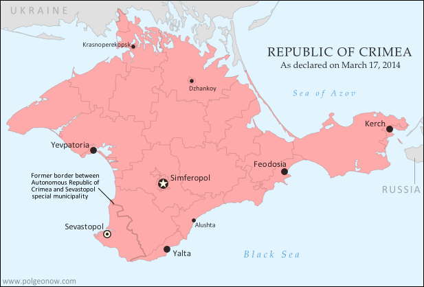
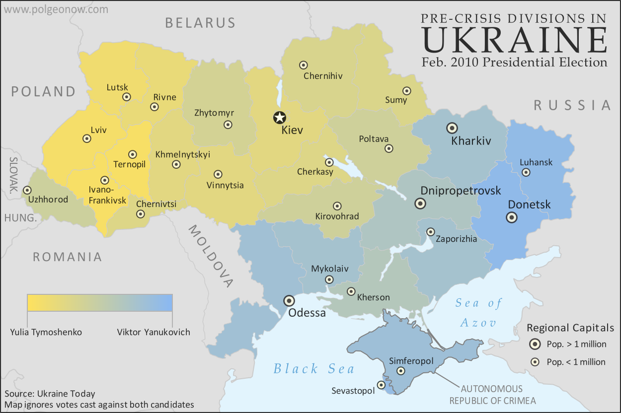
  • Shows the last of the pro-Russian protester occupations, the annexation of Crimea, and seizures by the Ukrainian and Russian militaries outside of Crimea proper
  • Report on the course of events since the last report, explaining each detail shown on the map
  • In-line links to sources of information

Members click here to proceed to article and map

Not a member yet? Subscribe Now!


Thursday, March 27, 2014

Crimea Joins Russia, Gives Up Independence, Becomes Disputed Territory

Premium members click here to view this article in the ad-free members area. Not a member yet? Subscribe now!

Map of the claimed Republic of Crimea, which briefly declared independence from Ukraine on Mar. 17 before being annexed by Russia
The claimed Republic of Crimea which has now joined Russia (click to see full-sized map). By Evan Centanni, based on this blank map.
By Evan Centanni

Russia Annexes Crimea
The Crimean peninsula, which declared independence from Ukraine ten days ago as the Republic of Crimea, has now been absorbed into Russia. This was part of the plan all along - the claimed Republic of Crimea had requested to join Russia at the same time that it declared independence.

Related: Complete Map of Locations Seized by Russia in Crimea (Premium)

Wednesday, March 26, 2014

Premium Map Report: Russian Control of Crimea

Map of Russian seizures and military actions in the Crimea region which it recently annexed from Ukraine.

Download PDF
buy


(Subscribe via Paypal)
After a month of low-level conflict, Russian military control of Crimea appears to be nearly complete. Here's a complete map - to the best of our knowledge - of all locations of Russian seizures and other military actions inside and outside of the Crimea region. This map and article are exclusive premium content, available only to members and for individual purchase. Buy now (US$4.99).

Premium article includes:
  • Exclusive map of Russian seizure and attack locations inside and outside of Crimea
  • Guide to all locations on the map, with brief summary of what has happened at each
  • In-line links to sources of information

Members click here to proceed to article and map

Not a member yet? Subscribe Now!


Tuesday, March 18, 2014

Crimea Declares Independence: Is It Really a Country?

On Monday, two regional governments on the Crimean Peninsula controversially declared their independence from Ukraine as the new Republic of Crimea. While the declaration has been rejected by most of the world community, and Crimea hopes to swiftly unite with Russia, for now it might be considered a de facto sovereign state. Read on for details.

Map of the newly declared independent Republic of Crimea, seceding from Ukraine to join Russia (colorblind accessible).
The Republic of Crimea. Map by Evan Centanni, based on this blank map.
Premium members click here to view this article in the ad-free members area. Not a member yet? Subscribe now!

By Evan Centanni

Declaration of Independence
Following Ukraine's revolution, the explosion of pro-Russian protests in the east, and the subsequent occupation of the Crimean peninsula by Russian forces (see our premium report, Ukraine Map: Occupations, Autonomy, & Invasion), a new independent country has been declared on the coast of the Black Sea.

Saturday, March 15, 2014

Madagascar Un-Suspended from African Union

Map of the African Union, including active and suspended members, updated for the January 2014 reinstatement of Madagascar (colorblind accessible).
The African Union as of March 2014. Map by Evan Centanni, from this blank map by Eric Gaba.
License: CC BY-SA
Premium members click here to view this article in the ad-free members area. Not a member yet? Subscribe now!

Saturday, March 8, 2014

How Sharply Divided is Ukraine, Really? Honest Maps of Language and Elections

There's no question that Ukraine's current crisis arose from major political divisions in the country, and it's true that language is an issue. But some online news websites have sensationalized and exaggerated these divisions through misleading maps. PolGeoNow offers a pair of maps that better communicate the blurriness of the supposed lines between western and eastern Ukraine. 

(For a map of current events from January up to this week, including protester control, government occupations, and the Russian invasion, purchase our premium map of the Ukraine crisis or become a member.)

Map of the results of Ukraine's February 2010 presidential runoff election between Yulia Tymoshenko and Viktor Yanukovich
A more honest map of Ukraine's 2010 presidential election. By Evan Centanni.
Premium members click here to view this article in the ad-free members area. Not a member yet? Subscribe now!

Article by Evan Centanni 

Misleading Ukraine Maps
In January, the Washington Post's Max Fisher wrote a popular map-illustrated blog post about the political and linguistic divisions fueling Ukraine's crisis, then at the height of its pro-Europe protest phase. Later, CNN followed the Post's lead and published a similar set of maps. However, the maps in both articles are designed in a way that makes the divisions look much sharper and more black-and-white than they really are. There's not, as Fisher preposterously claims, "an actual, physical line" splitting Ukraine in half. Instead, there's a gradual shading of mixed populations whose ethnic identities and voting history don't always correlate to the country's current political divisions.

Monday, March 3, 2014

Ukraine Map: Occupations, Autonomy, & Invasion (Premium)

Map of the 2014 Ukraine crisis, before and after the ouster of President Yanukovich, updated to March 3, 2014. Details shown include protester occupations, declarations of autonomy, and Russian invasion.

Download PDF
buy


(Subscribe via Paypal)
PolGeoNow begins our Ukraine coverage with this overview of the political situation from January to the present, both before and after the overthrow of President Viktor Yanukovich's government. Details shown include protester occupations, declarations of autonomy, and Russian invasion. This map and article are exclusive premium content, available only to members and for individual purchase. Buy now (US$5.99).

Premium article includes:
  • Exclusive map of the political situation in Ukraine's 2014 crisis
  • Shows protester occupations, regional capitals overrun, autonomy declarations, and locations of Russian military siege
  • Report on the course of events, explaining each detail shown on the map
  • In-line links to sources of information

Members click here to proceed to article and map

Not a member yet? Subscribe Now!


Saturday, February 22, 2014

South Sudan War Map: Current Rebel Control (Update #4) (Premium)

Map of rebel control in South Sudan's ongoing rebellion, showing situation at the time of the ceasefire of January 23, 2014

Download PDF
buy


(Subscribe via Paypal)
This is Part 1 of a double map report on territorial control in South Sudan's ongoing rebellion, available exclusively to premium subscribers or for individual purchase. This map shows current territorial control for late February 2014, including several changes since the time of the ceasefire. Buy now (US$3.99).

To see the map of control at the time of the ceasefire on January 23, see Part 1.

Premium article includes:
  • Exclusive map of current rebel control up to February 21, 2014
  • Multiple changes to territorial control since previous update
  • Several more new locations added to the map
  • Report chronicling changes to territorial control since the ceasefire, including links to sources

Members click here to proceed to article and map

Not a member yet? Subscribe Now!


South Sudan War Map: Control at Time of January Ceasefire (Update #3) (Premium)

Map of rebel control in South Sudan's ongoing rebellion, showing situation at the time of the ceasefire of January 23, 2014

Download PDF
buy


(Subscribe via Paypal)
This is Part 1 of a double map report on territorial control in South Sudan's ongoing rebellion, available exclusively to premium subscribers or for individual purchase. This map shows territorial control as of January 23, when the warring parties signed their ceasefire agreement (including major changes from previous update). Buy now (US$3.99).

To see the map of current control as of late February, go to Part 2.

Premium article includes:
  • Exclusive map of rebel control at the time the ceasefire was signed on January 23, 2014
  • Multiple changes to territorial control since previous update
  • Several new locations added to the map
  • Report chronicling changes to territorial control and describing the situation at the time of the ceasefire, including links to sources

Members click here to proceed to article and map

Not a member yet? Subscribe Now!


Sunday, February 16, 2014

Olympics Map Update: Which Countries Are Attending Sochi 2014?

Map of countries with teams attending the 2014 Winter Olympics in Sochi, Russia, including seven countries making their Winter Olympics debut (highlighted), and one that was suspended but reinstated during the games.
Sochi 2014: Nations attending the Winter Olympics for the first time in bright green; suspended nations reinstated during the games in blue; all other nations attending Sochi 2014 in dark green; ineligible countries/territories in gray. By Evan Centanni, from public domain base map.
Premium members click here to view this article in the ad-free members area. Not a member yet? Subscribe now!

By Evan Centanni

India's Olympics Membership Reinstated
This is a quick update to the map of countries attending the Sochi 2014 Winter Olympics, which originally appeared in Sochi 2014: Which Countries Are (and Aren't) in the Olympics? That article explained that India was not officially included in this year's games due its suspension from the International Olympic Committee (IOC) over a voting issue.

However, on Tuesday India's IOC membership was reinstated, effective immediately. This means that the three Indian athletes at the games, who were allowed to participate independently under the Olympic flag during the opening ceremony and first few days of the event, may now officially represent India again. This is the first time in history that a country has been un-suspended from the the Olympics during the actual games.

Monday, February 10, 2014

Map: Peru & Chile's Sea Dispute Settled in Court

Two weeks ago, the International Court of Justice released a long-awaited ruling on Peru and Chile's disputed maritime boundary. Many headlines claimed that Peru "won" the case, but in fact it was not a full victory for either country. Below is our detailed map of Peru and Chile's seas and of the dispute, followed by an easy-to-understand summary of the case. 

Map of Chile and Peru's territorial waters and exclusive economic zones (EEZ), plus the details of their territorial dispute at sea and disagreement of the land border. Shows the results of the Jan. 27, 2014 ruling by the International Court of Justice (ICJ) settling the dispute.
Map by Evan Centanni (country coastlines and land borders from Natural Earth)
Premium members click here to view this article in the ad-free members area. Not a member yet? Subscribe now!

Article by Evan Centanni


Disputed Territory
Chile and Peru have just settled a decades-long dispute over the location of their maritime boundary (the border between their sea zones). A large wedge of sea off the countries' coast was claimed by both sides, in part because of its high value for the fishing industry. In 2008, Peru took Chile to court over the dispute. Their disagreements would be resolved by the International Court of Justice (ICJ), a United Nations body in the Hague founded for the purpose of settling differences between U.N. member countries.

Friday, February 7, 2014

Sochi 2014: Which Countries Are (and Aren't) in the Olympics?

This is an older version of our Parade of Nations article. Click here to see the newest edition!

[This article was first published in July 2012 as "Parade of Nations: Which Countries Are (and Aren't) in the Olympics?", in connection with that year's Summer Olympics in London. The following article is an updated version for the 2014 Sochi Winter games.]

World map showing the five continental associations of National Olympic Committees, including all nations eligible for the Olympic games
The five continental associations representing the world's Olympic Nations. Gold: Pan-American Sports Organization; Green: European Olympic Committees; Black: Olympic Council of Asia; Red: Oceania National Olympic Committees; Blue: Association of National Olympic Committees of Africa; Gray: non-member country or territory. Map by Evan Centanni, starting from this blank map and modeled after this Wikipedia map.
Premium members click here to view this article in the ad-free members area. Not a member yet? Subscribe now!

The 2014 Winter Olympics in Sochi, Russia officially begin tonight (Feb. 7), and it wouldn't be an Olympic opening ceremony without the Parade of Nations. But how many countries are there in the games, and is everyone included? Read on for an exclusive guide to the roster of Olympic Nations....

Tuesday, January 28, 2014

Syria Civil War Map: January 28, 2014 (#12.1) (Premium)

There are newer versions of this map available. To see them, view all Syria updates.

Map of fighting and territorial control in Syria's Civil War (Free Syrian Army rebels, Kurdish groups, Al-Nusra Front, ISIS/ISIL and others), updated to January 28, 2014. Includes recent locations of conflict between ISIS and other rebel groups, including Raqqa, Jarabulus, Manbij, Kafranbel, and others.

Download PDF
buy


(Subscribe via Paypal)
PolGeoNow presents our first premium Syria map, part of our new more frequent updates for the Syrian Civil War! Since last month a major struggle has emerged between ISIS extremists and a coalition of other rebel groups, with several key towns changing hands. See the updated map and briefing in this premium report. Buy now (US$5.99).

Members click here to proceed to article and map

NOT A MEMBER YET? SUBSCRIBE HERE!


Sunday, January 19, 2014

ICYMI: Cape Verde's Name Change

In the following weeks, PolGeoNow will be publishing several short "in case you missed it (ICYMI)" articles on events from 2013. This is news that we weren't able to cover when it first broke, but that we thought our readers might still want to know about.

Premium members click here to view this article in the ad-free members area. Not a member yet? Subscribe now!

Topographic map of Cape Verde, now known officially as Cabo Verde
Cape Verde, now officially Cabo Verde (click to enlarge). Map by Oona Räisänen/Wikimedia (CC BY-SA) (source).
By Evan Centanni

Cape Verde Changes Official Name
If you read our article on the year 2013 in political geography changes, you've already heard about the change to Cape Verde's official English name. But since keeping track of country name changes is one of the primary missions of Political Geography Now, we are now presenting this in-depth report on the topic.

Thursday, January 16, 2014

South Sudan Rebellion: Map Update 2 (Premium Content)

Map of rebel control in South Sudan's ongoing rebellion, updated to Jan. 16, 2014

Download PDF
buy


(Subscribe via Paypal)
Both peace talks and fighting continue nearly two weeks after our last South Sudan update. In the meantime, there have been several changes to rebel control. The newly updated premium map and report reflect those events, as well as newly available information about other localities. Buy now (US$2.99).

Premium article includes:
  • Exclusive updated map of rebel control in South Sudan's ongoing uprising (current as of January 16, 2014)
  • A number of new localities have been added to the map since last time
  • Report chronicling changes to territorial control since the previous map, with links to sources

Members click here to proceed to article and map

Not a member yet? Subscribe Now!


Sunday, January 12, 2014

Iraq: Map of Al Qaeda Control

There are newer versions of this map available. To see them, view all Iraq updates.

PolGeoNow presents our first map of Iraq, showing control by the government and Al Qaeda rebels in the country's ongoing crisis. Areas of autonomous Kurdish administration in the north are also indicated.

Want to see timely updates for this map? Subscribe to our premium member service!

Map of territorial control in Iraq in January 2014, including cities and countryside held by Al Qaeda (ISIS) as well as areas administered by Kurdistan
Territorial control in Iraq at the beginning of 2014. Map by Evan Centanni, starting from this blank map by German Wikipedia user NordNordWest. License: CC BY-SA
Premium members click here to view this article in the ad-free members area. Not a member yet? Subscribe now!

By Evan Centanni


Al Qaeda in Iraq
Though the reality is of course more complex, power politics in Iraq often revolve around the country's three largest ethnic groups: Shia (Shiite) Arabs, Sunni Arabs, and Kurds (most Kurds are religiously Sunni, but their language and cultural distinguish them from Arabs). Prime Minister Nouri al-Maliki, a Shia Arab, is often accused of manipulating Iraq's democracy to exclusively serve the country's Shia majority. The Kurds govern a highly autonomous region in the northeast, but the Sunni Arabs who dominate northwestern Iraq have relatively little political power. Into the fray has jumped Al Qaeda in Iraq, now part of the Islamic State of Iraq and al-Sham (ISIS) organization which also controls parts of Syria (map). Al Qaeda has waged a fierce campaign against the Iraqi government in the name of Sunnis, though the group is still rejected by many of the people it claims to protect.

Friday, January 3, 2014

South Sudan: Rebel Control Map Update (Premium Content)

There are newer versions of this map available. To see the full list of updates, view all South Sudan articles

Map of rebel control in South Sudan's 2013-2014 political crisis, updated to Jan. 3, 2014

Download PDF
buy


(Subscribe via Paypal)
Since our first map report on rebel control in South Sudan's political crisis, the situation has continued to develop quickly, with several cities and towns changing hands. PolGeoNow now presents an updated map and report exclusively available as premium content for purchase and to our subscribers. Buy now for only US$2.99!

Premium article includes:
  • Exclusive updated map of rebel control in South Sudan's ongoing uprising 
  • Report chronicling changes since the previous map, with links to sources

Members click here to proceed to article and map

Not a member yet? Subscribe Now!