Thursday, April 23, 2020

Libyan Civil War Map & Timeline: GNA Takes Sabratha - April 2020 (Subscription)

SUBSCRIBERS CLICK HERE TO PROCEED TO ARTICLE AND MAP

There are newer versions of this map available. To see them, view all Libya updates.

Research by Djordje Djukic. Map by onestopmap.com, Evan Centanni, and Djordje Djukic.

Subscribe for full access to all conflict map reports!

Libya: Who controls what? A concise, professional map of who controls Libya now (April 2020). Shows detailed territorial control in the Libyan Civil War as of April 22, 2020, including all major parties (Government of National Accord (GNA); Tobruk House of Representatives, General Haftar's Libyan National Army (LNA), and allies; Tuareg and Toubou (Tebu, Tubu) militias in the south; the so-called Islamic State (ISIS/ISIL); and other groups such as the National Salvation Government (NSG)). Includes terrain, major roads, and recent locations of interest including Sabratha, Aziziyah, Al-Watiyah Airbase, Waw an Namus, and more. Colorblind accessible. 
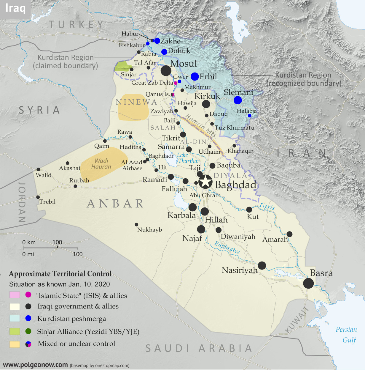
As the fight for Tripoli rages on, Libya's UN-recognized government has captured the city of Sabratha, securing control of the whole coastline west of the capital for the first time in a year.

See all this and more on the latest update to PolGeoNow's concise, professional Libyan Civil War control map, which comes with a timeline of changes since our previous Libya control map report of January 26, 2020.

This map and report are premium content available to paid subscribers of the PolGeoNow Conflict Mapping Service.

Want to see before you subscribe? Check out our most recent FREE SAMPLE Libya map!

Exclusive report includes:
  • Up-to-date map of current territorial control in Libya, color-coded for the UN-backed Government of National Accord (GNA), the rival Tobruk parliament and Khalifa Haftar's Libyan National Army (LNA), the so-called "Islamic State" (ISIS/ISIL), and Toubou and Tuareg militias in the south. Colorblind accessible.
  • Detailed indication of city-by-city control, including key towns and other locations important to current events.
  • Locations of recent fighting and changes of control, including Sabratha, Aziziyah, Al-Watiyah Airbase, Waw an Namus, and more.
  • Detailed timeline of important events and changes to territorial control since January 26, 2020, with links to sources.

SUBSCRIBERS CLICK HERE TO PROCEED TO ARTICLE AND MAP

Not signed up yet? Click here to learn more about our professional subscription service!

Can I purchase just this map?
This map and report are not available for automated purchase to non-subscribers. If you need access or republication rights for only this map report, please contact service@polgeonow.com for options.

Tuesday, April 14, 2020

Schengen Border Controls in the Time of Coronavirus (April 14, 2020)

This map and article have been updated to April 14, 2020. You can also view the previous edition of the map, from March 27, with its accompanying timeline.

Since 2016, PolGeoNow has mapped reinstated border controls within Europe's Schengen free travel area, with the companion piece to this article covering changes from mid-2017 up to last month. Now, border controls between European countries have drastically expanded amid the global coronavirus pandemic. 

Read on for a country-by-country list of border controls and travel bans, plus a timeline of what went into effect when.

Schengen borders map showing temporary reintroduction of border controls in the Schengen Area (the European Union's border-free travel zone) as of April 14, 2020, during the widespread closure of internal Schengen borders due to the COVID-19 coronavirus pandemic. Also includes, in a different color, controls announced by governments where the EU has not been notified.
Map by Evan Centanni, from blank map by Ssolbergj. License: CC BY-SA
Article by Evan Centanni

Coronavirus-related Border Checks in the Schengen Area

As many travelers know, much of Europe is linked together as part of the "Schengen Area", a collection of countries that don't make travelers show any ID to cross the borders between them, and don't regulate what people bring across with them either (although this system is overseen by the European Union, the Schengen Area and the EU aren't the same thing). But under special circumstances, member countries can choose to temporarily resume border checks (also known as "border control").

Monday, April 6, 2020

Map: North Macedonia Joins NATO

Map of NATO allies in 2020, with all members including the newest country to join, North Macedonia (colorblind accessible).


Graphic modified by Evan Centanni from this map by Wikimedia user Addicted04 (CC BY-SA).

New NATO Ally: North Macedonia

Southeastern Europe's Republic of North Macedonia has been admitted as a full member of the North Atlantic Treaty Organization (NATO). Its membership officially went into effect on Friday, March 27, and a welcoming ceremony was held at the organization's headquarters the next Monday. North Macedonia is the 30th country to join NATO.

Membership had been promised to the country in exchange for striking a compromise in its dispute with NATO member Greece, who argued that the neighboring country was falsely claiming ownership of Greek history. Part of the deal, finalized in February 2019, was changing the country's name from "Republic of Macedonia" to "Republic of North Macedonia" - softening the implication that it's the heir to the ancient kingdom of Macedonia, which was mostly located in what's now Greece.

Sunday, March 29, 2020

Yemen Control Map & Report: Houthis Make Key Gains - March 2020 (Subscription)

SUBSCRIBERS CLICK HERE TO PROCEED TO ARTICLE AND MAP

There are newer versions of this map available. To see them, view all Yemen articles on PolGeoNow.

Timeline by Djordje Djukic. Map by Evan Centanni, Djordje Djukic, and onestopmap.com

Map of what's happening in Yemen as of March 2020, including territorial control for the unrecognized Houthi government, president-in-exile Hadi and his allies in the Saudi-led coalition, the UAE-backed southern separatist Southern Transitional Council (STC), and Al Qaeda in the Arabian Peninsula (AQAP). Includes recent locations of fighting and other events, such as Al-Hazm, Yatmah, Shahan, Durayhimi, al-Labanat base, and more.
Subscribe for full access to all conflict map reports!

Since February, Houthi forces have expanded their control in northern Yemen, putting the internationally-backed Hadi government on the defensive, even as the conflict between Hadi and formerly-allied separatists simmers on in the south.

See all this and more on the newest update to PolGeoNow's Yemen territorial control map, which includes a timeline of changes and important events since our previous Yemen map report in February.

This map and report are premium content available to paid subscribers of the PolGeoNow Conflict Mapping Service.

Want to see before you buy? Check out our most recent FREE SAMPLE Yemen map report!

Exclusive report includes:
  • Up-to-date map of current territorial control in Yemen, color-coded for the pro-Hadi coalition, the separatist Southern Transitional Council (STC), Houthi forces, and Al Qaeda in the Arabian Peninsula (AQAP).
  • Detailed indication of town-by-town control, including provincial boundaries, all major cities, and many smaller ones
  • Markers for recent areas of fighting, including Al-Hazm, Yatmah, Shahan, Durayhimi, and more
  • Timeline of changes to the situation since February 16, 2020, with links to sources 

SUBSCRIBERS CLICK HERE TO PROCEED TO ARTICLE AND MAP

Not a member yet? Click here to learn more about our professional subscription service!

Can I purchase just this map?
This map and report are not available for automated purchase to non-subscribers. If you need access or republication rights for only this map report, contact service@polgeonow.com for options.

Friday, March 27, 2020

Schengen Border Controls in the Time of Coronavirus (March 27, 2020)

This is an older edition of our Schengen Area border controls map, preserved here with its accompanying timeline for the historical record. To read the full article and see the current map and country-by-country list of border controls, visit our updated Schengen border controls article.

Schengen borders map showing temporary reintroduction of border controls in the Schengen Area (the European Union's border-free travel zone) as of March 27, 2020, during the widespread closure of internal Schengen borders due to the COVID-19 coronavirus pandemic. Also includes, in a different color, controls announced by governments where the EU has not been notified.
Map by Evan Centanni, from blank map by Ssolbergj. License: CC BY-SA
Article by Evan Centanni

Coronavirus: Schengen Border Controls Timeline March 1-27, 2020

Border controls have proliferated within Europe's "Schengen Area", where there's normally no ID check required to travel from one country to another. For more details, and to see a current map and list country-by-country list of official controls, visit our updated Coronavirus Schengen Border Controls article. Continue reading this article for the timeline of changes to official border controls from the beginning of the COVID-19 outbreak through March 27, as preserved from the previous edition of the article.

Map: Schengen Border Controls Before Coronavirus (2017-2020)

We mapped reinstated border controls within Europe's Schengen free travel area in March 2016, August 2016, February 2017, and August 2017, amid the past half-decade's surge of new refugee and immigrant arrivals. This article chronicles the history of the border checks from 2017 until just before the coronavirus pandemic of 2020. See the companion piece to this article for border controls during the coronavirus outbreak.

Schengen borders map showing temporary reintroduction of border controls in the Schengen Area (the European Union's border-free travel zone) as of February 2020, showing internal Schengen borders closed to passport-free travel just before the surge of new border controls enacted for the coronavirus outbreak. Map is also accurate for most of the period from from late 2019 through early 2020, and similar to the situation in 2018.

Changes to the way France is depicted compared to the previous map represent a stylistic adjustment, and not a change to the actual situation. Map by Evan Centanni, from blank map by Ssolbergj. License: CC BY-SA
Article by Evan Centanni

Border Controls Between Schengen Countries

As anyone who's visited Europe in recent decades knows, much of the continent is linked together as part of the "Schengen Area", a collection of countries that don't make travelers show any ID to cross back and forth across the borders between them - just walk on in (this system is overseen by the European Union, but the Schengen Area and the EU aren't the same thing). Though these borders are supposed to stay unregulated most of the time, the system does allow countries to temporarily reintroduce border controls under certain circumstances.

Map of the Schengen Area, Europe's Border-free Travel Zone

Editor's Note: As of January 2023, the Schengen Area now includes Croatia. The map and article below will soon be updated to reflect this.

What is the "Schengen Area"? What's the difference between Schengen and the EU? And which countries does Schengen include? Read on for all the answers, explained in plain English!

Important note: Though borders within the Schengen Area are normally completely open, countries can sometimes bring back temporary (or even long-term) ID checks. You can check for recent maps of the situation by viewing all Schengen border control articles on PolGeoNow. This is especially true during the 2020 global coronavirus pandemic, when many countries have not only brought back border controls, but are also turning away foreign travelers.

Map of the Schengen Area (the European Union's border-free travel zone), color-coded for EU Schengen countries, non-EU Schengen countries, future Schengen countries, and Schengen-exempt EU countries, as well as microstates unofficially participating in the Schengen agreements. Updated to 2020 for Brexit, removing the UK as a non-Schengen EU member. Colorblind accessible.
Map by Evan Centanni, from blank map by Ssolbergj. License: CC BY-SA

Sunday, March 22, 2020

Syrian Civil War Map & Timeline: New Ceasefire Lines in Northwest - March 2020 (Subscription)

SUBSCRIBERS CLICK HERE TO PROCEED TO ARTICLE AND MAP

There are newer versions of this map available. To see them, view all Syria updates.

Research by Djordje Djukic. Map by onestopmap.com, Evan Centanni, and Djordje Djukic

Subscribe for full access to all conflict map reports!

Map of Syrian Civil War (Syria control map): Territorial control in Syria in March 2020 (Free Syrian Army rebels, Kurdish YPG, Syrian Democratic Forces (SDF), Hayat Tahrir al-Sham (HTS / Al-Nusra Front), Islamic State (ISIS/ISIL), and others). Includes Turkish/TFSA control, joint SDF-Assad control, US deconfliction zone, and Turkey-Russia security corridor, plus recent locations of conflict and territorial control changes, including Kafr Nabl, Nayrab, Anadan, Al Sanamayn, and more. Colorblind accessible. Since last month, Syria's Assad government has gained more ground against the rebels and come into direct conflict with the Turkish military. Now, a deal between Russia and Turkey has brought a new ceasefire to the area.

See all this and more on the latest update to PolGeoNow's concise, professional Syrian Civil War control map, which includes a timeline of changes since our previous Syria map report in February, with sources cited.

This map and report are premium content, available to paid subscribers of the PolGeoNow Conflict Mapping Service.

Want to see before you subscribe? Check out our most recent FREE SAMPLE Syria map!

Exclusive map report includes:
  • Up-to-date illustration of current territorial control in Syria, color-coded for the Assad government, rebel groups, "Islamic State" (ISIS/ISIL) fighters, and the Kurdish-led Syrian Democratic Forces (SDF). Colorblind accessible.
  • Special symbols for joint Turkish/rebel control and joint SDF/government control in the border region
  • Extent of "security corridor" sponsored by Turkey and Russia in the rebel-held northwest
  • Outline showing approximate location of the one publicly-known US "deconfliction zone"
  • Special symbols indicating towns dominated by rebels of the former Al Qaeda Nusra Front (now Hayat Tahrir al-Sham or HTS) and by the Kurdish YPG militia (part of the SDF anti-IS coalition)
  • Detailed indication of city-by-city control, including key towns and other locations important to current events
  • Locations of recent control changes and other important events, including Kafr Nabl, Nayrab, Anadan, Al Sanamayn, and more
  • Detailed timeline of important events and changes to territorial control since February 14, 2020, compiled by our Syria-Iraq expert, with links to sources.

SUBSCRIBERS CLICK HERE TO PROCEED TO ARTICLE AND MAP

Not signed up yet? Click here to learn more about our professional subscription service!

Can I purchase just this map?
This map and report are not available for automated purchase to non-subscribers. If you need access or republication rights for only this map report, contact service@polgeonow.com for options.

Monday, February 17, 2020

Yemen Control Map & Report - February 2020 (Subscription)

SUBSCRIBERS CLICK HERE TO PROCEED TO ARTICLE AND MAP

There are newer versions of this map available. To see them, view all Yemen articles on PolGeoNow.

Timeline by Djordje Djukic. Map by Evan Centanni, Djordje Djukic, and onestopmap.com

Map of what is happening in Yemen as of February 2020, including territorial control for the unrecognized Houthi government, president-in-exile Hadi and his allies in the Saudi-led coalition, the UAE-backed southern separatist Southern Transitional Council (STC), and Al Qaeda in the Arabian Peninsula (AQAP). Includes recent locations of fighting and other events, such as Nihm, Majzar, Yakla, and more.
Subscribe for full access to all conflict map reports!

Over the past two months, the Houthi government has gained some ground in central Yemen against the internationally-backed government of President Hadi, and separatists still hold key towns in the south despite shrinking estimates of their total control.

See all this and more on the newest update to PolGeoNow's Yemen territorial control map, which includes a timeline of changes and important events since our previous Yemen map report in December.

This map and report are premium content available to paid subscribers of the PolGeoNow Conflict Mapping Service.

Want to see before you buy? Check out our most recent FREE SAMPLE Yemen map report!

Exclusive report includes:
  • Up-to-date map of current territorial control in Yemen, color-coded for the pro-Hadi coalition, the separatist Southern Transitional Council (STC), Houthi forces, and Al Qaeda in the Arabian Peninsula (AQAP).
  • Detailed indication of town-by-town control, including provincial boundaries, all major cities, and many smaller ones
  • Markers for recent areas of fighting, including Nihm, Majzar, Yakla, and more
  • Timeline of changes to the situation since December 15, 2019, with links to sources 

SUBSCRIBERS CLICK HERE TO PROCEED TO ARTICLE AND MAP

Not a member yet? Click here to learn more about our professional subscription service!

Can I purchase just this map?
This map and report are not available for automated purchase to non-subscribers. If you need access or republication rights for only this map report, contact service@polgeonow.com for options.

Friday, February 14, 2020

Syrian Civil War Map & Timeline: Assad Retakes Key Highway - February 2020 (Subscription)

SUBSCRIBERS CLICK HERE TO PROCEED TO ARTICLE AND MAP

There are newer versions of this map available. To see them, view all Syria updates.

Research by Djordje Djukic. Map by onestopmap.com, Evan Centanni, and Djordje Djukic

Subscribe for full access to all conflict map reports!

Map of Syrian Civil War (Syria control map): Territorial control in Syria in February 2020 (Free Syrian Army rebels, Kurdish YPG, Syrian Democratic Forces (SDF), Hayat Tahrir al-Sham (HTS / Al-Nusra Front), Islamic State (ISIS/ISIL), and others). Includes Turkish/TFSA control, joint SDF-Assad control, US deconfliction zone, and Turkey-Russia demilitarized buffer zone, plus recent locations of conflict and territorial control changes, including Marat al-Numan, Saraqeb, Regiment 46, Al-Eiss, and more. Colorblind accessible. Over the past month, forces loyal to Syria's Assad government have many major gains in the northwest, capturing two rebel strongholds and reestablishing control along the entire Damascus-Aleppo highway for the first time in eight years.

 See all this and more on the latest update to PolGeoNow's concise, professional Syrian Civil War control map, which includes a timeline of changes since our previous Syria map report in January, with sources cited.

This map and report are premium content, available to paid subscribers of the PolGeoNow Conflict Mapping Service.

Want to see before you subscribe? Check out our most recent FREE SAMPLE Syria map!

Exclusive map report includes:
  • Up-to-date illustration of current territorial control in Syria, color-coded for the Assad government, rebel groups, "Islamic State" (ISIS/ISIL) fighters, and the Kurdish-led Syrian Democratic Forces (SDF). Colorblind accessible.
  • Special symbols for joint Turkish/rebel control and joint SDF/government control in the border region
  • Extent of "buffer zone" sponsored by Turkey and Russia in the rebel-held northwest
  • Outline showing approximate location of the one publicly-known US "deconfliction zone"
  • Special symbols indicating towns dominated by rebels of the former Al Qaeda Nusra Front (now Hayat Tahrir al-Sham or HTS) and by the Kurdish YPG militia (part of the SDF anti-IS coalition)
  • Detailed indication of city-by-city control, including key towns and other locations important to current events
  • Locations of recent control changes and other important events, including Marat al-Numan, Saraqeb, the Regiment 46 base, Al-Eiss, and more
  • Detailed timeline of important events and changes to territorial control since January 20, 2020, compiled by our Syria-Iraq expert, with links to sources.

SUBSCRIBERS CLICK HERE TO PROCEED TO ARTICLE AND MAP

Not signed up yet? Click here to learn more about our professional subscription service!

Can I purchase just this map?
This map and report are not available for automated purchase to non-subscribers. If you need access or republication rights for only this map report, contact service@polgeonow.com for options.

Saturday, February 8, 2020

Brexit: UK Leaves European Union (Plus: What Actually Changed?)

Map of the European Union, including all member countries, official candidate countries, and potential candidate countries, as of February 2020, updated for Brexit - the departure of the UK and Gibraltar (colorblind accessible). Also file under: Map of European Union Member Countries.

Map by Evan Centanni, from blank map by Ssolbergj. License: CC BY-SA

Britain Finally Exits EU

Last week, the United Kingdom of Great Britain and Northern Ireland - "UK" or "Britain" for short - became the first country ever to formally leave the European Union (EU).

This marks the turning point, but not the end, of the years-long saga nicknamed "Brexit" (short for "British exit"), which started with a 2016 referendum.

The long-delayed official exit finally arrived in the first second of February 1, 2020 at the EU headquarters in Belgium. Because of a time zone difference, this was 11:00 pm of January 31 in the UK. But because of a negotiated "transition period", most practical changes won't go into effect until at least the end of this year (read on for more about that).

The British territory of Gibraltar, located along the southern coast of Spain, was also pulled out of the EU alongside the UK.

How it Happened: A Concise Timeline of Brexit

Map of the European Union, including all member countries, official candidate countries, and potential candidate countries, as of February 2020, updated for Brexit - the departure of the UK and Gibraltar (colorblind accessible). Also file under: Map of European Union Member Countries.

Map by Evan Centanni, from blank map by Ssolbergj. License: CC BY-SA

UK Leaves EU: What Were They Doing All That Time?

Last week, the UK actually left the European Union, in a long-anticipated move called for by a referendum vote in 2016. This British exit, or "Brexit" was never meant to happen in less than two years - by how did it stretch out to almost four?

We've put together a clear and concise timeline summarizing the process, without any of the confusing technical lingo or agonizing political details. Enjoy!


Friday, February 7, 2020

Map: Which Countries were in the European Union in 2020, Which Weren't, and Which Wanted to Join?

There are newer versions of this article and map available. You can always find the latest version at this link: Which Countries are in the European Union?

The UK has finally officially left the European Union (EU), almost four years after its famous "Brexit" vote, and taken the British territory of Gibraltar out with it. Here's our updated map and list of which countries are in the EU, which ones are trying to join, and which European countries are in neither group.

Map of the European Union, including all member countries, official candidate countries, and potential candidate countries, as of February 2020, updated for Brexit (colorblind accessible). Also file under: Map of European Union Member Countries.
The European Union after the January 2020 departure of the UK and Gibraltar (pre-Brexit version here).
Map by Evan Centanni, from blank map by Ssolbergj. License: CC BY-SA

Monday, January 27, 2020

Libyan Civil War Map & Timeline: LNA Takes Sirte - January 2020 (Subscription)

SUBSCRIBERS CLICK HERE TO PROCEED TO ARTICLE AND MAP

There are newer versions of this map available. To see them, view all Libya updates.

Research by Djordje Djukic. Map by onestopmap.com, Evan Centanni, and Djordje Djukic.

Subscribe for full access to all conflict map reports!

Libya: Who controls what? A concise, professional map of who controls Libya now (December 2019). Shows detailed territorial control in the Libyan Civil War as of January 26, 2020, including all major parties (Government of National Accord (GNA); Tobruk House of Representatives, General Haftar's Libyan National Army (LNA), and allies; Tuareg and Toubou (Tebu, Tubu) militias in the south; the so-called Islamic State (ISIS/ISIL); and other groups such as the National Salvation Government (NSG)). Includes terrain, major roads, and recent locations of interest including Sirte, Yarmouk Camp, Abu Grain, and more. Colorblind accessible. Since a month ago, the eastern-based Libyan National Army has captured the coastal town of Sirte and reached the doorstep of western-controlled capital Tripoli, even as the western government welcomes reinforcements from the Turkish military and allied Syrian rebels.

See all this and more on the latest update to PolGeoNow's concise, professional Libyan Civil War control map, which comes with a timeline of changes since our previous Libya control map report of December 27, 2019.

This map and report are premium content available to paid subscribers of the PolGeoNow Conflict Mapping Service.

Want to see before you subscribe? Check out our most recent FREE SAMPLE Libya map!

Exclusive report includes:
  • Up-to-date map of current territorial control in Libya, color-coded for the UN-backed Government of National Accord (GNA), the rival Tobruk parliament and Khalifa Haftar's Libyan National Army (LNA), the so-called "Islamic State" (ISIS/ISIL), and Toubou and Tuareg militias in the south. Colorblind accessible.
  • Detailed indication of city-by-city control, including key towns and other locations important to current events.
  • Locations of recent fighting and changes of control, including Sirte, Yarmouk Camp, Abu Grain, and more.
  • Detailed timeline of important events and changes to territorial control since December 27, 2019, with links to sources.

SUBSCRIBERS CLICK HERE TO PROCEED TO ARTICLE AND MAP

Not signed up yet? Click here to learn more about our professional subscription service!

Can I purchase just this map?
This map and report are not available for automated purchase to non-subscribers. If you need access or republication rights for only this map report, please contact service@polgeonow.com for options.

Wednesday, January 22, 2020

Syrian Civil War Map & Timeline - January 2020 (Subscription)

SUBSCRIBERS CLICK HERE TO PROCEED TO ARTICLE AND MAP

There are newer versions of this map available. To see them, view all Syria updates.

Research by Djordje Djukic. Map by onestopmap.com, Evan Centanni, and Djordje Djukic

Subscribe for full access to all conflict map reports!

Map of Syrian Civil War (Syria control map): Territorial control in Syria in January 2020 (Free Syrian Army rebels, Kurdish YPG, Syrian Democratic Forces (SDF), Hayat Tahrir al-Sham (HTS / Al-Nusra Front), Islamic State (ISIS/ISIL), and others). Includes Turkish/TFSA control, joint SDF-Assad control, US deconfliction zone, and Turkey-Russia demilitarized buffer zone, plus recent locations of conflict and territorial control changes, including Marat al-Numan, Al-Hayl Gas Field, Abu Kamal, and more. Colorblind accessible.Since November, Syrian army forces loyal to the Bashar al-Assad government have captured more small parts of the rebel-dominated Idlib province, even as the so-called "Islamic State" (ISIS/ISIL) continues its activities in the eastern desert.

See all this and more on the latest update to PolGeoNow's concise, professional Syrian Civil War control map, which includes a timeline of changes since our previous Syria map report in November, with sources cited.

This map and report are premium content, available to paid subscribers of the PolGeoNow Conflict Mapping Service.

Want to see before you subscribe? Check out our most recent FREE SAMPLE Syria map!

Exclusive map report includes:
  • Up-to-date illustration of current territorial control in Syria, color-coded for the Assad government, rebel groups, "Islamic State" (ISIS/ISIL) fighters, and the Kurdish-led Syrian Democratic Forces (SDF). Colorblind accessible.
  • Special symbols for joint Turkish/rebel control and joint SDF/government control in the border region
  • Extent of "buffer zone" sponsored by Turkey and Russia in the rebel-held northwest
  • Outline showing approximate location of the one publicly-known US "deconfliction zone"
  • Special symbols indicating towns dominated by rebels of the former Al Qaeda Nusra Front (now Hayat Tahrir al-Sham or HTS) and by the Kurdish YPG militia (part of the SDF anti-IS coalition).
  • Detailed indication of city-by-city control, including key towns and other locations important to current events.
  • Locations of recent control changes and other important events, including Ras al-Ayn, Tel Abyad, Ayn Issa, and more.
  • Detailed timeline of important events and changes to territorial control since November 28, 2019, compiled by our Syria-Iraq expert, with links to sources. 

SUBSCRIBERS CLICK HERE TO PROCEED TO ARTICLE AND MAP

Not signed up yet? Click here to learn more about our professional subscription service!

Can I purchase just this map?
This map and report are not available for automated purchase to non-subscribers. If you need access or republication rights for only this map report, contact service@polgeonow.com for options.

Saturday, January 11, 2020

How Many Countries Are There in the World in 2020?

There are newer editions of this article available. To find the most recent, view all "How Many Countries in the World" updates!

This article, originally from 2011, has been revised and updated to January 2020. You can view some older versions of the article in our archives.

How many countries: map of the world
A world political map published by the US government.
One of the most basic questions for map-lovers is, "How many countries are there in the world?" But anyone who just gives you a number isn't telling the whole truth. It actually depends a lot on how you define a "country".

Here are six of the most common answers, each correct in its own way:

Iraq Control Map & Timeline - January 2020

There are newer versions of this map available. To see them, view all Iraq updates.

Iraq Control Map 2020, updated to January 10. Shows areas of Iraq under ISIS control (Islamic State/ISIL/Daesh), and under the control of the Baghdad government, the Kurdistan Peshmerga, and the Yezidi Sinjar Alliance (YBS and YJE). Colorblind accessible.
Basemap by Koen Adams of onestopmap.com, with territorial control by Evan Centanni and Djordje Djukic.
Contact us for permission to use this map.
(Subscribers click here to view this article in the member area)

Timeline by Djordje Djukic, with additional reporting by Evan Centanni

Iraq Map: Who Controls What in 2020

In the nearly two years since our previous Iraq control map update, there have been few major changes to the situation on the ground. But the so-called "Islamic State" (IS; formerly ISIS/ISIL) isn't gone, and recent reports say the group has begun regaining power in the country's north. Tensions have also escalated recently between the US and Iran - both countries are heavily involved in Iraq, and have long competed for influence there. Meanwhile, the self-governed Kurdistan region remains in control of the far north, despite having lost some its claimed territory to the Iraqi central government in the aftermath of its controversial 2017 independence vote.

Tuesday, December 31, 2019

Somalia Control Map & Timeline - December 2019 (Subscription)

SUBSCRIBERS CLICK HERE TO PROCEED TO ARTICLE AND MAP

There are newer versions of this map available. To see them, view all Somalia articles on PolGeoNow.

Map by onestopmap.com, Evan Centanni, and Djordje Djukic

Subscribe for full access to all conflict map reports!

Who controls Somalia? Map (end of 2019). With states, regions, and territorial control. Best Somalia control map online, thoroughly researched, detailed but concise. Shows territorial control by Federal Government of Somalia (FGS), Al Shabaab, so-called Islamic State (ISIS/ISIL), separatist Somaliland, and autonomous states Puntland and Galmudug, plus boundaries of federal states Jubaland, South West, and Hirshabelle. Updated to December 31, 2019. Colorblind accessible.
Since August, pro-federal forces have chipped away a bit at Al Shabaab's still-significant territory in Somalia, while disputes have raged between the federal government and the state administrations of Jubaland and Galmudug. Meanwhile, Al Shabaab claims to have captured a town in northern Somaliland.

See all this and more on the latest update to PolGeoNow's concise, professional Somalia control map, which includes a timeline of changes since our previous Somalia map report of August 2019, with sources cited.

This map and report are premium content, available to paid subscribers of the PolGeoNow Conflict Mapping Service.

Want to see before you subscribe? Check out our most recent FREE SAMPLE Somalia map!

Exclusive map report includes:
  • Up-to-date illustration of current territorial control in Somalia, color-coded for the federal government coalition (including AMISOM peacekeepers), autonomous unionist forces, separatist Somaliland, Al Qaeda affiliate Al Shabaab, and fighters aligned to the so-called "Islamic State" (ISIS/ISIL). Areas of lawlessness or unclear control indicated separately. Colorblind accessible.
  • Boundaries and labels for Somalia's official regions and states, including the autonomous administrations of Somaliland, Puntland, and Galmudug as well as the federally-supported Jubaland, South West, and Hirshabelle states.
  • Detailed indication of city-by-city control, including many relevant smaller towns and villages.
  • Locations of recent fighting and other important events, including Bal'ad, Qayib, Amara, Ga'an Marodi, and more.
  • Detailed timeline of territorial control changes and key political developments since August 13, 2019, with sources cited. 
  • Brief summary of the conflict situation and changes to the map over the past four and a half months.

SUBSCRIBERS CLICK HERE TO PROCEED TO ARTICLE AND MAP

Not signed up yet? Click here to learn more about our professional subscription service!

Saturday, December 28, 2019

Libyan Civil War Map & Timeline - December 2019 (Subscription)

SUBSCRIBERS CLICK HERE TO PROCEED TO ARTICLE AND MAP

There are newer versions of this map available. To see them, view all Libya updates.

Research by Djordje Djukic. Map by onestopmap.com, Evan Centanni, and Djordje Djukic.

Subscribe for full access to all conflict map reports!

Libya: Who controls what? A concise, professional map of who controls Libya now (December 2019). Shows detailed territorial control in the Libyan Civil War as of September 27, 2019, including all major parties (Government of National Accord (GNA); Tobruk House of Representatives, General Haftar's Libyan National Army (LNA), and allies; Tuareg and Toubou (Tebu, Tubu) militias in the south; the so-called Islamic State (ISIS/ISIL); and other groups such as the National Salvation Government (NSG)). Includes terrain, major roads, and recent locations of interest including Yarmouk Camp, Tripoli International Airport, El Feel Oilfield, Tummo border crossing, and more. Colorblind accessible. Since November, forces loyal to Libya's eastern-based government have moved closer to Tripoli's center, where they hope to unseat the country's rival western-based government, even as Turkey prepares a military intervention to defend the government in Tripoli.

See all this and more on the latest update to PolGeoNow's concise, professional Libyan Civil War control map, which comes with a timeline of changes since our previous Libya control map report of November 19, 2019.

This map and report are premium content available to paid subscribers of the PolGeoNow Conflict Mapping Service.

Want to see before you subscribe? Check out our most recent FREE SAMPLE Libya map!

Exclusive report includes:
  • Up-to-date map of current territorial control in Libya, color-coded for the UN-backed Government of National Accord (GNA), the rival Tobruk parliament and Khalifa Haftar's Libyan National Army (LNA), the so-called "Islamic State" (ISIS/ISIL), and Toubou and Tuareg militias in the south. Colorblind accessible.
  • Detailed indication of city-by-city control, including key towns and other locations important to current events.
  • Locations of recent fighting and changes of control, including Yarmouk Camp, Tripoli International Airport, El Feel Oilfield, Tummo border crossing, and more.
  • Detailed timeline of important events and changes to territorial control since November 19, 2019, with links to sources.

SUBSCRIBERS CLICK HERE TO PROCEED TO ARTICLE AND MAP

Not signed up yet? Click here to learn more about our professional subscription service!

Can I purchase just this map?
This map and report are not available for automated purchase to non-subscribers. If you need access or republication rights for only this map report, please contact service@polgeonow.com for options.

Monday, December 16, 2019

Yemen Control Map & Report - December 2019 (Subscription)

SUBSCRIBERS CLICK HERE TO PROCEED TO ARTICLE AND MAP

There are newer versions of this map available. To see them, view all Yemen articles on PolGeoNow.

Timeline by Djordje Djukic. Map by Evan Centanni, Djordje Djukic, and onestopmap.com

Map of what is happening in Yemen as of December 15, 2019, including territorial control for the unrecognized Houthi government, president-in-exile Hadi and his allies in the Saudi-led coalition, the UAE-backed southern separatist Southern Transitional Council (STC), and Al Qaeda in the Arabian Peninsula (AQAP). Includes recent locations of fighting and other events, including Ahwar, Baqim, Malahith, and more.
Subscribe for full access to all conflict map reports!

Over the past two months, separatists seeking an independent South Yemen have held onto control of port city Aden and other towns, despite attempts at reconciliation with the Saudi-backed government of President Hadi. Meanwhile, the rival Houthi government still controls much of the country.

See all this and more on the newest update to PolGeoNow's Yemen territorial control map, which includes a timeline of changes and important events since our previous Yemen map report in October.

This map and report are premium content available to paid subscribers of the PolGeoNow Conflict Mapping Service.

Want to see before you buy? Check out our most recent FREE SAMPLE Yemen map report!

Exclusive report includes:
  • Up-to-date map of current territorial control in Yemen, color-coded for the pro-Hadi coalition, the separatist Southern Transitional Council (STC), Houthi forces, and Al Qaeda in the Arabian Peninsula (AQAP).
  • Detailed indication of town-by-town control, including provincial boundaries, all major cities, and many smaller ones
  • Markers for recent areas of fighting, including Ahwar, Baqim, Malahith, and more
  • Timeline of changes to the situation since October 12, 2019, with links to sources 

SUBSCRIBERS CLICK HERE TO PROCEED TO ARTICLE AND MAP

Not a member yet? Click here to learn more about our professional subscription service!

Can I purchase just this map?
This map and report are not available for automated purchase to non-subscribers. If you need access or republication rights for only this map report, contact service@polgeonow.com for options.