Wednesday, December 11, 2019

Bougainville Votes to Leave Papua New Guinea

Where is Bougainville island located? Map of Bougainville's location within Papua New Guinea.
Bougainville (in red) is currently part of Papua New Guinea.
(modified from a public-domain UN map)

Independence option wins in Bougainville referendum

Three weeks ago we reported on Bougainville's independence referendum - a non-binding vote on whether to split from Papua New Guinea and become a separate country.

After two weeks of voting, the results are finally in: More than 98% of Bougainvilleans have voted in favor of independence.

Saturday, November 30, 2019

Syrian Civil War Map & Timeline - November 2019 (Subscription)

SUBSCRIBERS CLICK HERE TO PROCEED TO ARTICLE AND MAP

There are newer versions of this map available. To see them, view all Syria updates.

Research by Djordje Djukic. Map by onestopmap.com, Evan Centanni, and Djordje Djukic

Subscribe for full access to all conflict map reports!

Map of Syrian Civil War (Syria control map): Territorial control in Syria in November 2019 (Free Syrian Army rebels, Kurdish YPG, Syrian Democratic Forces (SDF), Hayat Tahrir al-Sham (HTS / Al-Nusra Front), Islamic State (ISIS/ISIL), and others). Includes Turkish/TFSA control, joint SDF-Assad control, US deconfliction zone, and Turkey-Russia demilitarized buffer zone, plus recent locations of conflict and territorial control changes, including Ras al-Ayn, Tel Abyad, Ayn Issa, and more. Colorblind accessible. In the past month, Turkey and its allies have further consolidated their chunk of territory in northern Syria, while the Assad-loyal Syrian military has deployed along most of the rest of the border, in line with the Russia-brokered agreement for a "safe zone" free of Kurdish militia fighters.

See all this and more on the latest update to PolGeoNow's concise, professional Syrian Civil War control map, which includes a timeline of changes since our previous Syria map report in October, with sources cited.

This map and report are premium content, available to paid subscribers of the PolGeoNow Conflict Mapping Service.

Want to see before you subscribe? Check out our most recent FREE SAMPLE Syria map!

Exclusive map report includes:
  • NEW: Special symbols for joint Turkish/rebel control and joint SDF/government control, so you can track Turkey's intervention in the border region
  • Up-to-date illustration of current territorial control in Syria, color-coded for the Assad government, rebel groups, "Islamic State" (ISIS/ISIL) fighters, and the Kurdish-led Syrian Democratic Forces (SDF). Colorblind accessible.
  • Extent of "buffer zone" sponsored by Turkey and Russia in the rebel-held northwest
  • Outline showing approximate location of the one publicly-known US "deconfliction zone"
  • Special symbols indicating towns dominated by rebels of the former Al Qaeda Nusra Front (now Hayat Tahrir al-Sham or HTS) and by the Kurdish YPG militia (part of the SDF anti-IS coalition).
  • Detailed indication of city-by-city control, including key towns and other locations important to current events.
  • Locations of recent control changes and other important events, including Ras al-Ayn, Tel Abyad, Ayn Issa, and more.
  • Detailed timeline of important events and changes to territorial control since October 27, 2019, compiled by our Syria-Iraq expert, with links to sources. 

SUBSCRIBERS CLICK HERE TO PROCEED TO ARTICLE AND MAP

Not signed up yet? Click here to learn more about our professional subscription service!

Can I purchase just this map?
This map and report are not available for automated purchase to non-subscribers. If you need access or republication rights for only this map report, contact service@polgeonow.com for options.

Tuesday, November 26, 2019

Ethiopia's Sidama Zone Votes to Become Regional State

Want even more free geography news updates like this one? Help us out by taking a 3-minute survey on our plan to seek funding through optional donations.

Political map of Ethiopia's regional states, highlighting Sidama Zone, which in November 2019 voted to split off from the Southern Nations, Nationalities, and People's Region (SNNPR) to become a new regional state.

Sidama Referendum Passes

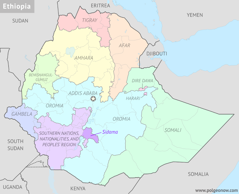
Last week, we reported on a status referendum in southern Ethiopia, where the Sidama Zone was voting on whether to secede from the country's Southern Nations, Nationalities, and Peoples' Region (SNNPR).

Over the weekend, the Ethiopian government announced that the referendum had passed by a very large margin: According to preliminary results, an enormous 98.5% of voters chose increased self-rule. (Voter turnout was also reported to be extremely high, at 99.8%.)

Ethiopia's government has signaled that it plans to respect the result, making the Sidama Zone into the country's tenth self-governing "regional state". This comes despite warnings that Sidama's promotion will supercharge campaigns for statehood in other regions, which could lead to a cascade of mini-secessions that would shake up Ethiopia's administrative structure and politics.

But the Sidama Zone won't become a state immediately - there will likely be a long, contentious process, which requires an amendment to Ethiopia's constitution. One major issue is that the SNNPR's capital city, Hawassa, is located inside the Sidama Zone. If it's going to become the capital of the Sidama Region instead, then the SNNPR will have to find a new capital and move all its government institutions there.

Sidama will become the second-smallest of the Ethiopia's regional states, after the Harari People's National Regional State (the cities of Addis Ababa and Dire Dawa aren't considered regional states, even though they stand separately from the other regions). Its promotion will also create a new state-level exclave - a part of a state that's not connected to the rest of the state - by cutting off the Gedeo Zone to its south from the rest of the SNNPR.

Want to know when these changes actually happen? You'll hear about it here on PolGeoNow!

Wednesday, November 20, 2019

Libya Civil War Map & Timeline - November 2019

There are newer versions of this map available. To see them, view all Libya updates.

Libya civil war map: Who controls what? A concise, professional map of who controls Libya now (November 2019). Shows detailed territorial control in the Libyan Civil War as of September 27, 2019, including all major parties (Government of National Accord (GNA); Tobruk House of Representatives, General Haftar's Libyan National Army (LNA), and allies; Tuareg and Toubou (Tebu, Tubu) militias in the south; the so-called Islamic State (ISIS/ISIL); and other groups such as the National Salvation Government (NSG)). Includes recent locations of interest including Yarmouk Camp, Murzuq, Aziziya, and more. Colorblind accessible.
Base map by Koen Adams of onestopmap.com, with territorial control by Evan Centanni and Djordje Djukic.
Contact us for permission to use this map

(Subscribers click here to view this article in the member area)

Timeline by Djordje Djukic


Map of Libya: Current Situation

In the time since our previous Libya control map update at the end of September, fighting has raged on around the country's capital city of Tripoli between forces loyal to the two main competing governments. The eastern-based Libyan National Army (LNA) has continued to consolidate footholds around the capital, but still hasn't managed to turn the tables enough to capture the city itself from the UN-backed Government of National Accord (GNA). Meanwhile, forces of the so-called "Islamic State" (IS; formerly ISIS/ISIL) are still present in the Libyan desert despite the death of their organization's leader in Syria last month.

Monday, November 18, 2019

Bougainville Voting on Independence from Papua New Guinea

Update: The results are in! Read our Bougainville referendum update to find out what happened!

Bougainville island and its surroundings could become the world's next independent country (public domain UN map).
This week, voting will begin in a referendum that could lead to the creation of the world's first widely-accepted new country in almost a decade. Bougainville, a group of islands in the South Pacific, will be voting on independence from Papua New Guinea.

Where did this come from? Is the referendum expected to pass? Will Bougainville really become independent? Read on for all the answers!

Tuesday, November 5, 2019

Fact Check: Is the AfCFTA the World's Second Biggest Free Trade Area?

African Continental Free Trade Area countries: Map of AfCFTA members and signatories as of October 2019. Who has signed the AfCFTA, who has ratified the AfCFTA, and who has not signed. Updated for 28th ratification by Mauritius. Colorblind accessible.
The AfCFTA is planned to cover almost all of Africa, but doesn't yet.
The recently-created African Continental Free Trade Area (AfCFTA) now has 28 full member countries, with 26 more signed on to the project as future members.

That's a lot of members for a free trade area, and everyone seems to be calling it the "world's biggest free trade area since the WTO". But is that label really accurate?

(If you don't want to read the whole article, scroll down to the conclusion for a short summary.)

Sunday, October 27, 2019

Syrian Civil War Map & Timeline: Turkey Enters Northeast - October 2019 (Subscription)

SUBSCRIBERS CLICK HERE TO PROCEED TO ARTICLE AND MAP

There are newer versions of this map available. To see them, view all Syria updates.

Research by Djordje Djukic. Map by onestopmap.com, Evan Centanni, and Djordje Djukic

Subscribe for full access to all conflict map reports!

Map of Syrian Civil War (Syria control map): Territorial control in Syria in October 2019 (Free Syrian Army rebels, Kurdish YPG, Syrian Democratic Forces (SDF), Hayat Tahrir al-Sham (HTS / Al-Nusra Front), Islamic State (ISIS/ISIL), and others). Includes Turkish control, joint SDF-Assad control, US deconfliction zone, and Turkey-Russia demilitarized buffer zone, plus recent locations of conflict and territorial control changes, including Ras al-Ayn, Tel Abyad, Ayn Issa, and more. Colorblind accessible. Amid a US withdrawal, Turkey and its rebel allies have begun their long-threatened intervention against Kurdish-led fighters in northeastern Syria, who now have struck a deal with the Assad government to share their territory and jointly fight back against Turkey.

See all this and more on the latest update to PolGeoNow's concise, professional Syrian Civil War control map, which includes a timeline of changes since our previous Syria map report in September, with sources cited.

This map and report are premium content, available to paid subscribers of the PolGeoNow Conflict Mapping Service.

Want to see before you subscribe? Check out our most recent FREE SAMPLE Syria map!

Exclusive map report includes:
  • NEW: Special symbols for joint Turkish/rebel control and joint SDF/government control, so you can track Turkey's intervention in the border region
  • EXTRA: Label for Barisha village, where IS leader Abu Bakr al-Baghdadi died in a US raid this weekend
  • Up-to-date illustration of current territorial control in Syria, color-coded for the Assad government, rebel groups, "Islamic State" (ISIS/ISIL) fighters, and the Kurdish-led Syrian Democratic Forces (SDF). Colorblind accessible.
  • Extent of "buffer zone" sponsored by Turkey and Russia in the rebel-held northwest
  • Outline showing approximate location of the one publicly-known US "deconfliction zone"
  • Special symbols indicating towns dominated by rebels of the former Al Qaeda Nusra Front (now Hayat Tahrir al-Sham or HTS) and by the Kurdish YPG militia (part of the SDF anti-IS coalition).
  • Detailed indication of city-by-city control, including key towns and other locations important to current events.
  • Locations of recent control changes and other important events, including Ras al-Ayn, Tel Abyad, Ayn Issa, and more.
  • Detailed timeline of important events and changes to territorial control since September 10, 2019, compiled by our Syria-Iraq expert, with links to sources. 

SUBSCRIBERS CLICK HERE TO PROCEED TO ARTICLE AND MAP

Not signed up yet? Click here to learn more about our professional subscription service!

Can I purchase just this map?
This map and report are not available for automated purchase to non-subscribers. If you need access or republication rights for only this map report, contact service@polgeonow.com for options.

Monday, October 21, 2019

Mauritius Becomes Full Member of AfCFTA (Map)

Update: As far as can be determined, this map is still accurate as of August 2020, with no news on any deposits of ratification instruments since Mauritius. Angola, Cameroon, and Morocco are all reported to have ratified the AfCFTA treaty, but apparently haven't yet completed their membership by registering with African Union headquarters (the AU's official "status list" for the treaty hasn't been updated since October 2019, and recent reports still put the number of deposits at 28). 

In related news, the next stage of the trade area's implementation has been delayed to January 2021, but the organization's headquarters were inaugurated on August 17, 2020 in Accra, Ghana.

African Continental Free Trade Area countries: Map of AfCFTA members and signatories as of October 2019. Who has signed the AfCFTA, who has ratified the AfCFTA, and who has not signed. Updated for 28th ratification by Mauritius. Colorblind accessible.
Map by Evan Centanni, from blank map by Eric Gaba. License: CC BY-SA

Mauritius Ratifies AfCFTA Treaty

Two months ago, we reported on this year's creation of the African Continental Free Trade Area (AfCFTA), an African Union (AU) project to increase trade within Africa. Almost all of Africa's countries have signed on to the AfCFTA, but they only become full members once they've ratified its founding treaty (adopted it into their national laws) and formally registered their ratification with the AU.

Saturday, October 12, 2019

Yemen Control Map & Report - October 2019

There are newer versions of this map available. To see them, view all Yemen articles on PolGeoNow.

Map of what is happening in Yemen as of October 12, 2019, including territorial control for the unrecognized Houthi government, president-in-exile Hadi and his allies in the Saudi-led coalition, the UAE-backed southern separatist Southern Transitional Council (STC), and Al Qaeda in the Arabian Peninsula (AQAP). Includes recent locations of fighting and other events, including Ataq, Mahfad, Al Wadhea, Ketaf, and more.
Map by Evan Centanni and Djordje Djukic, from base map by Koen Adams of onestopmap.com.
Contact us for permission to use this map.
(Subscribers click here to view this article in the member area)

Timeline by Djordje Djukic

Yemen More Divided Than Ever

In the month and a half since our previous Yemen control map report, the separatists of the Southern Transitional Council (STC) have held onto control over much of the country's south, pushing the internationally-recognized Hadi government to abandon Aden and set up a new "interim capital" in the eastern town of Ataq. Meanwhile, fighting between Hadi-loyal forces and the north's rival Houthi government has continued, with both sides capturing territory from each other near the Saudi border.

Tuesday, October 1, 2019

Your Opinion Wanted: Rewards for PolGeoNow Supporters

Conflicto Isla Portillos - mapa 2018. Map of Costa Rica and Nicaragua's post-2015 territorial dispute on Isla Portillos at the mouth of Rio San Juan, showing the judgment of the International Court of Justice (ICJ) of February 2018, based on the case filed in 2017. Includes key features such as Harbor Head Lagoon, the Nicaraguan military camp, the disputed territory along the beach, and the small water channels used to argue Nicaragua's case. Colorblind accessible.
Want more free, original maps like this one of Nicaragua and Costa Rica's territorial dispute? Help us out by taking our super-short survey!
Dear PolGeoNow Readers,

Evan Centanni here - editor and lead cartographer of Political Geography Now. First, I want to say thank you - it's because of readers like that PolGeoNow has come so far in the past eight years, and we're looking forward to bringing you many more years of great free maps and articles!

Yes, I'm here to ask you to fill out a very short survey, so if you want to skip straight to that, go ahead:

Reader Survey: Your Opinion on Rewards for PolGeoNow Supporters (3 minutes)

Monday, September 30, 2019

Libyan Civil War Map & Timeline - September 2019 (Subscription)

SUBSCRIBERS CLICK HERE TO PROCEED TO ARTICLE AND MAP

There are newer versions of this map available. To see them, view all Libya updates.

Research by Djordje Djukic. Map by onestopmap.com, Evan Centanni, and Djordje Djukic.

Subscribe for full access to all conflict map reports!

Libya: Who controls what? A concise, professional map of who controls Libya now (September 2019). Shows detailed territorial control in the Libyan Civil War as of September 27, 2019, including all major parties (Government of National Accord (GNA); Tobruk House of Representatives, General Haftar's Libyan National Army (LNA), and allies; Tuareg and Toubou (Tebu, Tubu) militias in the south; the so-called Islamic State (ISIS/ISIL); and other groups such as the National Salvation Government (NSG)). Includes terrain, major roads, and recent locations of interest including Ain Zara, Gharyan, Murzuq, Tripoli International Airport, and more. Colorblind accessible. Since July, fighting for control of capital city Tripoli has largely remained at a stalemate, with each of the country's rival governments losing and the recapturing territory, though there have been some small net changes in control.

See all this and more on the latest update to PolGeoNow's concise, professional Libyan Civil War control map, which comes with a timeline of changes since our previous Libya control map report of July 21, 2019.

This map and report are premium content available to paid subscribers of the PolGeoNow Conflict Mapping Service.

Want to see before you subscribe? Check out our most recent FREE SAMPLE Libya map!

Exclusive report includes:
  • Up-to-date map of current territorial control in Libya, color-coded for the UN-backed Government of National Accord (GNA), the rival Tobruk parliament and Khalifa Haftar's Libyan National Army (LNA), the so-called "Islamic State" (ISIS/ISIL), and Toubou and Tuareg militias in the south. Colorblind accessible.
  • Detailed indication of city-by-city control, including key towns and other locations important to current events.
  • Locations of recent fighting and changes of control, including Murzuq, Ain Zara, Gharyan, Tripoli International Airport, and more.
  • Detailed timeline of important events and changes to territorial control since July 21, 2019, with links to sources.

SUBSCRIBERS CLICK HERE TO PROCEED TO ARTICLE AND MAP

Not signed up yet? Click here to learn more about our professional subscription service!

Can I purchase just this map?
This map and report are not available for automated purchase to non-subscribers. If you need access or republication rights for only this map report, please contact service@polgeonow.com for options.

Monday, September 23, 2019

Taiwan Loses "Recognition" from Two Pacific Allies (Map)

You can always find the latest version of this map, and a list of all related articles, on our Which Countries "Recognize" Taiwan? page.

Map of who recognizes Taiwan (what countries recognize the Republic of China) in September 2019. Marks countries that have cut diplomatic ties with Taiwan (withdrawn recognition) in the last ten years: Kiribati, Solomon Islands, El Salvador, Burkina Faso, the Dominican Republic, Panama, Sao Tome and Principe, and the Gambia. Also answers question: Where is Republic of China located? (Colorblind accessible)
Click to enlarge. By Evan Centanni, modified from public domain blank world map.
Contact us for permission to use this map.

Map: Which Countries "Recognize" Taiwan in 2019?

This map and explainer will be updated whenever there's a change to the list of Taiwan's "diplomatic allies". You can find articles on each change by scrolling to the bottom of this page, or by viewing all Taiwan articles on PolGeoNow.

Map of who recognizes Taiwan (what countries recognize the Republic of China) in September 2019. Marks countries that have cut diplomatic ties with Taiwan (withdrawn recognition) in the last ten years: Kiribati, Solomon Islands, El Salvador, Burkina Faso, the Dominican Republic, Panama, Sao Tome and Principe, and the Gambia. Also answers question: Where is Republic of China located? (Colorblind accessible)
Click to enlarge. By Evan Centanni, modified from public domain blank world map.
Contact us for permission to use this map.

Is Taiwan a Country?

At PolGeoNow we frequently report on self-proclaimed, unrecognized or partially-recognized countries - but Taiwan is a special case. It operates like an independent country today, but has never formally declared independence. Instead, Taiwan and its surrounding islands govern themselves as the "Republic of China" (ROC), under a constitution brought there by a former government of the Chinese mainland.

Thursday, September 12, 2019

Syrian Civil War Map & Timeline - September 2019

There are newer versions of this map available. To see them, view all Syria updates.

Map of Syrian Civil War (Syria control map): Territorial control in Syria in September 2019 (Free Syrian Army rebels, Kurdish YPG, Syrian Democratic Forces (SDF), Hayat Tahrir al-Sham (HTS / Al-Nusra Front), Islamic State (ISIS/ISIL), and others). Includes US deconfliction zone and Turkey-Russia demilitarized buffer zone, plus recent locations of conflict and territorial control changes, including Khan Shaykhun, Kabani, Morek, and more. Colorblind accessible.
Base map by Koen Adams of onestopmap.com, with territorial control by Evan Centanni and Djordje Djukic.
Contact us for permission to use this map.
(Subscribers click here to view this article in the member area)

Timeline by Djordje Djukic

Government Captures Rebel Stronghold in Idlib

In what's been nearly a month since our previous Syria control map update, almost all major activities have been focused around the southern end of rebel-held Idlib province. For the first time, government forces have captured a major town on the rebel side of the of would-be buffer zone set up last year by Turkey and Russia. Meanwhile, possible changes loom in Syria's northeast, where Turkey is pushing the US to set up a "safe zone" to keep the Kurdish-majority YPG militia away from the border.

Thursday, September 5, 2019

Map: Indonesia Makes Plans to Move Capital

Map: Indonesia says it's moving its capital from Jakarta to a new location in Borneo. Map shows old site, approximate new site, former capital on Yogyakarta, and Palangkaraya, which was considered for the location of the new capital but not chosen.

(Based on blank map by Wikipedia user Indon. License: CC BY-SA)

A PolGeoNow News Brief

Here at Political Geography Now, we prioritize reporting on things in the world that have actually changed. But sometimes news about future or possible changes, like Belize and Guatemala going to court over their border dispute, are interesting enough that we want to share them with you sooner. This article represents a new format where we'll be publishing short, to-the-point summaries of those kinds of geography news stories. As always, we encourage you to tell us what you think by leaving a comment on our Twitter or Facebook!

Saturday, August 31, 2019

Yemen Control Map & Report: Separatists Seize South - August 2019 (Subscription)

SUBSCRIBERS CLICK HERE TO PROCEED TO ARTICLE AND MAP

There are newer versions of this map available. To see them, view all Yemen articles on PolGeoNow.

Map of what is happening in Yemen as of August 31, 2019, including territorial control for the unrecognized Houthi government, president-in-exile Hadi and his allies in the Saudi-led coalition, the UAE-backed southern separatist Southern Transitional Council (STC), and Al Qaeda in the Arabian Peninsula (AQAP). Includes recent locations of fighting, including Ataq, Zinjibar, Shuqra, Ketaf, and more. Colorblind accessible.
Subscribe for full access to all conflict map reports!

Timeline by Djordje Djukic. Map by Evan Centanni, Djordje Djukic, and onestopmap.com

In recent weeks, a major new front has broken out in Yemen's civil war, as southern separatists have broken ranks with the Saudi-backed government of President Hadi, seizing control of key areas in the country's south.

See all this and more on the newest update to PolGeoNow's Yemen territorial control map, which includes a timeline of changes and important events since our previous Yemen map report in June. This report also includes a BONUS MAP showing the height of southern separatist control earlier in August.

This map and report are premium content available to paid subscribers of the PolGeoNow Conflict Mapping Service.

Want to see before you buy? Check out our most recent FREE SAMPLE Yemen map report!

Exclusive report includes:
  • Up-to-date map of current territorial control in Yemen, color-coded for the pro-Hadi coalition, the separatist Southern Transitional Council (STC), Houthi forces, and Al Qaeda in the Arabian Peninsula (AQAP).
  • Detailed indication of town-by-town control, including provincial boundaries, all major cities, and many smaller ones
  • Markers for recent areas of fighting, including Shuqra, Ataq, Balhaf, Ketaf, and more
  • Timeline of changes to the situation since June 15, 2019, with links to sources 
  • BONUS MAP showing the height of southern separatist control earlier in August

SUBSCRIBERS CLICK HERE TO PROCEED TO ARTICLE AND MAP

Not a member yet? Click here to learn more about our professional subscription service!

Can I purchase just this map?
This map and report are not available for automated purchase to non-subscribers. If you need access or republication rights for only this map report, contact service@polgeonow.com for options.

Monday, August 26, 2019

Map: What is the African Continental Free Trade Area (AfCFTA)?

There are newer versions of this map available. To see them, view all AfCFTA updates.

African Continental Free Trade Area countries: Map of AfCFTA members and signatories as of August 2019. Who has signed the AfCFTA, who has ratified the AfCFTA, and who has not signed. Colorblind accessible.
Map by Evan Centanni, from blank map by Eric Gaba. License: CC BY-SA

New Trade Bloc: What is the AfCFTA Agreement?

Despite being neighbors, most countries in Africa trade more with other continents than with each other - a peculiar leftover of colonialism that the African Union (AU) has long been looking to change. Last year, the organization's member countries finally came together and agreed on the creation of one of the world's most expansive "free trade areas". The new zone, called the African Continental Free Trade Area (AfCFTA), officially came into being on May 30, 2019, after a minimum threshold of 22 countries confirmed that they had copied its 2018 founding treaty into their national laws (a process called "ratification").

Saturday, August 17, 2019

Syrian Civil War Map & Timeline - August 2019 (Subscription)

SUBSCRIBERS CLICK HERE TO PROCEED TO ARTICLE AND MAP

There are newer versions of this map available. To see them, view all Syria updates.

Research by Djordje Djukic. Map by onestopmap.com, Evan Centanni, and Djordje Djukic

Subscribe for full access to all conflict map reports!

Map of Syrian Civil War (Syria control map): Territorial control in Syria in August 2019 (Free Syrian Army rebels, Kurdish YPG, Syrian Democratic Forces (SDF), Hayat Tahrir al-Sham (HTS / Al-Nusra Front), Islamic State (ISIS/ISIL), and others). Includes US deconfliction zone and Turkey-Russia demilitarized buffer zone, plus recent locations of conflict and territorial control changes, including Khan Shaykhun, Kabani, and more. Colorblind accessible. Over the past month and a half, fighting between rebels and government forces in the northwest has dominated events in Syria. Meanwhile, the so-called "Islamic State" (ISIS/ISIL) remains confined to uninhabited desert areas of central Syria.

See all this and more on the latest update to PolGeoNow's concise, professional Syrian Civil War control map, which includes a timeline of changes since our previous Syria map report in July, with sources cited.

This map and report are premium content, available to paid subscribers of the PolGeoNow Conflict Mapping Service.

Want to see before you subscribe? Check out our most recent FREE SAMPLE Syria map!

Exclusive map report includes:
  • Up-to-date illustration of current territorial control in Syria, color-coded for the Assad government, rebel groups, "Islamic State" (ISIS/ISIL) fighters, and the Kurdish-led Syrian Democratic Forces (SDF). Colorblind accessible.
  • Location of the demilitarized buffer zone sponsored by Turkey and Russia
  • Outline showing the approximate location of the one publicly-known US "deconfliction zone"
  • Special symbols indicating towns dominated by rebels of the former Al Qaeda Nusra Front (now Hayat Tahrir al-Sham or HTS) and by the Kurdish YPG militia (part of the US-backed SDF).
  • Detailed indication of city-by-city control, including key towns and other locations important to current events.
  • Locations of recent control changes and other important events, including Khan Shaykhun, Kabani, and more.
  • Detailed timeline of important events and changes to territorial control since July 1, 2019, compiled by our Syria-Iraq expert, with links to sources. 

SUBSCRIBERS CLICK HERE TO PROCEED TO ARTICLE AND MAP

Not signed up yet? Click here to learn more about our professional subscription service!

Can I purchase just this map?
This map and report are not available for automated purchase to non-subscribers. If you need access or republication rights for only this map report, contact service@polgeonow.com for options.

Tuesday, August 13, 2019

Somalia Control Map & Timeline - August 2019

There are newer versions of this map available. To see them, view all Somalia articles on PolGeoNow.

Who controls Somalia? Map (2019). With states, regions, and territorial control. Best Somalia control map online, thoroughly researched, detailed but concise. Shows territorial control by Federal Government of Somalia (FGS), Al Shabaab, so-called Islamic State (ISIS/ISIL), separatist Somaliland, and autonomous states Puntland, Galmudug, and Khatumo. Also shows boundaries of Jubaland, South West, and Hirshabelle federal states, as well as ares of operation of  anti-Somaliland militias of Khatumo and Colonel Aare. Updated to August 13, 2019. Colorblind accessible.
Base map by Koen Adams of onestopmap.com, with territorial control by Evan Centanni and Djordje Djukic.
Contact us for permission to use this map.
(Subscribers click here to view this article in the member area)

Timeline by Evan Centanni

Mapping Al Shabaab Control

In the nine months since our previous Somalia control map report, the front lines in southern and central Somalia have changed only subtly: Al Shabaab, Somalia's Al Qaeda-affiliated religious hardline movement, has expanded its governance in some rural areas of the country's southwest, but at the same time has been driven out of two more important towns in the densely-populated Shabelle River valley west of Mogadishu. Scroll down for a full timeline of territorial changes and other major military and political events since last November.