Showing posts with label partially recognized. Show all posts

Saturday, March 9, 2024

Israel / Palestine: Map of Control on March 4, 2024 (Subscription)

SUBSCRIBERS CLICK HERE TO VIEW FULL ARTICLE AND MAP:
Old Portal (members.polgeonow.com) | New Portal (controlmaps.polgeonow.com)


(To see more maps in this series, view all Israel articles or Palestine articles on PolGeoNow.)

Map by Evan Centanni, timeline by Djordje Djukic with Evan Centanni

Subscribe for full access to all conflict map reports!

Thumbnail preview of map of who controlled Palestine and Israel's claimed territories on March 4, 2024, four months into the Israeli (IDF) ground invasion of the Gaza Strip, and before the threatened assault on Rafah. Shows both Israeli and Palestinian Authority administration (Fatah and Hamas factions indicated separately). Includes bigger West Bank map (Area A, Area B, and Area C). Map also includes Gaza Strip, Golan Heights, major cities and Israeli settlements, UN peacekeeper deployments (UNIFIL in Lebanon and UNDOF in Syria), no man's land, Golan Heights buffer zone (area of separation, AOS), and Shebaa Farms. New edition also shows so-called Gaza Envelope and Confrontation Line zones, the areas of Israel proper are under the greatest military restrictions. Includes all major cities and various key towns and sites from the news, like Khan Yunis, Jabalia (Jabaliya), Maghazi Refugee Camp, Abasan al-Kabira, Kerem Shalom crossing, Jenin, Tulkarm, and more. Now with improved colorblind accessibility.

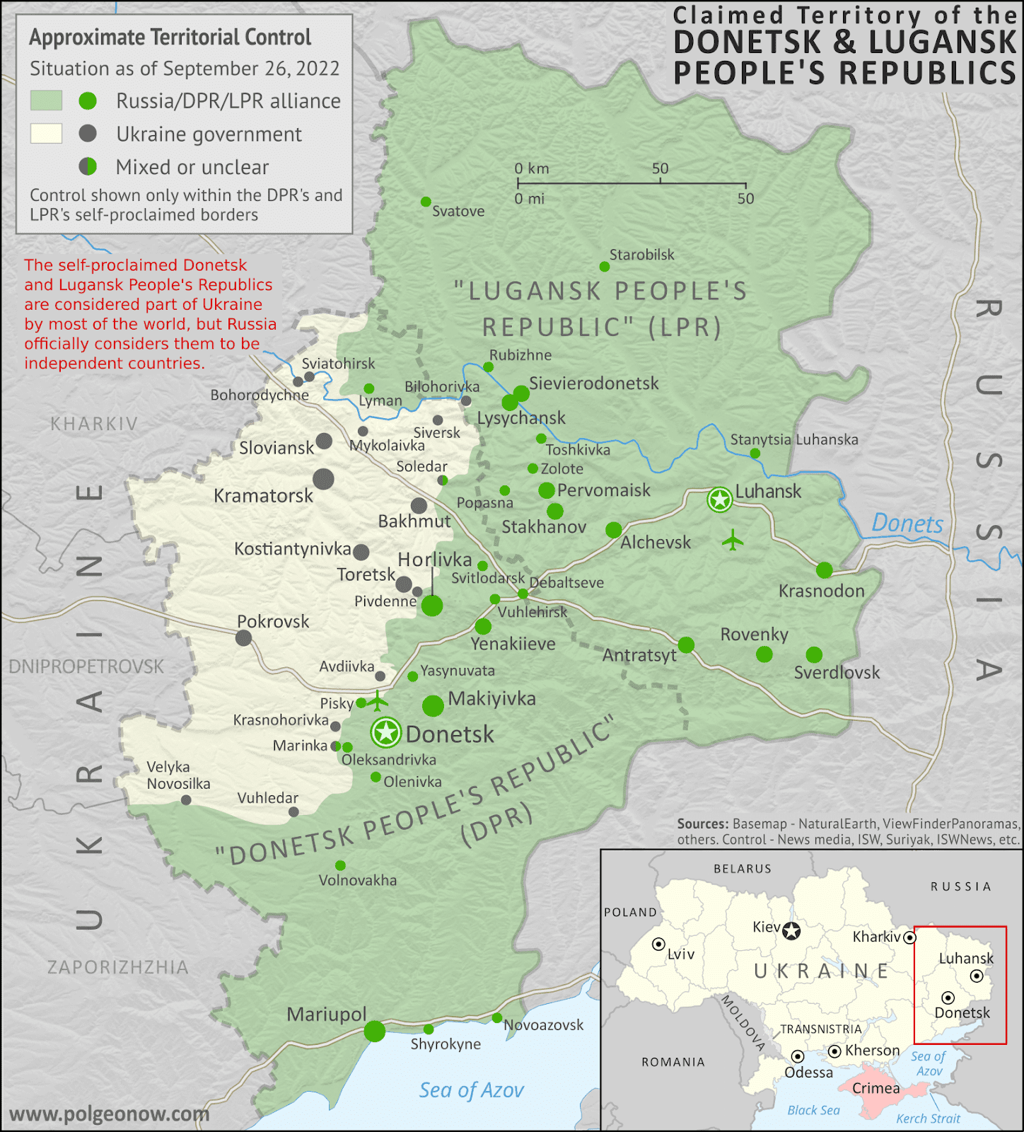
In the past three months, Israel's counter-invasion of the Gaza Strip has slowly ground on, with the shift focusing from Gaza City in the north to Khan Yunis in the south, and possibly to Rafah next. However, much of the Strip still remains outside of Israeli control, while closely-related violence continues at a lower level in the West Bank, on the Lebanon border, and as far afield as Yemen and Iraq.

See all this and more in the latest update to PolGeoNow's widely-acclaimed map of territorial administration in the Israel/Palestine area. In addition to the updated map, the report also includes a detailed chronicle of changes and events since December 8, 2023, the date illustrated by our previous Israel/Palestine control map.

This map and report are premium content, available to paid subscribers of the PolGeoNow Conflict Mapping Service.

Want to see before you subscribe? Check out our most recent FREE SAMPLE Israel/Palestine map report!

Exclusive map report includes:

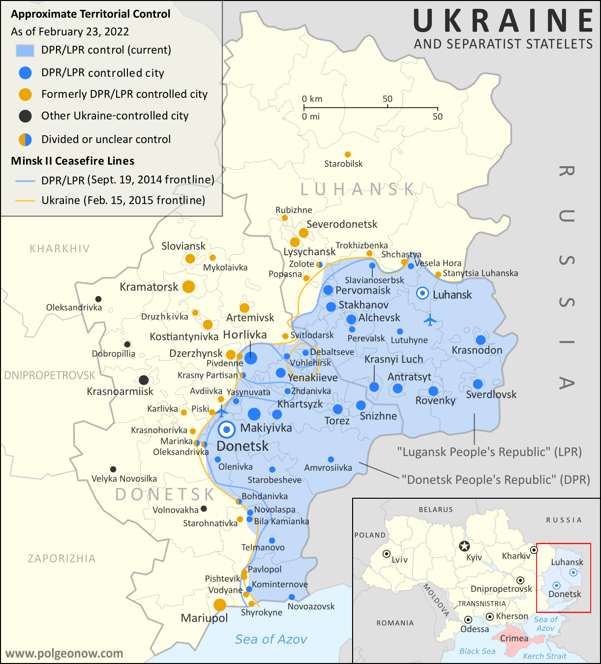
  • Up-to-date illustration of current territorial control across all areas claimed by either Israel or Palestine, including Hamas and Israeli military control in the Gaza Strip (not in extreme detail), as well as UN peacekeeper deployments just outside the region
  • Closer-up inset map showing the divisions in the West Bank: Israeli military control (including Jewish settlements), Fatah-led Palestinian jurisdiction, areas of shared administration, and the (annexed) area of Israeli civilian control in East Jerusalem
  • Lines illustrating the pre-1967 ceasefire boundaries separating Israel proper from the Palestinian-claimed Gaza Strip and West Bank, as well as the Syria-claimed Golan Heights
  • Labels for contentious areas, like the Gaza Strip, West Bank, Golan Heights, Shebaa Farms, and "no man's land"
  • Illustration of which parts of Israel proper are subject to the greatest restrictions by military decree under current war powers: the "Gaza Envelope" in the south and the "Confrontation Line" in the north
  • Detailed indication of city-by-city control, including key towns and other locations important to current events, including in the West Bank and along the border with Israel and Lebanon
  • Locations of recent control changes and other important events, including Khan Yunis, Jabalia (Jabaliya), Maghazi Refugee Camp, Abasan al-Kabira, Kerem Shalom crossing, Jenin, Tulkarm, and more.
  • Detailed timeline of important events and changes to territorial control since December 8, 2023, with links to sources.
  • Additional timeline entries chronicling events in all four additional fronts to the conflict: (1) the Lebanon border, where Israel and Hezbollah are engaged in cross-border attacks; (2) the West Bank, where near-daily Israeli raids on Palestinian-governed cities have led to intense clashes; (3) attacks on Western shipping in the Red Sea and Gulf of Aden near Yemen, where the US and UK have retaliated militarily against the "Houthi" government; and (4) tit-for-tat attacks between Iran-backed militias and the US and Israel in Syria and Iraq (Fronts 3 and 4 are not illustrated on the map).

SUBSCRIBERS CLICK HERE TO VIEW FULL ARTICLE AND MAP:
Old Portal (members.polgeonow.com) | New Portal (controlmaps.polgeonow.com)


Not signed up yet? Click here to learn more about our professional subscription service!

Can I purchase just this map?
This map and report are not available for automated purchase to non-subscribers. If you need access or republication rights for only this map report, contact service@polgeonow.com for options.

Monday, December 11, 2023

Israel / Palestine: Map of Control After End of Truce (December 8, 2023)

Hidden image for crawlersThere are newer editions of this map available. To see them, view all Israel articles or Palestine articles on PolGeoNow. 

This map shows the approximate situation on December 8, a week after Israel and Hamas resumed fighting in the Gaza Strip after a seven-day "humanitarian pause".

Map of who controlled Palestine and Israel's claimed territories early on December 8, 2023, one month into the Israeli (IDF) ground invasion of the Gaza Strip, and a week after the end of the humanitarian pause (ceasefire/truce). Shows both Israeli and Palestinian Authority administration (Fatah and Hamas factions indicated separately). Includes bigger West Bank map (Area A, Area B, and Area C). Map also includes Gaza Strip, Golan Heights, major cities and Israeli settlements, UN peacekeeper deployments (UNIFIL in Lebanon and UNDOF in Syria), no man's land, Golan Heights buffer zone (area of separation, AOS), and Shebaa Farms. Now also shows Israel's closed military zones (closed military areas) and key towns and sites from the news, like Gaza City, Khan Yunis, Beit Hanoun, Jabalia, Erez Crossing, Jenin, and Kiryat Shmona (Qiryat Shemona). Now with improved colorblind accessibility.
Click to enlarge. Map by Evan Centanni, incorporating base map by Koen Adams of onestopmap.com and data from B'Tselem's interactive mapping project. (Contact us for permission to use this map.)

Timeline by Djordje Djukic, with additional reporting by Evan Centanni

Gaza Strip Divided

Just as we were publishing the previous edition of our Israel/Palestine control map, Israel began its long-expected counter-invasion into the Palestinian territory of the Gaza Strip, responding to hardline Palestinian group Hamas's unprecedented October 7 invasion of Israel. Now, one month into Israel's counter-invasion and two months into the war, the densely-populated Gaza Strip is divided between Hamas-led forces and the Israeli military. 

Israeli forces have seized large parts of Gaza City, the biggest population center in the densely-populated Strip, and completely surrounded the parts of it and nearby towns that are still under Hamas control. Meanwhile, since the temporary humanitarian ceasefire between Hamas and Israel ended a week ago, Israel has also pushed deep into the southern Gaza Strip city of Khan Yunis. For more information on control within the Gaza Strip, maps by online conflict-tracker Suriyak and ISW/Critical Threats give good detailed approximations.

Since our last report, Israel's military has appeared to confirm that it's killed at least about 5,000 Palestinian fighters and 10,000 Palestinian civilians, about ten times the respective numbers of Israeli soldiers and civilians killed by Hamas and allies in their brutal October 7 rampage through the Israeli countryside. This is roughly in line with estimates from the Hamas-affiliated Gaza Health Ministry, which as of Friday estimated a total of 17,000 Palestinians killed, about a third of them adult men (who are assumed to make up the vast majority of Hamas fighters).

Saturday, October 28, 2023

Israel / Palestine: Map of Control Before Israel's Gaza Invasion (October 27, 2023)

There are newer editions of this map available. To see them, view all Israel articles or Palestine articles on PolGeoNow.

This map shows the approximate situation early on October 27, 2023, before Israel's announced expansion of military activity within the Gaza Strip. At the time of publication, it's still unclear whether the expected Israeli ground invasion has begun, and little is known of the current situation within the Strip.

Map of who controlled Palestine and Israel's claimed territories early on October 27, 2023, before the expansion of Israeli operations in the Gaza Strip that may signal the start of the expected ground invasion. Shows both Israeli and Palestinian Authority administration (Fatah and Hamas factions indicated separately). Includes bigger West Bank map (Area A, Area B, and Area C). Map also includes Gaza Strip, Golan Heights, major cities and Israeli settlements, UN peacekeeper deployments (UNIFIL in Lebanon and UNDOF in Syria), no man's land, Golan Heights buffer zone (area of separation, AOS), and Shebaa Farms. Now also shows Israel's closed military zones (closed military areas) and key towns and sites from the news, like Sderot, Netivot, Erez Crossing, Rafah, Khan Yunis, Tulkarm, and Kiryat Shmona (Qiryat Shemona). Colorblind accessible.
Click to enlarge. Map by Evan Centanni, incorporating base map by Koen Adams of onestopmap.com and data from B'Tselem's interactive mapping project. (Contact us for permission to use this map.)

Timeline by Djordje Djukic, with additional reporting by Evan Centanni

2023 Israel-Hamas Control Map: Temporary Equilibrium

It's been almost three weeks since Palestinian group Hamas and allies burst unexpectedly out of the Gaza Strip, taking brief but unprecedented control over parts of Israel proper (see our map of the height of Hamas control). Israel's long-promised counter-invasion of the Strip may now be starting, two weeks after its military restored the lines of control to roughly the same as before the Hamas attack. But during the wait, there's been no end to violence: Israel has retaliated against Hamas with heavy bombing of that group's stronghold, the densely-populated Gaza Strip, while both Hamas in Gaza and allied Hezbollah in Lebanon have continued striking Israel with rockets and missiles launched across the borders. 

Israel reports that at least 1,400 of its people have been killed, including over 1,000 civilians - mostly in the first day of Hamas's October 7 invasion - while the Gaza Health Ministry says over 7,000 total Palestinian fighters and civilians have been killed, about 3,000 of them under the age of 18 (the ministry is part of the Hamas-dominated government of the Gaza Strip, but is generally evaluated as credible by outside observers).

Friday, October 13, 2023

Israel / Palestine Map: Height of Hamas Control in 2023 Invasion (October 7, 2023)

There are newer editions of this map available. To see them, view all Israel articles or Palestine articles on PolGeoNow.

This map shows the approximate situation on the afternoon of October 7, 2023, when control by Hamas and its allies reached farthest into Israel. Now, several days later, Israeli forces are thought to have reversed almost all those gains, returning the lines of control to roughly their same positions as just before the invasion.

Map of who controlled Palestine and Israel's claimed territories on the afternoon of October 7, 2023, at the greatest extent of penetration into Israel by the Hamas invasion. Shows both Israeli and Palestinian Authority administration (Fatah and Hamas factions indicated separately). Includes bigger West Bank map (Area A, Area B, and Area C). Map also includes Gaza Strip, Golan Heights, major cities and Israeli settlements, UN peacekeeper deployments (UNIFIL in Lebanon and UNDOF in Syria), no man's land, Golan Heights buffer zone (area of separation, AOS), and Shebaa Farms. Colorblind accessible. Also file under: Map of Hamas attack on Israel.
Click to enlarge. Map by Evan Centanni, incorporating base map by Koen Adams of onestopmap.com and data from B'Tselem's interactive mapping project. (Contact us for permission to use this map.)


Timeline by Djordje Djukic

2023 Israel-Hamas War: How much of Israel did Hamas Capture in its Invasion?

Last Saturday, just a day after the 50th anniversary of Israel's last full-scale war, the country was once again thrust into massive turmoil. In an unprecedented invasion of Israel proper, forces of hardline Palestinian party Hamas and smaller allied groups burst out of their stronghold in the Gaza Strip, briefly doubling their area of control while killing hundreds of Israeli civilians and soldiers alike. The above map shows the approximate situation at the height of Hamas and allied control, later on the same day that the invasion began.

Wednesday, October 11, 2023

Israel / Palestine Map: Who Controlled What Before the 2023 Hamas Invasion?

This article was originally published in July 2020, but has been revised and updated to October 2023. The design of the accompanying map has also been slightly revised, but there were no changes to territorial control between the previous edition and this one except for the reopening of the Gaza fishing zone.

This map shows the situation just before the current war began. For the war itself, check out our new map showing control at the height of the October 2023 Hamas invasion the next day.

Map of who controlled Palestine and Israel's claimed territories on October 6, 2023, just before Hamas's invasion and the start of the current war. Shows both Israeli and Palestinian Authority administration (Fatah and Hamas factions indicated separately). Includes bigger West Bank map (Area A, Area B, and Area C). Map also includes Gaza Strip, Golan Heights, major cities and Israeli settlements, UN peacekeeper deployments (UNIFIL in Lebanon and UNDOF in Syria), no man's land, Golan Heights buffer zone (area of separation, AOS), and Shebaa Farms. Colorblind accessible. Also file under: Palestine controlled area map, How much of Israel is Palestinian land?
Click to enlarge. Map by Evan Centanni, incorporating base map by Koen Adams of onestopmap.com and data from B'Tselem's interactive mapping project. (Contact us for permission to use this map.)

Israel and Palestine Controlled Areas: Before the War

October 2023's surprise invasion of Israel by Palestinian fighters from the Gaza Strip has catapulted the area back to the top of world headlines, and the situation on the ground is now in flux. But what exactly was the situation just before this new chapter of the conflict started? This newly-revised version of PolGeoNow's Israel/Palestine explainer article answers all your questions about who's who and what the significance of each disputed zone is. 

The accompanying map has also been slightly revised and newly fact-checked to ensure that it shows the situation accurately as of October 6, 2023, the night before the Hamas-led invasion of Israel (the only change to control is that the Gaza Strip fishing zone was apparently open for most of this year, rather than closed as it was at the time of our 2021 update).

Note that this is a map of who actually controls what, not of who claims which areas. And it's definitely not supposed to imply that any particular party should or shouldn't control any particular area. As always, PolGeoNow takes no side in these disputes, and we have done our best to report only the facts.

Wednesday, March 29, 2023

2022: Donetsk & Lugansk People's Republics Stop Claiming Independence

Most of our readers will already have heard of this story last year, but because PolGeoNow is committed to providing a record of all changes to the world's list of countries, and because this aspect of the story hasn't been much discussed, we're still publishing an article about it now. Parts of this article are adapted from our story on Recognition of the Donetsk and Lugansk People's Republics from one year ago.

Map of territorial control within the claimed borders of the self-declared Donetsk People's Republic (DPR) and Lugansk People's Republic (LPR) as of September 26, 2022, a week before they stopped claiming independence after their claimed merger with Russia (annexation). Map shows that all of the LPR, otherwise known as Ukraine's Luhansk province, was under the control of Russian and LPR forces, while Russian and DPR forces controlled over half of the DPR, or Ukraine's Donetsk province, including the major central and southern cities of Donetsk, Horlivka, Makiyivka, and Mariupol. Colorblind accessible.
Actual military/administrative control within the DPR and LPR's claimed borders just before their governments' agreed merger into Russia. This was also roughly their greatest extent of control during the period they claimed to be independent countries, if including territory held by their close ally the Russian military. This map was originally published as part of our subscriber-exclusive September 2022 Ukraine control map report.

Partial Recognition

For eight years, from 2014 to 2022, the so-called Donetsk People's Republic (DPR) and Lugansk People's Republic (LPR) said they were independent countries, despite most of the world considering them to be parts of Ukraine. Then late last year, they stopped claiming independence, instead saying they had now become part of Russia, after Russia controversially agreed to take them in. Read on for the full story, explained in plain English...

How Many Countries Are There in the World in 2023?

This article, originally from 2011, has been revised and updated to March 2023. You can view older versions of the article in our archives. The main update from last year is the so-called Donetsk and Lugansk People's Republics no longer claiming to be independent countries.

How many countries: map of the world
A world political map published by the US government.

One of the most basic questions for map-lovers is "How many countries are there in the world?" But anyone who just gives you a simple number isn't telling the whole truth. It actually depends a lot on how you define a "country". Here are six of the most common answers, each correct in its own way:

Monday, March 28, 2022

Recognition of the Donetsk and Lugansk People's Republics

Map of territorial control and frontlines in the Donbass region of Donetsk and Luhansk, internationally recognized as part of eastern Ukraine but partly controlled by the breakaway Donetsk People's Republic and Lugansk People's Republic. Updated for September 2020, with Minsk ceasefire lines shown. Colorblind accessible.
Areas controlled by the self-proclaimed Donetsk and Lugansk People's Republics just before the Russia's full-scale invasion of Ukraine began. For approximate changes that have happened since, check out our Ukraine control map. (Map by Evan Centanni and Djordje Djukic. Contact us for permission to use this map.)

Donetsk and Lugansk: Unrecognized "Republics"

Though now overshadowed by the war, an important political geography event took place in the days leading up to Russia's invasion of Ukraine, changing some versions of the world's list of countries.

Back in April 2014, the month after Russia-backed separatists in the peninsula of Crimea declared their independence from Ukraine, Russia-backed rebels in Ukraine's eastern provinces of Donetsk and Luhansk also announced that they were forming independent countries: the Donetsk People's Republic (DPR) and Lugansk People's Republic (LPR). ("Luhansk" is the Ukrainian-language spelling of the place name, while "Lugansk" is the Russian-language version.)

But unlike Crimea, which had already been secured by Russia's military, and was quickly absorbed into Russia with the permission of its supposed independent government, Donetsk and Lugansk would remain unrecognized for the next eight years - not officially treated as independent countries by any other country, even Russia.*

How Many Countries Were There in the World in 2022?

There are newer editions of this article available. To find the most recent, view all "How Many Countries in the World" updates! 

This article, originally from 2011, has been revised and updated to March 2022. You can view older versions of the article in our archives. The main update from last year is the promotion of the self-proclaimed Donetsk and Lugansk People's Republics from unrecognized to partially-recognized "de facto states".

How many countries: map of the world
A world political map published by the US government.

One of the most basic questions for map-lovers is "How many countries are there in the world?" But anyone who just gives you a simple number isn't telling the whole truth. It actually depends a lot on how you define a "country". Here are six of the most common answers, each correct in its own way:

Friday, May 14, 2021

Israel / Palestine Map: Who Controlled What in May 2021?

This is the 2021 edition of our Israel/Palestine control map, first published in July 2020. A newer version is now available.

Map of who controls Palestine and Israel's claimed territories today (May 14, 2021), as Gaza Strip violence continues to escalate? Israeli and Palestinian Authority administration (Fatah and Hamas factions indicated separately). Also file under: Palestine controlled area map. Includes bigger West Bank map (Areas A, B, C). Map also includes Gaza Strip, Golan Heights, major cities and Israeli settlements, UN peacekeeper deployments (UNIFIL and UNDOF), no man's land, Golan Heights buffer zone (area of separation, AOS), and Shebaa Farms. Colorblind accessible.
Click to enlarge. Map by Evan Centanni, incorporating base map by Koen Adams of onestopmap.com and data from B'Tselem's interactive mapping project. (Contact us for permission to use this map.)

Israel and Palestine Controlled Areas in 2021

The Israeli government's much-hyped plan to absorb parts of the Palestine-claimed West Bank into Israel in 2020 didn't happen (at least not yet). But in May 2021, the region was once again making headlines amid a new wave of fighting. So who actually controlled what parts of Palestine and Israel's claimed territories at the time? This revised version of PolGeoNow's Israel/Palestine control map lays out the details of government jurisdictions on the ground.

There were no changes to the lines of control between 2020 and this 2021 edition, but this edition of the map did feature several modifications for improved clarity and more precise depictions of the situation. If you see something you don't understand on the map, check out the latest edition of our concise outline explaining who's who and introducing each of the disputed areas.

Note that this is a map of who actually controls what, not of who claims which areas. And it's definitely not supposed to imply that any particular party should or shouldn't control any particular area. As always, PolGeoNow takes no side in these disputes, and we have done our best to report only the facts.

Newer Map and Explainer Article: Who Controls What in the Israel-Palestine conflict?

Tuesday, February 2, 2021

How Many Countries Were There in the World in 2021?

There are newer editions of this article available. To find the most recent, view all "How Many Countries in the World" updates!

This article, originally from 2011, has been revised and updated to February 2021. You can view some older versions of the article in our archives. Latest update: Removed the so-called "Islamic State" (ISIS/ISIL) as a "de facto state" candidate.

How many countries: map of the world
A world political map published by the US government.
One of the most basic questions for map-lovers is, "How many countries are there in the world?" But anyone who just gives you a number isn't telling the whole truth. It actually depends a lot on how you define a "country".

Here are six of the most common answers, each correct in its own way:

Wednesday, September 23, 2020

Map & Analysis: Which Countries Recognize Kosovo in 2020?

Announcing the re-launch of our Kosovo recognition updates series! PolGeoNow will now once again be providing timely reports on when countries recognize - or un-recognize - the disputed Republic of Kosovo.

Map of Kosovo recognition, indicating which states (countries) still recognize Kosovo's independence, which have withdrawn recognition, and which claims of recognition have been denied, as of September 2020, including new addition Israel. Colorblind accessible.
Click to enlarge. By Evan Centanni, modified from public domain blank world map.
Contact us for permission to use this map.

Wednesday, July 1, 2020

Israel / Palestine Map: Who Controlled What in 2020?

This is the original version of PolGeoNow's Israel/Palestine administrative control map, as published in July 2020. An improved version is now available as of May 2021 (there have been no changes to the lines of control).

Who controls Palestine and Israel's claimed territories today (June 30, 2020), just before Israel's planned annexation of parts of the West Bank? Also file under: Palestine controlled area map. Includes bigger West Bank map (Areas A, B, C). Map also includes Gaza Strip, Golan Heights, major cities and Israeli settlements, UN peacekeeper deployments (UNIFIL and UNDOF), no man's land, Golan Heights buffer zone (area of separation, AOS), and Shebaa Farms. Colorblind accessible.
Click to enlarge. Map by Evan Centanni, incorporating base map by Koen Adams of onestopmap.com and data from B'Tselem's interactive mapping project. (Contact us for permission to use this map.)

The explanatory article accompanying this map has been revised and updated, and can now be found at the following link: Israel / Palestine Map: Who Controls What in May 2021?

Saturday, January 11, 2020

How Many Countries Are There in the World in 2020?

There are newer editions of this article available. To find the most recent, view all "How Many Countries in the World" updates!

This article, originally from 2011, has been revised and updated to January 2020. You can view some older versions of the article in our archives.

How many countries: map of the world
A world political map published by the US government.
One of the most basic questions for map-lovers is, "How many countries are there in the world?" But anyone who just gives you a number isn't telling the whole truth. It actually depends a lot on how you define a "country".

Here are six of the most common answers, each correct in its own way:

Monday, September 23, 2019

Taiwan Loses "Recognition" from Two Pacific Allies (Map)

You can always find the latest version of this map, and a list of all related articles, on our Which Countries "Recognize" Taiwan? page.

Map of who recognizes Taiwan (what countries recognize the Republic of China) in September 2019. Marks countries that have cut diplomatic ties with Taiwan (withdrawn recognition) in the last ten years: Kiribati, Solomon Islands, El Salvador, Burkina Faso, the Dominican Republic, Panama, Sao Tome and Principe, and the Gambia. Also answers question: Where is Republic of China located? (Colorblind accessible)
Click to enlarge. By Evan Centanni, modified from public domain blank world map.
Contact us for permission to use this map.

Map: Which Countries "Recognize" Taiwan in 2019?

This map and explainer will be updated whenever there's a change to the list of Taiwan's "diplomatic allies". You can find articles on each change by scrolling to the bottom of this page, or by viewing all Taiwan articles on PolGeoNow.

Map of who recognizes Taiwan (what countries recognize the Republic of China) in September 2019. Marks countries that have cut diplomatic ties with Taiwan (withdrawn recognition) in the last ten years: Kiribati, Solomon Islands, El Salvador, Burkina Faso, the Dominican Republic, Panama, Sao Tome and Principe, and the Gambia. Also answers question: Where is Republic of China located? (Colorblind accessible)
Click to enlarge. By Evan Centanni, modified from public domain blank world map.
Contact us for permission to use this map.

Is Taiwan a Country?

At PolGeoNow we frequently report on self-proclaimed, unrecognized or partially-recognized countries - but Taiwan is a special case. It operates like an independent country today, but has never formally declared independence. Instead, Taiwan and its surrounding islands govern themselves as the "Republic of China" (ROC), under a constitution brought there by a former government of the Chinese mainland.

Monday, February 18, 2019

How Many Countries Are There in the World in 2019?

There are newer editions of this article available. To find the most recent, view all "How Many Countries in the World" updates!

How many countries: map of the world
A world political map published by the US government.
One of the most basic questions for map-lovers is, "How many countries are there in the world?" But anyone who just gives you a number isn't telling the whole truth. It actually depends a lot on how you define a "country".

Here are six of the most common answers, each correct in its own way:

Sunday, December 30, 2018

Map: Which Countries Recognized Abkhazia and South Ossetia in 2018?

This is our new, completely redesigned map of which countries consider disputed South Ossetia and Abkhazia to be independent from Georgia. From now on, PolGeoNow will report on any changes to Abkhazian or South Ossetian recognition with updates to this map.

Map of what countries recognize South Ossetia and Abkhazia as independent from Georgia in December 2018. Includes Russia, Nicaragua, Venezuela, Nauru, new recognizer Syria, disputed or withdrawn recognitions from Tuvalu and Vanuatu, and unrecognized countries Transistria, Artsakh (Nagorno-Karabakh), and Western Sahara whose self-proclaimed governments also recognize the so-called Georgian breakaways.(Colorblind accessible)
Click to enlarge. By Evan Centanni, modified from public domain blank world map.
Contact us for permission to use this map.

Tuesday, August 21, 2018

Taiwan Loses "Recognition" from El Salvador (Map)

You can always find the latest version of this map, and a list of all related articles, on our Which Countries Recognize Taiwan? page.

Map of who recognizes Taiwan (what countries recognize the Republic of China) in August 2018. Marks countries that have cut diplomatic ties with Taiwan (withdrawn recognition) in the last ten years: El Salvador, Burkina Faso, the Dominican Republic, Panama, Sao Tome and Principe, and the Gambia. Also answers question: Where is Republic of China located? (Colorblind accessible)
Click to enlarge. By Evan Centanni, modified from public domain blank world map.
Contact us for permission to use this map.

Tuesday, July 31, 2018