Sunday, November 27, 2022

World Cup 2022: Which Countries Are (and Aren't) Members of FIFA?

This is an updated edition of our FIFA member countries article, revised for the Qatar 2022 World Cup. You can also view past versions of the article from 2014 and 2018.

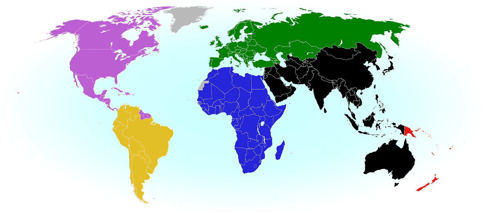
2022 world map showing the six continental confederations of men's national association football (soccer) teams, including all FIFA national teams and World Cup countries. Colorblind accessible.
The six continental confederations of national football teams associated with FIFA. Most, but not all, confederation members are individually members of FIFA as well. Map by Evan Centanni, based on work by EOZyo (source).


Around the world, fans of association football - also known in many countries as "soccer" - are tuned in for the ongoing, month-long men's FIFA World Cup in Qatar. Not all the world's countries can advance to the cup, but did they all get a shot at it? Which countries were eligible to enter the tournament, and which are excluded? Read on for PolGeoNow's exclusive guide to the roster of FIFA national football teams...

Saturday, November 12, 2022

Ukraine: Map of Russian Control Before Kherson Retreat - Nov. 2022 (Subscription)

SUBSCRIBERS CLICK HERE TO VIEW FULL ARTICLE AND MAP:
Old Portal (members.polgeonow.com) | New Portal (controlmaps.polgeonow.com)


There are newer versions of this map available. To see them, view all Ukraine articles on PolGeoNow.

Research by Djordje Djukic. Map by Evan Centanni and Djordje Djukic

Subscribe for full access to all conflict map reports!

Thumbnail previewing map of Russian-controlled territory in Ukraine on November 7, 2022, just before Russia's withdrawal from Kherson city. In addition to the Crimean peninsula, which Russia had already seized in 2014, and parts of the far eastern Donetsk and Luhansk provinces (the Donbas region) already controlled by Russia-backed separatist rebels (and now-formerly declared independent as the Donetsk and Lugansk People's Republics), Russian forces now control a large strip of territory just north of Crimea, including Kherson city and Mariupol, as well as most of Luhansk province and large additional areas of Zaporizhzhia and Donetsk provinces, but have lost most of their territory in Kharkiv province and some of their territory in Luhansk, Donetsk, and Kherson. Map includes key locations from the news, such as Lyman, Kupiansk, Davydiv Brid, Kreminna, the Crimean Bridge, and many more. Colorblind accessible.

(Note: This edition of our Ukraine control map captures the situation in the days prior to Russia's Kherson retreat, while our next report, coming soon, will document the results of the withdrawal itself.)

Despite small gains in Donetsk, Russia and allied forces were already losing major ground in Ukraine prior to this week's Kherson withdrawal. In the month or so leading up to the retreat, Ukraine had already captured significant parts Kherson and Kharkiv provinces, plus bits of Luhansk and other parts of Donetsk.

See all this and more on the latest update to PolGeoNow's concise, professional Ukraine war control map, which includes a detailed chronicle of changes and events since our previous Ukraine map report of September 26, with sources cited, as well as a close-up map of control within the claimed borders of the Donetsk and Lugansk People's Republics (now claimed to be self-governing regions within Russia).

This map and report are premium content, available to paid subscribers of the PolGeoNow Conflict Mapping Service.

Want to see before you subscribe? Check out our most recent FREE SAMPLE Ukraine map!

Exclusive map report includes:

  • Up-to-date illustration of current territorial control in Ukraine, color-coded for the Ukrainian government on one side and the Russian military and allied rebels on the other side, with areas of uncertainty indicated. Colorblind accessible.
  • Darker color indicating which areas were already under Russian or allied control before the 2022 invasion began
  • Lines showing Russia's newly-claimed border after its annexations of Donetsk, Luhansk, Zaporizhzhia, and Kherson provinces.
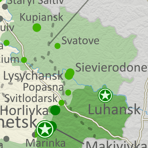
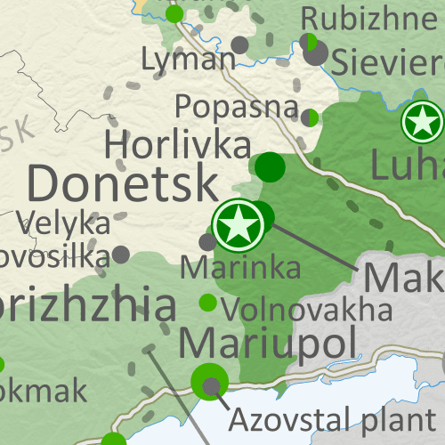
  • Preview thumbnail of map of territorial control within the claimed borders of the self-declared Donetsk People's Republic (DPR) and Lugansk People's Republic (LPR), updated to November 7, 2022, six months into the Russian invasion of Ukraine. Map shows that almost all of the LPR, otherwise known as Ukraine's Luhansk province, is now under the control of Russian and LPR forces, while Russian and DPR forces control over half of the DPR, or Ukraine's Donetsk province, including the major central and southern cities of Donetsk, Horlivka, Makiyivka, and Mariupol. Colorblind accessible.
    Donbas close-up map
    Close-up map of territorial control within the self-proclaimed boundaries of the Donetsk People's Republic and Lugansk People's Republic, which now claim to be part of Russia (based on the design of our classic map of rebel control in the Donbas, upgraded to include roads and terrain)
  • Detailed indication of city-by-city control, including key towns and other locations important to current events
  • Locations of recent control changes and other important events, including Lyman, Kupiansk, Davydiv Brid, Kreminna, the Crimean Bridge, and many more
  • Detailed timeline of important events and changes to territorial control since September 26, 2022, with links to sources.

SUBSCRIBERS CLICK HERE TO VIEW FULL ARTICLE AND MAP:
Old Portal (members.polgeonow.com) | New Portal (controlmaps.polgeonow.com)


Not signed up yet? Click here to learn more about our professional subscription service!

Can I purchase just this map?
This map and report are not available for automated purchase to non-subscribers. If you need access or republication rights for only this map report, contact service@polgeonow.com for options.
Thursday, November 3, 2022

Ethiopia Control Map: Tigray War Revival & New Truce - Nov. 2022 (Subscription)

SUBSCRIBERS CLICK HERE TO VIEW FULL ARTICLE AND MAP:
Old Portal (members.polgeonow.com) | New Portal (controlmaps.polgeonow.com)


(To see other maps of this conflict, view all Ethiopia articles on PolGeoNow.) 

Research by Djordje Djukic. Map by Evan Centanni and Djordje Djukic.

Subscribe for full access to all conflict map reports!

Thumbnail preview of Ethiopia war map for November 2022, at the signing of the new truce, showing Tigray rebel control as well as areas claimed to be controlled by the Oromo Liberation Army (OLA/OLF-Shane) in western and central Ethiopia (Oromia). Also labels key areas in the Benishangul-Gumuz insurgency. Colorblind accessible.

Since the breakdown of Ethiopia's April ceasefire, and with intensified Eritrean involvement, many of the northern state's major towns have come back under the control of the Ethiopian government and its allies. Now, a new truce claims it will bring an end to the Tigray war.

However, the wide-ranging insurgency in Oromia state, and a smaller one in Benishangul Gumuz state, continue elsewhere in the country.

See all this and more on the latest update to PolGeoNow's concise, professional northern Ethiopia control map, which includes a timeline of changes since our previous Ethiopia map report of April 22, with sources cited.


This map and report are premium content, available to paid subscribers of the PolGeoNow Conflict Mapping Service.

Want to see before you subscribe? Check out our most recent FREE SAMPLE Ethiopia map!

Exclusive map report includes:

  • Up-to-date illustration of current territorial control in northern Ethiopia (southern Ethiopia not shown), color-coded for the Ethiopian government and allies on one side and the Tigray Defense Forces (aka TPLF) on the other side, with areas of uncertainty indicated. Colorblind accessible.
  • Symbols showing where Oromo Liberation Army (OLA) rebels (aka OLF-Shane) have plausible - but unproven - claims of territorial control, and labels for important sites in the neighboring Benishangul-Gumuz state insurgency
  • Detailed indication of city-by-city control, including key towns and other locations important to current events
  • Locations of recent control changes and other important events, including Sheraro, Adi Awala, Mai Tsebri, Alamata, Mizyiga, Mandura, and more
  • Detailed timeline of important events and changes to territorial control since April 22, 2022, with links to sources.

SUBSCRIBERS CLICK HERE TO VIEW FULL ARTICLE AND MAP:
Old Portal (members.polgeonow.com) | New Portal (controlmaps.polgeonow.com)


Not signed up yet? Click here to learn more about our professional subscription service!

Can I purchase just this map?
This map and report are not available for automated purchase to non-subscribers. If you need access or republication rights for only this map report, contact service@polgeonow.com for options.

Saturday, October 22, 2022

Armenia-Azerbaijan Control Map: Nagorno-Karabakh & Border Clashes - October 2022 (Subscription)

SUBSCRIBERS CLICK HERE TO VIEW FULL ARTICLE AND MAP:
Old Portal (members.polgeonow.com) | New Portal (controlmaps.polgeonow.com)


(To see more map reports in this series, view all Nagorno-Karabakh articles on PolGeoNow.)

Map by Evan Centanni, Djordje Djukic, Bourrichon, and Lesqual; article by Djordje Djukic and Evan Centanni

Subscribe for full access to all conflict map reports!

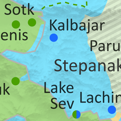
Preview thumbnail of map of territorial control in Azerbaijan and Armenia, including the disputed Nagorno-Karabakh region and the self-proclaimed Republic of Artsakh as well as clashes along the two countries' official border. Updated to October 2022, showing Azerbaijan's apparent territorial incursions into Armenia proper, as well as still-contested sites in Nagorno-Karabakh and the new location of the replacement for the Lachin corridor. Now includes terrain. Colorblind accessible.
Almost two years after the two countries' war ended in a ceasefire, continued clashes have seen Azerbaijan capture several areas apparently within Armenia, while the Russia-enforced corridor from Armenia to Nagorno-Karabakh has moved to a different location.
 
This subscriber-exclusive report goes in-depth on territorial issues and conflict-related developments since our previous Nagorno-Karabakh map report in early 2021, with increased focus on the contested border between Azerbaijan and Armenia proper.

This map and report are premium content, available to paid subscribers of the PolGeoNow Conflict Mapping Service.

Want to see before you subscribe? Check out our most recent FREE SAMPLE Nagorno-Karabakh map!

Exclusive map report includes:

  • Up-to-date illustration of current territorial control in Azerbaijan, Armenia, and the disputed Nagorno-Karabakh region, including the self-proclaimed Republic of Artsakh and the apparent Azerbaijani incursions into Armenia proper. Colorblind accessible. 
  • Claimed borders of the Republic of Artsakh, as well as the former extent of the Soviet-era Nagorno-Karabakh Autonomous Oblast (NKAO).
  • NEW: Terrain shading on map to give a better idea of the physical geography context
  • Key locations of conflict and contention, including Parukh, Lake Sev, Jermuk, Lachin, and more.
  • Detailed timeline of territorial changes and conflict events since January 28, 2021, as well as key military/political developments, with sources cited. 

SUBSCRIBERS CLICK HERE TO VIEW FULL ARTICLE AND MAP:
Old Portal (members.polgeonow.com) | New Portal (controlmaps.polgeonow.com)


Not signed up yet? Click here to learn more about our professional subscription service!

Tuesday, September 27, 2022

Ukraine: Map of Russian Control - September 2022 (Subscription)

SUBSCRIBERS CLICK HERE TO VIEW FULL ARTICLE AND MAP:
Old Portal (members.polgeonow.com) | New Portal (controlmaps.polgeonow.com)


There are newer versions of this map available. To see them, view all Ukraine articles on PolGeoNow.

Research by Djordje Djukic. Map by Evan Centanni and Djordje Djukic

Subscribe for full access to all conflict map reports!

Thumbnail previewing map of Russian-controlled territory in Ukraine on September 26, 2022. In addition to the Crimean peninsula, which Russia had already seized in 2014, and parts of the far eastern Donetsk and Luhansk provinces (the Donbass region) already controlled by Russia-backed separatist rebels (and declared independent as the Donetsk and Lugansk People's Republics), Russian forces now control a large strip of territory just north of Crimea, including Kherson city and parts of Mariupol, as well as all of Luhansk province and large additional areas of Donetsk provinces, but have lost most of their territory in Kharkiv province after a recent Ukrainian offensive. Map includes key locations from the news, such as Izium, Vysokopillia, Lyman, Pisky, Krasnohorivka, and many more. Colorblind accessible. Though slow Russian advances have continued in some areas, recent weeks have also seen a string of major Ukrainian victories, which have pushed Russian forces out of most of the areas they had controlled in Kharkiv province.

See all this and more on the latest update to PolGeoNow's concise, professional Ukraine war control map, which includes a detailed chronicle of changes and events since our previous Ukraine map report of August 22, with sources cited, as well as a close-up map of control within the claimed borders of the Donetsk and Lugansk People's Republics.


This map and report are premium content, available to paid subscribers of the PolGeoNow Conflict Mapping Service.

Want to see before you subscribe? Check out our most recent FREE SAMPLE Ukraine map!

Exclusive map report includes:

  • Up-to-date illustration of current territorial control in Ukraine, color-coded for the Ukrainian government on one side and the Russian military and allied rebels on the other side, with areas of uncertainty indicated. Colorblind accessible.
  • Darker color indicating which areas were already under Russian or allied control before the 2022 invasion began
  • Preview thumbnail of map of territorial control within the claimed borders of the self-declared Donetsk People's Republic (DPR) and Lugansk People's Republic (LPR), updated to September 26, 2022, six months into the Russian invasion of Ukraine. Map shows that all of the LPR, otherwise known as Ukraine's Luhansk province, is now under the control of Russian and LPR forces, while Russian and DPR forces control over half of the DPR, or Ukraine's Donetsk province, including the major central and southern cities of Donetsk, Horlivka, Makiyivka, and Mariupol. Colorblind accessible.
    Donbas close-up map
    Close-up map of territorial control within the self-proclaimed borders of the Donetsk People's Republic and Lugansk People's Republic (based on the design of our classic map of rebel control in the Donbas, upgraded to include roads and terrain)
  • Detailed indication of city-by-city control, including key towns and other locations important to current events
  • Locations of recent control changes and other important events, including Izium, Vysokopillia, Lyman, Pisky, Krasnohorivka, and many more
  • Detailed timeline of important events and changes to territorial control since August 22, 2022, with links to sources.

SUBSCRIBERS CLICK HERE TO VIEW FULL ARTICLE AND MAP:
Old Portal (members.polgeonow.com) | New Portal (controlmaps.polgeonow.com)


Not signed up yet? Click here to learn more about our professional subscription service!

Can I purchase just this map?
This map and report are not available for automated purchase to non-subscribers. If you need access or republication rights for only this map report, contact service@polgeonow.com for options.

Saturday, September 10, 2022

Yemen Control Map & Report: Separatists vs. al-Islah - September 2022

SUBSCRIBERS CLICK HERE TO VIEW FULL ARTICLE AND MAP:
Old Portal (members.polgeonow.com) | New Portal (controlmaps.polgeonow.com)


There are newer versions of this map available. To see them, view all Yemen articles on PolGeoNow.

Timeline by Djordje Djukic. Map by Evan Centanni, Djordje Djukic, and onestopmap.com

Thumbnail preview of map of what's happening in Yemen as of September 2022, showing territorial control in the PLC government infighting between Saudi-backed al-Islah and the UAE-backed STC southern separatists, as well as control by the unrecognized Houthi government and major areas of operations of Al Qaeda in the Arabian Peninsula (AQAP). Includes recent locations of fighting and other events, including Ataq, Shuqra (Shuqrah), Arma, Al Wadhea, al-Abr, and more.
Subscribe for full access to all conflict map reports!

While the ceasefire between the Houthis and Yemen's internationally-recognized PLC unity government continues to hold, a major conflict has broken out within the PLC, with UAE-backed southern separatists and their allies seemingly bent on defeating the Saudi-backed al-Islah religious party once and for all, seizing control of key oil fields along the way.

See all this and more on the newest update to PolGeoNow's Yemen territorial control map, which includes a timeline of changes and important events since our previous Yemen map report in April.

This map and report are premium content available to paid subscribers of the PolGeoNow Conflict Mapping Service.

Want to see before you buy? Check out our most recent FREE SAMPLE Yemen map report!

Exclusive report includes:

  • Up-to-date map of current territorial control in Yemen amid the new outbreak of fighting between factions affiliated to the internationally-recognized government, color-coded for the UAE-backed separatist Southern Transitional Council (STC) and allies, Islah party and other remaining government units, Houthi forces, and major presence of Al Qaeda in the Arabian Peninsula (AQAP)
  • Detailed indication of town-by-town control, including provincial boundaries, all major cities, and many smaller ones
  • Markers for recent areas of fighting, including Ataq, Shuqra, Arma, Al Wadhea, al-Abr, and more
  • Timeline of changes to the situation since April 11, 2022, with links to sources 

SUBSCRIBERS CLICK HERE TO VIEW FULL ARTICLE AND MAP:
Old Portal (members.polgeonow.com) | New Portal (controlmaps.polgeonow.com)


Not a member yet? Click here to learn more about our professional subscription service!

Can I purchase just this map?
This map and report are not available for automated purchase to non-subscribers. If you need access or republication rights for only this map report, contact service@polgeonow.com for options.

Friday, September 9, 2022

King Charles's 15 Countries: The Commonwealth Realms

Did you know the new King Charles III isn't just the King of England and the larger UK, but of 14 other independent countries? If that statement just raises more questions for you, read on for all the answers...

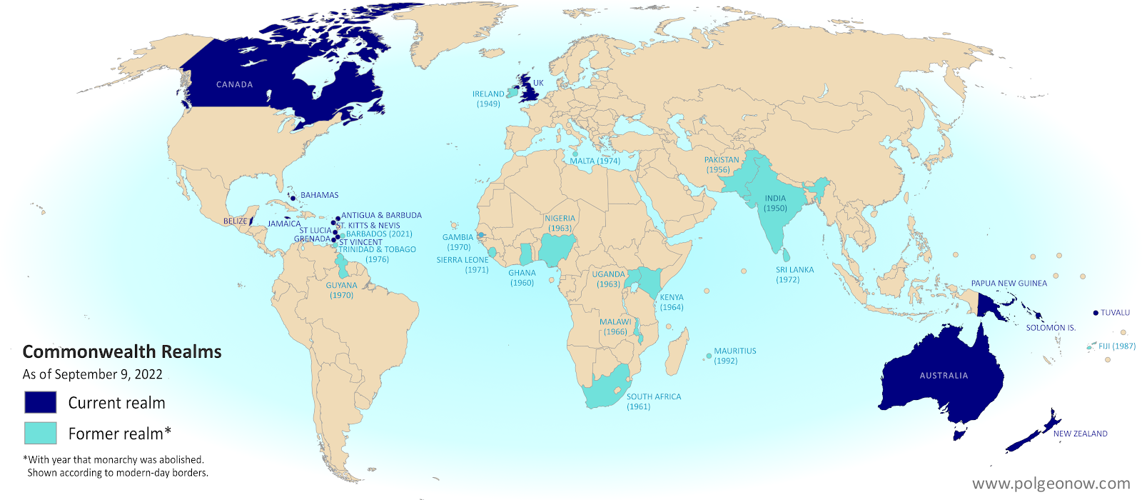
Map of countries with King Charles III as head of state, which are known as the Commonwealth realms. Includes the UK, Canada, Australia, and a number of small countries in Oceania and the Caribbean. Also shows former Commonwealth realms, including large parts of Africa and South Asia. Colorblind accessible.
Map of the Commonwealth realms (independent countries that share the monarchy with Britain). Click to enlarge. Contact us for permission to use this map.


This article, originally written during the reign of Queen Elizabeth II, has been revised and updated to for the passing of the throne to her son, King Charles III.

Which countries does King Charles reign over?

You might be surprised to learn that King Charles III is the official king of 15 different independent countries. Those countries are together known as the "Commonwealth realms" - a smaller subset of the Commonwealth of Nations, which also includes many kingless republics. Every one of the 15 Commonwealth realms is considered a fully-fledged independent country and a member of the UN, despite sharing the same monarch. 

Friday, August 26, 2022

Ukraine: Map of Russian Control - August 2022 (Subscription)

SUBSCRIBERS CLICK HERE TO VIEW FULL ARTICLE AND MAP:
Old Portal (members.polgeonow.com) | New Portal (controlmaps.polgeonow.com)


There are newer versions of this map available. To see them, view all Ukraine articles on PolGeoNow.

Research by Djordje Djukic. Map by Evan Centanni and Djordje Djukic

Subscribe for full access to all conflict map reports!

Thumbnail previewing map of Russian-controlled territory in Ukraine on August 22, 2022. In addition to the Crimean peninsula, which Russia had already seized in 2014, and parts of the far eastern Donetsk and Luhansk provinces (the Donbass region) already controlled by Russia-backed separatist rebels (and declared independent as the Donetsk and Lugansk People's Republics), Russian forces now control a large strip of territory just north of Crimea, including Kherson city and parts of Mariupol, as well as all of Luhansk province and large additional areas of Donetsk and Kharkiv  provinces. Map includes key locations from the news, such as Bakhmut, Marinka, Balakleya, the location of explosions in Crimea, and more. Colorblind accessible. Since last month, Russia and its local allies have continued advances in the east, but at a relatively slow pace. Ukraine's military, meanwhile, has made some smaller advances of its own, but plans to retake Kherson in the south haven't yet materialized.

See all this and more on the latest update to PolGeoNow's concise, professional Ukraine war control map, which includes a detailed chronicle of changes and events since our previous Ukraine map report of July 9, with sources cited, as well as a close-up map of control within the claimed borders of the Donetsk and Lugansk People's Republics.


This map and report are premium content, available to paid subscribers of the PolGeoNow Conflict Mapping Service.

Want to see before you subscribe? Check out our most recent FREE SAMPLE Ukraine map!

Exclusive map report includes:

  • Up-to-date illustration of current territorial control in Ukraine, color-coded for the Ukrainian government on one side and the Russian military and allied rebels on the other side, with areas of uncertainty indicated. Colorblind accessible.
  • Darker color indicating which areas were already under Russian or allied control before the 2022 invasion began
  • Preview thumbnail of map of territorial control within the claimed borders of the self-declared Donetsk People's Republic (DPR) and Lugansk People's Republic (LPR), updated to August 22, 2022, six months into the Russian invasion of Ukraine. Map shows that all of the LPR, otherwise known as Ukraine's Luhansk province, is now under the control of Russian and LPR forces, while Russian and DPR forces control over half of the DPR, or Ukraine's Donetsk province, including the major central and southern cities of Donetsk, Horlivka, Makiyivka, and Mariupol. Colorblind accessible.
    Donbas close-up map
    Close-up map of territorial control within the self-proclaimed borders of the Donetsk People's Republic and Lugansk People's Republic (based on the design of our classic map of rebel control in the Donbas, upgraded to include roads and terrain)
  • Detailed indication of city-by-city control, including key towns and other locations important to current events
  • Locations of recent control changes and other important events, including Bakhmut, Soledar, Siversk, the location of explosions in Crimea, and more
  • Detailed timeline of important events and changes to territorial control since July 9, 2022, with links to sources.

SUBSCRIBERS CLICK HERE TO VIEW FULL ARTICLE AND MAP:
Old Portal (members.polgeonow.com) | New Portal (controlmaps.polgeonow.com)


Not signed up yet? Click here to learn more about our professional subscription service!

Can I purchase just this map?
This map and report are not available for automated purchase to non-subscribers. If you need access or republication rights for only this map report, contact service@polgeonow.com for options.

Saturday, July 16, 2022

Nicaragua v. Colombia: World Court Orders Sea Map Adjustments

Map of Colombia's claimed Integral Contiguous Zone around San Andres, Providencia and its other islands in the Caribbean Sea north of Panama and east of Nicaragua, which was one of the main subjects of dispute with Nicaragua in the Nicaragua v. Colombia World Court case that concluded in April 2022 with a judgement from the International Court of Justice (ICJ) in the Hague. At the center of the map is a large purple blob representing the so-called integral contiguous zone, surrounding each island's 12-mile territorial sea and 24-mile normal contiguous zone and filling the gaps between them. Importantly, this integral contiguous zone overlaps the sea border drawn between Colombia and Nicaragua by the ICJ in 2012. Colorblind accessible.
Modified by PolGeoNow from map included in public court documents (original created by International Mapping).

Latest World Court Ruling: Nicaragua v. Colombia Sea Dispute

Judgments handed down by the UN's International Court of Justice (ICJ) - also known by semi-official nickname "the World Court" - can be pretty interesting to political geography nerds like us. Often they establish new land and sea borders or end long-running territorial disputes, as you might have seen in our past coverage of the Burkina Faso/Niger, Peru v. Chile, Costa Rica v. Nicaragua, and Somalia v. Kenya cases.

Tuesday, July 12, 2022

Ukraine: Map of Russian Control on July 9, 2022 - Luhansk Fully Captured (Subscription)

SUBSCRIBERS CLICK HERE TO VIEW FULL ARTICLE AND MAP:
Old Portal (members.polgeonow.com) | New Portal (controlmaps.polgeonow.com)


There are newer versions of this map available. To see them, view all Ukraine articles on PolGeoNow.

Research by Djordje Djukic. Map by Evan Centanni and Djordje Djukic

Subscribe for full access to all conflict map reports!

Thumbail previewing map of Russian-controlled territory in Ukraine on July 9, 2022). In addition to the Crimean peninsula, which Russia had already seized in 2014, and parts of the far eastern Donetsk and Luhansk provinces (the Donbass region) already controlled by Russia-backed separatist rebels (and declared independent as the Donetsk and Lugansk People's Republics), Russian forces now control a large strip of territory just north of Crimea, including Kherson city and parts of Mariupol, as well as all of Luhansk province and large additional areas of Donetsk and Kharkiv  provinces. Map includes key locations from the news, such as Sievierodonetsk, Lysychansk, Izium, Popasna, Snake Island, and more. Colorblind accessible. In the past month, Russia and its allies from the self-proclaimed Lugansk People's Republic (LPR) have completed their control of the area corresponding to Ukraine's Luhansk province - the first time since 2014 that it hasn't been divided between the Ukrainian government and LPR/Russian control.

See all this and more on the latest update to PolGeoNow's concise, professional Ukraine war control map, which includes a detailed chronicle of changes and events since our previous Ukraine map report of June 13, with sources cited, as well as a close-up map of control within the claimed borders of the Donetsk and Lugansk People's Republics.


This map and report are premium content, available to paid subscribers of the PolGeoNow Conflict Mapping Service.

Want to see before you subscribe? Check out our most recent FREE SAMPLE Ukraine map!

Exclusive map report includes:

  • Up-to-date illustration of current territorial control in Ukraine, color-coded for the Ukrainian government on one side and the Russian military and allied rebels on the other side, with areas of uncertainty indicated. Colorblind accessible.
  • Darker color indicating which areas were already under Russian or allied control before the 2022 invasion began
  • Donbas close-up map
    Close-up map of territorial control within the self-proclaimed borders of the Donetsk People's Republic and Lugansk People's Republic (based on the design of our old map of rebel control in the Donbas)
  • NEW: Donetsk and Lugansk close-up map has been upgraded to include terrain and major rivers and roads
  • Detailed indication of city-by-city control, including key towns and other locations important to current events
  • Locations of recent control changes and other important events, including Sievierodonetsk, Lysychansk, Bilohorivka, Bohorodychne, Snake Island, and more
  • Detailed timeline of important events and changes to territorial control since June 13, 2022, with links to sources.

SUBSCRIBERS CLICK HERE TO VIEW FULL ARTICLE AND MAP:
Old Portal (members.polgeonow.com) | New Portal (controlmaps.polgeonow.com)


Not signed up yet? Click here to learn more about our professional subscription service!

Can I purchase just this map?
This map and report are not available for automated purchase to non-subscribers. If you need access or republication rights for only this map report, contact service@polgeonow.com for options.
Thursday, June 16, 2022

Ukraine: Map of Russian Control on June 13, 2022 (Subscription)

SUBSCRIBERS CLICK HERE TO VIEW FULL ARTICLE AND MAP:
Old Portal (members.polgeonow.com) | New Portal (controlmaps.polgeonow.com)


There are newer versions of this map available. To see them, view all Ukraine articles on PolGeoNow.

Research by Djordje Djukic. Map by Evan Centanni and Djordje Djukic

Subscribe for full access to all conflict map reports!

Thumbail previwing map of Russian-controlled territory in Ukraine on June 13, 2022). In addition to the Crimean peninsula, which Russia had already seized in 2014, and parts of the far eastern Donetsk and Luhansk provinces (the Donbass region) already controlled by Russia-backed separatist rebels (and declared independent as the Donetsk and Lugansk People's Republics), Russian forces control a large strip of territory just north of Crimea, including Kherson city and parts of Mariupol, as well as large additional areas of Donetsk and Luhansk, and other areas of Ukraine's northeast. Ukrainian capital city Kyiv (Kiev) is no longer under siege. Map includes key locations from the news, such as Ternova, Sviatohirsk, Davydiv Brid, the Azot chemical plant in Sievierodonetsk, and more. Colorblind accessible. In recent weeks, Russia and its allies in Donetsk and Luhansk have maintained the upper hand in their fight against Ukraine's government, defending most of the frontlines and nearly completing the capture of Sievierodonetsk, the biggest remaining Ukraine-held city claimed by the self-declared Lugansk People's Republic. 

This update also sees the return of our old map of rebel control in eastern Ukraine, re-imagined as a close-up illustration of remaining Ukrainian control within the claimed borders of the self-proclaimed Donetsk and Lugansk People's Republics.

See all this and more on the latest update to PolGeoNow's concise, professional Ukraine war control map, which includes a timeline of changes since our previous Ukraine map report of May 19, with sources cited.


This map and report are premium content, available to paid subscribers of the PolGeoNow Conflict Mapping Service.

Want to see before you subscribe? Check out our most recent FREE SAMPLE Ukraine map!

Exclusive map report includes:

  • Up-to-date illustration of current territorial control in Ukraine, color-coded for the Ukrainian government on one side and the Russian military and allied rebels on the other side, with areas of uncertainty indicated. Colorblind accessible.
  • Darker color indicating which areas were already under Russian or allied control before the 2022 invasion began
  • NEW: Close-up map of territorial control within the self-proclaimed borders of the Donetsk People's Republic and Lugansk People's Republic (based on the design of our old map of rebel control in the Donbas)
  • Detailed indication of city-by-city control, including key towns and other locations important to current events
  • Locations of recent control changes and other important events, including Ternova, Sviatohirsk, Davydiv Brid, the Azot chemical plant in Sievierodonetsk, and more
  • Detailed timeline of important events and changes to territorial control since May 19, 2022, with links to sources.

SUBSCRIBERS CLICK HERE TO VIEW FULL ARTICLE AND MAP:
Old Portal (members.polgeonow.com) | New Portal (controlmaps.polgeonow.com)


Not signed up yet? Click here to learn more about our professional subscription service!

Can I purchase just this map?
This map and report are not available for automated purchase to non-subscribers. If you need access or republication rights for only this map report, contact service@polgeonow.com for options.
Friday, June 10, 2022

Central African Republic Control Map & Timeline - May 2022 (Subscription)

SUBSCRIBERS CLICK HERE TO VIEW FULL ARTICLE AND MAP:
Old Portal (members.polgeonow.com) | New Portal (controlmaps.polgeonow.com)


(To see other maps of this conflict, view all Central African Republic articles on PolGeoNow.) 

Research by Djordje Djukic, with additional reporting by Evan Centanni. Map by Evan Centanni and Djordje Djukic

Subscribe for full access to all conflict map reports!

Thumbnail preview of Central African Republic conflict: 2021 map of rebel and government control. Updated to June 5, 2022, showing territorial control by the CAR government (with Russian Wagner Group mercenaries and the UN's MINUSCA peacekeeping force), CPC rebel coalition (FPRC, UPC, MPC, 3R),  other ex-Séléka rebels (RPRC, MLCJ), Anti-balaka militias, and other armed groups such as Joseph Kony's Lord's Resistance Army (LRA). Colorblind accessible.

Pro-government forces led by the Russian Wagner Group have accelerated their campaigns in the eastern CAR, carving out new chains of government-held towns deep inside the once-rebel-dominated northeast. Meanwhile, the UPC, perhaps the country's most powerful rebel faction, has rejoined the larger anti-government coalition.

See all this and more on the latest update to PolGeoNow's concise, professional CAR control map, which includes a timeline of changes since our previous CAR map report of July 2021, with sources cited.


This map and report are premium content, available to paid subscribers of the PolGeoNow Conflict Mapping Service.

Want to see before you subscribe? Check out our most recent FREE SAMPLE Central African Republic control map!

Exclusive map report includes:

  • Up-to-date illustration of current territorial control in the Central African Republic, color-coded for the government and allies, the CPC rebel coalition, "Anti-balaka" militias, and other rebel groups, with areas of uncertainty indicated. Colorblind accessible.
  • Detailed indication of city-by-city control, including key towns and other locations important to current events
  • Locations of recent control changes and other important events, including Tiringoulou, Ouanda Djallé, Nzakoundou, Nzacko, Kaita, and more
  • Detailed timeline of important events and changes to territorial control since July 15, 2022, with links to sources.

SUBSCRIBERS CLICK HERE TO VIEW FULL ARTICLE AND MAP:
Old Portal (members.polgeonow.com) | New Portal (controlmaps.polgeonow.com)


Not signed up yet? Click here to learn more about our professional subscription service!

Can I purchase just this map?
This map and report are not available for automated purchase to non-subscribers. If you need access or republication rights for only this map report, contact service@polgeonow.com for options.
Friday, May 20, 2022

Ukraine: Map of Russian Control on May 19, 2022 (Subscription)

SUBSCRIBERS CLICK HERE TO PROCEED TO ARTICLE AND MAP

There are newer versions of this map available. To see them, view all Ukraine articles on PolGeoNow.

Research by Djordje Djukic. Map by Evan Centanni and Djordje Djukic

Subscribe for full access to all conflict map reports!

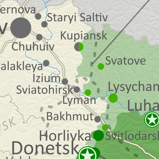
Map of Russian-controlled territory in Ukraine almost three months into the Russian invasion (May 19, 2022). In addition to the Crimean peninsula, which Russia had already seized in 2014, and parts of the far eastern Donetsk and Luhansk provinces (the Donbass region) already controlled by Russia-backed separatist rebels (and declared independent as the Donetsk and Lugansk People's Republics), Russian forces control a large strip of territory just north of Crimea, including Kherson city and parts of Mariupol, as well as large additional areas of Donetsk and Luhansk, and other areas of Ukraine's northeast. Ukrainian capital city Kyiv (Kiev) is no longer under siege. Map includes key locations from the news, such as Popasna, Rubizhne, Bilohorivka, Staryi Saltiv, the Azovstal steel plant in Mariupol, and more. Colorblind accessible. Russia-led forces have nearly surrounded the last Ukraine-held city in Luhansk after capturing two long-contested towns nearby, and have just about completed their control of Mariupol. On the other hand, Ukrainian forces have ended the siege of Kharkiv city in the north, driving Russian forces back towards the border there.

See all this and more on the latest update to PolGeoNow's concise, professional Ukraine war control map, which includes a timeline of changes since our previous Ukraine map report of May 4, with sources cited.


This map and report are premium content, available to paid subscribers of the PolGeoNow Conflict Mapping Service.

Want to see before you subscribe? Check out our most recent FREE SAMPLE Ukraine map!

Exclusive map report includes:

  • Up-to-date illustration of current territorial control in Ukraine, color-coded for the Ukrainian government on one side and the Russian military and allied rebels on the other side, with areas of uncertainty indicated. Colorblind accessible.
  • Darker color indicating which areas were already under Russian or allied control before the 2022 invasion began
  • Claimed borders of the Russia-backed, self-proclaimed Donetsk People's Republic and Lugansk People's Republic in the eastern Donbass region.
  • Detailed indication of city-by-city control, including key towns and other locations important to current events
  • Locations of recent control changes and other important events, including Popasna, Rubizhne, Bilohorivka, Staryi Saltiv, the Azovstal steel plant in Mariupol, and more
  • Detailed timeline of important events and changes to territorial control since May 4, 2022, with links to sources.

SUBSCRIBERS CLICK HERE TO PROCEED TO ARTICLE AND MAP

Not signed up yet? Click here to learn more about our professional subscription service!

Can I purchase just this map?
This map and report are not available for automated purchase to non-subscribers. If you need access or republication rights for only this map report, contact service@polgeonow.com for options.
Thursday, May 5, 2022

Ukraine: Map of Russian Control on May 4, 2022 (Subscription)

SUBSCRIBERS CLICK HERE TO PROCEED TO ARTICLE AND MAP

There are newer versions of this map available. To see them, view all Ukraine articles on PolGeoNow.

Research by Djordje Djukic. Map by Evan Centanni and Djordje Djukic

Subscribe for full access to all conflict map reports!

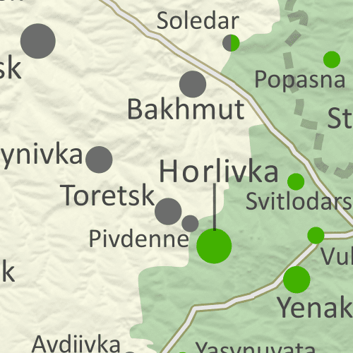
Map of Russian-controlled territory in Ukraine over two months into the Russian invasion (May 4, 2022). In addition to the Crimean peninsula, which Russia had already seized in 2014, and parts of the far eastern Donetsk and Luhansk provinces (the Donbass region) already controlled by Russia-backed separatist rebels (and declared independent as the Donetsk and Lugansk People's Republics), Russian forces control a large strip of territory just north of Crimea, including Kherson city and parts of Mariupol, as well as large additional areas of Donetsk and Luhansk, and other areas of Ukraine's northeast. Ukrainian capital city Kyiv (Kiev) is no longer under siege. Map includes key locations from the news, such as including Izium, Popasna, Rubizhne, the Azovstal steel plant in Mariupol, and more. Colorblind accessible. Recent changes to the map of control in Ukraine have been subtle, with Russia continuing its gradual advance, but Ukrainian forces also recapturing some areas. Ukraine also seems to have begun a campaign of covert attacks across the border into Russia.

See all this and more on the latest update to PolGeoNow's concise, professional Ukraine war control map, which includes a timeline of changes since our previous Ukraine map report of April 18, with sources cited.


This map and report are premium content, available to paid subscribers of the PolGeoNow Conflict Mapping Service.

Want to see before you subscribe? Check out our most recent FREE SAMPLE Ukraine map!

Exclusive map report includes:

  • Up-to-date illustration of current territorial control in Ukraine, color-coded for the Ukrainian government on one side and the Russian military and allied rebels on the other side, with areas of uncertainty indicated. Colorblind accessible.
  • Darker color indicating which areas were already under Russian or allied control before the 2022 invasion began
  • Claimed borders of the Russia-backed, self-proclaimed Donetsk People's Republic and Lugansk People's Republic in the eastern Donbass region.
  • Detailed indication of city-by-city control, including key towns and other locations important to current events
  • Locations of recent control changes and other important events, including Izium, Popasna, Rubizhne, the Azovstal steel plant in Mariupol, and more
  • Detailed timeline of important events and changes to territorial control since April 18, 2022, with links to sources.

SUBSCRIBERS CLICK HERE TO PROCEED TO ARTICLE AND MAP

Not signed up yet? Click here to learn more about our professional subscription service!

Can I purchase just this map?
This map and report are not available for automated purchase to non-subscribers. If you need access or republication rights for only this map report, contact service@polgeonow.com for options.
Monday, May 2, 2022

Ethiopia Control Map: Tigray War on Pause - April 2022 (Subscription)

SUBSCRIBERS CLICK HERE TO PROCEED TO ARTICLE AND MAP

(There are newer versions of this map available. To see them, view all Ethiopia articles on PolGeoNow.)

Research by Djordje Djukic. Map by Evan Centanni and Djordje Djukic

Subscribe for full access to all conflict map reports!

Thumbnail preview of Ethiopia war map for April 2022, showing Tigray rebel control as well as areas claimed to be controlled by the Oromo Liberation Army (OLA/OLF-Shane) in western and central Ethiopia. Colorblind accessible. Since January, Tigray forces have expanded their control a bit farther into neighboring Afar state, before eventually settling into an informal humanitarian truce with the Ethiopian government. Meanwhile, the insurgency in Oromia state continues.

See all this and more on the latest update to PolGeoNow's concise, professional northern Ethiopia control map, which includes a timeline of changes since our previous Ethiopia map report of January 24, with sources cited.


This map and report are premium content, available to paid subscribers of the PolGeoNow Conflict Mapping Service.

Want to see before you subscribe? Check out our most recent FREE SAMPLE Ethiopia map!

Exclusive map report includes:

  • Up-to-date illustration of current territorial control in northern Ethiopia, color-coded for the Ethiopian government and allies on one side and the Tigray Defense Forces (aka TPLF) on the other side, with areas of uncertainty indicated. Colorblind accessible.
  • Symbols showing where Oromo Liberation Army (OLA) rebels (aka OLF-Shane) have plausible - but unproven - claims of territorial control.
  • Detailed indication of city-by-city control, including key towns and other locations important to current events
  • Locations of recent control changes and other important events, including Koba, Berhale, Erebti, Chercher, Gidami, Bandira, and more
  • Detailed timeline of important events and changes to territorial control since January 24, 2022, with links to sources.

SUBSCRIBERS CLICK HERE TO PROCEED TO ARTICLE AND MAP

Not signed up yet? Click here to learn more about our professional subscription service!

Can I purchase just this map?
This map and report are not available for automated purchase to non-subscribers. If you need access or republication rights for only this map report, contact service@polgeonow.com for options.

Tuesday, April 19, 2022

Ukraine: Map of Russian Control on April 18, 2022

There are newer versions of this map available. To see them, view all Ukraine articles on PolGeoNow.
Map of Russian-controlled territory in Ukraine a month and a half into the Russian invasion (April 18, 2022). In addition to the Crimean peninsula, which Russia had already seized in 2014, and parts of the far eastern Donetsk and Luhansk provinces (the Donbass region) already controlled by Russia-backed separatist rebels (and declared independent as the Donetsk and Lugansk People's Republics), Russian forces control a large strip of territory just north of Crimea, including Kherson city and parts of Mariupol, as well as large additional areas of Donetsk and Luhansk, and other areas of Ukraine's northeast. Russia has recently withdrawn from the large area it had captured in north-central Ukraine, including around national capital city Kyiv (Kiev). Map includes key locations from the news, such as Bucha, Mariupol, Izium, Makariv, the Azovstal plant, and many more. Colorblind accessible.
Map by Evan Centanni and Djordje Djukic. Contact us for permission to use this map.

(View this article in the member area)

Timeline by Djordje Djukic

Russia Completes Withdrawal from Northern Ukraine

In the more than two weeks since PolGeoNow's previous Ukraine control map report, Russian forces have completed their withdrawal from north-central Ukraine, and are now beginning a new push to complete their control of the eastern Donbass (Donetsk and Luhansk) region. Fighting this month has largely been focused on the southeastern city of Mariupol, which is now thought to be under full Russian control except for one industrial area. If Russia completes its control there, Mariupol will be the largest city captured since the start of the 2022 invasion.

Tuesday, April 12, 2022

Yemen Control Map & Report: Truce Pauses Fighting - April 2022

There are newer versions of this map available. To see them, view all Yemen articles on PolGeoNow.

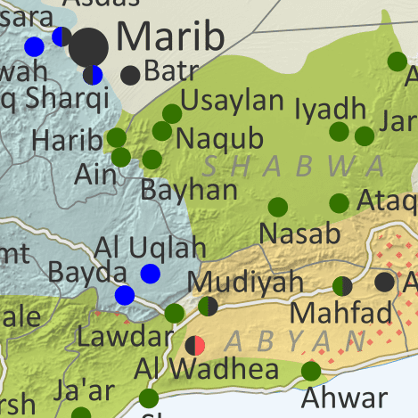
Map of what's happening in Yemen as of April 2022, showing territorial control at the time of the new truce (ceasefire), including the unrecognized Houthi government, the former forces of president-in-exile Hadi (now resigned) and his allies in the Saudi-led coalition, and the UAE-backed southern separatist Southern Transitional Council (STC), plus major areas of operations of Al Qaeda in the Arabian Peninsula (AQAP). Includes recent locations of fighting and other events, including Harib, Harad, Maydee (Midi), Yatmah, and many more.
Map by Evan Centanni and Djordje Djukic, from base map by Koen Adams of onestopmap.com.
Contact us for permission to use this map.

(View this article in the member area)

Timeline by Djordje Djukic, with additional reporting by Evan Centanni

Yemen's New Truce: Who Controls What?

Since our previous Yemen control map report of three months ago, forces of Yemen's unrecognized, Iran-backed Houthi government have rolled back their rivals' recent gains, but still haven't been able to move on the central city of Marib. Amid this stalemate, a surprise UN-brokered truce, alongside the resignation of the country's weak internationally-recognized president, has opened up new possibilities for an end to the war.