Showing posts with label free conflict maps. Show all posts

Friday, August 25, 2017

Somalia Control Map & Timeline - August 2017

This is the first in our new series of Somalia control maps, which includes regular updates for members of our conflict map subscription service

There are newer versions of this map available. To see them, view all Somalia articles on PolGeoNow.

Who controls Somalia? Map (2017). With states, regions, and territorial control. Best Somalia control map online, thoroughly researched and detailed but concise. Shows territorial control by Federal Government of Somalia (FGS), Al Shabaab, so-called Islamic State (ISIS/ISIL), separatist Somaliland, and autonomous states Puntland, Galmudug, Khatumo, and the ASWJ Sufi militia. Updated to of August 25, 2017. Colorblind accessible.
Base map by Koen Adams of onestopmap.com, with territorial control by Djordje Djukic and Evan Centanni. (This graphic has been slightly revised based on newer information. You can see the original version here.)
Contact us for permission to use this map.
(Subscribers click here to view this article in the member area)

Timeline by Djordje Djukic, with additional reporting by Evan Centanni

Mapping Somalia: Who Controls What?

Of all the world's countries, Somalia is probably the most complex in terms of actual territorial control, and also one of the most constantly-changing. Despite that, good control maps for Somalia are hard to find, with major news outlets using simple, hastily-drawn maps (if any), while crowdsourced mapping projects on sites like Wikipedia suffer from a lack of contributors, infrequent updates, and unclear methods. That's why Political Geography Now set out to create the best-designed, most thoroughly-researched Somalia control map online.

Thursday, June 22, 2017

Syrian Civil War Map & Timeline: Kurds Enter "Islamic State" Capital - June 2017

There are newer versions of this map available. To see them, view all Syria updates.

Map of Syrian Civil War (Syria control map): Fighting and territorial control in Syria in June 2017 (Free Syrian Army rebels, Kurdish YPG, Syrian Democratic Forces (SDF), Jabhat Fateh al-Sham / Hayat Tahrir al-Sham (Al-Nusra Front), Islamic State (ISIS/ISIL), and others). Includes Russia-Turkey-Iran agreed de-escalation zones and US deconfliction zone. Includes recent locations of conflict and territorial control changes, such as Raqqah, Maskanah, Arak, Tanf, Sabaa Biyar, Bir Qassab, and more. Colorblind accessible.
Base map by Koen Adams of onestopmap.com, with territorial control by Evan Centanni and Djordje Djukic.
All rights reserved.
(Subscribers click here to view this article in the member area.)

Timeline by Djordje Djukic

Syria: Where Things Stand Now

In the four weeks since our previous Syrian Civil War map report, the US-backed, Kurdish-led Syrian Democratic Forces (SDF) have advanced all the way into Raqqah, capital city of the so-called "Islamic State" (IS; formerly ISIS/ISIL). Meanwhile, Syrian government forces have also been pushing hard against IS, nearing Raqqah themselves, while making even more major advances in the southern desert. Clashes between rebels and government forces have also continued across Syria's south, even as the US enforces a rebel safe zone around its base in Tanf.

Friday, December 30, 2016

Yemen Control Map & Report: December 2016

There are newer versions of this map available. To see them, view all Yemen updates.

This is part of a series of Yemen maps and infographics created in collaboration between PolGeoNow and CIGeography.

Map of what is happening in Yemen as of December 30, 2016, including territorial control for the Houthi rebels and former president Saleh's forces, president-in-exile Hadi and his allies in the Saudi-led coalition and Southern Movement, Al Qaeda in the Arabian Peninsula (AQAP), and the so-called Islamic State (ISIS/ISIL). Includes recent locations of fighting, including Al Gail, Sirwah, Usaylan, and areas long the Yemen border with Saudi Arabia.
Click to enlarge. Map by Louis Martin-Vézian, Evan Centanni, and Djordje Djukic. All rights reserved.
(Subscribers click here to view this article in the members area.)

Timeline by Djordje Djukic

Situation Summary
In the past three months since our previous Yemen control map report, fighting has continued between Houthi rebels and forces loyal to the Saudi-backed government of President Hadi, with small changes to territorial control on the eastern and northern fringes of Houthi territory, including along Yemen's border with Saudi Arabia. Meanwhile, Al Qaeda in the Arabian Peninsula (AQAP) has remained entrenched in parts of the east, while allegedly capturing an area near its one-time stronghold of Rada in the country's west.

Wednesday, November 23, 2016

Syrian Civil War Control Map & Report: November 2016

There are newer versions of this map available. To see them, view all Syria updates.

Map of fighting and territorial control in Syria's Civil War (Free Syrian Army rebels, Kurdish YPG, Syrian Democratic Forces (SDF), Jabhat Fateh al-Sham (Al-Nusra Front), Islamic State (ISIS/ISIL), and others), updated to November 23, 2016. Now includes terrain and major roads (highways). Includes recent locations of conflict and territorial control changes, such as Al-Bab, Khan al-Shih, Tal Saman, Qabasin, and more. Colorblind accessible.
Base map by Koen Adams of onestopmap.com, with territorial control by Evan Centanni and Djordje Djukic.
All rights reserved.
(Subscribers click here to view this article in the member area.)

Timeline by Djordje Djukic, with additional reporting by Evan Centanni

Situation Summary
In the past month since our previous Syrian Civil War map update, fighting has focused largely on the ongoing battle for the city of Aleppo, where rebels control a large enclave in the east, as well as a three-way fight for control of Al-Bab, the largest town in the countryside east of Aleppo (at least, according to pre-war census figures). Held for nearly three years by the so-called "Islamic State" (IS; formerly ISIS/ISIL), Al-Bab is now the target of both the Turkish-backed Free Syrian Army (FSA) rebels and the US-backed Syrian Democratic Forces (SDF) coalition led by Kurdish militias. The SDF has also made progress toward the IS capital of Raqqah in the east, while the Syrian Army of President Bashar al-Assad is making slow progress against rebels in the west of the country.

Wednesday, September 7, 2016

Libya's Political Realignment: May 2016 Control Map & Timeline

This is the first of a pair of Libya map reports, with the second spotlighting the retreat of "Islamic State" forces from May to September. The second report, with a more up-to-date map, is available to members of our conflict map subscription service. 

There are newer versions of this map available. To see them, view all Libya updates.

Libya control map: Shows detailed territorial control in Libya's civil war as of May 2016, reflecting the political realignment after UN peace deal, including all major parties (Government of National Accord (GNA), Tobruk House of Representatives, General Haftar's Libyan National Army, Zintan militias, Petroleum Facilities Guard (PFG); Tripoli GNC government, Libya Dawn, and Libya Shield Force; Shura Council of Benghazi Revolutionaries and other hardline Islamist groups; and the so-called Islamic State (ISIS/ISIL)). Also file under: Map of Islamic State (ISIS or ISIL) control in Libya. Now includes terrain and major roads. Color blind accessible.
Base map by Koen Adams of onestopmap.com, with territorial control by Evan Centanni. All rights reserved.

(Subscribers click here to view this article in the member area)

Timeline by Djordje Djukic, with additional reporting by Evan Centanni

Drastic Political Shift
Starting soon after our last Libya control map report in March, the structure of Libya's divided control and rival governments underwent a massive realignment, with international recognition essentially switching from one side of the country to the other, and some key fighting forces switching sides as well.

Iraq Control Map & Report: September 2016

There are newer versions of this map available. To see them, view all Iraq updates.

Detailed map of territorial control in Iraq as of September 5, 2016, including territory held by the so-called Islamic State (ISIS, ISIL), the Baghdad government, and the Kurdistan Peshmerga. Includes results of recent fighting around Qaiyarah (Qayyarah) south of Mosul. Color blind accessible.
Basemap by Koen Adams of onestopmap.com, with territorial control by Evan Centanni and Djordje Djukic. All rights reserved.
(Subscribers click here to view this article in the member area.)

Research and timeline by Djordje Djukic

Summary of Recent Events
After recapturing Ramadi from the so-called "Islamic State" (IS; formerly ISIS/ISIL), the Iraqi government and allies have set their sights on Mosul, the largest IS-controlled city, and until a few years ago the second largest city in Iraq (some sources say half or more of its population fled after the IS takeover in 2014). Since our last Iraq control map report at the end of June, the main change to territorial control has been the government capture of Qaiyarah, a town south of Mosul that's still more or less surrounded by IS and Kurdish controlled ground.

Wednesday, June 8, 2016

Ukraine War Control Map & Report: June 2016

There are newer versions of this map available. To see them, view all Ukraine updates.

Subscribers click here to view this article in the ad-free members area. Not a member yet? Learn about PolGeoNow subscriptions!
Map of rebel territorial control in Ukraine's eastern provinces of Donetsk and Luhansk, claimed by the breakaway Donetsk People's Republic and Lugansk People's Republic. Updated for June 2016, with Minsk ceasefire lines shown.
Map by Evan Centanni (all rights reserved)
Timeline by Djordje Djukic, with additional reporting by Evan Centanni

Summary of Developments
PolGeoNow's previous Ukraine control map report was published in March of last year, just a month after a ceasefire was implemented under the Minsk II agreement, a hard-won deal between the Kiev government and representatives of the self-proclaimed Donetsk and Lugansk People's Republics (established by rebels with extensive support from the other side of the Russian border). Since then, the ceasefire has broadly held, which explains why the war in eastern Ukraine has largely dropped out of world newspaper front pages. However, fighting has continued off and on at a reduced level, and the ceasefire agreement is still on shaky ground. This map and timeline report describe what has happened over the past year, including some small changes to territorial control.

Thursday, March 31, 2016

Syrian Civil War Control Map: April 2016

There are newer versions of this map available. To see them, view all Syria updates.

Map of fighting and territorial control in Syria's Civil War (Free Syrian Army rebels, Kurdish YPG, Syrian Democratic Forces (SDF), Al-Nusra Front, Islamic State (ISIS/ISIL), and others), updated for the beginning of April 2016. Now includes terrain and major roads (highways). Highlights recent locations of conflict and territorial control changes, including Palmyra, Qaryatayn, Deir Ez-Zor, and more. (Color blind accessible.)
Base map by Koen Adams of onestopmap.com, with territorial control by Evan Centanni and Djordje Djukic. All rights reserved.
Subscribers click here to view this article in the ad-free members area. Not a member yet? Learn about PolGeoNow subscriptions!

Timeline by Djordje Djukic

Recapture of Palmyra
Since our previous Syria control map report in early March, the Syrian government of Bashar al-Assad has recaptured the historic city of Palmyra (known in modern Arabic as Tadmur) from the so-called "Islamic State" (IS, formerly known as ISIS/ISIL). The military has also pushed back against IS in Qaryatain, one of the group's westernmost outposts, even as IS is showing an increasingly prominent presence in the southwestern corner of Syria near the Golan Heights. Meanwhile, fighting between government and anti-Assad rebel forces has continued, though at a relatively low level, since the implementation of the UN-brokered ceasefire.

Friday, October 16, 2015

Map of Boko Haram/"Islamic State" Control in Nigeria: October 2015

(To see other maps in this series, view all Boko Haram updates on PolGeoNow.)

Detailed map of Boko Haram (Islamic State West Africa Province - ISWAP) territorial control in its war with Nigeria, marking each town reportedly under the group's control. Includes key recent locations, including Dikwa, Banki, the Sambisa Forest, and targeted areas on Lake Chad and the borders of Cameroon and Niger.
Map by Evan Centanni. All rights reserved.
(Subscribers click here to view this article in the member area) 

By Evan Centanni

The "Islamic State" in Nigeria
Northeastern Nigeria's Boko Haram rebels, despite being pushed out of most of the territory they held last year, are still a major force in the region.

After becoming an official affiliate of Iraq and Syria's so-called "Islamic State" (IS, a.k.a ISIS/ISIL) last March, they have now taken to calling themselves the Islamic State's West Africa Province (ISWAP).

Saturday, August 22, 2015

War in Libya: Map of Control in August 2015

There are newer versions of this map available. To see them, view all Libya updates.

This is the first of a series of professional Libya control maps. Secure your access to future updates: sign up now for our conflict map subscription service!

Libya control relief map: Shows detailed territorial control in Libya's civil war as of August 2015, including all major parties (Tobruk government, General Haftar's Operation Dignity forces, and Zintan militias; Tripoli GNC government, Libya Dawn, and Libya Shield Force; Shura Council of Benghazi Revolutionaries and other hardline Islamist groups; and the so-called Islamic State). Also file under: Map of Islamic State (ISIS) control in Libya.
Base map by Koen Adams of onestopmap.com, with territorial control by Evan Centanni. All rights reserved.

Subscribers click here to view this article in the ad-free members area. Not a member yet? Subscribe now! 

Background summary by Djordje Djukic; timeline by Evan Centanni and T.H.

Included in this free article:
  • Concise summary of events in Libya since the fall of Muammar Gaddafi in 2011
  • Detailed timeline of conflict, changes to territorial control, and political events since 2011, with each mentioned location illustrated on the map above

Tuesday, June 23, 2015

Yemen's Civil War: Map of Control in June 2015

There are newer versions of this map available. To see them, view all Yemen updates.

This is part of a series of Yemen maps and infographics created in collaboration between PolGeoNow and CIGeography. Part 1 was the Map & Infographic of Foreign Military Deployments in Yemen, and Part 2 was War in Yemen: Map of Territorial Control (April 2015).

Map of territorial control in Yemen as of June 22, 2015, about two months into Saudi Arabia's military intervention, including territory held by the Houthi rebels and former president Saleh's forces, president-in-exile Hadi and the Southern Movement, and Al Qaeda in the Arabian Peninsula (AQAP).
Map by Louis Martin-Vézian and Evan Centanni (click to enlarge). All rights reserved.
Subscribers click here to view this article in the ad-free members area. Not a member yet? Subscribe now!

Timeline by Djordje Djukic, with additional reporting by Evan Centanni

Houthi Control Spreading Despite Saudi Airstrikes
Since our previous Yemen control map update in early April, Saudi Arabia and its coalition partners have continued their air and sea campaign in support of the ousted Yemeni government of President Abd Rabbuh Mansur Hadi, supported by parts of the Yemeni military and allied local and southern forces. But two months into the intervention, their opponents, the northern Houthi rebels and forces loyal to former president Ali Abdullah Saleh, have continued to expand eastward. Meanwhile, Al Qaeda fighters have consolidated their control in parts of eastern Yemen, and the port city of Aden is still divided by frequent battles.

Wednesday, June 10, 2015

Map of Rebel Control in Mali: June 2015

(To see other maps in this series, view all Mali articles.)

Map of territorial control in Mali as of June 2015. Includes separatist rebel control (CMA, MNLA, MAA, HCUA) and locations of UN peacekeeper (MINUSMA) deployments, as well as the location of a brief takeover by Al Qaeda in the Islamic Maghreb (AQIM).
Map by Evan Centanni, modified from this map by Orionist, Carport, and NordNordWest. License: CC BY-SA.
Subscribers click here to view this article in the ad-free members area. Not a member yet? Subscribe now!

Article by Evan Centanni

Separatist Return to Power
At the time of our last Mali rebel control map report, separatist rebels had just allowed the Malian government to resume control of the north as part of a ceasefire agreement ahead of elections. The rebels had for a time resumed control of the region after a French-led military intervention pushed out the religiously-oriented rebel groups who had usurped the initial separatist rebellion. In July 2013, Mali's territory was again united for the first time in over a year.

Friday, May 22, 2015

War in Iraq: Map of Islamic State Control in May 2015

There are newer versions of this map available. To see them, view all Iraq updates.

This is a free sample of our Iraq territorial control map. To access more Iraq control map updates like this one, sign up now for our conflict map subscription service!

Detailed map of territorial control in Iraq as of May 20, 2015, including territory held by the Islamic State (ISIS, ISIL), the Baghdad government, and the Kurdistan Peshmerga. Includes recent flashpoints including Ramadi, Tikrit, Habbaniyah, Khaldiya, Sinjar, and others, as well as the recently created province of Halabja in Iraqi Kurdistan.
Map by Evan Centanni, starting from blank map by NordNordWest. License: CC BY-SA
Subscribers click here to view this article in the ad-free members area. Not a member yet? Subscribe now!

Timeline by Djordje Djukic, with additional reporting by Evan Centanni

A City for a City
Since PolGeoNow published our February map of control in Iraq, two major cities have changed hands, in opposite directions. Tikrit, known as the home region of former leader Saddam Hussein, was the Islamic State's farthest-forward prize in its spectacular takeover of northern Iraq last June. A priority for Iraq's struggling Baghdad government, Tikrit was finally taken back this March and April in a major push by Shiite militias, led by Iran and ultimately supported by U.S.-Arab coalition airstrikes.

Friday, April 3, 2015

War in Yemen: Map of Territorial Control (April 2015)

Note: There are newer versions of this map available.

This is the second in a two-part report on the ongoing crisis in Yemen, a collaboration between PolGeoNow and CIGeography. Part 1 was the Map & Infographic of Foreign Military Deployments in Yemen.

The below article summarizes the political situation and presents a detailed chronicle of  events over the past several months. The map has been updated since Wednesday's infographic.

Map of territorial control in Yemen at the beginning of April 2015, at the time of Saudi Arabia's military intervention, including territory held by the Houthi rebels and former president Saleh's forces, president-in-exile Hadi and the Southern Movement, and Al Qaeda in the Arabian Peninsula (AQAP).
Map by Louis Martin-Vézian and Evan Centanni (click to enlarge). All rights reserved.
Subscribers click here to view this article in the ad-free members area. Not a member yet? Subscribe now!

Timeline by Djordje Djukic, with additional reporting by Evan Centanni

The Disintegration of Yemen
When PolGeoNow published our last Yemen control map two and a half years ago, the country appeared to be holding together, if only barely. Authoritarian president Ali Abdullah Saleh had stepped down in an internationally-backed political compromise to end the country's Arab Spring uprising, and the northern Houthi rebels had halted their advances after promises of political involvement.

Al Qaeda was on the run from its claimed emirates in the south after a military campaign overseen by the new President Abdurabuh Mansur Hadi, Saleh's former vice president. A movement for southern independence remained outspoken, but wasn't taking up arms in large numbers against the government.

Wednesday, April 1, 2015

War in Yemen: Map & Infographic of Foreign Military Deployments

This infographic map is a collaboration between PolGeoNow and CIGeography, a site focusing on infographics of military operations related to current events. For details on recent changes to territorial control and the political situation in Yemen, see our companion article, War in Yemen: Map of Territorial Control.

Map of territorial control in Yemen at the beginning of April 2015, with infographic on foreign military deployments to the country.
Map graphic by Louis Martin-Vézian and Evan Centanni (click to enlarge). All rights reserved.
Subscribers click here to view this article in the ad-free members area. Not a member yet? Subscribe now!

This map has also been posted at CIGeography and CIMSEC.

Following this story? View all Yemen maps on PolGeoNow.

Monday, September 29, 2014

War in Nigeria: Map of Boko Haram Control (September 2014)

There are newer versions of this map available. To see them, view all Nigeria updates.

Detailed map of Boko Haram territorial control in its war with Nigeria, marking and labeling each town reportedly under the group's control in Borno, Yobe, and Adamawa states. Includes Damboa, Buni Yadi, Madagali, Gwoza, Gujba, Gulak, Bama, Gulani, Shuwa, Marte, Kukawa, Michika, Dikwa, Bularafa, Bazza, Gambaru Ngala, Buni Gari, Banki, Bara, Pulka, Bumsa, Ashgashiya, Limankara, Njibulwa and more.
Map by Evan Centanni. All rights reserved.
Premium members click here to view this article in the ad-free members area. Not a member yet? Sign up now!

Conflict tracking by T.H., with additional reporting by Evan Centanni

Boko Haram vs. Nigeria
Though it's waged a bloody war against the Nigerian government for many years, rebel group Boko Haram rarely could claim significant territorial control until recently. Though they did take over a number of remote areas in spring of last year (see our 2013 Boko Haram control map), the militants were soon driven back into hiding by the Nigerian military.

The insurgency never went away, with Boko Haram's bombings and other attacks, often on schools and other public places, increasing in number and lethality from 2013 into early 2014. (Also see our 2013 report for more background on Boko Haram).

Monday, August 18, 2014

Syria Civil War Map: August 2014 (#13)

There are newer versions of this map available. To see them, view all Syria updates.

Premium subscribers have already seen our new Syria map format, which shows full areas of control for each major faction in the civil war. Now, we present this month's update free of charge for your convenience. 

To get many more Syrian Civil War map updates like this one, sign up now for a premium subscription!

Map of fighting and territorial control in Syria's Civil War (Free Syrian Army rebels, Kurdish groups, Al-Nusra Front, Islamic State (ISIS/ISIL) and others), updated for August 2014. Highlights recent locations of conflict and territorial control changes.
Territorial control in the Syrian Civil War as of August 2014. Map by Evan Centanni, starting from blank map by NordNordWest. License: CC BY-SA
Premium members click here to view this article in the ad-free members area.

Threats from All Sides
Since our last Syria map update in early July, the lines of control in the civil war have not changed drastically. However, fighting on all fronts has resulted in numerous small but important changes to the situation, as the Assad government is now facing serious challenges from both the newly rebranded Islamic State (formerly ISIS/ISIL) and a loose coalition of various other rebel groups (including both the Free Syrian Army and Al-Nusra).

Sunday, January 12, 2014

Iraq: Map of Al Qaeda Control

There are newer versions of this map available. To see them, view all Iraq updates.

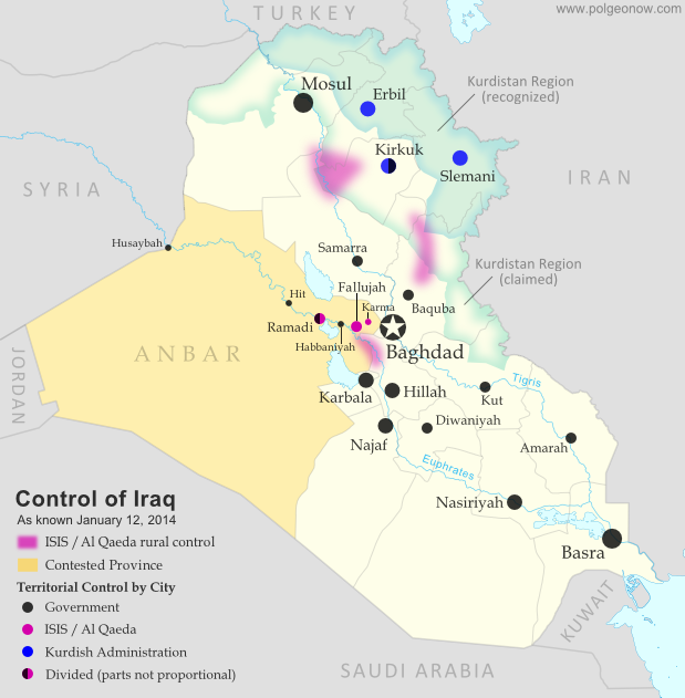
PolGeoNow presents our first map of Iraq, showing control by the government and Al Qaeda rebels in the country's ongoing crisis. Areas of autonomous Kurdish administration in the north are also indicated.

Want to see timely updates for this map? Subscribe to our premium member service!

Map of territorial control in Iraq in January 2014, including cities and countryside held by Al Qaeda (ISIS) as well as areas administered by Kurdistan
Territorial control in Iraq at the beginning of 2014. Map by Evan Centanni, starting from this blank map by German Wikipedia user NordNordWest. License: CC BY-SA
Premium members click here to view this article in the ad-free members area. Not a member yet? Subscribe now!

By Evan Centanni


Al Qaeda in Iraq
Though the reality is of course more complex, power politics in Iraq often revolve around the country's three largest ethnic groups: Shia (Shiite) Arabs, Sunni Arabs, and Kurds (most Kurds are religiously Sunni, but their language and cultural distinguish them from Arabs). Prime Minister Nouri al-Maliki, a Shia Arab, is often accused of manipulating Iraq's democracy to exclusively serve the country's Shia majority. The Kurds govern a highly autonomous region in the northeast, but the Sunni Arabs who dominate northwestern Iraq have relatively little political power. Into the fray has jumped Al Qaeda in Iraq, now part of the Islamic State of Iraq and al-Sham (ISIS) organization which also controls parts of Syria (map). Al Qaeda has waged a fierce campaign against the Iraqi government in the name of Sunnis, though the group is still rejected by many of the people it claims to protect.

Saturday, December 14, 2013

Syria Civil War Map: December 2013 (#12)

There are newer versions of this map available. To see them, view all Syria updates.

In addition to updates on the situation, our updated Syria control map now distinguishes the territory of extremist groups ISIS and Al-Nusra from that of Free Syrian Army or mixed rebel coalitions. (To see other maps in this series, view all Syria updates.)

Tired of waiting months for Syria map updates and briefings? Subscribers to our premium member service will soon begin seeing much more frequent Syria control updates. Don't miss out - sign up now!

Map of fighting and territorial control in Syria's Civil War (Free Syrian Army rebels, Kurdish groups, Al-Nusra Front, ISIS/ISIL and others), updated for December 2013. Includes recent locations of conflict and territorial control changes, Al-Safira, Khanaser, Maaloula, Qara, Nabek, and .
Area of fighting and territorial control in Syria's civil war, updated for December 2013. Map by Evan Centanni, starting from this blank map by German Wikipedia user NordNordWest. License: CC BY-SA
Premium members click here to view this article in the ad-free members area. Not a member yet? Subscribe now!

Al-Nusra and the ISIS
In addition to updates on the situation since our previous Syria war map, this edition of the map also shows which cities are controlled primarily by religious extremist groups the Al-Nusra Front and the Islamic State of Iraq and Syria (ISIS) (also translated from Arabic as ISIL, the Islamic State of Iraq and the Levant). While these groups share many of their goals with the Free Syrian Army and other rebel groups fighting the Assad government, and in many cases still cooperate strategically with those groups, they are increasingly emerging as a separate bloc in the multi-sided conflict.