 |
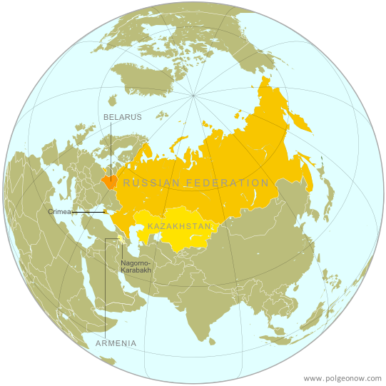
| The Eurasian Economic Union's four member countries, plus disputed territories that might be officially or unofficially included. Map by Evan Centanni, starting from this map by Keverich2. License: CC BY-SA |
Updates on the world's countries and borders
Showing posts with label europe. Show all posts
Showing posts with label europe. Show all posts
Tuesday, October 14, 2014
Map: "Eurasian Union" Gets New Member
Friday, September 19, 2014
Maps of How Scotland's Regions Really Voted
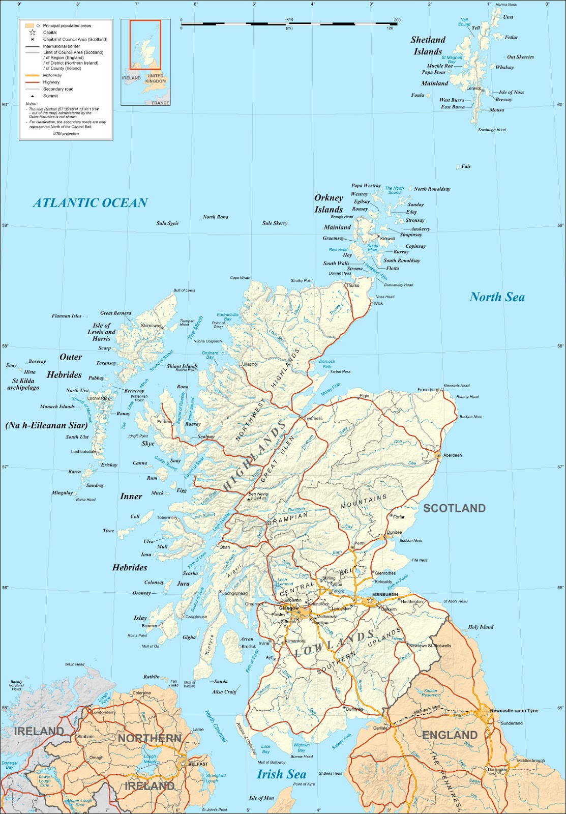
Good geographers know that maps can lie to you. Every map emphasizes some aspects of a place at the expense of others, giving it a lot of power to lead careless readers astray. Maps of Scotland's recent independence referendum are misleading us about the reality, even if not intentionally.
Premium members click here to view this article in the ad-free members area. Not a member yet? Subscribe now!
By Evan Centanni
Misleading Maps
By now you've probably heard the results of Scotland's independence referendum: voters chose "no" by a solid margin of 55% to 45%. Check out our previous article to learn more about what would have happened if Scotland had voted "yes".
Maps like this one from the BBC and this one from Wikipedia have popped up since the results came out, showing how each of Scotland's council areas voted. Most of the country is in red for "no", with a few "yes" areas in green.
But if one area went 51% for "yes", and another 51% for "no", those two areas actually voted almost identically - yet contrasting red/green maps make us feel like they're polar opposites (not to mention that one-in-thirty readers has trouble seeing the difference between red and green).
How the Councils Really Voted
Whether each area's people voted just over or just under 50% in favor isn't actually that important. What matters is how far the balance was tipped in each region. This is not the U.S. presidential election, where the final vote is actually made by delegates obligated to go by the majority in each state. All the votes across Scotland were pooled together to determine the result, so which side of the 50-yard line each area came out on has no effect .
Premium members click here to view this article in the ad-free members area. Not a member yet? Subscribe now!

|
| Map by Evan Centanni, based on blank map by TUBS and NordNordWest (CC BY-SA) |
Misleading Maps
By now you've probably heard the results of Scotland's independence referendum: voters chose "no" by a solid margin of 55% to 45%. Check out our previous article to learn more about what would have happened if Scotland had voted "yes".
Maps like this one from the BBC and this one from Wikipedia have popped up since the results came out, showing how each of Scotland's council areas voted. Most of the country is in red for "no", with a few "yes" areas in green.
But if one area went 51% for "yes", and another 51% for "no", those two areas actually voted almost identically - yet contrasting red/green maps make us feel like they're polar opposites (not to mention that one-in-thirty readers has trouble seeing the difference between red and green).
How the Councils Really Voted
Whether each area's people voted just over or just under 50% in favor isn't actually that important. What matters is how far the balance was tipped in each region. This is not the U.S. presidential election, where the final vote is actually made by delegates obligated to go by the majority in each state. All the votes across Scotland were pooled together to determine the result, so which side of the 50-yard line each area came out on has no effect .
Tuesday, September 16, 2014
Scottish Independence Poll: What is Scotland, and What Will Happen if it Votes to Leave the UK?
Premium members click here to view this article in the ad-free members area. Not a member yet? Subscribe now!
By Evan Centanni
It remained an independent kingdom throughout the Middle Ages, gradually absorbing Anglo-Saxon culture from the south until it came to be ruled by English-speaking monarchs, who called it "Scots" or "Scotland" after the Latin name for the Gaels, the predominant Celtic people of the region.
 |
| Map of Scotland by Eric Gaba (source). License: CC BY-SA |
Scotland's Independence Vote
On Thursday (September 18), residents of Scotland will vote in a referendum on whether to leave the United Kingdom (UK). But is Scotland a country already? What will happen if voters choose "yes" in the referendum? And what other changes would this bring to Scotland and the UK's political geography? Read on for the answers to these questions and more!Crash Course: History of Scotland
Scotland is the name of the northern third of Great Britain, the main island of the UK, which is shared with England to the south and Wales to the southwest. It originated as the Kingdom of Alba, an independent Celtic country that was unified around the year 900.It remained an independent kingdom throughout the Middle Ages, gradually absorbing Anglo-Saxon culture from the south until it came to be ruled by English-speaking monarchs, who called it "Scots" or "Scotland" after the Latin name for the Gaels, the predominant Celtic people of the region.
Tuesday, September 2, 2014
Ukraine War Rebel Control Map: September 2014 (Premium)
There are newer versions of this map available. To see them, view all Ukraine updates.

Russia is now being accused of directly invading eastern Ukraine, and opposition control in the region has seen major changes since our last Ukraine war map update.
This is detailed map and timeline of pro-Russian territorial control in eastern Ukraine's Donetsk and Luhansk regions, home to the claimed Donetsk People's Republic, Lugansk People's Republic, and Federation of Novorossiya. Updated to the start of September 2014.
This map report is exclusive premium content, available to paid subscribers or for individual purchase.
Buy now (US$9.99)
Premium map includes:
MEMBERS CLICK HERE TO PROCEED TO ARTICLE AND MAP
NOT A MEMBER YET? SUBSCRIBE NOW!

Download PDF buy |
This is detailed map and timeline of pro-Russian territorial control in eastern Ukraine's Donetsk and Luhansk regions, home to the claimed Donetsk People's Republic, Lugansk People's Republic, and Federation of Novorossiya. Updated to the start of September 2014.
This map report is exclusive premium content, available to paid subscribers or for individual purchase.
Buy now (US$9.99)
Premium map includes:
- Detailed, updated map of Donetsk and Luhansk regions, showing both past and current rebel control
- Indication of which districts and cities have had their administrations occupied by separatists
- Timeline of changes to territorial control since July, and summary of major trends
MEMBERS CLICK HERE TO PROCEED TO ARTICLE AND MAP
NOT A MEMBER YET? SUBSCRIBE NOW!
Thursday, August 28, 2014
Latvia Joins the Eurozone (map)
This article was originally published as "Map: Which Countries Use the Euro? (Plus: This Year's New Addition)". To see newer versions of the map, view all Eurozone articles on PolGeoNow.
Premium members click here to view this article in the ad-free members area. Not a member yet? Subscribe now!
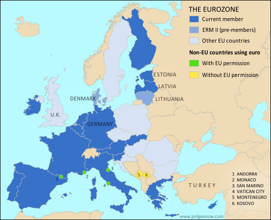 |
| The Eurozone, European Union, and other countries using the euro. Map by Evan Centanni, from blank map by Ssolbergj. License: CC BY-SA |
Thursday, August 21, 2014
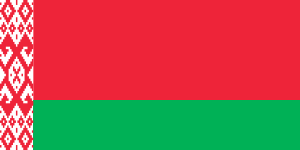
Belarus's Quiet Flag Change
Sometimes geopolitical changes make headlines, but other times they slip quietly under the radar. Such is the case with the flag of Belarus, which was changed without fanfare (or explanation) by a government decree back in 2012. We don't want you to miss any changes to the world's list of countries and flags, so we now present a belated report on this little-known event.
Premium members click here to view this article in the ad-free members area. Not a member yet? Subscribe now!
By Caleb Centanni
Belarus, a former Soviet state in Eastern Europe, made a slight change to its flag in early 2012. On Feb. 10 of that year, the State Committee for the Standardization of the Republic of Belarus announced a minor change to the ornamental pattern on the left margin of the flag.
The pattern originally occupied one-twelfth of the flag's total length, and was located inside a white margin making up one-ninth of the flag design. The ornamental pattern has now been extended to fill the entire one-ninth margin. The Belarusian government apparently provided no specific reason for the change.
Other than this minor adjustment, the current flag of Belarus has been in place since 1995, when it replaced the traditional white-red-white flag after a controversial referendum that critics denounced as unconstitutional.
Belarusian President Alexander Lukashenko supported the adoption of the 1995 flag, which is very similar to the Soviet-era flag. State-owned media argued the traditional tricolor flag was unacceptable due to its use by Nazi collaborators in World War II.
Premium members click here to view this article in the ad-free members area. Not a member yet? Subscribe now!
|
.png)
.png)
Belarus, a former Soviet state in Eastern Europe, made a slight change to its flag in early 2012. On Feb. 10 of that year, the State Committee for the Standardization of the Republic of Belarus announced a minor change to the ornamental pattern on the left margin of the flag.
The pattern originally occupied one-twelfth of the flag's total length, and was located inside a white margin making up one-ninth of the flag design. The ornamental pattern has now been extended to fill the entire one-ninth margin. The Belarusian government apparently provided no specific reason for the change.
Other than this minor adjustment, the current flag of Belarus has been in place since 1995, when it replaced the traditional white-red-white flag after a controversial referendum that critics denounced as unconstitutional.
Belarusian President Alexander Lukashenko supported the adoption of the 1995 flag, which is very similar to the Soviet-era flag. State-owned media argued the traditional tricolor flag was unacceptable due to its use by Nazi collaborators in World War II.
Thursday, July 24, 2014
Map Update: Kosovo Recognized by 3 More Countries in 2014 (106/193)
Premium members click here to view this article in the ad-free members area. Not a member yet? Subscribe now!
 |
| Countries recognizing the Republic of Kosovo in green, highlighting recent additions. Disputed recognitions in yellow. Kosovo in magenta. Map by Evan Centanni, modified from public domain graphic (source). |
Tuesday, July 22, 2014
War in Ukraine: Detailed Map of Rebel Control in Donetsk & Luhansk (Premium)

Download PDF buy |
Since our last Ukraine update, pro-Russian rebels have captured much more territory in Donetsk and Luhansk regions, but also lost some of their early strongholds.
This map report is exclusive premium content, available to paid subscribers or for individual purchase.
Buy now (US$9.99)
Premium map includes:
- All new, detailed map of Donetsk and Luhansk regions, showing both past and current rebel control
- Indication of which districts and cities have had their administrations occupied by separatists
- Important locations of rebel military control marked
- Article with chronology of events since April, and discussion of the meaning of "control"
MEMBERS CLICK HERE TO PROCEED TO ARTICLE AND MAP
NOT A MEMBER YET? SUBSCRIBE NOW!
Saturday, May 3, 2014
Mayotte Enters European Union
 |
"Outermost regions" are officially part of the European Union; "overseas countries and territories" are not part of the EU itself, but have special relations with it because of their connections to member countries. New outermost region Mayotte is located in southeastern Africa. Map from Wikimedia Commons © Alexrk2 (CC BY-SA)
|
Article by Evan Centanni
EU Expands to Include Mayotte
You probably heard about Croatia joining the European Union last year, but did you know the EU expanded further this year...in Africa? The French overseas department of Mayotte, a group of islands in the Indian Ocean northwest of Madagascar, became officially part of the EU on January 1.
Wednesday, April 16, 2014
Ukraine Map #3: Separatist Control in the East (Premium)

Download PDF buy |
This is an up-to-date and detailed map of pro-Russian rebel and protester control in Ukraine, including the self-proclaimed "Donetsk People's Republic".
This map and article are exclusive premium content, available only to members or for individual purchase. Buy now (US$5.99).
Premium article includes:
- Ukraine control map updated for the protester occupations and armed rebel takeovers in eastern Ukraine over the past two weeks
- Shows both protester occupations and armed takeovers, as well as which regions have declared independence
- Includes a quick briefing on recent events, with links to the sources of information
Not a member yet? Subscribe Now!
Saturday, April 5, 2014
Update: Ukraine Control Overview Map (Premium)

Download PDF buy |
The current article is an update on the current control situation in Ukraine from Mar. 4 to the present. This map and article are exclusive premium content, available only to members or for individual purchase. Buy now (US$5.99).
Premium article includes:
- Simple updated map of the political situation in Ukraine since Mar. 4
- Shows the last of the pro-Russian protester occupations, the annexation of Crimea, and seizures by the Ukrainian and Russian militaries outside of Crimea proper
- Report on the course of events since the last report, explaining each detail shown on the map
- In-line links to sources of information
Members click here to proceed to article and map
Not a member yet? Subscribe Now!
Thursday, March 27, 2014
Crimea Joins Russia, Gives Up Independence, Becomes Disputed Territory
Premium members click here to view this article in the ad-free members area. Not a member yet? Subscribe now!
By Evan Centanni
Russia Annexes Crimea
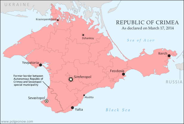
The Crimean peninsula, which declared independence from Ukraine ten days ago as the Republic of Crimea, has now been absorbed into Russia. This was part of the plan all along - the claimed Republic of Crimea had requested to join Russia at the same time that it declared independence.
Related: Complete Map of Locations Seized by Russia in Crimea (Premium)
 |
The claimed Republic of Crimea which has now joined Russia (click to see full-sized map). By Evan Centanni, based on this blank map.
|
Russia Annexes Crimea
The Crimean peninsula, which declared independence from Ukraine ten days ago as the Republic of Crimea, has now been absorbed into Russia. This was part of the plan all along - the claimed Republic of Crimea had requested to join Russia at the same time that it declared independence.
Related: Complete Map of Locations Seized by Russia in Crimea (Premium)
Wednesday, March 26, 2014
Premium Map Report: Russian Control of Crimea

Download PDF buy |
Premium article includes:
- Exclusive map of Russian seizure and attack locations inside and outside of Crimea
- Guide to all locations on the map, with brief summary of what has happened at each
- In-line links to sources of information
Members click here to proceed to article and map
Not a member yet? Subscribe Now!
Tuesday, March 18, 2014
Crimea Declares Independence: Is It Really a Country?
On Monday, two regional governments on the Crimean Peninsula controversially declared their independence from Ukraine as the new Republic of Crimea. While the declaration has been rejected by most of the world community, and Crimea hopes to swiftly unite with Russia, for now it might be considered a de facto sovereign state. Read on for details.
Premium members click here to view this article in the ad-free members area. Not a member yet? Subscribe now!
By Evan Centanni
Declaration of Independence
Following Ukraine's revolution, the explosion of pro-Russian protests in the east, and the subsequent occupation of the Crimean peninsula by Russian forces (see our premium report, Ukraine Map: Occupations, Autonomy, & Invasion), a new independent country has been declared on the coast of the Black Sea.
 |
| The Republic of Crimea. Map by Evan Centanni, based on this blank map. |
Declaration of Independence
Following Ukraine's revolution, the explosion of pro-Russian protests in the east, and the subsequent occupation of the Crimean peninsula by Russian forces (see our premium report, Ukraine Map: Occupations, Autonomy, & Invasion), a new independent country has been declared on the coast of the Black Sea.
Saturday, March 8, 2014
How Sharply Divided is Ukraine, Really? Honest Maps of Language and Elections
There's no question that Ukraine's current crisis arose from major political divisions in the country, and it's true that language is an issue. But some online news websites have sensationalized and exaggerated these divisions through misleading maps. PolGeoNow offers a pair of maps that better communicate the blurriness of the supposed lines between western and eastern Ukraine.
(For a map of current events from January up to this week, including protester control, government occupations, and the Russian invasion, purchase our premium map of the Ukraine crisis or become a member.)
Premium members click here to view this article in the ad-free members area. Not a member yet? Subscribe now!
Article by Evan Centanni
Misleading Ukraine Maps
In January, the Washington Post's Max Fisher wrote a popular map-illustrated blog post about the political and linguistic divisions fueling Ukraine's crisis, then at the height of its pro-Europe protest phase. Later, CNN followed the Post's lead and published a similar set of maps. However, the maps in both articles are designed in a way that makes the divisions look much sharper and more black-and-white than they really are. There's not, as Fisher preposterously claims, "an actual, physical line" splitting Ukraine in half. Instead, there's a gradual shading of mixed populations whose ethnic identities and voting history don't always correlate to the country's current political divisions.
(For a map of current events from January up to this week, including protester control, government occupations, and the Russian invasion, purchase our premium map of the Ukraine crisis or become a member.)
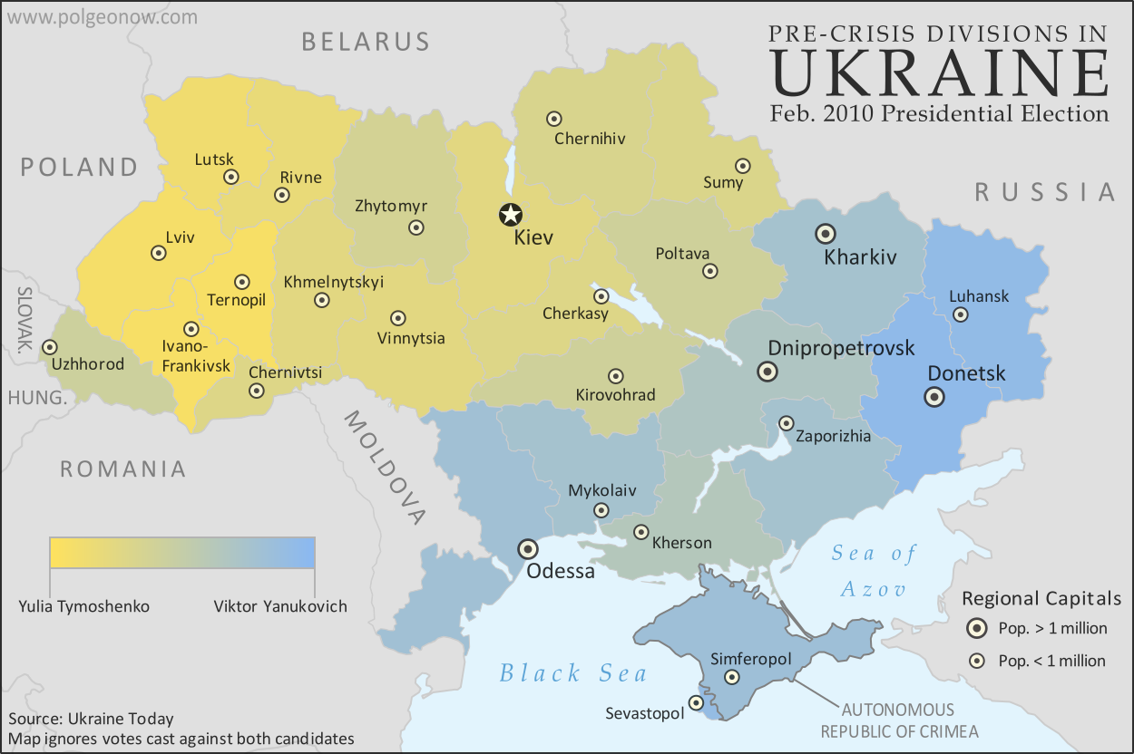 |
A more honest map of Ukraine's 2010 presidential election. By Evan Centanni.
|
Article by Evan Centanni
Misleading Ukraine Maps
In January, the Washington Post's Max Fisher wrote a popular map-illustrated blog post about the political and linguistic divisions fueling Ukraine's crisis, then at the height of its pro-Europe protest phase. Later, CNN followed the Post's lead and published a similar set of maps. However, the maps in both articles are designed in a way that makes the divisions look much sharper and more black-and-white than they really are. There's not, as Fisher preposterously claims, "an actual, physical line" splitting Ukraine in half. Instead, there's a gradual shading of mixed populations whose ethnic identities and voting history don't always correlate to the country's current political divisions.
Monday, March 3, 2014
Ukraine Map: Occupations, Autonomy, & Invasion (Premium)

Download PDF buy |
Premium article includes:
- Exclusive map of the political situation in Ukraine's 2014 crisis
- Shows protester occupations, regional capitals overrun, autonomy declarations, and locations of Russian military siege
- Report on the course of events, explaining each detail shown on the map
- In-line links to sources of information
Members click here to proceed to article and map
Not a member yet? Subscribe Now!
Thursday, October 17, 2013
Map Update: Kosovo Recognized by 3 More Countries (103/193)
 |
| Countries recognizing the Republic of Kosovo in green, highlighting recent additions. Disputed recognitions in yellow. Kosovo in magenta. Map by Evan Centanni, modified from public domain graphic (source). |
Thursday, August 15, 2013
Map: Kosovo Recognized by 4 More Countries (101/193)
 |
| Countries recognizing the Republic of Kosovo in green, with the four most recent additions highlighted. Disputed recognitions in yellow. Kosovo in magenta. Map by Evan Centanni, modified from public domain graphic (source). |
Tuesday, July 2, 2013
Croatia Joins EU, leaves CEFTA
 |
| The European Union. Map by Evan Centanni, from this blank map by Ssolbergj. License: CC BY-SA |
Saturday, April 20, 2013
North Kosovo Status Changing After Serbia Deal
 |
| Map by Evan Centanni, based on these two blank maps by Nord-NordWest. License: CC BY-SA |
Serbia and the breakaway Republic of Kosovo reached a landmark deal on Friday to normalize their relations, partially compromising on several contentious issues between the two governments in southeastern Europe. Kosovo declared its independence from Serbia in 2008, but due to Serbia's opposition it has still not achieved full international recognition.
Status Change for North Kosovo
North Kosovo is the largest of several areas within Kosovo where the majority of people are part of the Serb ethnic group, whereas 90% of people in Kosovo as a whole are ethnically Albanian. When Kosovo split from Serbia, many Serbs in the north refused to go, governing themselves separately from Kosovo and choosing instead to continue cooperating with and accepting government funding from Serbia.
Subscribe to:
Posts (Atom)