Showing posts with label europe. Show all posts

Saturday, April 5, 2014

Update: Ukraine Control Overview Map (Premium)

Updated map of control in Ukraine, as of April 5, 2014. Includes final protester occupations, annexation of Crimea, and areas seized by Russian and Ukrainian militaries outside of Crimea.

Download PDF
buy


(Subscribe via Paypal)
This is a brief supplement to our Mar. 4 report, Ukraine Map: Occupations, Autonomy, & Invasion. See that report for a detailed overview of protester occupations and declarations of autonomy in the first two stages of the Ukraine crisis: the anti-Yanukovich Maidan movement and the eastern pro-Russian protests. 

The current article is an update on the current control situation in Ukraine from Mar. 4 to the present. This map and article are exclusive premium content, available only to members or for individual purchase. Buy now (US$5.99).

Premium article includes:
  • Simple updated map of the political situation in Ukraine since Mar. 4
  • Shows the last of the pro-Russian protester occupations, the annexation of Crimea, and seizures by the Ukrainian and Russian militaries outside of Crimea proper
  • Report on the course of events since the last report, explaining each detail shown on the map
  • In-line links to sources of information

Members click here to proceed to article and map

Not a member yet? Subscribe Now!


Thursday, March 27, 2014

Crimea Joins Russia, Gives Up Independence, Becomes Disputed Territory

Premium members click here to view this article in the ad-free members area. Not a member yet? Subscribe now!

Map of the claimed Republic of Crimea, which briefly declared independence from Ukraine on Mar. 17 before being annexed by Russia
The claimed Republic of Crimea which has now joined Russia (click to see full-sized map). By Evan Centanni, based on this blank map.
By Evan Centanni

Russia Annexes Crimea
The Crimean peninsula, which declared independence from Ukraine ten days ago as the Republic of Crimea, has now been absorbed into Russia. This was part of the plan all along - the claimed Republic of Crimea had requested to join Russia at the same time that it declared independence.

Related: Complete Map of Locations Seized by Russia in Crimea (Premium)

Wednesday, March 26, 2014

Premium Map Report: Russian Control of Crimea

Map of Russian seizures and military actions in the Crimea region which it recently annexed from Ukraine.

Download PDF
buy


(Subscribe via Paypal)
After a month of low-level conflict, Russian military control of Crimea appears to be nearly complete. Here's a complete map - to the best of our knowledge - of all locations of Russian seizures and other military actions inside and outside of the Crimea region. This map and article are exclusive premium content, available only to members and for individual purchase. Buy now (US$4.99).

Premium article includes:
  • Exclusive map of Russian seizure and attack locations inside and outside of Crimea
  • Guide to all locations on the map, with brief summary of what has happened at each
  • In-line links to sources of information

Members click here to proceed to article and map

Not a member yet? Subscribe Now!


Tuesday, March 18, 2014

Crimea Declares Independence: Is It Really a Country?

On Monday, two regional governments on the Crimean Peninsula controversially declared their independence from Ukraine as the new Republic of Crimea. While the declaration has been rejected by most of the world community, and Crimea hopes to swiftly unite with Russia, for now it might be considered a de facto sovereign state. Read on for details.

Map of the newly declared independent Republic of Crimea, seceding from Ukraine to join Russia (colorblind accessible).
The Republic of Crimea. Map by Evan Centanni, based on this blank map.
Premium members click here to view this article in the ad-free members area. Not a member yet? Subscribe now!

By Evan Centanni

Declaration of Independence
Following Ukraine's revolution, the explosion of pro-Russian protests in the east, and the subsequent occupation of the Crimean peninsula by Russian forces (see our premium report, Ukraine Map: Occupations, Autonomy, & Invasion), a new independent country has been declared on the coast of the Black Sea.

Saturday, March 8, 2014

How Sharply Divided is Ukraine, Really? Honest Maps of Language and Elections

There's no question that Ukraine's current crisis arose from major political divisions in the country, and it's true that language is an issue. But some online news websites have sensationalized and exaggerated these divisions through misleading maps. PolGeoNow offers a pair of maps that better communicate the blurriness of the supposed lines between western and eastern Ukraine. 

(For a map of current events from January up to this week, including protester control, government occupations, and the Russian invasion, purchase our premium map of the Ukraine crisis or become a member.)

Map of the results of Ukraine's February 2010 presidential runoff election between Yulia Tymoshenko and Viktor Yanukovich
A more honest map of Ukraine's 2010 presidential election. By Evan Centanni.
Premium members click here to view this article in the ad-free members area. Not a member yet? Subscribe now!

Article by Evan Centanni 

Misleading Ukraine Maps
In January, the Washington Post's Max Fisher wrote a popular map-illustrated blog post about the political and linguistic divisions fueling Ukraine's crisis, then at the height of its pro-Europe protest phase. Later, CNN followed the Post's lead and published a similar set of maps. However, the maps in both articles are designed in a way that makes the divisions look much sharper and more black-and-white than they really are. There's not, as Fisher preposterously claims, "an actual, physical line" splitting Ukraine in half. Instead, there's a gradual shading of mixed populations whose ethnic identities and voting history don't always correlate to the country's current political divisions.

Monday, March 3, 2014

Ukraine Map: Occupations, Autonomy, & Invasion (Premium)

Map of the 2014 Ukraine crisis, before and after the ouster of President Yanukovich, updated to March 3, 2014. Details shown include protester occupations, declarations of autonomy, and Russian invasion.

Download PDF
buy


(Subscribe via Paypal)
PolGeoNow begins our Ukraine coverage with this overview of the political situation from January to the present, both before and after the overthrow of President Viktor Yanukovich's government. Details shown include protester occupations, declarations of autonomy, and Russian invasion. This map and article are exclusive premium content, available only to members and for individual purchase. Buy now (US$5.99).

Premium article includes:
  • Exclusive map of the political situation in Ukraine's 2014 crisis
  • Shows protester occupations, regional capitals overrun, autonomy declarations, and locations of Russian military siege
  • Report on the course of events, explaining each detail shown on the map
  • In-line links to sources of information

Members click here to proceed to article and map

Not a member yet? Subscribe Now!


Thursday, October 17, 2013

Map Update: Kosovo Recognized by 3 More Countries (103/193)

Map of countries that recognize the Republic of Kosovo as an independent state, updated for October 2013 with most recent additions (Thailand, Libya, Granada) and disputed recognitions highlighted
Countries recognizing the Republic of Kosovo in green, highlighting recent additions. Disputed recognitions in yellow. Kosovo in magenta. Map by Evan Centanni, modified from public domain graphic (source).

Thursday, August 15, 2013

Map: Kosovo Recognized by 4 More Countries (101/193)

Map of countries that recognize the Republic of Kosovo as an independent state, updated for August 2013 with most recent additions and disputed recognitions highlighted
Countries recognizing the Republic of Kosovo in green, with the four most recent additions highlighted. Disputed recognitions in yellow. Kosovo in magenta. Map by Evan Centanni, modified from public domain graphic (source).

Saturday, April 20, 2013

North Kosovo Status Changing After Serbia Deal

Map of Serbia, Kosovo, and North Kosovo
Map by Evan Centanni, based on these two blank maps by Nord-NordWest. License: CC BY-SA
Kosovo & Serbia in Historic Agreement
Serbia and the breakaway Republic of Kosovo reached a landmark deal on Friday to normalize their relations, partially compromising on several contentious issues between the two governments in southeastern Europe. Kosovo declared its independence from Serbia in 2008, but due to Serbia's opposition it has still not achieved full international recognition. 

Status Change for North Kosovo
North Kosovo is the largest of several areas within Kosovo where the majority of people are part of the Serb ethnic group, whereas 90% of people in Kosovo as a whole are ethnically Albanian. When Kosovo split from Serbia, many Serbs in the north refused to go, governing themselves separately from Kosovo and choosing instead to continue cooperating with and accepting government funding from Serbia.

Friday, April 5, 2013

Kosovo Recognition Update: April 2013 (99/193)

Map of countries that recognize the Republic of Kosovo as an independent state, updated for April 2013 with most recent additions highlighted
Countries recognizing the Republic of Kosovo in green, with the two most recent additions highlighted. Disputed recognitions in yellow. Kosovo in magenta. Map by Evan Centanni, modified from public domain graphic (source).

Friday, March 15, 2013

What is Vatican City?

This week, the Catholic Church chose a new leader, Pope Francis. The selection and announcement of the new pope took place in Vatican City, the Church's sovereign territory within Rome. Is Vatican City really "the world's smallest country", or a country at all?  And what's the difference between Vatican City and the Holy See? Read all about it!


Large scale (close-up) map of Vatican City
Map of Vatican City (click to enlarge). By Francesco Piraneo G./Wikimedia Commons (CC BY-SAsource).
What is Vatican City?

Vatican City was created by the Lateran Treaty in 1929 to ensure the Catholic Church's independence from the control of other countries, and has an area of only about 0.17 sq mi (0.44 sq km), or about one-eighth the size of Central Park in New York. In addition to the Pope, the state said to have a population of about 800, most of whom are either clergy or members of the Swiss Guard.

Located within the city of Rome, Vatican City is surrounded on all sides by Italy, and nearly encircled by a stone city wall except for in St. Peter's Square, where it is separated from Italy only by a white line drawn on the ground. Various religious and administrative buildings are located within Vatican City's confines, but more than half of its area is taken up by the green space of the Vatican Gardens.

Friday, February 22, 2013

Catalonia: Europe’s Newest Nation?

Even relatively stable Europe hosts its share of geopolitical tensions: Catalonia, a major region of Spain which has long claimed a unique national identity, may now be on the path towards independence. Read on for a profile of what could become one of the world's newest countries.

Map of Catalonia's location within Spain and relative to neighboring countries
Map by Evan Centanni, based on this map by Mutxamel. License: CC BY-SA
By Omar Alkhalili

What is Catalonia?

Catalonia is an autonomous community of Spain. It holds the official status of a nationality within the Spanish parliamentary monarchy. Regions of Spain with this status are considered to be something similar to countries within the larger Spanish nation, allowing for their own separateness from Spanish mainstream culture without actually being considered independent.

Thursday, December 20, 2012

Kosovo Now Recogized by Half of U.N. (97/193)

Map of countries that recognize the Republic of Kosovo as an independent state, updated for December 2012 with most recent additions highlighted
Countries recognizing the Republic of Kosovo in green, with the five most recent additions to the list labelled. Kosovo in magenta. Map by Evan Centanni, modified from public domain graphic (source).

Thursday, October 18, 2012

Kosovo Recognized by Papua New Guinea (92/193)

Map of countries that recognize the Republic of Kosovo as independent, updated for Papua New Guinea's recognition in October 2012
Countries recognizing the Republic of Kosovo in green, with the most recent, Papua New Guinea (lower right), in lighter green. Kosovo in magenta. Map by Evan Centanni, modified from public domain graphic (source).

Thursday, June 21, 2012

Kosovo Recognized by Chad (Total: 91/193)

Map of countries that recognize the Republic of Kosovo as independent, updated for June 2012
Countries recognizing the Republic of Kosovo in green, with the most recent, Chad, in lighter green (click to enlarge). Kosovo in magenta. Map by Evan Centanni, modified from public domain wiki map (source).

Wednesday, May 2, 2012

Kosovo Recognition Update (Total: 90/193)

Country Name: Kosovo (English, Serbian), Kosova (Albanian)
Official Name: Republic of Kosovo (English), Republika e Kosovës (Albanian),
Republika Kosovo (Serbian)
News Categories: Recognition, Partially Recognized States, Breakaway States
Full Story: See Kosovo Diplomatic Recognition Continues

Map of countries that recognize the Republic of Kosovo as independent
Countries recognizing the Republic of Kosovo in green, with arrows marking the two most recent: São Tomé and Príncipe (left) and Brunei (right). Kosovo in magenta. Modified from public domain wiki map (source).

Thursday, March 15, 2012

Kosovo Diplomatic Recognition Continues

Country Name: Kosovo (English, Serbian), Kosova (Albanian)
Official Name: Republic of Kosovo (English), Republika e Kosovës (Albanian),
Republika Kosovo (Serbian)
News Categories: Recognition, Partially Recognized States, Breakaway States
Summary: The Republic of Kosovo has continued to receive diplomatic recognition from other countries, despite widespread opposition to its 2008 declaration of independence from Serbia. Thirteen more U.N. members have declared their recognition of independent Kosovo just within the last year.

Flag of the Republic of Kosovo
Flag of the Republic of Kosovo.
Image by Cradel (source). License: CC BY-SA
Full Story
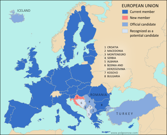
The majority of recently independent countries, such as South Sudan and Montenegro, enjoy unopposed recognition from the U.N. and its members. However, acceptance into the international community doesn't always come so easily. Kosovo is one example: because it declared its independence without first coming to an agreement with its former host country (unlike South Sudan and Montenegro), it has struggled to gain acceptance as a sovereign state. The last of the Balkan countries to declare independence after the breakup of Yugoslavia in the 1990s, Kosovo was first separated unofficially from the country in 1999, when NATO intervened militarily in the province to stop Serbian government violence against ethnic Albanians. The Albanians are a cultural group from southeastern Europe who speak a unique language only distantly related to other European tongues, and like the Bosniaks in nearby Bosnia & Herzegovia, are one of the few majority-Muslim European peoples. They also form a majority of the population in the neighboring country of Albania.

Map of Kosovo within Serbia
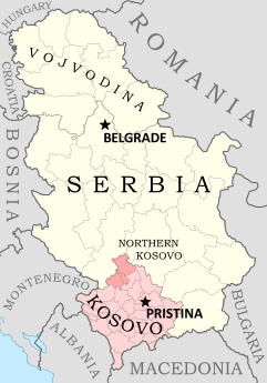
Kosovo, claimed as a province of Serbia, is
policed by U.N. and E.U. peacekeepers. The
Republic of Kosovo also governs the region,
except for the Serbian-loyalist north. Map is
my own work, based on these two blank
maps by Nord-NordWest. License: CC BY-SA
Policed by a U.N. peacekeeping mission since 1999, most of Kosovo has never since been controlled by the Yugoslav (now Serbian) government, though the U.N. still officially considers it to be a province of Serbia. Despite fierce political opposition from Serbia, Russia, and other countries, as well as from the ethnic Serb minority within Kosovo, the local government declared independence in 2008. The self-proclaimed Republic of Kosovo government has since administered the territory alongside the U.N. and another police force sent by the European Union, though the Northern Kosovo area, a Serb-majority region, has resisted independence and continues to support the Serbian government in Belgrade, even setting up roadblocks to keep out the Kosovan police - a sort of breakaway state within a breakaway state.

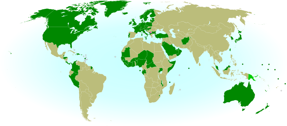
The Republic of Kosovo has not been admitted into the U.N., and it is recognized by only 88 U.N. member countries (many of them NATO members or countries with Muslim populations) and one other state (Taiwan). Serbia and Russia still strongly oppose independence for Kosovo, but the list of states recognizing its sovereignty has nevertheless continued to grow. Within the last year, 13 more U.N. members have offered diplomatic recognition of Kosovan independence: Andorra, the Central African Republic, Guinea, Niger, Benin, Saint Lucia, Nigeria, Gabon, Ivory Coast, Kuwait, Uganda, Ghana, and Haiti.

Map of countries recognizing the Republic of Kosovo
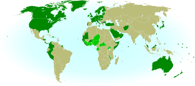
Diplomatic recognition of the Republic of Kosovo. Countries that recognized Kosovan independence recently (in the last twelve months) in light green, others in dark green; Kosovo in magenta. Public domain (source).
Sources: See citations on Wikipedia's list of Entities that recognize Kosovo as an independent state.

Sunday, January 22, 2012

Hungary Shortens Official Name

Country Name: Hungary (English), Magyarország (Hungarian)
News Category: Name Changes
Summary: Hungary's full official name changed from "Republic of Hungary" to just "Hungary" when a new constitution came into effect in the Central European country at the beginning of this year.

Full Story
Map of Hungary from the CIA World Factbook (public domain)
A member of the Soviet-influenced Eastern Bloc during the Cold War, Hungary was one of the many European countries that underwent major reforms after the fall of the Iron Curtain in 1989. Its name was changed from "People's Republic of Hungary" to "Republic of Hungary", and the old communist constitution was heavily amended to welcome in democracy.


Wednesday, December 21, 2011

WTO Admits New Members

Organization: World Trade Organization
Countries in Question: Vanuatu, Russia, Montenegro, Samoa
News Categories: Intergovernmental Organizations
Summary: The World Trade Organization, the intergovernmental organization supervising international trade between the majority of the world's countries, admitted one new member last October, and three more last week. Especially notable was the admission last Friday of Russia, which was by far the largest economy not to have joined previously.

Full Story
While some intergovernmental organizations, such as the U.N. or regional unions, were created for general purposes of cooperation between states, others serve more specific purposes. The World Trade Organization (WTO) is one of these, acting as a venue for countries to agree on rules for international trade. Among its members, economic agreements are subject to rules aimed at liberalizing international trade, and trade-related disputes are also arbitrated through the organization. Formed in 1995 as a replacement for weaker trade treaties of the past, by 2008 the WTO represented approximately 80% of the world's independent countries.

World Trade Organization members in green. Countries joining this year in brighter green, with small countries circled. Modified from this Wikimedia map (license: CC BY-SA).


This October, the WTO grew for the first time in three years, with the acceptance of the Pacific island country of Vanuatu's as a member. Just last week, three more countries joined: Russia, Montenegro, and Samoa. Samoa is another small Pacific island country, and Montenegro was only formed a few years ago from the final breakup of former Yugoslavia. Russia, however, has gained much attention for being the last of the world's major economic powers to join the organization. Although it first applied for admission to the group 18 years ago, before the modern WTO was even formed, until recently Russia was slow to proceed with membership negotiations. For the last few years, it was blocked from entry by Georgia, a WTO member protesting its invasion by Russia during the 2008 war between the two countries, but that hurdle was finally crossed after a Swiss-brokered agreement between Russia and Georgia earlier this year. Although the four new countries have been accepted by the organization, their governments will still have to ratify the agreements in order for them to become full participating members.