Showing posts with label asia. Show all posts

Monday, December 16, 2019

Yemen Control Map & Report - December 2019 (Subscription)

SUBSCRIBERS CLICK HERE TO PROCEED TO ARTICLE AND MAP

There are newer versions of this map available. To see them, view all Yemen articles on PolGeoNow.

Timeline by Djordje Djukic. Map by Evan Centanni, Djordje Djukic, and onestopmap.com

Map of what is happening in Yemen as of December 15, 2019, including territorial control for the unrecognized Houthi government, president-in-exile Hadi and his allies in the Saudi-led coalition, the UAE-backed southern separatist Southern Transitional Council (STC), and Al Qaeda in the Arabian Peninsula (AQAP). Includes recent locations of fighting and other events, including Ahwar, Baqim, Malahith, and more.
Subscribe for full access to all conflict map reports!

Over the past two months, separatists seeking an independent South Yemen have held onto control of port city Aden and other towns, despite attempts at reconciliation with the Saudi-backed government of President Hadi. Meanwhile, the rival Houthi government still controls much of the country.

See all this and more on the newest update to PolGeoNow's Yemen territorial control map, which includes a timeline of changes and important events since our previous Yemen map report in October.

This map and report are premium content available to paid subscribers of the PolGeoNow Conflict Mapping Service.

Want to see before you buy? Check out our most recent FREE SAMPLE Yemen map report!

Exclusive report includes:
  • Up-to-date map of current territorial control in Yemen, color-coded for the pro-Hadi coalition, the separatist Southern Transitional Council (STC), Houthi forces, and Al Qaeda in the Arabian Peninsula (AQAP).
  • Detailed indication of town-by-town control, including provincial boundaries, all major cities, and many smaller ones
  • Markers for recent areas of fighting, including Ahwar, Baqim, Malahith, and more
  • Timeline of changes to the situation since October 12, 2019, with links to sources 

SUBSCRIBERS CLICK HERE TO PROCEED TO ARTICLE AND MAP

Not a member yet? Click here to learn more about our professional subscription service!

Can I purchase just this map?
This map and report are not available for automated purchase to non-subscribers. If you need access or republication rights for only this map report, contact service@polgeonow.com for options.

Saturday, November 30, 2019

Syrian Civil War Map & Timeline - November 2019 (Subscription)

SUBSCRIBERS CLICK HERE TO PROCEED TO ARTICLE AND MAP

There are newer versions of this map available. To see them, view all Syria updates.

Research by Djordje Djukic. Map by onestopmap.com, Evan Centanni, and Djordje Djukic

Subscribe for full access to all conflict map reports!

Map of Syrian Civil War (Syria control map): Territorial control in Syria in November 2019 (Free Syrian Army rebels, Kurdish YPG, Syrian Democratic Forces (SDF), Hayat Tahrir al-Sham (HTS / Al-Nusra Front), Islamic State (ISIS/ISIL), and others). Includes Turkish/TFSA control, joint SDF-Assad control, US deconfliction zone, and Turkey-Russia demilitarized buffer zone, plus recent locations of conflict and territorial control changes, including Ras al-Ayn, Tel Abyad, Ayn Issa, and more. Colorblind accessible. In the past month, Turkey and its allies have further consolidated their chunk of territory in northern Syria, while the Assad-loyal Syrian military has deployed along most of the rest of the border, in line with the Russia-brokered agreement for a "safe zone" free of Kurdish militia fighters.

See all this and more on the latest update to PolGeoNow's concise, professional Syrian Civil War control map, which includes a timeline of changes since our previous Syria map report in October, with sources cited.

This map and report are premium content, available to paid subscribers of the PolGeoNow Conflict Mapping Service.

Want to see before you subscribe? Check out our most recent FREE SAMPLE Syria map!

Exclusive map report includes:
  • NEW: Special symbols for joint Turkish/rebel control and joint SDF/government control, so you can track Turkey's intervention in the border region
  • Up-to-date illustration of current territorial control in Syria, color-coded for the Assad government, rebel groups, "Islamic State" (ISIS/ISIL) fighters, and the Kurdish-led Syrian Democratic Forces (SDF). Colorblind accessible.
  • Extent of "buffer zone" sponsored by Turkey and Russia in the rebel-held northwest
  • Outline showing approximate location of the one publicly-known US "deconfliction zone"
  • Special symbols indicating towns dominated by rebels of the former Al Qaeda Nusra Front (now Hayat Tahrir al-Sham or HTS) and by the Kurdish YPG militia (part of the SDF anti-IS coalition).
  • Detailed indication of city-by-city control, including key towns and other locations important to current events.
  • Locations of recent control changes and other important events, including Ras al-Ayn, Tel Abyad, Ayn Issa, and more.
  • Detailed timeline of important events and changes to territorial control since October 27, 2019, compiled by our Syria-Iraq expert, with links to sources. 

SUBSCRIBERS CLICK HERE TO PROCEED TO ARTICLE AND MAP

Not signed up yet? Click here to learn more about our professional subscription service!

Can I purchase just this map?
This map and report are not available for automated purchase to non-subscribers. If you need access or republication rights for only this map report, contact service@polgeonow.com for options.

Sunday, October 27, 2019

Syrian Civil War Map & Timeline: Turkey Enters Northeast - October 2019 (Subscription)

SUBSCRIBERS CLICK HERE TO PROCEED TO ARTICLE AND MAP

There are newer versions of this map available. To see them, view all Syria updates.

Research by Djordje Djukic. Map by onestopmap.com, Evan Centanni, and Djordje Djukic

Subscribe for full access to all conflict map reports!

Map of Syrian Civil War (Syria control map): Territorial control in Syria in October 2019 (Free Syrian Army rebels, Kurdish YPG, Syrian Democratic Forces (SDF), Hayat Tahrir al-Sham (HTS / Al-Nusra Front), Islamic State (ISIS/ISIL), and others). Includes Turkish control, joint SDF-Assad control, US deconfliction zone, and Turkey-Russia demilitarized buffer zone, plus recent locations of conflict and territorial control changes, including Ras al-Ayn, Tel Abyad, Ayn Issa, and more. Colorblind accessible. Amid a US withdrawal, Turkey and its rebel allies have begun their long-threatened intervention against Kurdish-led fighters in northeastern Syria, who now have struck a deal with the Assad government to share their territory and jointly fight back against Turkey.

See all this and more on the latest update to PolGeoNow's concise, professional Syrian Civil War control map, which includes a timeline of changes since our previous Syria map report in September, with sources cited.

This map and report are premium content, available to paid subscribers of the PolGeoNow Conflict Mapping Service.

Want to see before you subscribe? Check out our most recent FREE SAMPLE Syria map!

Exclusive map report includes:
  • NEW: Special symbols for joint Turkish/rebel control and joint SDF/government control, so you can track Turkey's intervention in the border region
  • EXTRA: Label for Barisha village, where IS leader Abu Bakr al-Baghdadi died in a US raid this weekend
  • Up-to-date illustration of current territorial control in Syria, color-coded for the Assad government, rebel groups, "Islamic State" (ISIS/ISIL) fighters, and the Kurdish-led Syrian Democratic Forces (SDF). Colorblind accessible.
  • Extent of "buffer zone" sponsored by Turkey and Russia in the rebel-held northwest
  • Outline showing approximate location of the one publicly-known US "deconfliction zone"
  • Special symbols indicating towns dominated by rebels of the former Al Qaeda Nusra Front (now Hayat Tahrir al-Sham or HTS) and by the Kurdish YPG militia (part of the SDF anti-IS coalition).
  • Detailed indication of city-by-city control, including key towns and other locations important to current events.
  • Locations of recent control changes and other important events, including Ras al-Ayn, Tel Abyad, Ayn Issa, and more.
  • Detailed timeline of important events and changes to territorial control since September 10, 2019, compiled by our Syria-Iraq expert, with links to sources. 

SUBSCRIBERS CLICK HERE TO PROCEED TO ARTICLE AND MAP

Not signed up yet? Click here to learn more about our professional subscription service!

Can I purchase just this map?
This map and report are not available for automated purchase to non-subscribers. If you need access or republication rights for only this map report, contact service@polgeonow.com for options.

Saturday, October 12, 2019

Yemen Control Map & Report - October 2019

There are newer versions of this map available. To see them, view all Yemen articles on PolGeoNow.

Map of what is happening in Yemen as of October 12, 2019, including territorial control for the unrecognized Houthi government, president-in-exile Hadi and his allies in the Saudi-led coalition, the UAE-backed southern separatist Southern Transitional Council (STC), and Al Qaeda in the Arabian Peninsula (AQAP). Includes recent locations of fighting and other events, including Ataq, Mahfad, Al Wadhea, Ketaf, and more.
Map by Evan Centanni and Djordje Djukic, from base map by Koen Adams of onestopmap.com.
Contact us for permission to use this map.
(Subscribers click here to view this article in the member area)

Timeline by Djordje Djukic

Yemen More Divided Than Ever

In the month and a half since our previous Yemen control map report, the separatists of the Southern Transitional Council (STC) have held onto control over much of the country's south, pushing the internationally-recognized Hadi government to abandon Aden and set up a new "interim capital" in the eastern town of Ataq. Meanwhile, fighting between Hadi-loyal forces and the north's rival Houthi government has continued, with both sides capturing territory from each other near the Saudi border.

Monday, September 23, 2019

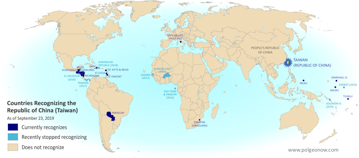
Taiwan Loses "Recognition" from Two Pacific Allies (Map)

You can always find the latest version of this map, and a list of all related articles, on our Which Countries "Recognize" Taiwan? page.

Map of who recognizes Taiwan (what countries recognize the Republic of China) in September 2019. Marks countries that have cut diplomatic ties with Taiwan (withdrawn recognition) in the last ten years: Kiribati, Solomon Islands, El Salvador, Burkina Faso, the Dominican Republic, Panama, Sao Tome and Principe, and the Gambia. Also answers question: Where is Republic of China located? (Colorblind accessible)
Click to enlarge. By Evan Centanni, modified from public domain blank world map.
Contact us for permission to use this map.

Map: Which Countries "Recognize" Taiwan in 2019?

This map and explainer will be updated whenever there's a change to the list of Taiwan's "diplomatic allies". You can find articles on each change by scrolling to the bottom of this page, or by viewing all Taiwan articles on PolGeoNow.

Map of who recognizes Taiwan (what countries recognize the Republic of China) in September 2019. Marks countries that have cut diplomatic ties with Taiwan (withdrawn recognition) in the last ten years: Kiribati, Solomon Islands, El Salvador, Burkina Faso, the Dominican Republic, Panama, Sao Tome and Principe, and the Gambia. Also answers question: Where is Republic of China located? (Colorblind accessible)
Click to enlarge. By Evan Centanni, modified from public domain blank world map.
Contact us for permission to use this map.

Is Taiwan a Country?

At PolGeoNow we frequently report on self-proclaimed, unrecognized or partially-recognized countries - but Taiwan is a special case. It operates like an independent country today, but has never formally declared independence. Instead, Taiwan and its surrounding islands govern themselves as the "Republic of China" (ROC), under a constitution brought there by a former government of the Chinese mainland.

Thursday, September 12, 2019

Syrian Civil War Map & Timeline - September 2019

There are newer versions of this map available. To see them, view all Syria updates.

Map of Syrian Civil War (Syria control map): Territorial control in Syria in September 2019 (Free Syrian Army rebels, Kurdish YPG, Syrian Democratic Forces (SDF), Hayat Tahrir al-Sham (HTS / Al-Nusra Front), Islamic State (ISIS/ISIL), and others). Includes US deconfliction zone and Turkey-Russia demilitarized buffer zone, plus recent locations of conflict and territorial control changes, including Khan Shaykhun, Kabani, Morek, and more. Colorblind accessible.
Base map by Koen Adams of onestopmap.com, with territorial control by Evan Centanni and Djordje Djukic.
Contact us for permission to use this map.
(Subscribers click here to view this article in the member area)

Timeline by Djordje Djukic

Government Captures Rebel Stronghold in Idlib

In what's been nearly a month since our previous Syria control map update, almost all major activities have been focused around the southern end of rebel-held Idlib province. For the first time, government forces have captured a major town on the rebel side of the of would-be buffer zone set up last year by Turkey and Russia. Meanwhile, possible changes loom in Syria's northeast, where Turkey is pushing the US to set up a "safe zone" to keep the Kurdish-majority YPG militia away from the border.

Thursday, September 5, 2019

Map: Indonesia Makes Plans to Move Capital

Map: Indonesia says it's moving its capital from Jakarta to a new location in Borneo. Map shows old site, approximate new site, former capital on Yogyakarta, and Palangkaraya, which was considered for the location of the new capital but not chosen.

(Based on blank map by Wikipedia user Indon. License: CC BY-SA)

A PolGeoNow News Brief

Here at Political Geography Now, we prioritize reporting on things in the world that have actually changed. But sometimes news about future or possible changes, like Belize and Guatemala going to court over their border dispute, are interesting enough that we want to share them with you sooner. This article represents a new format where we'll be publishing short, to-the-point summaries of those kinds of geography news stories. As always, we encourage you to tell us what you think by leaving a comment on our Twitter or Facebook!

Saturday, August 31, 2019

Yemen Control Map & Report: Separatists Seize South - August 2019 (Subscription)

SUBSCRIBERS CLICK HERE TO PROCEED TO ARTICLE AND MAP

There are newer versions of this map available. To see them, view all Yemen articles on PolGeoNow.

Map of what is happening in Yemen as of August 31, 2019, including territorial control for the unrecognized Houthi government, president-in-exile Hadi and his allies in the Saudi-led coalition, the UAE-backed southern separatist Southern Transitional Council (STC), and Al Qaeda in the Arabian Peninsula (AQAP). Includes recent locations of fighting, including Ataq, Zinjibar, Shuqra, Ketaf, and more. Colorblind accessible.
Subscribe for full access to all conflict map reports!

Timeline by Djordje Djukic. Map by Evan Centanni, Djordje Djukic, and onestopmap.com

In recent weeks, a major new front has broken out in Yemen's civil war, as southern separatists have broken ranks with the Saudi-backed government of President Hadi, seizing control of key areas in the country's south.

See all this and more on the newest update to PolGeoNow's Yemen territorial control map, which includes a timeline of changes and important events since our previous Yemen map report in June. This report also includes a BONUS MAP showing the height of southern separatist control earlier in August.

This map and report are premium content available to paid subscribers of the PolGeoNow Conflict Mapping Service.

Want to see before you buy? Check out our most recent FREE SAMPLE Yemen map report!

Exclusive report includes:
  • Up-to-date map of current territorial control in Yemen, color-coded for the pro-Hadi coalition, the separatist Southern Transitional Council (STC), Houthi forces, and Al Qaeda in the Arabian Peninsula (AQAP).
  • Detailed indication of town-by-town control, including provincial boundaries, all major cities, and many smaller ones
  • Markers for recent areas of fighting, including Shuqra, Ataq, Balhaf, Ketaf, and more
  • Timeline of changes to the situation since June 15, 2019, with links to sources 
  • BONUS MAP showing the height of southern separatist control earlier in August

SUBSCRIBERS CLICK HERE TO PROCEED TO ARTICLE AND MAP

Not a member yet? Click here to learn more about our professional subscription service!

Can I purchase just this map?
This map and report are not available for automated purchase to non-subscribers. If you need access or republication rights for only this map report, contact service@polgeonow.com for options.
Saturday, August 17, 2019

Syrian Civil War Map & Timeline - August 2019 (Subscription)

SUBSCRIBERS CLICK HERE TO PROCEED TO ARTICLE AND MAP

There are newer versions of this map available. To see them, view all Syria updates.

Research by Djordje Djukic. Map by onestopmap.com, Evan Centanni, and Djordje Djukic

Subscribe for full access to all conflict map reports!

Map of Syrian Civil War (Syria control map): Territorial control in Syria in August 2019 (Free Syrian Army rebels, Kurdish YPG, Syrian Democratic Forces (SDF), Hayat Tahrir al-Sham (HTS / Al-Nusra Front), Islamic State (ISIS/ISIL), and others). Includes US deconfliction zone and Turkey-Russia demilitarized buffer zone, plus recent locations of conflict and territorial control changes, including Khan Shaykhun, Kabani, and more. Colorblind accessible. Over the past month and a half, fighting between rebels and government forces in the northwest has dominated events in Syria. Meanwhile, the so-called "Islamic State" (ISIS/ISIL) remains confined to uninhabited desert areas of central Syria.

See all this and more on the latest update to PolGeoNow's concise, professional Syrian Civil War control map, which includes a timeline of changes since our previous Syria map report in July, with sources cited.

This map and report are premium content, available to paid subscribers of the PolGeoNow Conflict Mapping Service.

Want to see before you subscribe? Check out our most recent FREE SAMPLE Syria map!

Exclusive map report includes:
  • Up-to-date illustration of current territorial control in Syria, color-coded for the Assad government, rebel groups, "Islamic State" (ISIS/ISIL) fighters, and the Kurdish-led Syrian Democratic Forces (SDF). Colorblind accessible.
  • Location of the demilitarized buffer zone sponsored by Turkey and Russia
  • Outline showing the approximate location of the one publicly-known US "deconfliction zone"
  • Special symbols indicating towns dominated by rebels of the former Al Qaeda Nusra Front (now Hayat Tahrir al-Sham or HTS) and by the Kurdish YPG militia (part of the US-backed SDF).
  • Detailed indication of city-by-city control, including key towns and other locations important to current events.
  • Locations of recent control changes and other important events, including Khan Shaykhun, Kabani, and more.
  • Detailed timeline of important events and changes to territorial control since July 1, 2019, compiled by our Syria-Iraq expert, with links to sources. 

SUBSCRIBERS CLICK HERE TO PROCEED TO ARTICLE AND MAP

Not signed up yet? Click here to learn more about our professional subscription service!

Can I purchase just this map?
This map and report are not available for automated purchase to non-subscribers. If you need access or republication rights for only this map report, contact service@polgeonow.com for options.

Wednesday, July 3, 2019

Syrian Civil War Map & Timeline - July 2019 (Subscription)

SUBSCRIBERS CLICK HERE TO PROCEED TO ARTICLE AND MAP

There are newer versions of this map available. To see them, view all Syria updates.

Research by Djordje Djukic. Map by onestopmap.com, Evan Centanni, and Djordje Djukic

Subscribe for full access to all conflict map reports!

Map of Syrian Civil War (Syria control map): Territorial control in Syria in July 2019 (Free Syrian Army rebels, Kurdish YPG, Syrian Democratic Forces (SDF), Hayat Tahrir al-Sham (HTS / Al-Nusra Front), Islamic State (ISIS/ISIL), and others). Includes US deconfliction zone and Turkey-Russia demilitarized buffer zone, plus recent locations of conflict and territorial control changes, such Kafr Nabudah, Kabani, Al-Kawm, and more. Colorblind accessible. The past month and a half have seen continued fighting and many small changes to territorial control around the edges of the rebel-held area in Syria's northwest. The so-called "Islamic State" (ISIS/ISIL) remains active in the desert of central Syria, and is thought to control a large area of uninhabited land, but no longer seems to govern any towns.

See all this and more on the latest update to PolGeoNow's concise, professional Syrian Civil War control map, which includes a timeline of changes since our previous Syria map report in May, with sources cited.

This map and report are premium content, available to paid subscribers of the PolGeoNow Conflict Mapping Service.

Want to see before you subscribe? Check out our most recent FREE SAMPLE Syria map!

Exclusive map report includes:
  • Up-to-date illustration of current territorial control in Syria, color-coded for the Assad government, rebel groups, "Islamic State" (ISIS/ISIL) fighters, and the Kurdish-led Syrian Democratic Forces (SDF). Colorblind accessible.
  • Location of the demilitarized buffer zone sponsored by Turkey and Russia
  • Outline showing the approximate location of the one publicly-known US "deconfliction zone"
  • Special symbols indicating towns dominated by rebels of the former Al Qaeda Nusra Front (now Hayat Tahrir al-Sham or HTS) and by the Kurdish YPG militia (part of the US-backed SDF).
  • Detailed indication of city-by-city control, including key towns and other locations important to current events.
  • Locations of recent control changes and other important events, including Kafr Nabudah, Kabani, Al-Kawm, and more.
  • Detailed timeline of important events and changes to territorial control since May 14, 2019, compiled by our Syria-Iraq expert, with links to sources. 

SUBSCRIBERS CLICK HERE TO PROCEED TO ARTICLE AND MAP

Not signed up yet? Click here to learn more about our professional subscription service!

Can I purchase just this map?
This map and report are not available for automated purchase to non-subscribers. If you need access or republication rights for only this map report, contact service@polgeonow.com for options.

Sunday, June 16, 2019

Yemen Control Map & Report - June 2019 (Subscription)

SUBSCRIBERS CLICK HERE TO PROCEED TO ARTICLE AND MAP

There are newer versions of this map available. To see them, view all Yemen articles on PolGeoNow.

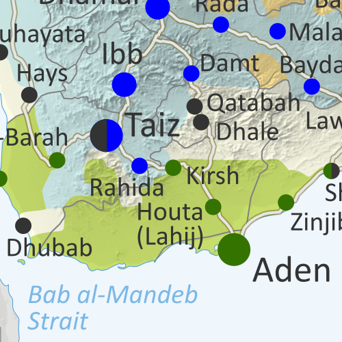
Map of what is happening in Yemen as of June 15, 2019, including territorial control for the unrecognized Houthi government and former president Saleh's forces, president-in-exile Hadi and his allies in the Saudi-led coalition and Southern Movement, and Al Qaeda in the Arabian Peninsula (AQAP). Includes recent locations of fighting, including Qatabah, Dhale, Ketaf, Harad, and more. Colorblind accessible.
Subscribe for full access to all conflict map reports!

Timeline by Djordje Djukic. Map by Evan Centanni, Djordje Djukic, and onestopmap.com

In the past six months, fighting over Yemen's Hodeida port has died down under a UN-supervised ceasefire, but battles and changes of territory between the Houthi and Hadi governments have continued on other fronts.

See all this and more on the newest update to PolGeoNow's Yemen territorial control map, which includes a timeline of changes and important events since our previous Yemen map report in December.

This map and report are premium content available to paid subscribers of the PolGeoNow Conflict Mapping Service.

Want to see before you buy? Check out our most recent FREE SAMPLE Yemen map report!

Exclusive report includes:
  • Up-to-date map of current territorial control in Yemen, color-coded for the pro-Hadi coalition, Houthi forces, and Al Qaeda in the Arabian Peninsula (AQAP).
  • Detailed indication of town-by-town control, including provincial boundaries, all major cities, and many smaller ones
  • Markers for recent areas of fighting, including Qatabah, Dhale, Ketaf, Harad, and more
  • Timeline of changes to the situation since December 6, 2018, with links to sources

SUBSCRIBERS CLICK HERE TO PROCEED TO ARTICLE AND MAP

Not a member yet? Click here to learn more about our professional subscription service!

Can I purchase just this map?
This map and report are not available for automated purchase to non-subscribers. If you need access or republication rights for only this map report, contact service@polgeonow.com for options.
Wednesday, May 15, 2019

Syrian Civil War Map & Timeline: Fight Resumes for Northwest - May 2019 (Subscription)

SUBSCRIBERS CLICK HERE TO PROCEED TO ARTICLE AND MAP

There are newer versions of this map available. To see them, view all Syria updates.

Research by Djordje Djukic. Map by onestopmap.com, Evan Centanni, and Djordje Djukic

Subscribe for full access to all conflict map reports!

Map of Syrian Civil War (Syria control map): Territorial control in Syria in May 2019 (Free Syrian Army rebels, Kurdish YPG, Syrian Democratic Forces (SDF), Hayat Tahrir al-Sham (HTS / Al-Nusra Front), Islamic State (ISIS/ISIL), and others). Includes US deconfliction zone and Turkey-Russia demilitarized buffer zone, plus recent locations of conflict and territorial control changes, such as Al Kawm, Qalaat al-Madiq, Kafr Nabudah, and more. Colorblind accessible. A new phase of fighting has begun in Syria's northwest, as the Assad government makes a new push across the Turkish-Russian "buffer zone" into rebel-held territory. Meanwhile, the so-called "Islamic State" (ISIS/ISIL) has captured a new town in the central desert.

See all this and more on the latest update to PolGeoNow's concise, professional Syrian Civil War control map, which includes a timeline of changes since our previous Syria map report in March, with sources cited.

This map and report are premium content, available to paid subscribers of the PolGeoNow Conflict Mapping Service.

Want to see before you subscribe? Check out our most recent FREE SAMPLE Syria map!

Exclusive map report includes:
  • Up-to-date illustration of current territorial control in Syria, color-coded for the Assad government, rebel groups, "Islamic State" (ISIS/ISIL) fighters, and the Kurdish-led Syrian Democratic Forces (SDF). Colorblind accessible.
  • Location of the demilitarized buffer zone sponsored by Turkey and Russia
  • Outline showing the approximate location of the one publicly-known US "deconfliction zone"
  • Special symbols indicating towns dominated by rebels of the former Al Qaeda Nusra Front (now Hayat Tahrir al-Sham or HTS) and by the Kurdish YPG militia (part of the US-backed SDF).
  • Detailed indication of city-by-city control, including key towns and other locations important to current events.
  • Locations of recent control changes and other important events, including Al Kawm, Qalaat al-Madiq, Kafr Nabudah, and more.
  • Detailed timeline of important events and changes to territorial control since March 28, 2019, compiled by our Syria-Iraq expert, with links to sources. 

SUBSCRIBERS CLICK HERE TO PROCEED TO ARTICLE AND MAP

Not signed up yet? Click here to learn more about our professional subscription service!

Can I purchase just this map?
This map and report are not available for automated purchase to non-subscribers. If you need access or republication rights for only this map report, contact service@polgeonow.com for options.

Saturday, March 30, 2019

Syrian Civil War Map & Timeline: IS Loses Last Town - March 2019 (Subscription)

SUBSCRIBERS CLICK HERE TO PROCEED TO ARTICLE AND MAP

There are newer versions of this map available. To see them, view all Syria updates.

Research by Djordje Djukic. Map by onestopmap.com, Evan Centanni, and Djordje Djukic

Subscribe for full access to all conflict map reports!

Map of Syrian Civil War (Syria control map): Territorial control in Syria in March 2019, when IS control has been reduced to only some areas of desert after the group lost its last town (Free Syrian Army rebels, Kurdish YPG, Syrian Democratic Forces (SDF), Hayat Tahrir al-Sham (HTS / Al-Nusra Front), Islamic State (ISIS/ISIL), and others). Includes US deconfliction zone and Turkey-Russia demilitarized buffer zone, plus recent locations of conflict and territorial control changes, such as Baghuz, Murashidah, the Doubayat gas field, and more. Colorblind accessible. The so-called "Islamic State" (ISIS/ISIL) has lost its last populated territory in Syria, but it still operates freely in some remote desert areas. Meanwhile, the situation remains tense along the Russia-Turkey-brokered "buffer zone" between rebel and government territory in the northwest.

See all this and more on the latest update to PolGeoNow's concise, professional Syrian Civil War control map, which includes a timeline of changes since our previous Syria map report in January, with sources cited.

This map and report are premium content, available to paid subscribers of the PolGeoNow Conflict Mapping Service.

Want to see before you subscribe? Check out our most recent FREE SAMPLE Syria map!

Exclusive map report includes:
  • Up-to-date illustration of current territorial control in Syria, color-coded for the Assad government, rebel groups, "Islamic State" (ISIS/ISIL) fighters, and the Kurdish-led Syrian Democratic Forces (SDF). Colorblind accessible.
  • Location of the demilitarized buffer zone sponsored by Turkey and Russia
  • Outline showing the approximate location of the one publicly-known US "deconfliction zone"
  • Special symbols indicating towns dominated by rebels of the former Al Qaeda Nusra Front (now Hayat Tahrir al-Sham or HTS) and by the Kurdish YPG militia (part of the US-backed SDF).
  • Detailed indication of city-by-city control, including key towns and other locations important to current events.
  • Locations of recent control changes and other important events, including Baghuz, Murashidah, Saraqeb, Arima and more.
  • Detailed timeline of important events and changes to territorial control since January 27, 2019, compiled by our Syria-Iraq expert, with links to sources. 

SUBSCRIBERS CLICK HERE TO PROCEED TO ARTICLE AND MAP

Not signed up yet? Click here to learn more about our professional subscription service!

Can I purchase just this map?
This map and report are not available for automated purchase to non-subscribers. If you need access or republication rights for only this map report, contact service@polgeonow.com for options.

Thursday, March 7, 2019

2015 in Afghanistan: Map of Taliban and "Islamic State" Control

Hidden image for crawlers (To see other maps in this series, view all Afghanistan updates.)

Welcome to PolGeoNow's new series of Afghanistan control maps! In the coming months, we'll publish more maps and timelines spanning the gap between 2015 and 2019, leading into routine updates of the current situation. To secure your access to all future installments, sign up now for our professional conflict map subscription service!


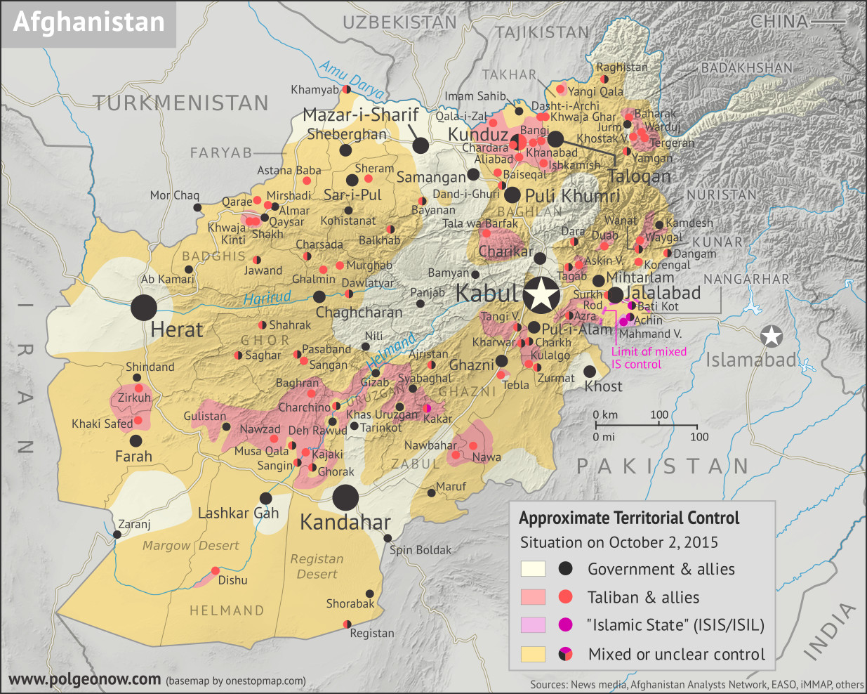
Where in Afghanistan is the war? Map of Taliban control in Afghanistan in October 2015, during the Taliban's takeover of Kunduz city and at the height of so-called Islamic State (ISIS/ISIL) control in Nangharhar province. Also marks areas of government control and unclear or mixed control. Includes all of Afghanistan's major cities, plus selected towns, including many sites of Taliban control. Colorblind accessible.
Basemap by Koen Adams of onestopmap.com, with territorial control by Evan Centanni.
Contact us for permission to use this map.


(Subscribers click here to view this article on the member site)

Timeline by Evan Centanni

Afghanistan: Who Controlled What in 2015?

The date is October 2, 2015. In the year and a half since the low point of Taliban control shown in our April 2014 Afghanistan map, the rebel group has been steadily expanding its territory. Most recently, the Taliban have launched a surprise takeover of Kunduz city, one of northern Afghanistan's major population centers, and the first provincial capital they've controlled since their national government was overthrown in 2001. Meanwhile, as the current government pours all its resources into taking the city back, the Taliban take advantage of the chaos to seize control of various other districts across the Afghan countryside.

Meanwhile, the so-called "Islamic State" (IS; formerly ISIS/ISIL), based thousands of kilometers to the west in Iraq and Syria, has established a formidable new branch in Afghanistan. This IS affiliate - known officially as "Khorasan Province" - has carved out a small territory of its own in Nangarhar, along the border with Pakistan, and is now reaching what will be the height of its power in Afghanistan. Though both IS and the Taliban are religious hardliners, IS's brutal tactics, largely foreign membership, and claimed superiority have made it an enemy of the Taliban, and left it with very little support among the Afghan people.

Monday, January 28, 2019

Syrian Civil War Map & Timeline: January 2019 (Subscription)

SUBSCRIBERS CLICK HERE TO PROCEED TO ARTICLE AND MAP

There are newer versions of this map available. To see them, view all Syria updates.

Research by Djordje Djukic. Map by onestopmap.com, Evan Centanni, and Djordje Djukic

Subscribe for full access to all conflict map reports!

Map of Syrian Civil War (Syria control map): Territorial control in Syria in January 2019, when IS control has been reduced to only one village and some areas of desert (Free Syrian Army rebels, Kurdish YPG, Syrian Democratic Forces (SDF), Hayat Tahrir al-Sham (HTS / Al-Nusra Front), Islamic State (ISIS/ISIL), and others). Includes US deconfliction zone and Turkey-Russia demilitarized buffer zone, plus recent locations of conflict and territorial control changes, such as Baghuz, Murashidah, Saraqeb, Arima, and more. Colorblind accessible. Over the past month, the so-called "Islamic State" (ISIS/ISIL) in Syria has been reduced to just a single village and some remote desert areas, while the country's north braces for a new phase of the war after US withdrawal.

See all this and more on the latest update to PolGeoNow's concise, professional Syrian Civil War control map, which includes a timeline of changes since our previous Syria map report in December, with sources cited.

This map and report are premium content, available to paid subscribers of the PolGeoNow Conflict Mapping Service.

Want to see before you subscribe? Check out our most recent FREE SAMPLE Syria map!

Exclusive map report includes:
  • Up-to-date illustration of current territorial control in Syria, color-coded for the Assad government, rebel groups, "Islamic State" (ISIS/ISIL) fighters, and the Kurdish-led Syrian Democratic Forces (SDF). Colorblind accessible.
  • Location of the demilitarized buffer zone sponsored by Turkey and Russia
  • Outline showing the approximate location of the one publicly-known US "deconfliction zone"
  • Special symbols indicating towns dominated by rebels of the former Al Qaeda Nusra Front (now Hayat Tahrir al-Sham or HTS) and by the Kurdish YPG militia (part of the US-backed SDF).
  • Detailed indication of city-by-city control, including key towns and other locations important to current events.
  • Locations of recent control changes and other important events, including Baghuz, Murashidah, Saraqeb, Arima and more.
  • Detailed timeline of important events and changes to territorial control since December 26, 2018, compiled by our Syria-Iraq expert, with links to sources. 

SUBSCRIBERS CLICK HERE TO PROCEED TO ARTICLE AND MAP

Not signed up yet? Click here to learn more about our professional subscription service!

Can I purchase just this map?
This map and report are not available for automated purchase to non-subscribers. If you need access or republication rights for only this map report, contact service@polgeonow.com for options.

Sunday, December 30, 2018

All About South Ossetia's 2017 Name Change

South Ossetia (purple) and Abkhazia (green) within the claimed borders of Georgia. Click to enlarge. Map by ChrisO based on UN map of Georgia (public domain; source).

Adding "State of Alania"

At PolGeoNow we promise to inform our readers any time one of the world's countries changes its name, even if it's just a modification to the country's official long name, or a switch in the name's preferred English translation.

But there was one name change we missed out on reporting last year - depending on what you consider a "country".

In April 2017, people in the disputed Republic of South Ossetia voted to change the self-declared country's full name to "The Republic of South Ossetia – the State of Alania". The name change referendum reportedly passed with about 80% of valid votes in favor, though many countries strongly condemned the whole process, seeing it as part of an ongoing Russia-led attempt to steal the region away from Georgia (the country, not the US state).

Map: Which Countries Recognized Abkhazia and South Ossetia in 2018?

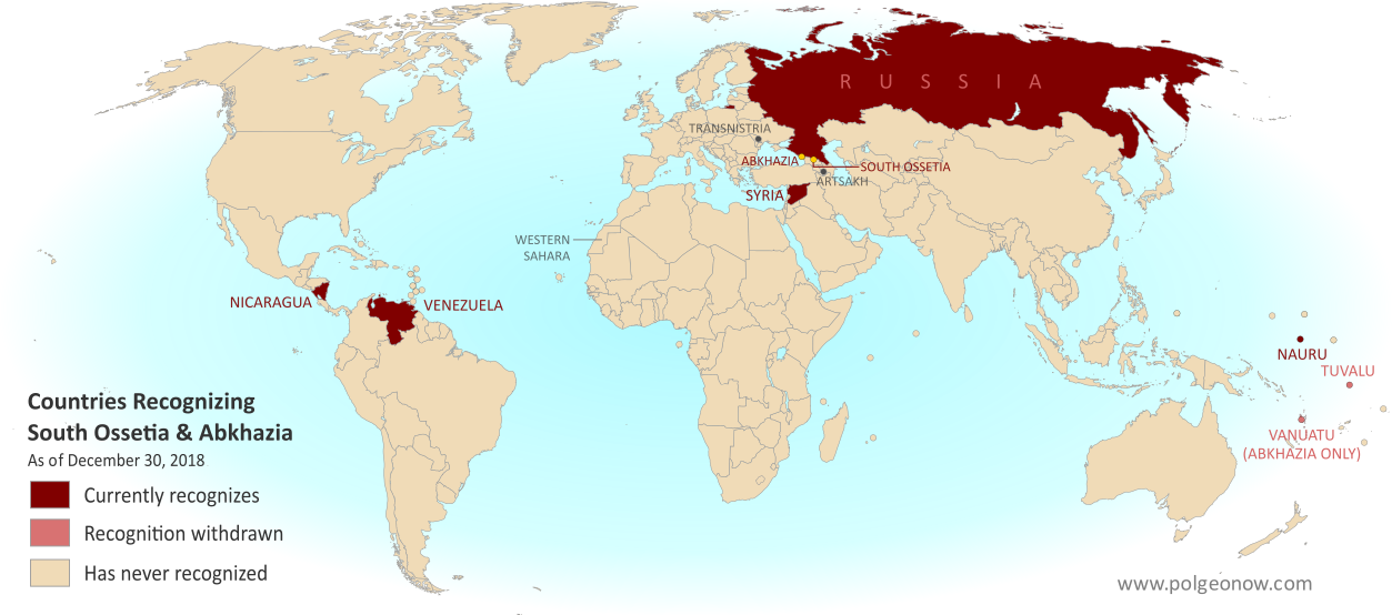
This is our new, completely redesigned map of which countries consider disputed South Ossetia and Abkhazia to be independent from Georgia. From now on, PolGeoNow will report on any changes to Abkhazian or South Ossetian recognition with updates to this map.

Map of what countries recognize South Ossetia and Abkhazia as independent from Georgia in December 2018. Includes Russia, Nicaragua, Venezuela, Nauru, new recognizer Syria, disputed or withdrawn recognitions from Tuvalu and Vanuatu, and unrecognized countries Transistria, Artsakh (Nagorno-Karabakh), and Western Sahara whose self-proclaimed governments also recognize the so-called Georgian breakaways.(Colorblind accessible)
Click to enlarge. By Evan Centanni, modified from public domain blank world map.
Contact us for permission to use this map.

Friday, December 28, 2018

Syrian Civil War Map & Timeline: IS Loses Western Enclave - December 2018

There are newer versions of this map available. To see them, view all Syria updates.

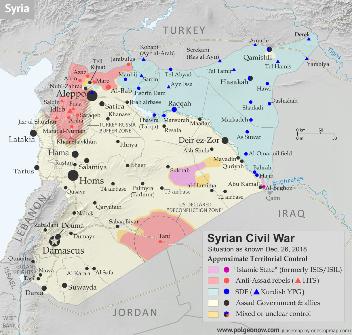
Map of Syrian Civil War (Syria control map): Territorial control in Syria in December 2018, just before the US troop withdrawal (Free Syrian Army rebels, Kurdish YPG, Syrian Democratic Forces (SDF), Hayat Tahrir al-Sham (HTS / Al-Nusra Front), Islamic State (ISIS/ISIL), and others). Includes US deconfliction zone and Turkey-Russia demilitarized buffer zone, plus recent locations of conflict and territorial control changes, such as Hajin, Al Safa, Baghuz, and more. Colorblind accessible.
Base map by Koen Adams of onestopmap.com, with territorial control by Evan Centanni and Djordje Djukic.
Contact us for permission to use this map.
(Subscribers click here to view this article on the member site)

Timeline by Djordje Djukic

Syria: Where Things Stand Now

In the month and a half since our previous Syria control map report, the main territorial changes have been losses by the so-called "Islamic State" (IS; formerly ISIS/ISIL). The Assad government has eliminated the last pocket of IS control in western Syria, in the south's Al Safa area, and the Kurdish-led Syrian Democratic Forces (SDF) have recaptured the town of Hajin in the east, while also driving IS once again off of the Syria-Iraq border.

Saturday, December 8, 2018

Yemen Control Map & Report: Battle of Hodeida Begins - December 2018 (Subscription)

SUBSCRIBERS CLICK HERE TO PROCEED TO ARTICLE AND MAP

There are newer versions of this map available. To see them, view all Yemen articles on PolGeoNow.

Map of what is happening in Yemen as of December 6, 2018, including territorial control for the unrecognized Houthi government and former president Saleh's forces, president-in-exile Hadi and his allies in the Saudi-led coalition and Southern Movement, Al Qaeda in the Arabian Peninsula (AQAP), and the so-called Islamic State (ISIS/ISIL). Includes recent locations of fighting, including Hodeida, Malahith, Baqim, and more. Colorblind accessible.
Subscribe for full access to all conflict map reports!

Timeline by Djordje Djukic. Map by Evan Centanni, Djordje Djukic, and onestopmap.com


After the pro-Hadi coalition's months of stop-and-go movement towards the Houthi-held port city of Hodeida, the battle has finally moved into the city itself. Meanwhile, fighting has also continued along the Saudi border.

See all this and more on the newest update to PolGeoNow's Yemen territorial control map, which includes a timeline of changes and important events since our previous Yemen map report in September.

This map and report are premium content available to paid subscribers of the PolGeoNow Conflict Mapping Service.

Want to see before you buy? Check out our most recent FREE SAMPLE Yemen map report!

Exclusive report includes:
  • Up-to-date map of current territorial control in Yemen, color-coded for the pro-Hadi coalition, Houthi forces, Al Qaeda in the Arabian Peninsula (AQAP), and the so-called "Islamic State" (ISIS/ISIL)
  • Detailed indication of town-by-town control, including provincial boundaries, all major cities, and many smaller ones
  • Markers for recent areas of fighting, including Hodeida, Malahith, Baqim, and more
  • Timeline of changes to the situation since September 12, 2018, with links to sources

SUBSCRIBERS CLICK HERE TO PROCEED TO ARTICLE AND MAP

Not a member yet? Click here to learn more about our professional subscription service!

Can I purchase just this map?
This map and report are not available for automated purchase to non-subscribers. If you need access or republication rights for only this map report, contact service@polgeonow.com for options.