Showing posts with label afghanistan. Show all posts

Thursday, September 9, 2021

Have Afghanistan's Flag and Official Name Changed?

Flag of the Taliban's Islamic Emirate of Afghanistan, featuring the Islamic Shahada text in black calligraphy over a plain white backdrop
Taliban flag of Afghanistan*

Flag of the (non-Taliban) Islamic Republic of Afghanistan, featuring a white-outlined seal over black, red, and green bars
Non-Taliban flag of Afghanistan


*Alternative versions of the Taliban flag include "Islamic Emirate of Afghanistan" or "Long Live the Islamic Emirate of Afghanistan" in Pashto as a smaller line of text at the bottom.

Taliban Takeover

As you probably heard, Afghanistan's Taliban rebel group successfully took over most of the country last month, with the previous national government and military collapsing as the rebels seized the national capital. 

Though the Taliban run what's now, for all practical purposes, the country's actual government, they haven't been officially accepted yet by any of the world's other countries. 

And the issue isn't politically settled so far, both Afghanistan's flag and its full official country name are a matter of dispute, with the Taliban promoting one version and the remnants of the pre-Taliban government promoting another.

Thursday, March 7, 2019

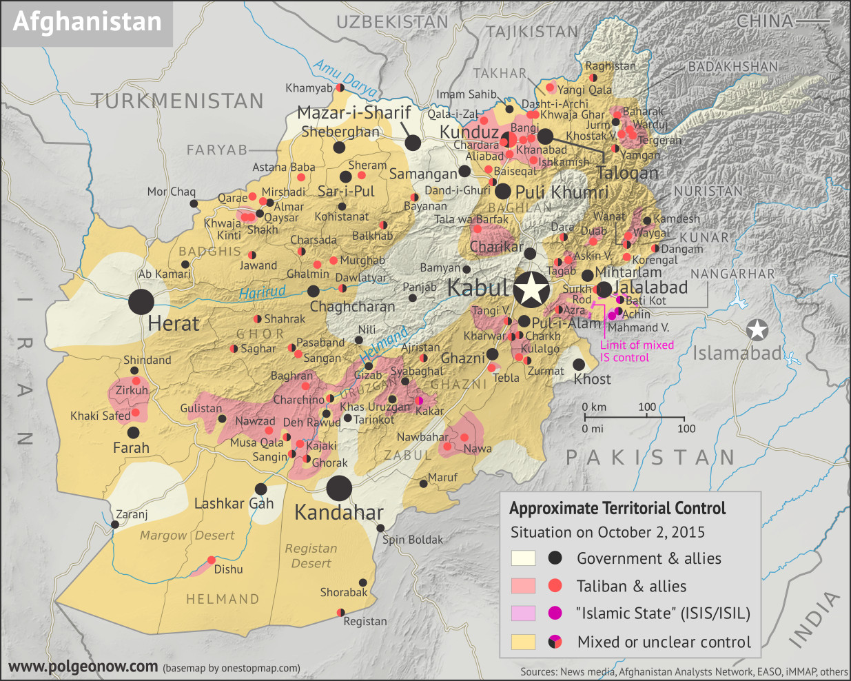
2015 in Afghanistan: Map of Taliban and "Islamic State" Control

Hidden image for crawlers (To see other maps in this series, view all Afghanistan updates.)

Welcome to PolGeoNow's new series of Afghanistan control maps! In the coming months, we'll publish more maps and timelines spanning the gap between 2015 and 2019, leading into routine updates of the current situation. To secure your access to all future installments, sign up now for our professional conflict map subscription service!


Where in Afghanistan is the war? Map of Taliban control in Afghanistan in October 2015, during the Taliban's takeover of Kunduz city and at the height of so-called Islamic State (ISIS/ISIL) control in Nangharhar province. Also marks areas of government control and unclear or mixed control. Includes all of Afghanistan's major cities, plus selected towns, including many sites of Taliban control. Colorblind accessible.
Basemap by Koen Adams of onestopmap.com, with territorial control by Evan Centanni.
Contact us for permission to use this map.


(Subscribers click here to view this article on the member site)

Timeline by Evan Centanni

Afghanistan: Who Controlled What in 2015?

The date is October 2, 2015. In the year and a half since the low point of Taliban control shown in our April 2014 Afghanistan map, the rebel group has been steadily expanding its territory. Most recently, the Taliban have launched a surprise takeover of Kunduz city, one of northern Afghanistan's major population centers, and the first provincial capital they've controlled since their national government was overthrown in 2001. Meanwhile, as the current government pours all its resources into taking the city back, the Taliban take advantage of the chaos to seize control of various other districts across the Afghan countryside.

Meanwhile, the so-called "Islamic State" (IS; formerly ISIS/ISIL), based thousands of kilometers to the west in Iraq and Syria, has established a formidable new branch in Afghanistan. This IS affiliate - known officially as "Khorasan Province" - has carved out a small territory of its own in Nangarhar, along the border with Pakistan, and is now reaching what will be the height of its power in Afghanistan. Though both IS and the Taliban are religious hardliners, IS's brutal tactics, largely foreign membership, and claimed superiority have made it an enemy of the Taliban, and left it with very little support among the Afghan people.

Thursday, November 29, 2018

Afghanistan: Map of Taliban Control in April 2014

There are newer versions of this map available. To see them, view all Afghanistan updates.

Welcome to PolGeoNow's brand new series of Afghanistan control maps! In the coming months, we'll publish more maps spanning the gap between 2014 and 2018, leading into routine updates of the current situation. To secure your access to all future installments, sign up now for our professional conflict map subscription service!

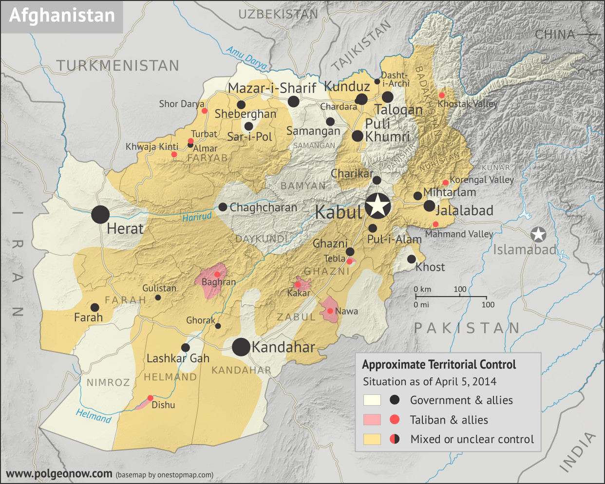
Where in Afghanistan is the war? Map of Taliban control in Afghanistan in April 2014, after the troop surge and before withdrawal was completed. Also marks areas of government control and unclear or mixed control. Includes all of Afghanistan's major cities, plus selected towns, including the four districts known to be controlled by the Taliban at the time: Dishu and Baghran in Helmand province, Kakar (Khak-e-Afghan) in Zabul province, and Nawa in Ghazni province. Colorblind accessible.
Basemap by Koen Adams of onestopmap.com, with territorial control by Evan Centanni.
This map has been slightly revised. You can see the original here. Contact us for permission to use this map.
(Subscribers click here to view this article on the member site)

Article by Evan Centanni

Afghanistan: Who Controlled What in 2014?

The date is April 5, 2014. It's been more than 12 years since a US-led invasion helped overthrow the Taliban's Islamic Emirate of Afghanistan, a religious hardline government that ruled most of the mountainous country from 1996 to 2001. Its successor, the NATO-backed Islamic Republic of Afghanistan, is voting today on a replacement for President Hamid Karzai, who has led the country ever since the Taliban government's fall in 2001.

Monday, March 20, 2017

2016 Year in Review: Rebel Control Around the World

The rebel control maps in this article were produced for PolGeoNow's professional conflict map subscription service. Full-size versions of all PolGeoNow conflict maps, along with territorial control timelines, are accessible to subscribers. You can learn more about our map subscriptions here. Non-subscribers can also view our collection of free sample control map reports.

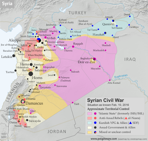
Map of fighting and territorial control in Syria's Civil War (Free Syrian Army rebels, Kurdish YPG, Syrian Democratic Forces (SDF), Al-Nusra Front, Islamic State (ISIS/ISIL), and others), updated for February 2016. Now includes terrain and major roads (highways). Highlights recent locations of conflict and territorial control changes, such as Menagh airbase, northern Aleppo, Salma, Rabia, Nubl, Baghaliya, Tishrin Dam, and more.
Syria in February 2016

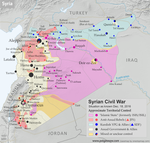
Map of fighting and territorial control in Syria's Civil War (Free Syrian Army rebels, Kurdish YPG, Syrian Democratic Forces (SDF), Jabhat Fateh al-Sham (Al-Nusra Front), Islamic State (ISIS/ISIL), and others), updated to December 18, 2016. Now includes terrain and major roads (highways). Includes recent locations of conflict and territorial control changes, such as Aleppo, Palmyra, Khan al-Shih, Mayda'ani, and more. Colorblind accessible.
Syria in December 2016

The Year in Territorial Control Changes

For the past three years, PolGeoNow has published a "Year in Review" article to summarize all the political geography news that's happened in the past 12 months. The 2014 and 2015 articles included news about changing territorial control in conflict zones, but because this is a major topic of its own, we've chosen to split these events into a separate article for 2016. So read on for a concise summary of last year's rebel control changes...

See Also: 2016 Year in Review: Country & Border Changes 
 

Syria, Iraq, and the "Islamic State"

The Syrian Civil War continued to be the biggest armed conflict in the world through 2016, as well as a prominent example of a country whose territory isn't all controlled by the recognized government. During the past year, pro-government forces scored some major victories against the rebels, recapturing the country's second largest city and gradually increasing control in areas around the capital.