 |
Map graphic by Louis Martin-Vézian and Evan Centanni (click to enlarge). All rights reserved.
|
This map has also been posted at CIGeography and CIMSEC.
Following this story? View all Yemen maps on PolGeoNow.
Updates on the world's countries and borders
|
Map graphic by Louis Martin-Vézian and Evan Centanni (click to enlarge). All rights reserved.
|

Download PDF buy |
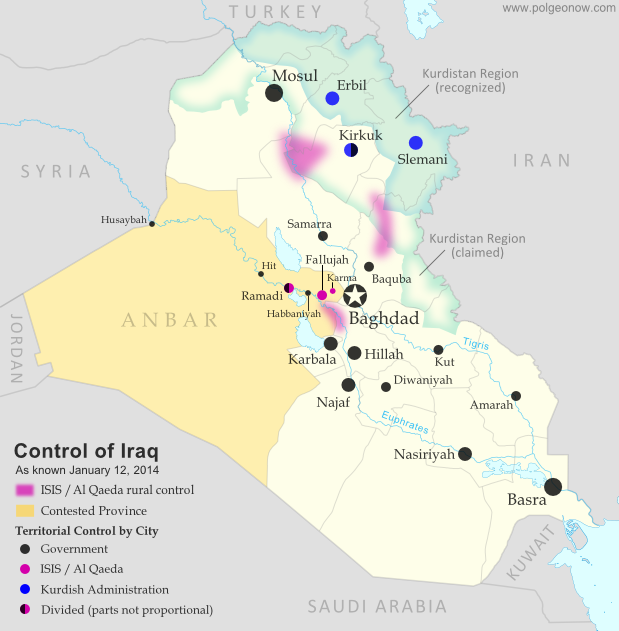 |
Territorial control in Iraq at the beginning of 2014. Map by Evan Centanni, starting from this blank map by German Wikipedia user NordNordWest. License: CC BY-SA
|
 |
Area of fighting and territorial control in Syria's civil war, updated for December 2013. Map by Evan Centanni, starting from this blank map by German Wikipedia user NordNordWest. License: CC BY-SA
|
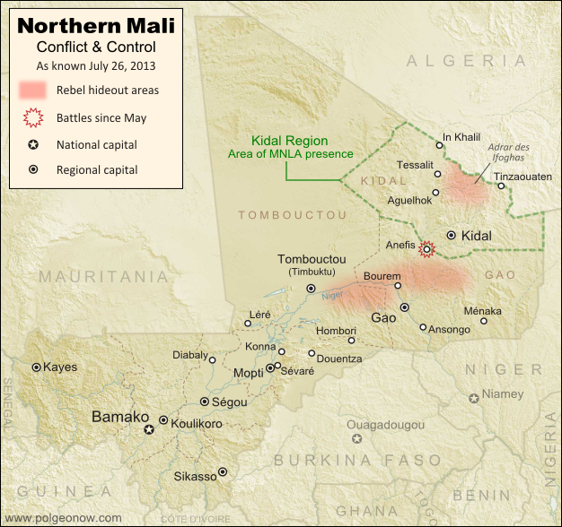 |
Updated map of situation in Mali ahead of elections on July 28, 2013. Map by Evan Centanni, modified from Wikimedia map by Orionist, using images by Carport and NordNordWest (source). License: CC BY-SA.
|
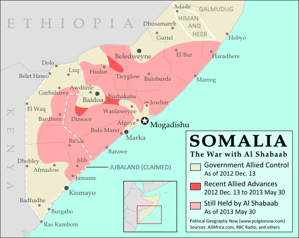 |
| Southern Somalia: recent government-allied advances in the war against Al Shabaab. Original map by Evan Centanni. Incorporates elements from this blank map by Eric Gaba and this locator map by TheEmirr. (license: CC BY-SA). |
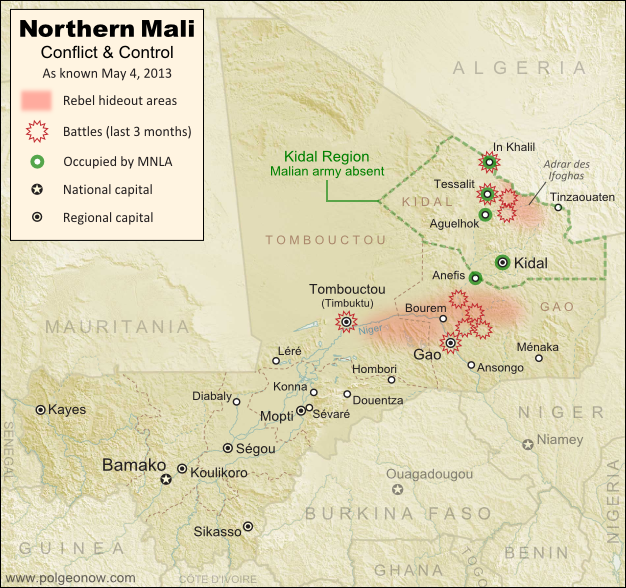 |
Updated map of territorial control and fighting in Mali, as of May 4, 2013. Map by Evan Centanni, modified from Wikimedia map by Orionist, using images by Carport and NordNordWest (source). License: CC BY-SA.
|
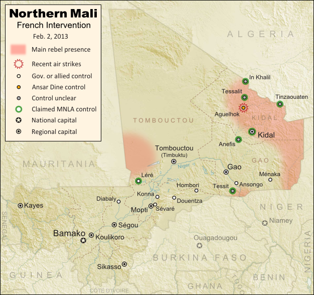 |
Updated map of territorial control and airstrikes in Mali, as of Feb. 2, 2013. Map by Evan Centanni, modified from Wikimedia map by Orionist, using images by Carport and NordNordWest (source). License: CC BY-SA.
|
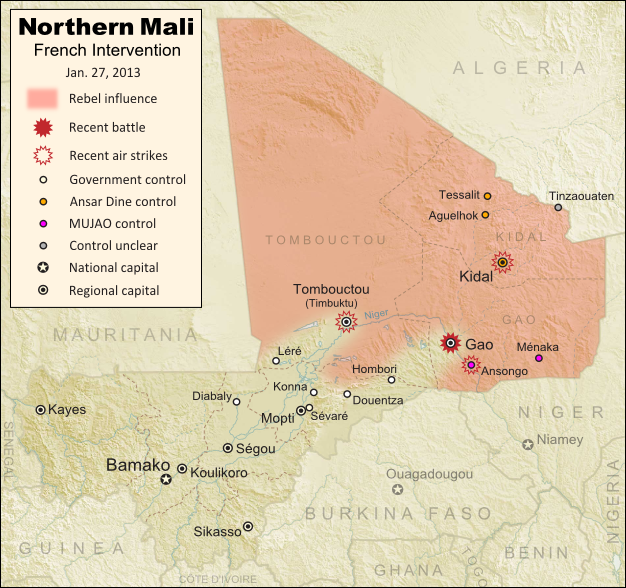 |
Updated map of territorial control and fighting in Mali, as of Jan. 27, 2013. Map by Evan Centanni, modified from Wikimedia map by Orionist, using images by Carport and NordNordWest (source). License: CC BY-SA.
|
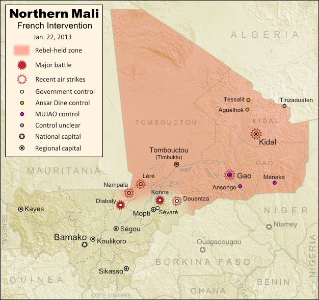 |
Updated map of territorial control and fighting in Mali, as of Jan. 22, 2013. Map by Evan Centanni, modified from Wikimedia map by Orionist, using images by Carport and NordNordWest (source). License: CC BY-SA.
|
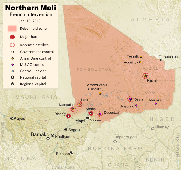 |
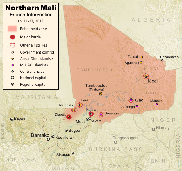
Updated map of territorial control and fighting in Mali, as of Jan. 18, 2013. Map by Evan Centanni, modified from Wikimedia map by Orionist, using images by Carport and NordNordWest (source). License: CC BY-SA.
|
 |
Current territorial control and fighting in Mali (including French intervention). Map by Evan Centanni, modified from Wikimedia map by Orionist, using images by Carport and NordNordWest (source). License: CC BY-SA.
|
 |
| Southern Somalia: recent government-allied advances against Al Shabaab. Original map by Evan Centanni. Incorporates elements from this blank map by Eric Gaba and this locator map by TheEmirr. (license: CC BY-SA). |
 |
| The retreat of the Al Shabaab Islamist militant group in Somalia since 2011. Original map by Evan Centanni. Incorporates elements from this blank map by Eric Gaba and this locator map by TheEmirr. (license: CC BY-SA). |
 |
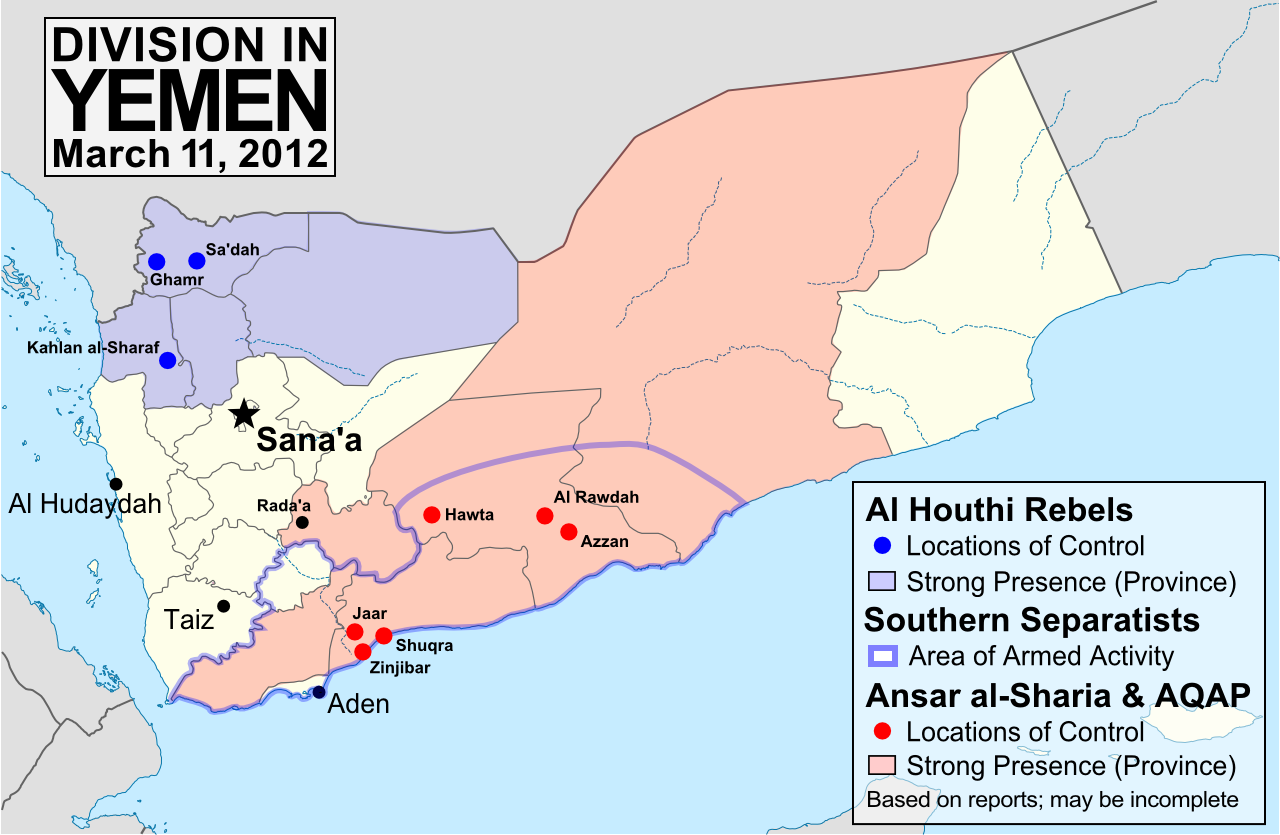
| Presence of rebel forces in Yemen as of September 2012. Ansar al-Sharia is part of Al-Qaeda in the Arabian Peninsula (AQAP). Map by Evan Centanni, using this blank map by NordNordWest/Wikipedia (license: CC BY-SA). |
 |
Area held by Islamist rebel groups Ansar Dine and MUJWA in northern Mali. Map by Evan Centanni, modified from Wikimedia map by Orionist, using images by Carport and NordNordWest (source). License: CC BY-SA.
|
 |
| Presence of anti-government forces in Yemen in June 2012. Ansar al-Sharia is part of Al-Qaeda in the Arabian Peninsula (AQAP). Map by Evan Centanni, using this blank map by NordNordWest/Wikipedia (license: CC BY-SA). |
 |
| Major areas of non-government control in Yemen, held by armed groups resistant to the country's recent power-sharing deal. Ansar al-Sharia and Al-Qaeda in the Arabian Peninsula (AQAP) are two related Islamic extremist groups. Map is my own work, from this blank map by Wikipedia user NordNordWest (license: CC BY-SA) |
 |
| Territory and areas of influence for rebels (blue) and Islamic extremists (red) in Yemen. Map is my own work, starting from this map by German Wikipedia user NordNordWest (license: CC BY-SA). (Corrected November 20, 2011) |
 |
Map showing most of the Cooch Behar |
 |
| Location of Rastan within Syria. Based on this map by German Wikipedia user NordNordWest. License: CC BY-SA |
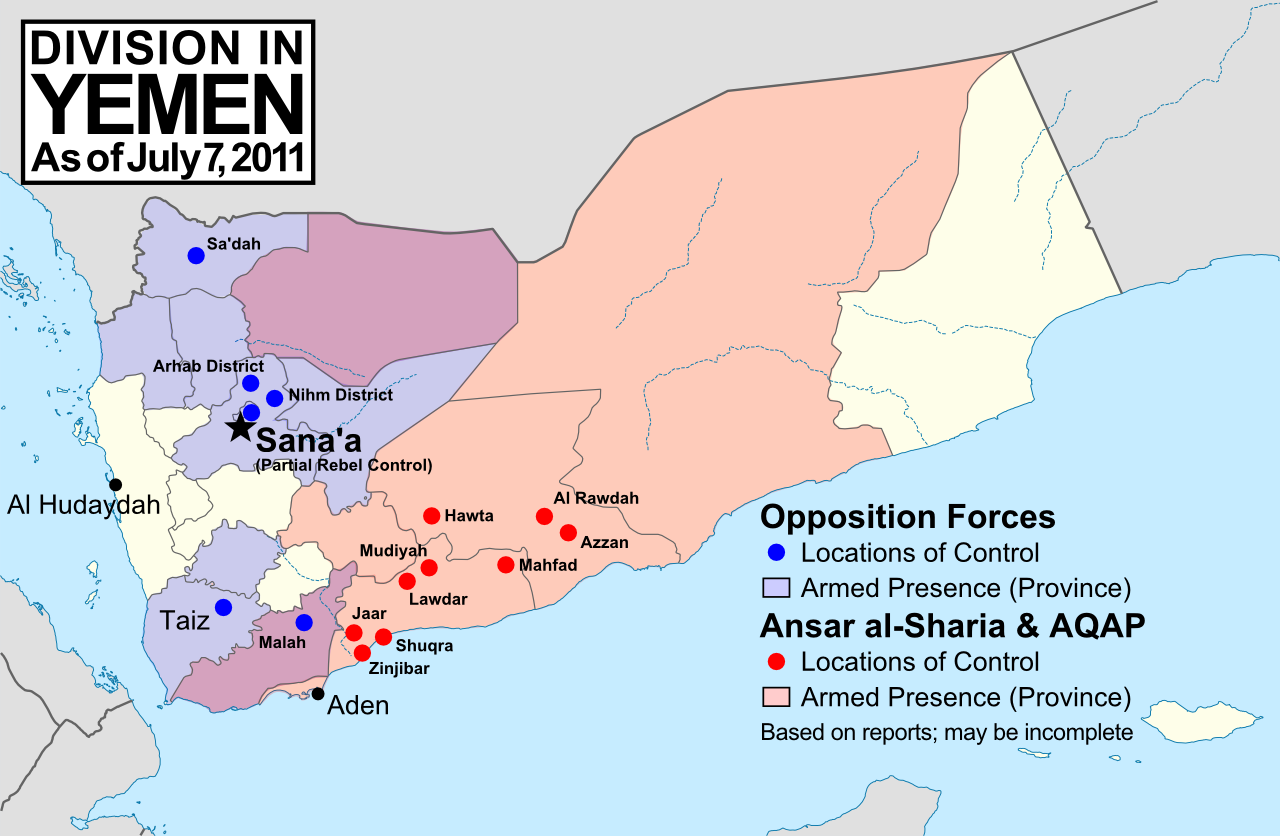 |
| Rebel and Islamic extremist control in Yemen, according to news reports. Ansar al-Sharia and Al-Qaeda in the Arabian Peninsula (AQAP) are two related Islamic extremist groups. Unarmed protests not shown. Map is my own work, based on this map by Wikipedia user NordNordWest (license: CC BY-SA). (Corrected: Nov. 20, 2011) |
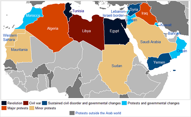 |
| The series of 2011 protests and revolutions in the Arab world is sometimes called the "Arab Spring". Yemen is located at the lower right. Map is from this Wikipedia page (public domain; original graphic). |