Showing posts with label al qaeda. Show all posts

Sunday, January 12, 2014

Iraq: Map of Al Qaeda Control

There are newer versions of this map available. To see them, view all Iraq updates.

PolGeoNow presents our first map of Iraq, showing control by the government and Al Qaeda rebels in the country's ongoing crisis. Areas of autonomous Kurdish administration in the north are also indicated.

Want to see timely updates for this map? Subscribe to our premium member service!

Map of territorial control in Iraq in January 2014, including cities and countryside held by Al Qaeda (ISIS) as well as areas administered by Kurdistan
Territorial control in Iraq at the beginning of 2014. Map by Evan Centanni, starting from this blank map by German Wikipedia user NordNordWest. License: CC BY-SA
Premium members click here to view this article in the ad-free members area. Not a member yet? Subscribe now!

By Evan Centanni


Al Qaeda in Iraq
Though the reality is of course more complex, power politics in Iraq often revolve around the country's three largest ethnic groups: Shia (Shiite) Arabs, Sunni Arabs, and Kurds (most Kurds are religiously Sunni, but their language and cultural distinguish them from Arabs). Prime Minister Nouri al-Maliki, a Shia Arab, is often accused of manipulating Iraq's democracy to exclusively serve the country's Shia majority. The Kurds govern a highly autonomous region in the northeast, but the Sunni Arabs who dominate northwestern Iraq have relatively little political power. Into the fray has jumped Al Qaeda in Iraq, now part of the Islamic State of Iraq and al-Sham (ISIS) organization which also controls parts of Syria (map). Al Qaeda has waged a fierce campaign against the Iraqi government in the name of Sunnis, though the group is still rejected by many of the people it claims to protect.

Saturday, December 14, 2013

Syria Civil War Map: December 2013 (#12)

There are newer versions of this map available. To see them, view all Syria updates.

In addition to updates on the situation, our updated Syria control map now distinguishes the territory of extremist groups ISIS and Al-Nusra from that of Free Syrian Army or mixed rebel coalitions. (To see other maps in this series, view all Syria updates.)

Tired of waiting months for Syria map updates and briefings? Subscribers to our premium member service will soon begin seeing much more frequent Syria control updates. Don't miss out - sign up now!

Map of fighting and territorial control in Syria's Civil War (Free Syrian Army rebels, Kurdish groups, Al-Nusra Front, ISIS/ISIL and others), updated for December 2013. Includes recent locations of conflict and territorial control changes, Al-Safira, Khanaser, Maaloula, Qara, Nabek, and .
Area of fighting and territorial control in Syria's civil war, updated for December 2013. Map by Evan Centanni, starting from this blank map by German Wikipedia user NordNordWest. License: CC BY-SA
Premium members click here to view this article in the ad-free members area. Not a member yet? Subscribe now!

Al-Nusra and the ISIS
In addition to updates on the situation since our previous Syria war map, this edition of the map also shows which cities are controlled primarily by religious extremist groups the Al-Nusra Front and the Islamic State of Iraq and Syria (ISIS) (also translated from Arabic as ISIL, the Islamic State of Iraq and the Levant). While these groups share many of their goals with the Free Syrian Army and other rebel groups fighting the Assad government, and in many cases still cooperate strategically with those groups, they are increasingly emerging as a separate bloc in the multi-sided conflict.

Saturday, July 27, 2013

Mali Conflict Map: National Territory Reunited Ahead of Elections (July 2013)

There are newer versions of this map available. To see them, view all Mali maps. 


This is an update within our Mali conflict map series - for the original story, see Mali Map: Islamist Control & French Intervention

Updated map of fighting and territorial control in Mali during the 2013 French and African intervention against Islamist rebel groups MUJAO, Ansar Dine, and Al Qaeda in the Islamic Maghreb (AQIM). Reflects the situation as of July 27, 2013, including the Kidal region claimed by the Tuareg rebels of the National Movement for the Liberation of Azawad (MNLA).
Updated map of situation in Mali ahead of elections on July 28, 2013. Map by Evan Centanni, modified from Wikimedia map by Orionist, using images by Carport and NordNordWest (source). License: CC BY-SA.

Thursday, May 30, 2013

War in Somalia: Map of Al Shabaab Control (June 2013)

There are newer versions of this map available. To see them, view all Somalia articles on PolGeoNow.

Since the beginning of the year, Somalia's federal government and its allies have made some major breakthroughs in the war to take back the country from Al Shabaab, Somalia's local branch of Al Qaeda. This is the third installment in our series of Al Shabaab control maps, marking territorial changes since our last Somalia map update in December 2012.

Map of Al Shabaab control in southern Somalia just before June 2013, highlighting recent advances by government and African Union troops since December. Includes the newly recaptured Mogadishu-Baidoa highway corridor, plus Bulo Marer, site of crashed U.S. drone aircraft. Also marks claimed territory of Jubaland state.
Southern Somalia: recent government-allied advances in the war against Al Shabaab. Original map by Evan Centanni. Incorporates elements from this blank map by Eric Gaba and this locator map by TheEmirr. (license: CC BY-SA).

Connecting Mogadishu and Baidoa
After news came in of the Somali Federal Government and its allies completing their control of southern Somalia's major cities last fall, further progress against the Al Qaeda affiliate group Al Shabaab at first made only slow progress. But since the beginning of this year, at least one major breakthrough has been made.

Friday, May 3, 2013

Mali Conflict Map: Hardline Rebels on the Run, Separatists Rebounding (May 2013)

There are newer versions of this map available. To see them, view all Mali maps.  


This is an update within our Mali conflict map series - for the original story, see Mali Map: Islamist Control & French Intervention.

Updated map of fighting and territorial control in Mali during the 2013 French and African intervention against Islamist rebel groups MUJAO, Ansar Dine, and Al Qaeda in the Islamic Maghreb (AQIM). Reflects the situation as of May 4, 2013, including areas occupied by Tuareg rebels of the National Movement for the Liberation of Azawad (MNLA).
Updated map of territorial control and fighting in Mali, as of May 4, 2013. Map by Evan Centanni, modified from Wikimedia map by Orionist, using images by Carport and NordNordWest (source). License: CC BY-SA.
Towns Cleared of Islamist Rebels
Since our last Mali update in February, the country's religious extremist rebel groups have continued their retreat from the northern cities that they controlled for half a year. The military intervention by France and Mali's neighbors has somewhat reunited the country, though with some important exceptions.

Saturday, February 2, 2013

Mali Conflict Map: French Take Kidal, Other Towns (February 2013)

There are newer versions of this map available. To see them, view all Mali maps.  


This is an update of our Mali conflict map - for the original story, see Mali Map: Islamist Control & French Intervention.

Updated map of fighting and territorial control in Mali during the January-February 2013 French intervention against the Islamist extremist rebel groups Ansar Dine and MUJAO. Reflects the situation as of February 2, when Kidal and other towns have been captured by French and African forces.
Updated map of territorial control and airstrikes in Mali, as of Feb. 2, 2013. Map by Evan Centanni, modified from Wikimedia map by Orionist, using images by Carport and NordNordWest (source). License: CC BY-SA.
French Troops Secure Kidal
After taking the two largest cities in Mali's north over the last week, the French military by Thursday had also secured Kidal, the last of the area's three major regional centers. The religious extremist rebels of Ansar Dine had apparently already fled the city, which was instead occupied by two moderate rebel organizations, the MIA and the MNLA, the latter of which originally took over the north last spring before being driven out by religious extremist groups.

Sunday, January 27, 2013

Mali Conflict Map: Gao and Timbuktu Retaken (January 2013)

There are newer versions of this map available. To see them, view all Mali maps.   

This is an update of our Mali conflict map - for the original story, see Mali Map: Islamist Control & French Intervention.

Updated map of fighting and territorial control in Mali during the January 2013 French intervention against the Islamist forces of Ansar Dine and MUJAO. Reflects the Jan. 26-27 recapture of major northern cities Gao and Timbuktu by French and Malian forces.
Updated map of territorial control and fighting in Mali, as of Jan. 27, 2013. Map by Evan Centanni, modified from Wikimedia map by Orionist, using images by Carport and NordNordWest (source). License: CC BY-SA.
French-Malian troops capture two major northern cities
Events have proceeded quickly in Mali's ongoing war since the France's military intervention against radical Islamist rebels began just over two weeks ago. This weekend, French and Malian troops recaptured Gao and Timbuktu, two of the three major towns seized by separatist rebels last spring and taken over by radical right-wing militias a few months later.

Tuesday, January 22, 2013

Mali Conflict Map: Douentza Secured by Government (January 2013)

There are newer versions of this map available. To see them, view all Mali maps.   

This is an update of last week's Mali conflict map - for the full story, see Mali Map: Islamist Control & French Intervention.

Updated map of fighting and territorial control in Mali during the January 2013 French intervention against the Islamist forces of Ansar Dine and MUJAO. Reflects the Jan. 21 recapture of central town Douentza by French and Malian forces.
Updated map of territorial control and fighting in Mali, as of Jan. 22, 2013. Map by Evan Centanni, modified from Wikimedia map by Orionist, using images by Carport and NordNordWest (source). License: CC BY-SA.
Key Central Town under French-Malian control
The ongoing French-led war against right-wing Islamic insurgents in northern Mali has achieved another victory. Douentza, probably the most important of the central Malian towns formerly held by the rebels, has now been secured by government and French forces. The allied troops reportedly found that the rebels had already left ahead of them, presumably fleeing the French airstrikes that targeted the town over the last week.

Friday, January 18, 2013

Mali Conflict Map: Hardline Rebels Lose Two Towns (January 2013)

There are newer versions of this map available. To see them, view all Mali maps.   

This is an update of yesterday's Mali conflict map - for the full story, see Mali Map: Islamist Control & French Intervention.

Updated map of fighting and territorial control in Mali during the January 2013 French intervention against the Islamist forces of Ansar Dine and MUJAO. Reflects the Jan. 18 recapture of Konna and Diabaly towns by French and Malian forces.
Updated map of territorial control and fighting in Mali, as of Jan. 18, 2013. Map by Evan Centanni, modified from Wikimedia map by Orionist, using images by Carport and NordNordWest (source). License: CC BY-SA.
Rebels Lose 2 Towns to French-Malian Forces
The French intervention in Mali has finally resulted in territorial gains for the government, after the two central towns of Konna and Diabaly were reportedly retaken by French and Malian troops today. Mali had incorrectly claimed the recapture of Konna earlier this week, and Diabaly was actually seized by the Islamic extremist rebels after French forces arrived. Local sources have now confirmed both towns to be under government control.

Also today, troops from a Nigerian-led West African force finally began arriving in the country (though they have not yet joined in the combat). Meanwhile, a hostage crisis continued into its third day in neighboring Algeria, where militants closely linked to Al Qaeda have taken over a natural gas field and captured its crew of international workers. By some accounts the militants have demanded an end to the French intervention in Mali, though the location of the gas field is far from Mali's borders, and they are believed to have attacked from within Algeria.

Full Story: Mali Map: Islamist Control & French Intervention

Thursday, January 17, 2013

Mali Conflict Map: France Begins Intervention Against Religious Hardline Rebels (January 2013)

There are newer versions of this map available. To see them, view all Mali maps.   

Islamic extremist militants have ruled Mali's vast northern region almost unopposed for half a year, after driving out the secular Tuareg-majority separatists who briefly declared an independent country there last spring. But everything changed last weekend, with a new rebel offensive and surprise French military intervention that have kicked the war back into full gear. Read on for a summary of events.

Map of fighting and territorial control in Mali during the January 2013 French intervention against the Islamist forces of Ansar Dine and MUJAO
Current territorial control and fighting in Mali (including French intervention). Map by Evan Centanni, modified from Wikimedia map by Orionist, using images by Carport and NordNordWest (source). License: CC BY-SA.
Map Updates: Check our Mali channel for frequent updates to this map.

Northern Mali in Rebel Hands
The rebellion in northern Mali began as a separatist struggle led by the National Movement for the Liberation of Azawad (MNLA), a secular group of mostly Tuareg ethnicity who last spring successfully seized Mali's north and declared independence as the State of Azawad. But their victory was soon hijacked by Ansar Dine, a hard-line Islamist militia (also led by Tuaregs) that had fought alongside them previously. Ansar Dine was then joined by MUJAO, an Al Qaeda offshoot group, who swiftly expelled the MNLA from the region. (See: Independent Azawad No More: Northern Mali in Islamist Hands)

Thursday, December 13, 2012

Somalia: Al Shabaab Map Update (Dec. 2012)

There are newer versions of this map available. To see them, view all Somalia articles on PolGeoNow.

Al Shabaab, Somalia's local branch of Al Qaeda, has continued to gradually lose territory since government-allied forces captured its main stronghold two months ago. As a follow-up to our October feature on the two-year retreat of Al Shabaab, we now present the latest changes to the map of control in southern Somalia.

Map of Al Shabaab control in southern Somalia as of December 2012, highlighting recent advances by government and African Union troops since the capture of key port city Kismayo. Includes the December capture of Jowhar by Ugandan AU forces.
Southern Somalia: recent government-allied advances against Al Shabaab. Original map by Evan Centanni. Incorporates elements from this blank map by Eric Gaba and this locator map by TheEmirr. (license: CC BY-SA).


Slow Progress Against Al Shabaab
Somalia's Islamic extremist militia, Al Shabaab, was greatly weakened when its biggest port and de facto capital of Kismayo was taken by government-allied African Union (AU) forces in October (See: The Retreat of Al Shabaab). However, it still controls a significant amount of territory, and the Somali and AU forces' advance has been slow, with their first major territorial gain acheived only this past weekend.

Tuesday, October 9, 2012

Somalia: The Retreat of Al Shabaab

There are newer versions of this map available. To see them, view all Somalia articles on PolGeoNow. 


One year ago, Kenya and Ethiopia invaded Somalia to end the rule of Al Shabaab, an Al Qaeda allied extremist group which had taken over the southern half of the country. This map and article are your guide to the militants' slow but steady retreat, culminating in last week's capture of the port city of Kismayo.

Map of the retreat of Al Shabaab Islamist militants in Somalia since 2011, culminating in the October 2012 capture of the key port city of Kismayo. Shows successive stages of advance by Kenyan, Ethiopian, and local forces.
The retreat of the Al Shabaab Islamist militant group in Somalia since 2011. Original map by Evan Centanni. Incorporates elements from this blank map by Eric Gaba and this locator map by TheEmirr. (license: CC BY-SA).

State of Anarchy
Located at the tip of East Africa's "Horn", Somalia has been wracked by chaos and violence since the fall of its last effective national government in 1991. While the northern Somaliland and Puntland regions formed autonomous governments, central and southern Somalia were ruled for many years by a patchwork of local warlords.

Friday, September 21, 2012

Yemen Conflict Map: September 2012 (#4)

Since June, the Yemeni government has completed its campaign to free the south from Al Qaeda rule, but multiple rebel movements remain active. Keep reading for a summary of the current situation. (To see other maps in this series, view all Yemen updates.)

Map of current division in Yemen, including Al Qaeda or Ansar al-Sharia activity, Houthi rebel control, and the location of the Southern Movement insurgency. Update for September 2012.
Presence of rebel forces in Yemen as of September 2012. Ansar al-Sharia is part of Al-Qaeda in the Arabian Peninsula (AQAP). Map by Evan Centanni, using this blank map by NordNordWest/Wikipedia (license: CC BY-SA).


Thursday, September 6, 2012

Independent Azawad No More: Northern Mali in Islamist Hands

There are newer versions of this map available. To see them, view all Mali maps.   

Since declaring the independence of Azawad in April, control by northern Mali's MNLA rebels has been usurped by the hardline Islamists of Ansar Dine and MUJAO. The new regime, while still bitter enemies of the Malian government, does not claim independence. Presented here is a map and brief guide explaining the current situation.

Map of Islamist rebel control in northern Mali as of September 2012
Area held by Islamist rebel groups Ansar Dine and MUJWA in northern Mali. Map by Evan Centanni, modified from Wikimedia map by Orionist, using images by Carport and NordNordWest (source). License: CC BY-SA.
Separatists vs. Islamists
Last April, the Tuareg-dominated separatists of the National Movement for the Liberation of Azawad (MNLA) swept into victory in northern Mali, completing their control of the region and declaring independence as the State of Azawad. But their victory was won only with the support of Ansar Dine, an Islamist militia led by veteran Tuareg fighter Iyad Ag Ghaly. The MNLA and Ansar Dine then alternated between cooperation and conflict for months, with the Islamists grabbing ever more control of the region's cities.

Saturday, June 16, 2012

Yemen Conflict: Map Update 3

Fighting between Yemen's transitional government and Al Qaeda branch Ansar al-Sharia reached a climax this week, as government forces captured the militants' strongholds in Abyan province. This article gives a rundown of recent events and the current situation in divided Yemen.

Map of division in Yemen, including control by Al Qaeda or Ansar al-Sharia, the Houthi rebels, and the Southern Movement. Update for June 2012.
Presence of anti-government forces in Yemen in June 2012. Ansar al-Sharia is part of Al-Qaeda in the Arabian Peninsula (AQAP). Map by Evan Centanni, using this blank map by NordNordWest/Wikipedia (license: CC BY-SA).


Sunday, March 11, 2012

Map Update: Yemen Conflict

Country Name: Yemen (English), Al Yaman (Arabic)
Official Name: Republic of Yemen (English), Al JumhĊĞriyyah al Yamaniyyah (Arabic)
News Category: Divided Countries
Summary: Despite a negotiated end to its political crisis, Yemen is still deeply divided between the official government and at least three separate armed groups which existed even before the recent turmoil. For a description of the beginnings of Yemen's popular uprising and the first version of this conflict map from last July, see Yemen Fragments Under Uprising. A previous updated version of that map can be seen in the News Bits: October 2011 article.

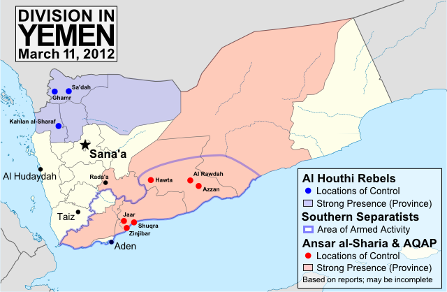
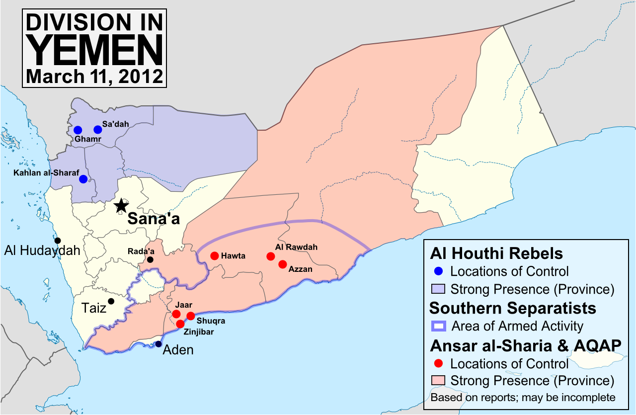
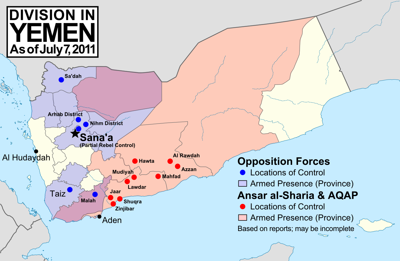
Major areas of non-government control in Yemen, held by armed groups resistant to the country's recent power-sharing deal. Ansar al-Sharia and Al-Qaeda in the Arabian Peninsula (AQAP) are two related Islamic extremist groups. Map is my own work, from this blank map by Wikipedia user NordNordWest (license: CC BY-SA)


(Note: For updates to this map, follow the Yemen label on Political Geography Now.)

Conflict Update
Since last fall, the conflict in Yemen has undergone something of a change in direction. In November President Ali Abdullah Saleh finally signed an agreement with the Joint Meeting Parties, a coalition of opposition politicians that includes Nobel Peace Prize winner Tawakkul Karman. Under the deal, brokered by the Gulf Cooperation Council, Saleh would yield the presidency in February to vice president Abd Rabbuh Mansur Al-Hadi via a symbolic election. After the power transfer went forward as planned last month, opposition militias have mostly ended their conflicts with the government, and unarmed protests have decreased (but not ended altogether). The city of Taiz, referred to as the heart of Yemen's revolution, has been largely demilitarized, and the streets of Sana'a no longer see frequent violence.

Useful Link: Timeline of the 2011–2012 Yemeni uprising (Wikipedia)

However, not all groups have fully agreed to the terms of the new arrangement. Most notably, there are three major armed groups who have been resisting the Yemeni government since long before last year's popular uprising began:

Ansar al-Sharia & Al Qaeda in the Arabian Peninsula (AQAP): These two apparently connected groups of Islamic extremists took advantage of the chaos of the revolution to carve out their own territories in southern Yemen. Ansar al-Sharia now controls much of Abyan and Shabwah provinces, including hotly contested Zinjibar, as well as its recently declared "Islamic emirates" in both Jaar (which they renamed Waqar) and the eastern Shabwah region. Al Qaeda affiliate AQAP operates widely in the country, and in January briefly captured the town of Rada'a before withdrawing after negotiations with local leaders. Ansar al-Sharia and AQAP have played no part in the peace process, and are sworn enemies of nearly all other major political groups in the country.

The Al Houthi Rebels: The Houthis are a Shiite insurgent group that has fought several wars for autonomy from predominantly Sunni Yemen since 2004. During the beginnings of last year's uprising, the Houthis solidified control over their home region of Sa'dah in the far northwest of the country, and have recently extended their power to the three surrounding provinces as well. The group's leadership has called for participation in the national reconciliation process, but boycotted voting in last month's single-party election. Only time can tell whether the Houthis' territories will be integrated into Yemen or again erupt into full-blown rebellion.

The Southern Separatists: Ever since North and South Yemen united in 1990, southerners wishing to re-secede have become a major political force in the country. Many of the separatists use peaceful political methods, but there are also insurgents who occasionally make attacks on the government in the name of southern independence. These separatist militants played only a small part in the uprising last year, but have recently become more active, denouncing last month's election and even going so far as to attack polling stations. Though they do not solidly control any territory, they still form a major threat to unity in Yemen.

Further Reading: Land of the Black Flag - Journalist Casey Coombs visits and photographs the Ansar al-Sharia stronghold of Jaar, the so-called "Islamic Emirate of Waqar".

Major Sources:
Yemen Post News
AEI Critical Threats 

Monday, October 24, 2011

News Bits: October 2011

"News Bits" posts cover minor political geography events from the last few months. Although the news may be of great political relevance, these events haven't (yet) affected major changes to the shapes, sovereignty, or political status of the world's countries.

Yemen: Militias Take Territory From Islamists
Territory and areas of influence for rebels (blue) and Islamic
extremists (red) in Yemen. Map is my own work, starting
from this map by German Wikipedia user NordNordWest
(license: CC BY-SA). (Corrected November 20, 2011)
In Yemen's ongoing political crisis (See: Yemen Fragments Under Uprising), some territory previously held by Islamist militants has fallen under the control of unsympathetic non-government forces, whose presence around the country seems to be expanding. The Islamists, who call themselves Ansar al-Sharia ("Partisans of Islamic Law"), have occupied the cities of Jaar, Zinjibar, and Shuqra in Abyan province for several months now, along with various smaller towns both in Abyan and in heighboring Shabwah. However, since July, many of the smaller towns have fallen into the hands of local militias, and the Yemeni government has gained ground in the Zinjibar area. Though the local militias are currently working alongside the government, it is unclear whether it may be only a temporary truce. Yemen's opposition forces are composed of a mixture of local and kinship-based militias, army defectors, and pre-existing rebel groups, which sometimes work together but are increasingly clashing among themselves. The country's third largest city, Taiz, is largely under the control of opposition forces, as are some parts of the capital, Sana'a. (More Yemen news on Political Geography Now)

Sudan No Longer Africa's Largest Country
Now that the South Sudan has gained independence (See: New Country - South Sudan), the remainder of Sudan is no longer Africa's largest country by area. Sudan's one-time top spot was  followed by Algeria in second place and the Democratic Republic of the Congo in third. However, the secession of South Sudan  removed a substantial portion of Sudan's territory, and the northern remainder of the country now ranks third in Africa - after Algeria and the DRC. South Sudan ranks 19th, out of a total of 54 U.N.-recognized countries in Africa. (Graphic my own work, based on this map by Wikipedia user Mangwanani. License: CC BY-SA)

Map showing most of the Cooch Behar
enclaves. By Dutch Wikipedia user
Jeroen (source). License: CC BY-SA
Wikipedia: List of African Countries and Territories

Indo-Bangladesh Treaty Defines Border, Trades Enclaves
A treaty signed last month between the governments of India and Bangladesh fully defines the border between the two countries, and provides for the trade of dozens of enclaves. The Indo-Bangladesh enclaves, also known as "chitmahals" or the "Cooch Behar enclaves" (after the district of India which most of them either belong to or are located inside), number well over 100, including patches of Indian territory within Bangladesh and patches of Bengladeshi territory within India. Their inhabitants have long suffered under abominable living conditions due to the fact that they have access neither to services from their own country (because of their isolation) nor to services from the country surrounding them (because they are not considered part of its territory). Under the new agreement, based on a 1974 deal that was never adopted, nearly all of the enclaves will be ceded to whichever country surrounds them, and inhabitants will have a choice of citizenship. The two parties also defined the border in several previously disputed or undemarcated areas. The treaty will not go into effect until it is ratified by both countries' legislatures.


Location of Rastan within Syria. Based on this
map
by German Wikipedia user NordNordWest.
License: CC BY-SA
Syrian City Falls Briefly to Rebels
In Syria's ongoing uprising, the city of Rastan fell under control of protester-friendly rebel forces for a few weeks last month, before ultimately being retaken by government troops. The crisis in Syria, seen as part of the so-called "Arab Spring" movement for democratic change in the Middle East, began with protests last January. By march it had escalated to widespread displays of defiance in the streets, to which the government responded by sending in tanks and soldiers. However, the resistance was mostly unarmed until army defectors began organizing against the military in September. The city of Rastan, one of several major protest centers, was taken over by anti-government forces, which were not driven out until October 1. So far there have been no more reports of Syrian cities falling under armed anti-government control, but protests and violent government crackdowns continue in full gear.

Thursday, July 7, 2011

Yemen Fragments Under Uprising

Country Name: Yemen (English), Al Yaman (Arabic)
Official Name: Republic of Yemen (English), Al JumhĊĞriyyah al Yamaniyyah (Arabic)
News Category: Divided Countries
Summary: After months of unrest and popular opposition to the government, much of Yemen's territory has fallen out of government control. Several areas are occupied by Islamist militants seeking to implement Sharia Law, while others have fallen under the control of various local groups and military defectors united in their demand for the removal of president and dictator Ali Abdullah Saleh.

Rebel and Islamic extremist control in Yemen, according to news reports. Ansar al-Sharia and Al-Qaeda in the
Arabian Peninsula (AQAP) are two related Islamic extremist groups. Unarmed protests not shown. Map is my
own work, based on this map by Wikipedia user NordNordWest (license: CC BY-SA). (Corrected: Nov. 20, 2011)
(Note: For updates to this map, follow the Yemen label on Political Geography Now.)

Full Story
When a country faces revolutionary change, the power of the people to oppose their government can result in a loss of control by the state, as opposition groups seize territory bit by bit. Despite the country maintaining international recognition as a single "nation-state", the territory claimed by the state may become divided. While in many cases this means one large rebel group taking control of a large section of the country, in other cases the territory may fragment into various scattered regions under the control of multiple groups. This is the process that has been occurring in Yemen during recent months.

Yemen is located at the tip of the Arabian Peninsula, south of Saudi Arabia. A republic made up of 20 provinces or "governorates", it is the only country on the Arabian Peninsula with a democratic constitution; yet it also holds the unfortunate distinction of having the lowest standard of living of any country in the Arab world. Like many other allegedly democratic countries, Yemen has remained under the tight control of a single "president", Ali Abdullah Saleh, for more than 30 years. The current unrest began in January of this year, as part of the "Arab Spring" movement that has seen protests across the Arab world and beyond, and which early on resulted in the overthrow of governments in Tunisia and Egypt. After months of protests, crackdowns, and stalled negotiations in Yemen, an armed uprising erupted in late May.

Armed opposition to President Saleh's government has been undertaken by two largely separate groups. The first group is a loose coalition of "tribes" (social groups held together by family relations) and military defectors who support the peaceful protesters' goal of ousting the president. The second group is a coalition of Islamist militants calling themselves Ansar al-Sharia ("Supporters of Islamic Law"), whose objective is to create an Islamic state in Yemen. The secular opposition groups are most active in Yemen's populated western region, while Islamist activity is centered along the southern coast and in the sparsely populated regions of the east.

The series of 2011 protests and revolutions in the Arab world is sometimes called the "Arab Spring". Yemen is
located at the lower right. Map is from this Wikipedia page (public domain; original graphic).

(More Yemen news from Political Geography Now)