 |
| Countries recognizing the Republic of Kosovo in green, highlighting recent additions. Disputed recognitions in yellow. Kosovo in magenta. Map by Evan Centanni, modified from public domain graphic (source). |
Updates on the world's countries and borders
Thursday, July 24, 2014
Map Update: Kosovo Recognized by 3 More Countries in 2014 (106/193)
Premium members click here to view this article in the ad-free members area. Not a member yet? Subscribe now!
Tuesday, July 22, 2014
War in Ukraine: Detailed Map of Rebel Control in Donetsk & Luhansk (Premium)

Download PDF buy |
Since our last Ukraine update, pro-Russian rebels have captured much more territory in Donetsk and Luhansk regions, but also lost some of their early strongholds.
This map report is exclusive premium content, available to paid subscribers or for individual purchase.
Buy now (US$9.99)
Premium map includes:
- All new, detailed map of Donetsk and Luhansk regions, showing both past and current rebel control
- Indication of which districts and cities have had their administrations occupied by separatists
- Important locations of rebel military control marked
- Article with chronology of events since April, and discussion of the meaning of "control"
MEMBERS CLICK HERE TO PROCEED TO ARTICLE AND MAP
NOT A MEMBER YET? SUBSCRIBE NOW!
Thursday, July 10, 2014
Map: Yemen Joins WTO
Premium members click here to view this article in the ad-free members area. Not a member yet? Subscribe now!
 |
| Member and observer states of the World Trade Organization (WTO). Map by Evan Centanni, starting from public domain blank map (license: CC BY-NC-SA). |
Thursday, July 3, 2014
Syria Civil War: Territorial Control Map #12.3 (Premium)
There are newer versions of this map available. To see them, view all Syria updates.

This is the Syria update you've been waiting for: our new map includes not only cities, but a full illustration of territorial control for each faction in the civil war. Also includes many updates to the situation since the last edition in April.
This map and article are exclusive premium content, available to paid subscribers or for individual purchase.
Buy now (US$9.99)
Premium map includes:
Not a member yet? Subscribe Now!

Download PDF buy |
This map and article are exclusive premium content, available to paid subscribers or for individual purchase.
Buy now (US$9.99)
Premium map includes:
- Up-to-date map of current territorial control in Syria, color-coded for the Assad government, rebel groups, ISIS/Islamic State extremists, and Kurdish self-protection forces
- Detailed indication of city-by-city control, highlighting key towns relevant to current events
- Includes recent areas of fighting including Deir ez-Zor, Abu Kamal, Mayadin, Khan Shaykhun, and many more
- In-depth article summarizes changes since April, including ISIS's declaration of an Islamic caliphate, with links to the sources of information
Not a member yet? Subscribe Now!
Tuesday, June 24, 2014
Iraq's New War: Detailed Map of ISIS Takeover (Premium)
There are newer versions of this map available. To see them, view all Iraq updates.

Since our last Iraq map update
less than a month ago, the conflict has blown up with a spectacularly
successful offensive by ISIS rebels. PolGeoNow presents here our updated map
of territorial control in Iraq, more detailed and accurate than any of the maps available on news websites.
This map and article are exclusive premium content, available only to members or for individual purchase.
Buy now (US$9.99).
Premium map includes:
Not a member yet? Subscribe Now!

Download PDF buy |
This map and article are exclusive premium content, available only to members or for individual purchase.
Buy now (US$9.99).
Premium map includes:
- Territorial control in Iraq by city, color coded for government, ISIS, or Kurdistan Government
- Detail of ISIS control and attempted control of small towns, military bases, and border crossings
- Inset map with extra detail for Kirkuk province, where ISIS and Kurdish forces are facing off
- Shading showing the estimated total area of ISIS control
- Article summarizing events since May, explaining the information on the map, and providing in-line links to sources cited
Not a member yet? Subscribe Now!
Thursday, June 12, 2014
World Cup 2014: Which Countries Are (and Aren't) Members of FIFA?
There are newer versions of this explainer available. To see them, view all FIFA World Cup articles on PolGeoNow.
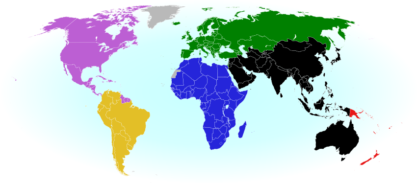 |
| The six continental confederations of national football teams associated with FIFA. Not all confederation members are individually members of FIFA. Map by Evan Centanni, based on work by EOZyo (source). |
Premium members click here to view this article in the ad-free members area. Not a member yet? Subscribe now!
Sunday, June 8, 2014
Palestine: West Bank and Gaza Reunited Under Transitional Government
(Keep up with changes to Palestine's situation: view all Palestine updates.)
Premium members click here to view this article in the ad-free members area. Not a member yet? Subscribe now!
By Evan Centanni
Unity Government
The partially-unrecognized State of Palestine is not only divided between Palestinian and Israel control - even the Palestinian-administered areas have been governed separately for several years now. However, this month rival parties Hamas and Fatah have finally come together to reunite the West Bank and Gaza Strip under a single Palestinian government.
Divided Country
The rift in control opened up in 2007, after religious militant group Hamas won a majority of seats in the 2006 Palestinian legislative elections. Hamas and Fatah, the current ruling party at the time, failed to form a stable unity government then, and the conflict between them escalated into a short civil war in the Gaza Strip.
See Also: Is Palestine Really a Country?
 |
| Control zones based on the Oslo Accords. Area A: Palestinian control; Area B: mixed Israeli-Palestinian control; Area C: full Israeli control. Map by Evan Centanni (sources: Natural Earth, B'Tselem, U.N. OCHA oPt). |
By Evan Centanni
Unity Government
The partially-unrecognized State of Palestine is not only divided between Palestinian and Israel control - even the Palestinian-administered areas have been governed separately for several years now. However, this month rival parties Hamas and Fatah have finally come together to reunite the West Bank and Gaza Strip under a single Palestinian government.
Divided Country
The rift in control opened up in 2007, after religious militant group Hamas won a majority of seats in the 2006 Palestinian legislative elections. Hamas and Fatah, the current ruling party at the time, failed to form a stable unity government then, and the conflict between them escalated into a short civil war in the Gaza Strip.
See Also: Is Palestine Really a Country?
Tuesday, May 27, 2014
Iraq: Updated Map of ISIS Control (Premium)
There are newer versions of this map available. To see them, view all Iraq updates.

This is our first update to January's map of Al Qaeda control in Iraq. The map has been expanded to show much more detail of the ongoing campaign of
control by the Islamic State of Iraq and al-Sham (ISIS), now no longer
an Al Qaeda affiliate.
This map and article are exclusive premium content, available only to members or for individual purchase. Buy now (US$9.99).
Premium map includes:
Not a member yet? Subscribe Now!

Download PDF buy |
This map and article are exclusive premium content, available only to members or for individual purchase. Buy now (US$9.99).
Premium map includes:
- Territorial control in Iraq by city, color coded for government, ISIS, or Kurdistan
- Detail of ISIS control and attempted control in small towns, including in the eastern flashpoint province of Diyala
- Inset map with extra detail for Anbar province, where ISIS controls the most populated territory
- Indications of estimated ISIS control/influence in the countryside
- Article summarizing events since January, explaining the information on the map, and providing in-line links to the sources of information
Not a member yet? Subscribe Now!
Saturday, May 3, 2014
Mayotte Enters European Union
 |
"Outermost regions" are officially part of the European Union; "overseas countries and territories" are not part of the EU itself, but have special relations with it because of their connections to member countries. New outermost region Mayotte is located in southeastern Africa. Map from Wikimedia Commons © Alexrk2 (CC BY-SA)
|
Article by Evan Centanni
EU Expands to Include Mayotte
You probably heard about Croatia joining the European Union last year, but did you know the EU expanded further this year...in Africa? The French overseas department of Mayotte, a group of islands in the Indian Ocean northwest of Madagascar, became officially part of the EU on January 1.
Thursday, April 24, 2014
Syria Civil War Map: April 2014 (#12.2) (Premium)
There are newer versions of this map available. To see them, view all Syria updates.

PolGeoNow's popular Syria civil war control maps are back! Here's the second of our member-exclusive premium updates.
Developments since our previous Syria map update in January include advances by both the government and the rebels, as well as changes in territorial control for the Islamic State of Iraq and Syria (ISIS).
This map and article are exclusive premium content, available only to members or for individual purchase. Buy now (US$9.99).
Premium article includes:
Not a member yet? Subscribe Now!

Download PDF buy |
Developments since our previous Syria map update in January include advances by both the government and the rebels, as well as changes in territorial control for the Islamic State of Iraq and Syria (ISIS).
This map and article are exclusive premium content, available only to members or for individual purchase. Buy now (US$9.99).
Premium article includes:
- Map of current territorial control in Syria by city, color-coded for the Assad government, rebel groups, ISIS extremists, and Kurdish militias
- Map includes recent areas of fighting such as Yabroud, Maloula, Kasab, Azaz, Al Bukamal, and more
- Article summarizing changes since January, with links to the sources of information
Not a member yet? Subscribe Now!
Wednesday, April 16, 2014
Ukraine Map #3: Separatist Control in the East (Premium)

Download PDF buy |
This is an up-to-date and detailed map of pro-Russian rebel and protester control in Ukraine, including the self-proclaimed "Donetsk People's Republic".
This map and article are exclusive premium content, available only to members or for individual purchase. Buy now (US$5.99).
Premium article includes:
- Ukraine control map updated for the protester occupations and armed rebel takeovers in eastern Ukraine over the past two weeks
- Shows both protester occupations and armed takeovers, as well as which regions have declared independence
- Includes a quick briefing on recent events, with links to the sources of information
Not a member yet? Subscribe Now!
Tuesday, April 15, 2014
ICYMI: The Gambia's Withdrawal from the Commonwealth
"In case you missed it" - this is an article featuring news we couldn't cover when it first broke, but that we thought you might still want to know about. Those who read our article on the year 2013 in political geography changes already heard about the Gambia's withdrawal from the Commonwealth of Nations - now here's the full story.
Premium members click here to view this article in the ad-free members area. Not a member yet? Subscribe now!
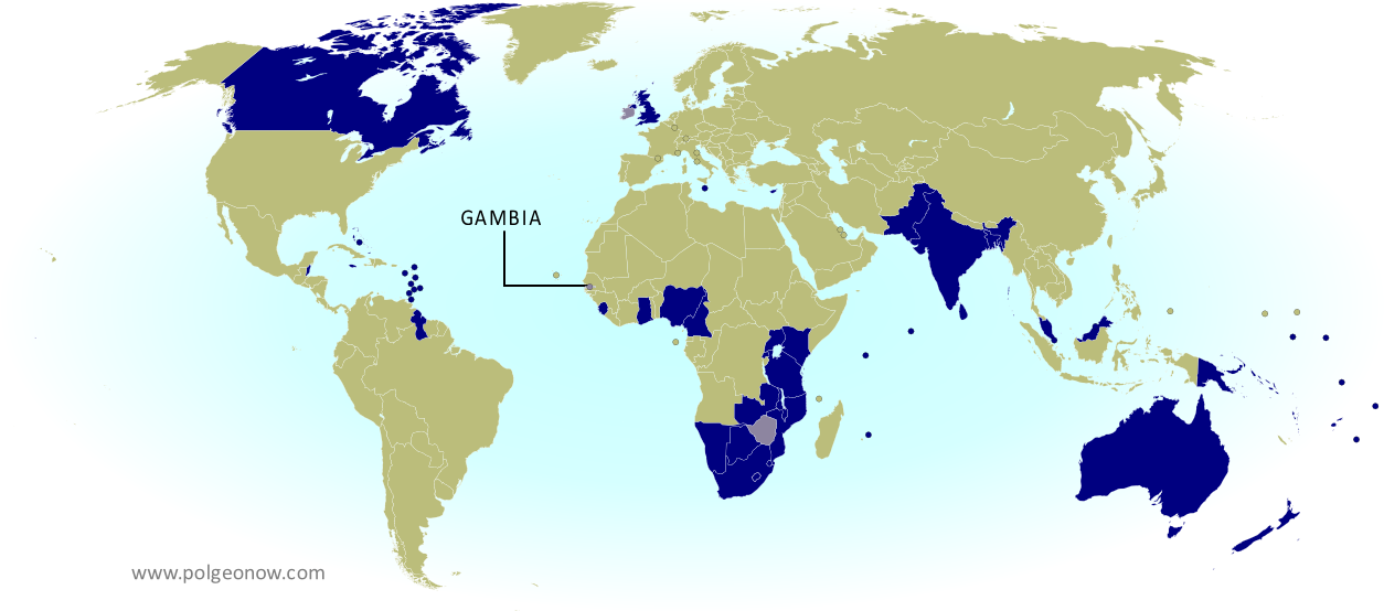 |
| The Commonwealth of Nations. Current members in dark blue, former members in lavender. Map by Evan Centanni, modified from public domain blank map. |
Saturday, April 5, 2014
Update: Ukraine Control Overview Map (Premium)

Download PDF buy |
The current article is an update on the current control situation in Ukraine from Mar. 4 to the present. This map and article are exclusive premium content, available only to members or for individual purchase. Buy now (US$5.99).
Premium article includes:
- Simple updated map of the political situation in Ukraine since Mar. 4
- Shows the last of the pro-Russian protester occupations, the annexation of Crimea, and seizures by the Ukrainian and Russian militaries outside of Crimea proper
- Report on the course of events since the last report, explaining each detail shown on the map
- In-line links to sources of information
Members click here to proceed to article and map
Not a member yet? Subscribe Now!
Thursday, March 27, 2014
Crimea Joins Russia, Gives Up Independence, Becomes Disputed Territory
Premium members click here to view this article in the ad-free members area. Not a member yet? Subscribe now!
By Evan Centanni
Russia Annexes Crimea
The Crimean peninsula, which declared independence from Ukraine ten days ago as the Republic of Crimea, has now been absorbed into Russia. This was part of the plan all along - the claimed Republic of Crimea had requested to join Russia at the same time that it declared independence.
Related: Complete Map of Locations Seized by Russia in Crimea (Premium)
 |
The claimed Republic of Crimea which has now joined Russia (click to see full-sized map). By Evan Centanni, based on this blank map.
|
Russia Annexes Crimea
The Crimean peninsula, which declared independence from Ukraine ten days ago as the Republic of Crimea, has now been absorbed into Russia. This was part of the plan all along - the claimed Republic of Crimea had requested to join Russia at the same time that it declared independence.
Related: Complete Map of Locations Seized by Russia in Crimea (Premium)
Wednesday, March 26, 2014
Premium Map Report: Russian Control of Crimea

Download PDF buy |
Premium article includes:
- Exclusive map of Russian seizure and attack locations inside and outside of Crimea
- Guide to all locations on the map, with brief summary of what has happened at each
- In-line links to sources of information
Members click here to proceed to article and map
Not a member yet? Subscribe Now!
Tuesday, March 18, 2014
Crimea Declares Independence: Is It Really a Country?
On Monday, two regional governments on the Crimean Peninsula controversially declared their independence from Ukraine as the new Republic of Crimea. While the declaration has been rejected by most of the world community, and Crimea hopes to swiftly unite with Russia, for now it might be considered a de facto sovereign state. Read on for details.
Premium members click here to view this article in the ad-free members area. Not a member yet? Subscribe now!
By Evan Centanni
Declaration of Independence
Following Ukraine's revolution, the explosion of pro-Russian protests in the east, and the subsequent occupation of the Crimean peninsula by Russian forces (see our premium report, Ukraine Map: Occupations, Autonomy, & Invasion), a new independent country has been declared on the coast of the Black Sea.
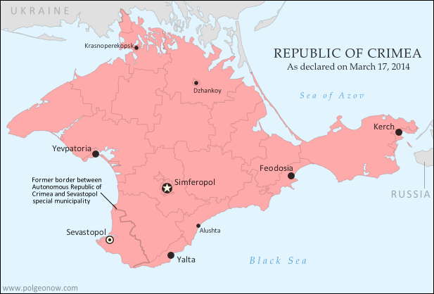 |
| The Republic of Crimea. Map by Evan Centanni, based on this blank map. |
Declaration of Independence
Following Ukraine's revolution, the explosion of pro-Russian protests in the east, and the subsequent occupation of the Crimean peninsula by Russian forces (see our premium report, Ukraine Map: Occupations, Autonomy, & Invasion), a new independent country has been declared on the coast of the Black Sea.
Saturday, March 15, 2014
Madagascar Un-Suspended from African Union
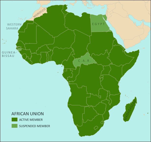 |
| The African Union as of March 2014. Map by Evan Centanni, from this blank map by Eric Gaba. License: CC BY-SA |
Saturday, March 8, 2014
How Sharply Divided is Ukraine, Really? Honest Maps of Language and Elections
There's no question that Ukraine's current crisis arose from major political divisions in the country, and it's true that language is an issue. But some online news websites have sensationalized and exaggerated these divisions through misleading maps. PolGeoNow offers a pair of maps that better communicate the blurriness of the supposed lines between western and eastern Ukraine.
(For a map of current events from January up to this week, including protester control, government occupations, and the Russian invasion, purchase our premium map of the Ukraine crisis or become a member.)
Premium members click here to view this article in the ad-free members area. Not a member yet? Subscribe now!
Article by Evan Centanni
Misleading Ukraine Maps
In January, the Washington Post's Max Fisher wrote a popular map-illustrated blog post about the political and linguistic divisions fueling Ukraine's crisis, then at the height of its pro-Europe protest phase. Later, CNN followed the Post's lead and published a similar set of maps. However, the maps in both articles are designed in a way that makes the divisions look much sharper and more black-and-white than they really are. There's not, as Fisher preposterously claims, "an actual, physical line" splitting Ukraine in half. Instead, there's a gradual shading of mixed populations whose ethnic identities and voting history don't always correlate to the country's current political divisions.
(For a map of current events from January up to this week, including protester control, government occupations, and the Russian invasion, purchase our premium map of the Ukraine crisis or become a member.)
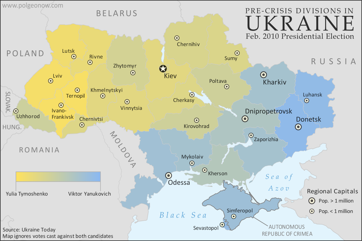 |
A more honest map of Ukraine's 2010 presidential election. By Evan Centanni.
|
Article by Evan Centanni
Misleading Ukraine Maps
In January, the Washington Post's Max Fisher wrote a popular map-illustrated blog post about the political and linguistic divisions fueling Ukraine's crisis, then at the height of its pro-Europe protest phase. Later, CNN followed the Post's lead and published a similar set of maps. However, the maps in both articles are designed in a way that makes the divisions look much sharper and more black-and-white than they really are. There's not, as Fisher preposterously claims, "an actual, physical line" splitting Ukraine in half. Instead, there's a gradual shading of mixed populations whose ethnic identities and voting history don't always correlate to the country's current political divisions.
Monday, March 3, 2014
Ukraine Map: Occupations, Autonomy, & Invasion (Premium)

Download PDF buy |
Premium article includes:
- Exclusive map of the political situation in Ukraine's 2014 crisis
- Shows protester occupations, regional capitals overrun, autonomy declarations, and locations of Russian military siege
- Report on the course of events, explaining each detail shown on the map
- In-line links to sources of information
Members click here to proceed to article and map
Not a member yet? Subscribe Now!
Saturday, February 22, 2014
South Sudan War Map: Current Rebel Control (Update #4) (Premium)

Download PDF buy |
To see the map of control at the time of the ceasefire on January 23, see Part 1.
Premium article includes:
- Exclusive map of current rebel control up to February 21, 2014
- Multiple changes to territorial control since previous update
- Several more new locations added to the map
- Report chronicling changes to territorial control since the ceasefire, including links to sources
Members click here to proceed to article and map
Not a member yet? Subscribe Now!
Subscribe to:
Posts (Atom)