Tuesday, December 14, 2021

Somalia Control Map & Timeline - December 2021

There are newer versions of this map available. To see them, view all Somalia articles on PolGeoNow.

Who controls Somalia? Map (December 2021). With states, regions, and territorial control. Best Somalia control map online, thoroughly researched, detailed but concise. Shows territorial control by Federal Government of Somalia (FGS), Al Shabaab, so-called Islamic State (ISIS/ISIL), separatist Somaliland, autonomous state Puntland, and boundaries of additional federal member states Galmudug, Jubaland, South West, and Hirshabelle. Now labels state capitals and disputed boundaries between Somaliland and Puntland, as well as key towns from recent news such as Ba'adweyne, Amara, Qey'ad, Marian Guway, Balidhidhin, and more. Updated to December 14, 2021. Colorblind accessible.
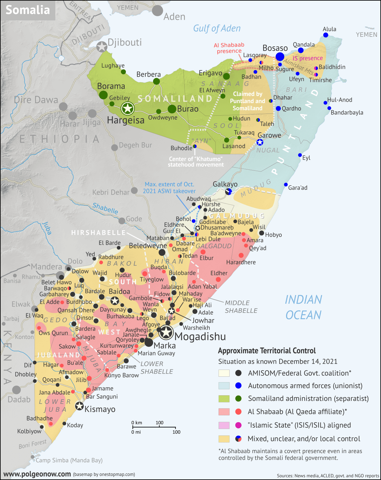
Base map by Koen Adams of onestopmap.com, with territorial control by Evan Centanni and Djordje Djukic.
Contact us for permission to use this map.

(Subscribers click here to view this article in the member area)

Timeline by Evan Centanni and Djordje Djukic

Somalia Crisis Timeline: Political and Military Disarray in 2021

In the nearly 10 months since PolGeoNow's previous Somalia control map report, the country's news cycle has been dominated by a series of interconnected political crises that have led the federal government's military to the brink of civil war. All the while, the fight against Al Qaeda affiliate Al Shabaab, which operates a parallel government across much of Somalia's countryside, has continued to see a mix of victories and defeats for each side. And while the standoff between the federal army and Jubaland state forces has ended, new regional conflicts have erupted in Hirshabelle and Galmudug states, including a major resurgence of the controversial ASWJ militia.

Read on for concise summaries of the past 10 months' political crises and military trends, followed by a detailed timeline of events since February. Sources for our reporting, and for changes to the map since last time, are covered in the detailed timeline and the additional source notes at the bottom of the page.

Saturday, December 4, 2021

Barbados Abolishes its Monarchy, Firing Queen Elizabeth

Map countries with Queen Elizabeth II as head of state, which are known as the Commonwealth realms. Includes the UK, Canada, Australia, and a number of small countries in Oceania and the Caribbean. Also shows former Commonwealth realms, including large parts of Africa and South Asia. Colorblind accessible.
Updated map of the Commonwealth realms (independent countries that share the monarchy with Britain). Click to enlarge. Contact us for permission to use this map.
 

Map showing the location of Barbados in the eastern Caribbean. A string of islands extends east from Cuba then south to the northern edge of South America, with the island of Barbados located off to the east side of the string near the southern end.
Location of Barbados in the eastern Caribbean (circled, at far right). Public domain graphic (source).
Barbados Stops Being a Commonwealth Realm

As long-time readers of PolGeoNow know, Queen Elizabeth II isn't just the queen of England and the UK, but also reigns separately over quite a few other countries known as the "Commonwealth realms". 

Until Tuesday, there were 16 independent countries recognizing Elizabeth II as their queen. But now, after the legislature of Caribbean island country Barbados voted to remove the monarchy from its constitution - effective November 30, 2021 - that number has fallen to just 15.

Queen Elizabeth's 15 Countries: The Commonwealth Realms

Did you know Elizabeth II isn't just the Queen of England and the larger UK, but of 14 other independent countries? If that statement just raises more questions for you, read on for all the answers...

Map countries with Queen Elizabeth II as head of state, which are known as the Commonwealth realms. Includes the UK, Canada, Australia, and a number of small countries in Oceania and the Caribbean. Also shows former Commonwealth realms, including large parts of Africa and South Asia. Colorblind accessible.
Map of the Commonwealth realms (independent countries that share the monarchy with Britain). Click to enlarge. Contact us for permission to use this map.


This article, originally from 2012, has been revised and updated for the abolition of Barbados's monarchy in November 2021, which reduced the number of countries Queen Elizabeth II reigns over from 16 to 15.

Which countries does Queen Elizabeth reign over?

You might be surprised to learn that Queen Elizabeth II is the official queen of 15 different independent countries. Those countries are together known as the "Commonwealth realms" - a smaller subset of the Commonwealth of Nations, which also includes many queenless republics. Every one of the 15 Commonwealth realms is considered a fully-fledged independent country and a member of the UN, despite sharing the same monarch. 

Wednesday, December 1, 2021

Yemen Control Map & Report: Hadi Forces Leave Hodeida - November 2021 (Subscription)

SUBSCRIBERS CLICK HERE TO PROCEED TO ARTICLE AND MAP

There are newer versions of this map available. To see them, view all Yemen articles on PolGeoNow.

Timeline by Djordje Djukic. Map by Evan Centanni, Djordje Djukic, and onestopmap.com

Map of what's happening in Yemen as of November 2021, including territorial control for the unrecognized Houthi government, president-in-exile Hadi and his allies in the Saudi-led coalition, and the UAE-backed southern separatist Southern Transitional Council (STC), plus major areas of operations of Al Qaeda in the Arabian Peninsula (AQAP). Includes recent locations of fighting and other events, including Al Khanjar, Al Tuhayta, Jubah, Abdiyah, and many more.
Subscribe for full access to all conflict map reports!

Yemen's unrecognized Houthi government has assumed control of the port city Hodeida and much of the Red Sea coast after opposing forces withdrew. Meanwhile, the Houthis have also continued to slowly gain ground against supporters of Saudi-backed President Hadi in the country's center.

See all this and more on the newest update to PolGeoNow's Yemen territorial control map, which includes a timeline of changes and important events since our previous Yemen map report in September.

This map and report are premium content available to paid subscribers of the PolGeoNow Conflict Mapping Service.

Want to see before you buy? Check out our most recent FREE SAMPLE Yemen map report!

Exclusive report includes:
  • Up-to-date map of current territorial control in Yemen, color-coded for the pro-Hadi coalition, the separatist Southern Transitional Council (STC), Houthi forces, and major presence of Al Qaeda in the Arabian Peninsula (AQAP)
  • Detailed indication of town-by-town control, including provincial boundaries, all major cities, and many smaller ones
  • Markers for recent areas of fighting, including Al Khanjar, Al Tuhayta, Jubah, Abdiyah, and many more
  • Timeline of changes to the situation since September 28, 2021, with links to sources 

SUBSCRIBERS CLICK HERE TO PROCEED TO ARTICLE AND MAP

Not a member yet? Click here to learn more about our professional subscription service!

Can I purchase just this map?
This map and report are not available for automated purchase to non-subscribers. If you need access or republication rights for only this map report, contact service@polgeonow.com for options.

Wednesday, October 13, 2021

Somalia v. Kenya: 3 Maps Explaining the Maritime Dispute & Court Ruling

Thumbnail image combining the three maps of the Kenya-Somalia maritime dispute, showing the two countries' overlapping territorial sea, EEZ, and continental shelf claims as well as the judgement reached in the ruling of the UN's International Court of Justice (ICJ). The full-size maps are each included separately, with full alternate text, farther down on this page.
Scroll down for the full-size maps

The UN's main court for disputes between countries, the International Court of Justice (ICJ), ruled yesterday on a contentious case many years in the making: Kenya and Somalia's dispute over the rights to a large slice of the Indian Ocean off their coasts.

While other news outlets analyze the politics and economics of the dispute, it's PolGeoNow's job to give you a clearer, more detailed explanation of its geography. And as shown in the three all-new map infographics below, that geography is a bit more complex than most news articles let on.

Scroll down to see each map at full size, along with concise explanations expanding on the information within the graphics...