Thursday, April 22, 2021

Mozambique Insurgency: Close-up Map of Control in April 2021

There are newer editions of this map available. To see them, view all Mozambique articles on PolGeoNow.

It's finally here: the close-up, super-detailed version of our Mozambique insurgency control map! This edition depicts the situation near the beginning of this month, when the government was fighting for control of Palma. A new close-up version of our August 2020 map is also now available, and future updates are expected more frequently from now on. To see the full list of reports, you can always view all Mozambique articles on PolGeoNow.

Mozambique: Cabo Delgado conflict map - April 2021: Detailed, close-up control map showing areas occupied by so-called ISIS-linked rebels in northern Mozambique (also known as Ahlu Sunnah Wa Jama, ASWJ, Ansar al-Sunnah, or Al Shabaab), plus towns and villages raided by the insurgents over the past eight months. Shows roads, rivers, and terrain, and includes key locations of the insurgency such as Palma, Mocímboa da Praia, Awasse, Macomia, the Total LNG site and natural gas fields, Muidumbe, Pangane, Muatide, Vamizi Island, and many more towns and villages. Key locations across the border in Tanzania also shown. Updated to April 2, 2021. Colorblind accessible.
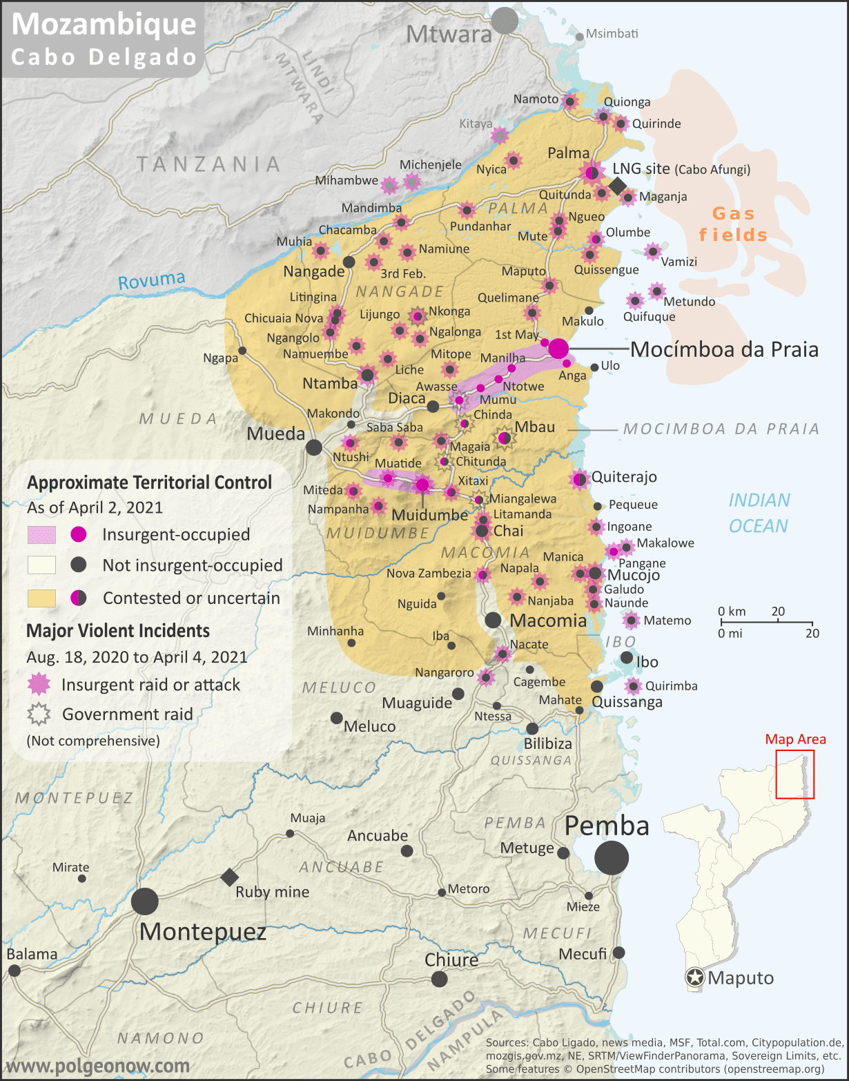
Map by Evan Centanni and Djordje Djukic. Some elements © OpenStreetMap contributors. Terrain data sourced from ViewFinderPanoramas. Contact us for permission to use this map.

(Subscribers click here to view this article in the member area)

Timeline by Djordje Djukic and Evan Centanni

New: Close-up Cabo Delgado Insurgency Map

In the eight months since our first Mozambique conflict timeline was published, insurgents in Cabo Delgado province have gradually increased their control, continuing to raid villages and towns in multiple districts, culminating most recently in their temporary takeover of most of Palma, a major town close to under-construction natural gas facilities operated by French company Total. The rebel group - locally known as "Al Shabaab" but thought to formally label itself Ahlu Sunnah Wa-Jamâ (ASWJ) - is increasingly believed to be cooperating, if only loosely, with the so-called "Islamic State" (IS; ISIS/ISIL).

Now, for the first time, PolGeoNow presents our close-up map of the Cabo Delgado conflict, rigorously researched and edited to provide the most detailed, informative, and reliable map of insurgent control and attacks available anywhere.

Mozambique Insurgency: 2017-2020 Close-up Map & Expanded Timeline (Subscription)

SUBSCRIBERS CLICK HERE TO PROCEED TO ARTICLE AND MAP

There are newer editions of this map available. To see them, view all Mozambique articles on PolGeoNow.

Map and report by Evan Centanni and Djordje Djukic

Subscribe for full access to all conflict map reports!

Mozambique: Cabo Delgado insurgency map - October 2017 to August 2020: Detailed, close-up control map showing areas occupied by so-called ISIS-linked rebels in northern Mozambique (also known as Ahlu Sunnah Wa Jama, ASWJ, or Ansar al-Sunnah), plus towns and villages raided by the insurgents over the past three years. Shows roads, rivers, and terrain, and includes key locations of the insurgency such as Mocímboa da Praia, Awasse, Macomia, the Total LNG site and natural gas fields, Miangalewa, Litingina, Ntessa, Cagembe, Marere, Makulo, and many, many more. Colorblind accessible.
This is an alternate version of our free August 2020 Mozambique control map and report, now featuring a close-up map with much more detail. In addition to territorial control, the map also indicates the locations of other 2017-2020 insurgent attacks and government raids.
 
Included in the accompanying report is a revised and expanded timeline of events since 2017, focusing in on the details of where and when attacks and fighting have happened.

This map and report are premium content, available to paid subscribers of the PolGeoNow Conflict Mapping Service.

Want to see before you subscribe? Check out our most recent FREE SAMPLE Mozambique map!

Exclusive map report includes:

  • Detailed illustration of territorial control in Mozambique's Cabo Delgado province in August 2020, color-coded for insurgents affiliated with the so-called "Islamic State" (ISIS/ISIL) vs. the Mozambican government and allies (including Dyck private military contractors). Areas of contested or unclear control indicated separately. Colorblind accessible. 
  • Detailed indication of city-by-city control status, including for many relevant smaller towns and villages.
  • Detailed indication of which towns and villages were subject to insurgent raids or government attacks from the beginning of armed conflict in October 2017 up to the capture of Mocímboa da Praia town in August 2020.
  • Contextual details like district boundaries, rivers, major roads, and terrain shading.
  • Sites of international economic interest: Total's under-construction LNG plant, offshore natural gas fields, and Montepuez ruby mine.
  • Key locations from the news, including Mocímboa da Praia, Awasse, Macomia, Miangalewa, Litingina, Ntessa, Cagembe, Marere, Makulo, and many, many more.
  • Accompanying article with detailed timeline of territorial control changes and key political and military developments since the outbreak of armed conflict in October 2017, with sources cited. 

SUBSCRIBERS CLICK HERE TO PROCEED TO ARTICLE AND MAP


Not signed up yet? Click here to learn more about our professional subscription service!

Thursday, March 25, 2021

Yemen Control Map & Report - March 2021 (Subscription)

SUBSCRIBERS CLICK HERE TO PROCEED TO ARTICLE AND MAP

There are newer versions of this map available. To see them, view all Yemen articles on PolGeoNow.

Timeline by Djordje Djukic. Map by Evan Centanni, Djordje Djukic, and onestopmap.com

Map of what's happening in Yemen as of March 2021, including territorial control for the unrecognized Houthi government, president-in-exile Hadi and his allies in the Saudi-led coalition, the UAE-backed southern separatist Southern Transitional Council (STC), and Al Qaeda in the Arabian Peninsula (AQAP). Includes recent locations of fighting and other events, including Marib, Al-Sadd Lake, Al Ma'afer, Ahwar, and more.
Subscribe for full access to all conflict map reports!

Forces loyal to Yemen's unrecognized Houthi government have continued their gradual advance towards the central city of Marib. But for the first time in months, they've also faced a major loss of ground elsewhere, with forces loyal to the internationally-recognized President Hadi capturing territory in the southwest.

See all this and more on the newest update to PolGeoNow's Yemen territorial control map, which includes a timeline of changes and important events since our previous Yemen map report in February.

This map and report are premium content available to paid subscribers of the PolGeoNow Conflict Mapping Service.

Want to see before you buy? Check out our most recent FREE SAMPLE Yemen map report!

Exclusive report includes:
  • Up-to-date map of current territorial control in Yemen, color-coded for the pro-Hadi coalition, the separatist Southern Transitional Council (STC), Houthi forces, and Al Qaeda in the Arabian Peninsula (AQAP)
  • Detailed indication of town-by-town control, including provincial boundaries, all major cities, and many smaller ones
  • Markers for recent areas of fighting, including Marib, Al-Sadd Lake, Al Ma'afer, Ahwar, and more
  • Timeline of changes to the situation since February 26, 2021, with links to sources 

SUBSCRIBERS CLICK HERE TO PROCEED TO ARTICLE AND MAP

Not a member yet? Click here to learn more about our professional subscription service!

Can I purchase just this map?
This map and report are not available for automated purchase to non-subscribers. If you need access or republication rights for only this map report, contact service@polgeonow.com for options.

Friday, February 26, 2021

Yemen Control Map & Report: Houthis Approach Marib - February 2021 (Subscription)

SUBSCRIBERS CLICK HERE TO PROCEED TO ARTICLE AND MAP

There are newer versions of this map available. To see them, view all Yemen articles on PolGeoNow.

Timeline by Djordje Djukic. Map by Evan Centanni, Djordje Djukic, and onestopmap.com

Map of what's happening in Yemen as of February 2021, including territorial control for the unrecognized Houthi government, president-in-exile Hadi and his allies in the Saudi-led coalition, the UAE-backed southern separatist Southern Transitional Council (STC), and Al Qaeda in the Arabian Peninsula (AQAP). Includes recent locations of fighting and other events, including Marib, Asdas, Nudhud, and Al-Sadd Lake.
Subscribe for full access to all conflict map reports!

Yemen's two rival national governments - the Houthis and the Hadi administration - appear to be on the verge of a major showdown over Marib, the biggest remaining Hadi stronghold in the north. Meanwhile, large cracks are already showing in the recent unity deal between Hadi and southern separatists, who still maintain separate areas of control.

See all this and more on the newest update to PolGeoNow's Yemen territorial control map, which includes a timeline of changes and important events since our previous Yemen map report in December.

This map and report are premium content available to paid subscribers of the PolGeoNow Conflict Mapping Service.

Want to see before you buy? Check out our most recent FREE SAMPLE Yemen map report!

Exclusive report includes:
  • Up-to-date map of current territorial control in Yemen, color-coded for the pro-Hadi coalition, the separatist Southern Transitional Council (STC), Houthi forces, and Al Qaeda in the Arabian Peninsula (AQAP)
  • Detailed indication of town-by-town control, including provincial boundaries, all major cities, and many smaller ones
  • Markers for recent areas of fighting, including Marib, Asdas, Nudhud, and Al-Sadd Lake
  • Timeline of changes to the situation since December 27, 2020, with links to sources 

SUBSCRIBERS CLICK HERE TO PROCEED TO ARTICLE AND MAP

Not a member yet? Click here to learn more about our professional subscription service!

Can I purchase just this map?
This map and report are not available for automated purchase to non-subscribers. If you need access or republication rights for only this map report, contact service@polgeonow.com for options.

Thursday, February 25, 2021

Somalia Control Map & Timeline - February 2021 (Subscription)

SUBSCRIBERS CLICK HERE TO PROCEED TO ARTICLE AND MAP

There are newer versions of this map available. To see them, view all Somalia articles on PolGeoNow.

Map by onestopmap.com, Evan Centanni, and Djordje Djukic

Subscribe for full access to all conflict map reports!

Who controls Somalia? Map (February 2021). With states, regions, and territorial control. Best Somalia control map online, thoroughly researched, detailed but concise. Shows territorial control by Federal Government of Somalia (FGS), Al Shabaab, so-called Islamic State (ISIS/ISIL), separatist Somaliland, autonomous state Puntland, and boundaries of additional federal member states Galmudug, Jubaland, South West, and Hirshabelle. Now labels state capitals and disputed boundaries between Somaliland and Puntland, as well as key towns from recent news such as Milho (Milxo), Ba'adweyne, Bur Heybe, Gobo Kibir, and more. Updated to February 24, 2021. Colorblind accessible.
In the past four months, control lines have changed little in Somalia's south, but Al Shabaab has increasingly seized villages near the northern coast, in the area disputed between Puntland and Somaliland. Meanwhile, the map has undergone a subtle overhaul, with various small adjustments made after a thorough review of available research.

See all this and more on the latest update to PolGeoNow's concise, professional Somalia control map, which includes a timeline of territorial changes and key events since our previous Somalia map report of October 2020, with sources cited.

This map and report are premium content, available to paid subscribers of the PolGeoNow Conflict Mapping Service.

Want to see before you subscribe? Check out our most recent FREE SAMPLE Somalia map!

Exclusive map report includes:

  • Up-to-date illustration of current territorial control in Somalia, color-coded for the federal government coalition (including AMISOM peacekeepers), autonomous unionist forces, separatist Somaliland, Al Qaeda affiliate Al Shabaab, and fighters aligned with the so-called "Islamic State" (IS; formerly ISIS/ISIL). Areas of mixed or unclear control indicated separately. Colorblind accessible.
  • Boundaries and labels for Somalia's official regions and states, including the self-proclaimed independent Republic of Somaliland and federal states Puntland, Galmudug, Jubaland, South West, and Hirshabelle. Illustrates the claims of both sides in the Somaliland-Puntland border dispute, as well as actual control.
  • Detailed indication of city-by-city control, including many relevant smaller towns and villages.
  • Locations of recent fighting and other important events, including Milho (Milxo), Ba'adweyne, Bur Heybe, Gobo Kibir, and more.
  • Detailed timeline of territorial control changes and key political developments since October 20, 2020, with sources cited. 
  • Summary of the conflict situation and changes to the map over the past four months.

SUBSCRIBERS CLICK HERE TO PROCEED TO ARTICLE AND MAP

Not signed up yet? Click here to learn more about our professional subscription service!