Wednesday, February 3, 2021

Guest Map: Border Changes in Ethiopia's Tigray Conflict (February 2021)

Update: PolGeoNow now has an in-house map showing territorial control in northern Ethiopia. To find the latest version, view all Ethiopia reports.

For the second time, we're honored to feature a map of the Tigray conflict created by our colleague Daniel from Passport Party. Though detailed territorial control is difficult to map right now, Daniel illustrates how the shakeup has resulted in new de facto courses for both state and national borders in the area.

Tigray border changes map: Illustration of changes to the de facto courses of state and national borers amid Ethiopia's Tigray war, as known January 30, 2021, showing areas taken over by Amhara state and Eritrea. By Daniel of Passport Party.
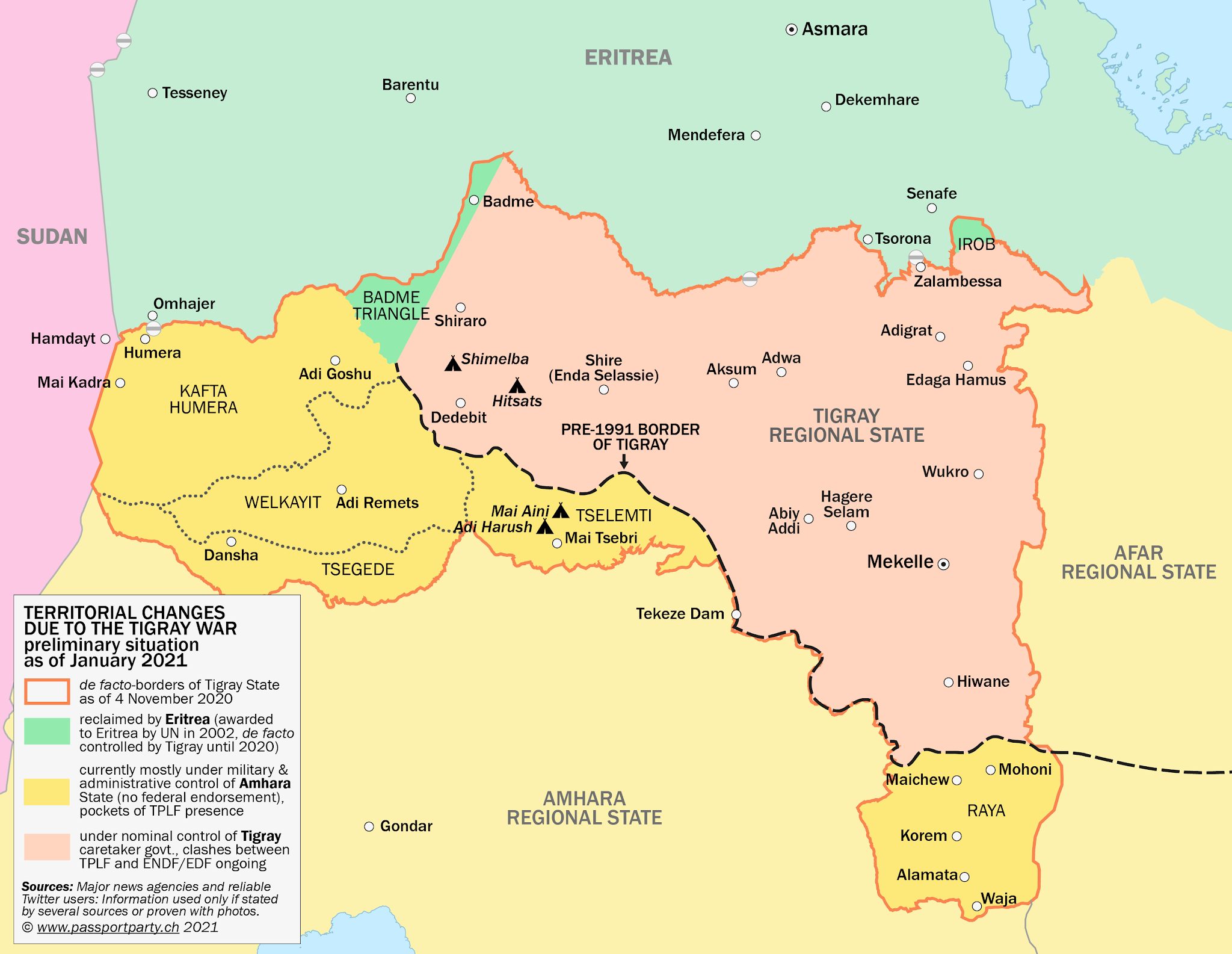
Map of de facto border changes amid the 2020-2021 Tigray conflict, by Daniel of Passport Party (used with permission).


Ethiopia Conflict: Passport Party's Map of Tigray Border Changes 

Since our previous Tigray conflict article in November, featuring our colleague Daniel's map of territorial control at that time, the war in Ethiopia's Tigray state has cooled down somewhat. Because of the situation on the ground, it's probably not possible to reliably map out the details of territorial control in Tigray right now. So instead, Daniel's new map - originally published on his Passport Party blog and Twitter account - focuses on another interesting aspect of the political geography: the way that overall administrative boundaries have changed during the war, even if not officially.
 

Tuesday, February 2, 2021

How Many Countries Were There in the World in 2021?

There are newer editions of this article available. To find the most recent, view all "How Many Countries in the World" updates!

This article, originally from 2011, has been revised and updated to February 2021. You can view some older versions of the article in our archives. Latest update: Removed the so-called "Islamic State" (ISIS/ISIL) as a "de facto state" candidate.

How many countries: map of the world
A world political map published by the US government.
One of the most basic questions for map-lovers is, "How many countries are there in the world?" But anyone who just gives you a number isn't telling the whole truth. It actually depends a lot on how you define a "country".

Here are six of the most common answers, each correct in its own way:

Thursday, January 28, 2021

Nagorno-Karabakh Conflict Map & Report: Aftermath - January 2021 (Subscription)

SUBSCRIBERS CLICK HERE TO PROCEED TO ARTICLE AND MAP

There are newer maps of this conflict available. To see them, view all Nagorno-Karabakh articles on PolGeoNow.

Map by Evan Centanni, Djordje Djukic, Bourrichon, and Lesqual; article by Evan Centanni and Djordje Djukic.

Subscribe for full access to all conflict map reports!

Preview thumbnail of map of territorial change in Nagorno-Karabakh before and after the 2020 war between Azerbaijan and the Armenia-backed, self-proclaimed Republic of Artsakh. Updated to January 28, 2020, to highlight locations of important events taking place in the aftermath of the peace deal's implementation. Colorblind accessible.
Though our map has barely changed since forces of Armenia and the self-proclaimed Republic of Artsakh completed their promised handovers of land to Azerbaijan two months ago, territory remains a major issue in the region. 
 
This subscriber-exclusive report goes in-depth on territorial issues and conflict-related developments since our previous Nagorno-Karabakh map and timeline at the beginning of December, with key sites of contention newly marked on this edition of the map.

This map and report are premium content, available to paid subscribers of the PolGeoNow Conflict Mapping Service.

Want to see before you subscribe? Check out our most recent FREE SAMPLE Nagorno-Karabakh map!

Exclusive map report includes:

  • Up-to-date illustration of current territorial control in Azerbaijan, Armenia, and the disputed Nagorno-Karabakh region, including the self-proclaimed Republic of Artsakh, showing the differences between the situation before the war versus now. Colorblind accessible. 
  • Claimed borders of the Republic of Artsakh, as well as the former extent of the Soviet-era Nagorno-Karabakh Autonomous Oblast (NKAO).
  • Key locations of conflict and contention since the completion of Armenian withdrawals, including Khtsaberd, Shurnukh, Kapan, the Sotk gold mine, and more.
  • Detailed timeline of territorial contention and conflict events since Dec. 1, 2020, as well as key military/political developments, with sources cited. 

SUBSCRIBERS CLICK HERE TO PROCEED TO ARTICLE AND MAP

Not signed up yet? Click here to learn more about our professional subscription service!

Friday, January 22, 2021

US State of Mississippi Adopts New Flag

The new official flag of the US state of Mississippi, approved in a popular referendum on November 3, 2020 and formally adopted January 11, 2021. Features a white magnolia flower on a dark blue background, surrounded by 20 white stars topped with a golden star-like symbol. The left and right sides of the flag are red, separated from the blue center by thin golden borders.
Mississippi's new flag, officially adopted January 11, 2021 (public domain graphic).

50 State Flags Again

For the first time since last June, every one of the US's 50 states has its own flag. Last year, Mississippi became the only flagless state after its government voted to withdraw its former banner, controversial for incorporating the battle emblem of 19th Century pro-slavery separatists.

USA: Rhode Island State's Name Change

Map of the State of Rhode Island - formerly the State of Rhode Island and Providence Plantations - from the United States National Atlas
State of Rhode Island and Providence Plantations. The island hosting Newport (lower right) is the original "Rhode Island", while "Providence Plantations" referred to the mainland area around Providence (top right). (Public domain map)

Rhode Island Name Change Now in Effect

Tiny Rhode Island has become the first of the 50 US states ever to change its name.

Even many Americans don't realize that Rhode Island, the smallest US state by area, actually had a longer official name until last year: State of Rhode Island and Providence Plantations. 

But in a referendum on Nov. 3, the same day as the 2020 US presidential election, the state's voters chose to amend the state constitution and shorten the name to just "State of Rhode Island".