Friday, August 25, 2017

Somalia Control Map & Timeline - August 2017

This is the first in our new series of Somalia control maps, which includes regular updates for members of our conflict map subscription service

There are newer versions of this map available. To see them, view all Somalia articles on PolGeoNow.

Who controls Somalia? Map (2017). With states, regions, and territorial control. Best Somalia control map online, thoroughly researched and detailed but concise. Shows territorial control by Federal Government of Somalia (FGS), Al Shabaab, so-called Islamic State (ISIS/ISIL), separatist Somaliland, and autonomous states Puntland, Galmudug, Khatumo, and the ASWJ Sufi militia. Updated to of August 25, 2017. Colorblind accessible.
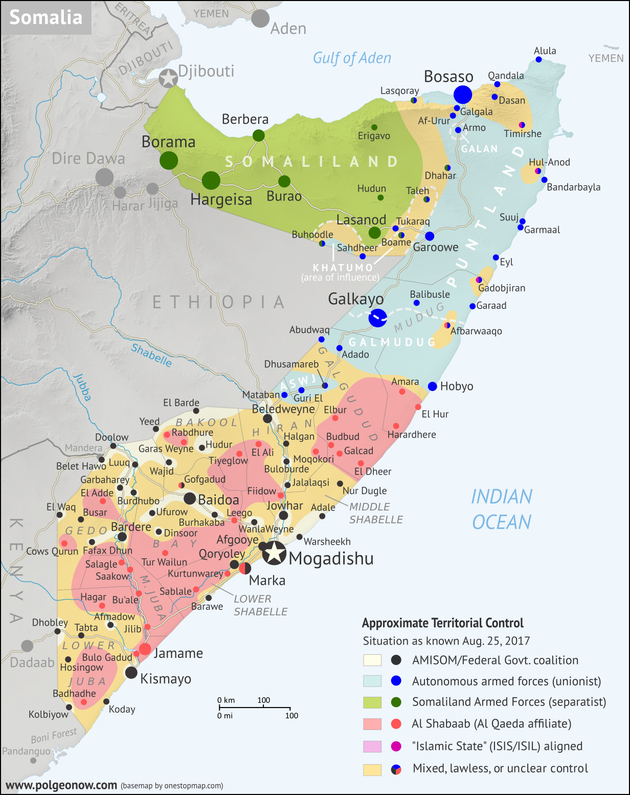
Base map by Koen Adams of onestopmap.com, with territorial control by Djordje Djukic and Evan Centanni. (This graphic has been slightly revised based on newer information. You can see the original version here.)
Contact us for permission to use this map.
(Subscribers click here to view this article in the member area)

Timeline by Djordje Djukic, with additional reporting by Evan Centanni

Mapping Somalia: Who Controls What?

Of all the world's countries, Somalia is probably the most complex in terms of actual territorial control, and also one of the most constantly-changing. Despite that, good control maps for Somalia are hard to find, with major news outlets using simple, hastily-drawn maps (if any), while crowdsourced mapping projects on sites like Wikipedia suffer from a lack of contributors, infrequent updates, and unclear methods. That's why Political Geography Now set out to create the best-designed, most thoroughly-researched Somalia control map online.

Tuesday, August 22, 2017

Yemen Control Map & Report: August 2017 (Subscription)

SUBSCRIBERS CLICK HERE TO PROCEED TO ARTICLE AND MAP

Map of what is happening in Yemen as of May 21, 2017, including territorial control for the unrecognized Houthi government and former president Saleh's forces, president-in-exile Hadi and his allies in the Saudi-led coalition and Southern Movement, Al Qaeda in the Arabian Peninsula (AQAP), and the so-called Islamic State (ISIS/ISIL). Includes recent locations of fighting, including Azzan, Habban, Maydee, Nihm, and more.
Subscribe for full access to all conflict map reports!

Timeline by Djordje Djukic. Map by Louis Martin-Vézian, Evan Centanni, and Djordje Djukic.

In the past three months, fighting in Yemen has continued, with small changes of territorial control along the front lines between Yemen's two rival governments. Meanwhile, a US-assisted campaign against Al Qaeda in the Arabian Peninsula (AQAP) has removed some of the group's last remaining towns from its control.


See all this and more on the newest update to PolGeoNow's Yemen territorial control map, which includes a timeline of changes and important events since our previous Yemen map report in late February.

This map and report are premium professional content, available to paid subscribers of the PolGeoNow Conflict Mapping Service.

Want to see before you buy? Check out our most recent FREE SAMPLE Yemen map report!

Exclusive report includes:
  • Up-to-date map of current territorial control in Yemen, color-coded for the pro-Hadi coalition, Houthi/Saleh forces, Al Qaeda in the Arabian Peninsula (AQAP), and the so-called "Islamic State" (ISIS/ISIL).
  • Detailed indication of town-by-town control, including provincial boundaries, all major cities, and many smaller ones
  • Markers for recent areas of fighting, including Azzan, Habban, Maydee, Nihm, and more
  • Timeline of changes to the situation since May 18, 2017, with links to sources

SUBSCRIBERS CLICK HERE TO PROCEED TO ARTICLE AND MAP

Not a member yet? Click here to learn more about our professional subscription service!

Can I purchase just this map?
This map and report are not available for automated purchase to non-subscribers. If you need access or republication rights for only this map report, contact service@polgeonow.com for options.

Tuesday, August 1, 2017

Map: Which Schengen Borders are Closed to Passport-Free Travel in August 2017?

There are newer versions of this map available. To see them, view all Schengen Area articles.

Last year, we explained Europe's Schengen free travel area in plain English, then published maps of which European countries had temporarily reintroduced border controls as of March 2016, August 2016, and February 2017. Here's an update and summary for August of 2017.

Schengen borders map showing temporary reintroduction of border controls in the Schengen Area (the European Union's border-free travel zone) as of August 2017, showing internal Schengen borders closed to passport-free travel in the period after the election of French President Emmanual Macron.
Map by Evan Centanni, from blank map by Ssolbergj. License: CC BY-SA
Article by Evan Centanni

Current Border Controls Between Schengen Countries

As anyone who's visited Europe in recent decades knows, much of the continent is linked together as part of the "Schengen Area", a collection of countries that don't make travelers show any ID to cross back and forth across their borders (though this system is overseen by the European Union, the Schengen Area and the EU aren't the same thing). But the system does allow countries to temporarily reintroduce border controls under certain circumstances.

Monday, July 31, 2017

Iraq Control Map & Timeline: "Islamic State" Loses Mosul - July 2017 (Subscription)

SUBSCRIBERS CLICK HERE TO PROCEED TO ARTICLE AND MAP

There are newer versions of this map available. To see them, view all Iraq updates.

Research by Djordje Djukic. Map by onestopmap.com, Evan Centanni, and Djordje Djukic

Subscribe for full access to all conflict map reports!

Detailed map of territorial control in Iraq as of July 30, 2017 after the end of the Battle of Mosul, including territory held by the so-called Islamic State (ISIS, ISIL), the Baghdad government, the Kurdistan Peshmerga, and the Yezidi Sinjar Alliance (YBS and YJE). Colorblind accessible.
In the past month, Iraqi government forces and allies have completed their recapture of Mosul, the third biggest city in Iraq and the largest urban center ever controlled by the so-called "Islamic State" (IS; formerly ISIS/ISIL) in any country.

See all this and more on the latest update to PolGeoNow's concise, professional map of control in Iraq's civil war, including a timeline of changes since our previous Iraq map report of June 2017.

This map and report are premium professional content, available to paid subscribers of the PolGeoNow Conflict Mapping Service.

Want to see before you subscribe? Check out our most recent FREE SAMPLE Iraq map report!

Exclusive report includes:
  • Up-to-date map of current territorial control in Iraq, color-coded for the Iraqi government, "Islamic State" (ISIS/ISIL) fighters, and Kurdistan's Peshmerga forces. Colorblind accessible.
  • New: Separate color for Yezidi militias of the "Sinjar Alliance", who control their own territory near the Syrian border.
  • Detailed indication of town-by-town control, including all major cities and many smaller ones, as well as terrain, major roads, and provincial boundaries
  • Timeline of changes to the situation since mid-June, compiled by our Iraq-Syria specialist, with links to sources
SUBSCRIBERS CLICK HERE TO PROCEED TO ARTICLE AND MAP

Not signed up yet? Click here to learn more about our professional subscription service!

Can I purchase just this map?
This map and report are not available for automated purchase to non-subscribers. If you need access or republication rights for only this map report, contact service@polgeonow.com for options.

Friday, July 21, 2017

Syrian Civil War Map & Timeline: "Islamic State" Capital Surrounded - July 2017 (Subscription)

SUBSCRIBERS CLICK HERE TO PROCEED TO ARTICLE AND MAP

There are newer versions of this map available. To see them, view all Syria updates.

Research by Djordje Djukic. Map by onestopmap.com, Evan Centanni, and Djordje Djukic

Subscribe for full access to all conflict map reports!

Map of Syrian Civil War (Syria control map): Fighting and territorial control in Syria in July 2017 (Free Syrian Army rebels, Kurdish YPG, Syrian Democratic Forces (SDF), Jabhat Fateh al-Sham / Hayat Tahrir al-Sham (Al-Nusra Front), Islamic State (ISIS/ISIL), and others). Includes Russia-Turkey-Iran agreed de-escalation zones and US deconfliction zone, plus recent locations of conflict and territorial control changes, such as Raqqah, Resafa, Ithriya, al-Hamima, Qasr, and more. Colorblind accessible. In the past month, the so-called "Islamic State" (ISIS/ISIL) has continued losing ground, with its capital city of Raqqah now completely surrounded by US-backed fighters. Meanwhile, southern Syria has seen rebel defeats at the hands of government forces, but also a ceasefire backed by both the US and Russia.

See all this and more on the latest update to PolGeoNow's concise, professional Syrian Civil War control map, which includes a timeline of changes since our previous Syria map report in June, with sources cited.

This map and report are premium content, available to paid subscribers of the PolGeoNow Conflict Mapping Service.

Want to see before you subscribe? Check out our most recent FREE SAMPLE Syria map!

Exclusive map report includes:
  • Up-to-date illustration of current territorial control in Syria, color-coded for the Assad government, rebel groups, "Islamic State" (ISIS/ISIL) fighters, and Kurdish/SDF forces. Colorblind accessible.
  • Markers showing the approximate locations of Russian-Turkish-Iranian "de-escalation zones" and the one known US "deconfliction zone".
  • Special symbols indicating towns dominated by rebels of the former Nusra Front (now Hayat Tahrir al-Sham) and US-backed Syrian Democratic Forces (SDF).
  • Detailed indication of city-by-city control, including key towns and other locations important to current events.
  • Locations of recent fighting and other important events, including Raqqah, Resafa, Ithriya, al-Hamima, Qasr, and more.
  • Detailed timeline of important events and changes to territorial control since June 21, 2017, compiled by our Syria-Iraq expert, with links to sources.

SUBSCRIBERS CLICK HERE TO PROCEED TO ARTICLE AND MAP

Not signed up yet? Click here to learn more about our professional subscription service!

Can I purchase just this map?
This map and report are not available for automated purchase to non-subscribers. If you need access or republication rights for only this map report, contact service@polgeonow.com for options.