Monday, September 14, 2015

Syrian Civil War Control Map: September 2015 (Subscription)

There are newer versions of this map available. To see them, view all Syria updates.

Map of fighting and territorial control in Syria's Civil War (Free Syrian Army rebels, Kurdish YPG, Al-Nusra Front, Islamic State (ISIS/ISIL), and others), updated for September 2015. Highlights recent locations of conflict and territorial control changes, such as Abu Duhur airbase, Qadam district, Mansoura, Marea, and more.
Subscribe for full access to all conflict map reports!

Download PDF:
Buy now
Research by Djordje Djukic, with additional reporting by Evan Centanni

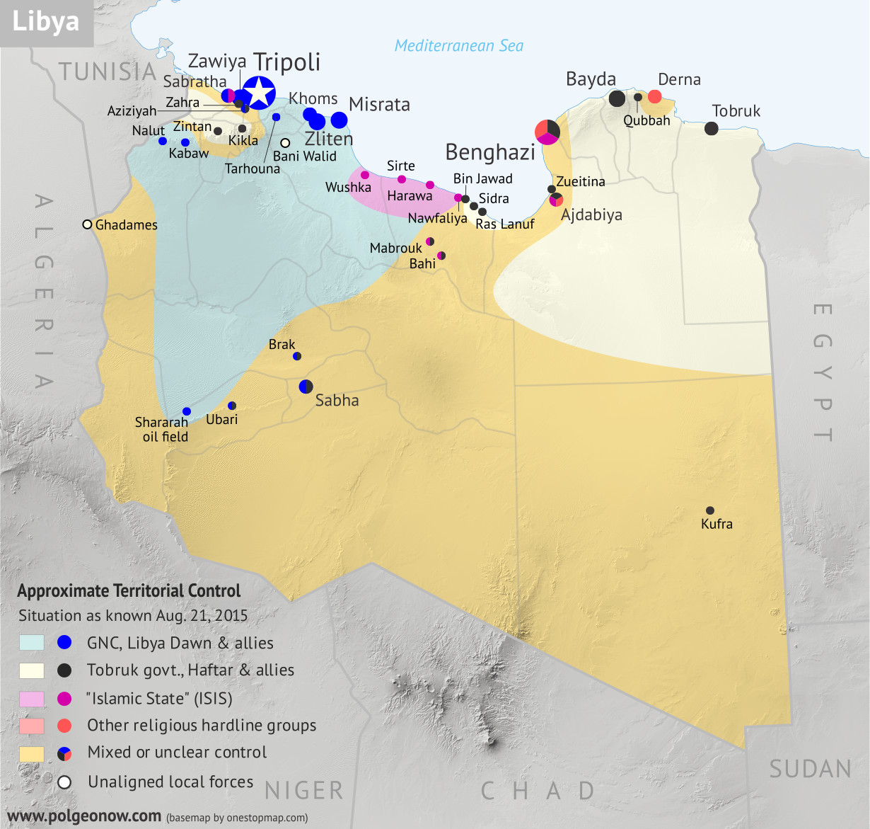
Anti-government rebels in Syria, including fighters from the Al Qaeda-affiliated Nusra Front, have further consolidated their control of Idlib province in the country's northwest. Meanwhile, forces of the "Islamic State" are again occupying parts of the capital city, Damascus, even as they besiege several other locations in Syria.

See all this and more on the newest update to PolGeoNow's concise, professional-quality Syrian Civil War control map, which includes a timeline of changes since our previous Syria map report last month.

This map and report are professional subscriber content, available to paid members or for separate purchase. Download PDF (US$19.99)

Want to see before you buy? Check out our most recent FREE SAMPLE Syria map!

Exclusive map report includes:
  • Up-to-date map of current territorial control in Syria, color-coded for the Assad government, rebel groups, "Islamic State" (ISIS/ISIL) extremists, and Kurdish YPG forces. Special symbol indicates rebel-held towns dominated by Al Qaeda affiliate Jabhat al-Nusra (the Nusra Front).
  • Detailed indication of city-by-city control, highlighting key towns and other locations important to current events.
  • Locations of recent fighting and military operations, including Abu Duhur airbase, Marea, Qadam district, Mansoura, and more.
  • Detailed timeline of important events and changes to territorial control since August 20, 2015, compiled by our Syria-Iraq expert, with links to sources.

MEMBERS CLICK HERE TO PROCEED TO ARTICLE AND MAP

Not a member yet? Click here to learn more about our professional subscription service!


Saturday, August 22, 2015

War in Libya: Map of Control in August 2015

There are newer versions of this map available. To see them, view all Libya updates.

This is the first of a series of professional Libya control maps. Secure your access to future updates: sign up now for our conflict map subscription service!

Libya control relief map: Shows detailed territorial control in Libya's civil war as of August 2015, including all major parties (Tobruk government, General Haftar's Operation Dignity forces, and Zintan militias; Tripoli GNC government, Libya Dawn, and Libya Shield Force; Shura Council of Benghazi Revolutionaries and other hardline Islamist groups; and the so-called Islamic State). Also file under: Map of Islamic State (ISIS) control in Libya.
Base map by Koen Adams of onestopmap.com, with territorial control by Evan Centanni. All rights reserved.

Subscribers click here to view this article in the ad-free members area. Not a member yet? Subscribe now! 

Background summary by Djordje Djukic; timeline by Evan Centanni and T.H.

Included in this free article:
  • Concise summary of events in Libya since the fall of Muammar Gaddafi in 2011
  • Detailed timeline of conflict, changes to territorial control, and political events since 2011, with each mentioned location illustrated on the map above

Friday, August 21, 2015

Syrian Civil War Control Map: August 2015 (Subscription)

There are newer versions of this map available. To see them, view all Syria updates.

Map of fighting and territorial control in Syria's Civil War (Free Syrian Army rebels, Kurdish YPG, Al-Nusra Front, Islamic State (ISIS/ISIL), and others), updated for August 2015. Highlights recent locations of conflict and territorial control changes, such as Ayn Issa, Sarrin, Hasakah, Mansour, Frikka, Elbeyli, Qaryatain, and more.

Download PDF:
Buy now


(Subscribe via Paypal to view all premium content online)
Research by Djordje Djukic, with additional reporting by Evan Centanni

Since the end of June, the borders of the so-called "Islamic State" (IS) have changed significantly in Syria, with Kurdish advances from the north and IS pushes into the country's west. Meanwhile, rebels continue to struggle with the Assad government for dominance over the country's remaining territory.

See all this and more on the newest update to PolGeoNow's professional Syrian Civil War control map, which includes a timeline of changes since our previous Syria map report at the end of June.

This map and report are professional subscriber content, available to paid members or for separate purchase. Download PDF (US$19.99)

Want to see before you buy? Check out our most recent FREE SAMPLE Syria map!

Exclusive map report includes:
  • Up-to-date map of current territorial control in Syria, color-coded for the Assad government, rebel groups, "Islamic State" (ISIS/ISIL) extremists, and Kurdish YPG forces. Special symbol indicates rebel-held towns dominated by Al Qaeda affiliate Jabhat al-Nusra (the Nusra Front).
  • Detailed indication of city-by-city control, highlighting key towns and other locations relevant to current events.
  • Locations of recent fighting and military operations, including Ayn Issa, Sarrin, Hasakah, Mansour, Frikka, Elbeyli, Qaryatain, and others
  • Detailed timeline of important events and changes to territorial control since June 29, 2015, compiled by our Syria-Iraq expert, with links to sources.

MEMBERS CLICK HERE TO PROCEED TO ARTICLE AND MAP

Not a member yet? Click here to learn more about our professional subscription service!


Friday, August 14, 2015

Yemen's Civil War: Map of Control in August 2015 (Subscription)

There are newer versions of this map available. To see them, view all Yemen updates.

Map of territorial control in Yemen as of August 14, 2015, during Saudi Arabia's military intervention, including territory held by the Houthi rebels and former president Saleh's forces, president-in-exile Hadi and the Southern Movement, and Al Qaeda in the Arabian Peninsula (AQAP). Includes recent areas of fighting, such as Houta, Al-Anad Airbase, Dhale, Ibb, Ataq, and more.

Download PDF:
Buy now


(Subscribe via Paypal to view all premium content online)
Timeline by Djordje Djukic, with additional reporting by Evan Centanni; map by Louis Martin-Vézian and Evan Centanni

Yemen's Houthi revolutionary government, despite support from Iran, is rapidly losing ground against the fighters aligned to President Hadi, and supporting forces from Saudi Arabia and the United Arab Emirates. 

A long list of towns have changed hands just within the last two weeks, and Al Qaeda is on the move as well. See all this and more on the newest update to PolGeoNow's Yemen territorial control map, which includes a timeline of changes since our previous Yemen map report in July.

This map and report are exclusive premium content, available to paid subscribers or for individual purchase.
Download PDF (US$14.99)

Want to see before you buy? Check out our most recent FREE SAMPLE Yemen map report!

Exclusive map report includes:
  • Up-to-date map of current territorial control in Yemen, color-coded for the Hadi coalition, Houthi/Saleh forces, and Al Qaeda in the Arabian Peninsula (AQAP).
  • Detailed indication of town-by-town control, including provincial boundaries, all major cities, and many smaller ones
  • Markers for key areas of recent fighting such as Houta, Al-Anad Airbase, Utmah, Ibb, Rabat, Lawdar, Bayda, Ataq, and more
  • Timeline of changes to the situation since the end of July, with links to sources

MEMBERS CLICK HERE TO PROCEED TO ARTICLE AND MAP

NOT A MEMBER YET? SUBSCRIBE NOW!

Friday, August 7, 2015

New Olympic Nation: South Sudan (Map)

Paid subscribers click here to view this article in the ad-free members area. Not a member yet? Subscribe now!


World map showing the five continental associations of National Olympic Committees. Shows all Olympic nations, and labels the two newest as of August 2015, Kosovo and South Sudan.
Map of all nations in the Olympics, and their regional associations. Two newest Olympic nations labeled.
Map by Evan Centanni, starting from this blank map and modeled after this map.

Thursday, July 30, 2015

Yemen's Civil War: Map of Control in July 2015 (Subscription)

There are newer versions of this map available. To see them, view all Yemen updates.

Map of territorial control in Yemen as of July 29, 2015, during Saudi Arabia's military intervention, including territory held by the Houthi rebels and former president Saleh's forces, president-in-exile Hadi and the Southern Movement, and Al Qaeda in the Arabian Peninsula (AQAP). Includes recent areas of fighting, such as Aden, Sabr, Al-Anad Airbase, Wadiah crossing, Marib, and more.

Download PDF:
Buy now


(Subscribe via Paypal to view all premium content online)
Timeline by Djordje Djukic, with additional reporting by Evan Centanni; map by Louis Martin-Vézian and Evan Centanni

In the past month, Yemen's Saudi-backed resistance forces have finally begun making inroads against the Houthis, capturing a major southern city while also extending their control to the northern border with Saudi Arabia.

See all this and more on the newest update to PolGeoNow's Yemen territorial control map, which includes a timeline of changes since our previous Yemen map report in June.

This map and report are exclusive premium content, available to paid subscribers or for individual purchase.
Download PDF (US$14.99)

Want to see before you buy? Check out our most recent FREE SAMPLE Yemen map report!

Exclusive map report includes:
  • Up-to-date map of current territorial control in Yemen, color-coded for the Hadi government, Houthi/Saleh forces, and Al Qaeda in the Arabian Peninsula (AQAP).
  • Detailed indication of town-by-town control, including provincial boundaries, all major cities, and many smaller ones
  • Markers for key areas of recent fighting such as Aden, Al-Anad, Sabr, Marib, Wadiah border crossing, and more
  • Timeline of changes to the situation since July, compiled by our Yemen specialist, with links to sources

MEMBERS CLICK HERE TO PROCEED TO ARTICLE AND MAP

NOT A MEMBER YET? SUBSCRIBE NOW!

Friday, July 24, 2015

War in Iraq: Map of "Islamic State" Control in July 2015 (Subscription)

There are newer versions of this map available. To see them, view all Iraq updates.

Detailed map of territorial control in Iraq as of July 23, 2015, including territory held by the so-called Islamic State (ISIS, ISIL), the Baghdad government, and the Kurdistan peshmerga. Includes recent flashpoints including Ramadi, Baiji, Habaniyah, Jalawla, and Walid border crossing.

Download PDF:
Buy now


(Subscribe via Paypal to view all premium content online)
Timeline by Djordje Djukic; map and additional reporting by Evan Centanni

Since May, fighting in Iraq has seen small but potentially important advances by all sides, including the Baghdad government (with Iranian support), the "Islamic State" extremists, and Kurdistan's peshmerga.

See all this and more on the newest update to PolGeoNow's Iraq territorial control map, which includes a timeline of changes since our previous Iraq map report in May.

This map and report are exclusive premium content, available to paid subscribers or for separate purchase.
Download PDF (US$14.99)

Want to see before you buy? Check out our most recent FREE SAMPLE Iraq map report!

Exclusive map report includes:
  • Up-to-date map of current territorial control in Iraq, color-coded for the Iraqi government, "Islamic State" (ISIS/ISIL) extremists, and Kurdish peshmerga forces
  • Detailed indication of town-by-town control, including provincial boundaries, all major cities, and many smaller ones
  • Markers for key areas of recent fighting such as Baiji, Ramadi, Husaybah, Walid border crossing, and more
  • Timeline of changes to the situation since May, compiled by our Iraq specialist, with links to sources

MEMBERS CLICK HERE TO PROCEED TO ARTICLE AND MAP

NOT A MEMBER YET? SUBSCRIBE NOW!

Thursday, July 16, 2015

Paraguay's Subtle Flag Change

Sometimes geopolitical changes make headlines, but other times they slip quietly under the radar. In particular, small modifications to national flags often fail to make the news. To make sure you don't miss anything, here's a report on one such flag change that even we discovered only recently.

Premium members click here to view this article in the ad-free members area. Not a member yet? Subscribe now!

Flag of Paraguay, obverse (front) side, 2013-present
Flag of Paraguay, 2013-present (front)

Flag of Paraguay, reverse (back) side, 2013-present
Flag of Paraguay, 2013-present (back)

Changes to the Coat of Arms of Paraguay made in 2013, with a comparison of the National Seal and Seal of the Treasury as seen on the Paraguayan flag before and after its changes under the administration of President Federico Franco.
The Coat of Arms of Paraguay
(CC BY-SA; source graphics)
By Olga Rodriguez-Walmisley

2013 Flag Change
On July 15, 2013, Federico Franco, at that time the President of Paraguay, announced that the official seals on both sides of the Paraguayan flag would undergo changes in order to better represent the symbols first chosen for it in 1842. These two seals together make up the national coat of arms of Paraguay.

Franco said the modifications were the result of a long debate and “a consensus that is not often achieved among historians”. There had already been several changes to the seals in the past, especially after the Paraguayan War of 1864-1870, which pitted the country against Brazil, Argentina, and Uruguay.

Changes made to the National Seal
One of the biggest of the 2013 changes was to the ring around the star, where it says “República del Paraguay”. This ring has been red since about 1988, when it was changed under the rule dictator Alfredo Stroessner, whose political party was represented by that color. It is now white. The blue background behind the yellow star has also disappeared, and the text of the phrase “República del Paraguay” has changed from yellow to black.

Changes made to the Seal of the Treasury
On the reverse side of the flag, the roaring lion is now a light ochre (golden) color instead of yellow, the spear behind the lion is brown, while the cap on top of the spear, which according to tradition symbolizes liberty, continues to be red. The inscription “Paz y Justicia” (Peace and Justice) is now black instead of yellow, and the banner behind the inscription has gone from red to white.

Tuesday, June 30, 2015

Syrian Civil War Control Map: June 2015 (Subscription)

There are newer versions of this map available. To see them, view all Syria updates.

Map of fighting and territorial control in Syria's Civil War (Free Syrian Army rebels, Kurdish groups, Al-Nusra Front, Islamic State (ISIS/ISIL), and others), updated for late June 2015. Highlights recent locations of conflict and territorial control changes, such as Palmyra, Ariha, Tel Abyad, Ayn Issa, and Hasakah, Kobani, and Suwayda.

Download PDF:
Buy now


(Subscribe via Paypal to view all premium content online)
Research by T.H., with additional reporting by Evan Centanni

Since late May, rebels have consolidated their power in Syria's northwest, Kurdish forces have extended their control across most of the border with Turkey, and the Islamic State continues advancing in the direction of Damascus.

See all this and more on the newest update to PolGeoNow's popular Syria control map, which includes a timeline of changes since our previous Syria map report in May.

This map and report are exclusive premium content, available to paid subscribers or for separate purchase.
Download PDF (US$19.99)

Exclusive map report includes:
  • Up-to-date map of current territorial control in Syria, color-coded for the Assad government, rebel groups, Islamic State (ISIS/ISIL) extremists, and Kurdish YPG forces. Special symbol indicates rebel-held towns dominated by Al Qaeda affiliate Jabhat al-Nusra.
  • Detailed indication of city-by-city control, highlighting key towns and other locations relevant to current events.
  • Locations of recent fighting and military operations, including Tel Abyad, Ayn Issa, Hasakah, Kobani, Palmyra, Ariha, Suwayda, and more.
  • Timeline of important events and changes to territorial control since May 24, 2015, with links to sources.

MEMBERS CLICK HERE TO PROCEED TO ARTICLE AND MAP

NOT A MEMBER YET? SUBSCRIBE NOW!


Tuesday, June 23, 2015

Yemen's Civil War: Map of Control in June 2015

There are newer versions of this map available. To see them, view all Yemen updates.

This is part of a series of Yemen maps and infographics created in collaboration between PolGeoNow and CIGeography. Part 1 was the Map & Infographic of Foreign Military Deployments in Yemen, and Part 2 was War in Yemen: Map of Territorial Control (April 2015).

Map of territorial control in Yemen as of June 22, 2015, about two months into Saudi Arabia's military intervention, including territory held by the Houthi rebels and former president Saleh's forces, president-in-exile Hadi and the Southern Movement, and Al Qaeda in the Arabian Peninsula (AQAP).
Map by Louis Martin-Vézian and Evan Centanni (click to enlarge). All rights reserved.
Subscribers click here to view this article in the ad-free members area. Not a member yet? Subscribe now!

Timeline by Djordje Djukic, with additional reporting by Evan Centanni

Houthi Control Spreading Despite Saudi Airstrikes
Since our previous Yemen control map update in early April, Saudi Arabia and its coalition partners have continued their air and sea campaign in support of the ousted Yemeni government of President Abd Rabbuh Mansur Hadi, supported by parts of the Yemeni military and allied local and southern forces. But two months into the intervention, their opponents, the northern Houthi rebels and forces loyal to former president Ali Abdullah Saleh, have continued to expand eastward. Meanwhile, Al Qaeda fighters have consolidated their control in parts of eastern Yemen, and the port city of Aden is still divided by frequent battles.

Wednesday, June 10, 2015

Map of Rebel Control in Mali: June 2015

(To see other maps in this series, view all Mali articles.)

Map of territorial control in Mali as of June 2015. Includes separatist rebel control (CMA, MNLA, MAA, HCUA) and locations of UN peacekeeper (MINUSMA) deployments, as well as the location of a brief takeover by Al Qaeda in the Islamic Maghreb (AQIM).
Map by Evan Centanni, modified from this map by Orionist, Carport, and NordNordWest. License: CC BY-SA.
Subscribers click here to view this article in the ad-free members area. Not a member yet? Subscribe now!

Article by Evan Centanni

Separatist Return to Power
At the time of our last Mali rebel control map report, separatist rebels had just allowed the Malian government to resume control of the north as part of a ceasefire agreement ahead of elections. The rebels had for a time resumed control of the region after a French-led military intervention pushed out the religiously-oriented rebel groups who had usurped the initial separatist rebellion. In July 2013, Mali's territory was again united for the first time in over a year.

Friday, June 5, 2015

Vatican City Administration Recognizes Palestine as a Country (map)

(Keep up with changes to Palestine's situation: view all Palestine updates.)

Map of countries that recognize the State of Palestine as an independent country, updated for June 2015 with recent addition Vatican City (Holy See) highlighted
Click to enlarge: Countries recognizing the State of Palestine in green, with most recent addition highlighted. Palestine in magenta (circled). Map by Evan Centanni, modified from public domain graphic (source).
Subscribers click here to view this article in the ad-free members area. Not a member yet? Subscribe now!

Thursday, May 28, 2015

Map of Boko Haram Control in Nigeria: May 2015 (Subscription)

The best online map of Boko Haram's territorial control - guaranteed! 

There are newer versions of this map available. To see them, view all Boko Haram updates.

Detailed map of Boko Haram's territorial control in its war with Nigeria, marking each town reportedly under the group's control in Borno, Yobe, and Adamawa states. Includes key recent locations, such as Gwoza, Marte, and the Sambisa Forest.

Download PDF:
Buy now


(Subscribe via Paypal to view all premium content online)
Timeline by T.H., with additional reporting by Evan Centanni

Even as evidence mounts of Boko Haram's ties to the Islamic State, the Nigerian rebel group has been driven from most of its recently-held territory. Yet as Nigeria's new president prepares to take office, Boko Haram may already be making a comeback.

This map report illustrates areas of known and possible Boko Haram control in Nigeria, and for the first time shows the full area of the Sambisa Forest, the rebels' last-resort hideout. The report includes a summary and timeline of events since our previous Boko Haram control map in March.

This map report is exclusive premium content, available to paid subscribers or for separate purchase. Buy now (US$14.99)

Exclusive map report includes:
  • Map of Boko Haram's overall area of control in Nigeria, updated to May 28, 2015.
  • Detailed mapping of each town under Boko Haram's influence, as well as most locations of recent attacks.
  • New: Full outline of the Sambisa Forest, Boko Haram's vast safe haven.
  • Summary and detailed timeline of territorial changes and major events since late March, with links to sources.

MEMBERS CLICK HERE TO PROCEED TO ARTICLE AND MAP

NOT A MEMBER YET? SUBSCRIBE NOW!


Tuesday, May 26, 2015

Syria Civil War Control Map: May 2015 (Subscription)

There are newer versions of this map available. To see them, view all Syria updates.

Map of fighting and territorial control in Syria's Civil War (Free Syrian Army rebels, Kurdish groups, Al-Nusra Front, Islamic State (ISIS/ISIL) and others), updated for late May 2015. Highlights recent locations of conflict and territorial control changes, such as Palmyra, Jisr al-Shughur, al-Janf border crossing, and others.

Download PDF:
Buy now


(Subscribe via Paypal to view all premium content online)
Research by T.H., with additional reporting by Evan Centanni

Since just last month, the Syrian government of Bashar al-Assad has lost important ground to both the rebel coalition (including Al Qaeda affiliate Jabhat al-Nusra) and the Islamic State. The war has also spread into new parts of Syria previously untouched by fighting, while Kurdish groups in the north are continuing to consolidate their gains.

See all this and more on the newest update to PolGeoNow's popular Syria control map, and read a timeline of changes since our previous Syria map report in mid-April.

This map and report are exclusive premium content, available to paid subscribers or for separate purchase.
Download PDF (US$19.99)

Exclusive map report includes:
  • Up-to-date map of current territorial control in Syria, color-coded for the Assad government, rebel groups, Islamic State (ISIS/ISIL) extremists, and Kurdish self-protection forces. Special symbol indicates rebel-held towns dominated by Al Qaeda affiliate Jabhat al-Nusra.
  • Detailed indication of city-by-city control, highlighting key towns and other locations relevant to current events.
  • Locations of recent fighting and military operations, including Palmyra, Jisr al-Shughur, Yarmouk, al-Tanf border crossing, and more.
  • Timeline of important events and changes to territorial control since April 10, 2015.

MEMBERS CLICK HERE TO PROCEED TO ARTICLE AND MAP

NOT A MEMBER YET? SUBSCRIBE NOW!


Friday, May 22, 2015

War in Iraq: Map of Islamic State Control in May 2015

There are newer versions of this map available. To see them, view all Iraq updates.

This is a free sample of our Iraq territorial control map. To access more Iraq control map updates like this one, sign up now for our conflict map subscription service!

Detailed map of territorial control in Iraq as of May 20, 2015, including territory held by the Islamic State (ISIS, ISIL), the Baghdad government, and the Kurdistan Peshmerga. Includes recent flashpoints including Ramadi, Tikrit, Habbaniyah, Khaldiya, Sinjar, and others, as well as the recently created province of Halabja in Iraqi Kurdistan.
Map by Evan Centanni, starting from blank map by NordNordWest. License: CC BY-SA
Subscribers click here to view this article in the ad-free members area. Not a member yet? Subscribe now!

Timeline by Djordje Djukic, with additional reporting by Evan Centanni

A City for a City
Since PolGeoNow published our February map of control in Iraq, two major cities have changed hands, in opposite directions. Tikrit, known as the home region of former leader Saddam Hussein, was the Islamic State's farthest-forward prize in its spectacular takeover of northern Iraq last June. A priority for Iraq's struggling Baghdad government, Tikrit was finally taken back this March and April in a major push by Shiite militias, led by Iran and ultimately supported by U.S.-Arab coalition airstrikes.

Thursday, May 14, 2015

Map: Another Country Joins the "Eurasian Union" (May 2015)

Map of the Eurasian Economic Union (EEU), also known as the Eurasian Union. Includes new member Kyrgyzstan, as well as prior members Russia, Belarus, Kazakhstan, and Armenia, and disputed territory Crimea
The Eurasian Economic Union's five current member countries, plus disputed Crimea, claimed to be part of Russia. Map by Evan Centanni, starting from this map by Keverich2. License: CC BY-SA
Premium members click here to view this article in the ad-free members area. Not a member yet? Subscribe now!

Thursday, April 30, 2015

Map: Seychelles Join WTO

Paid subscribers click here to view this article in the ad-free members area. Not a subscriber yet? Subscribe now!

Map of World Trade Organization (WTO) member and observer countries, updated for April 2015 to include new member Seychelles
Member and observer states of the World Trade Organization (WTO). Map by Evan Centanni, starting from public domain blank map (license: CC BY-NC-SA).

Tuesday, April 21, 2015

What is the "Eurasian Union"? (Map)

The Russia-led Eurasian Economic Union, sometimes simply called the "Eurasian Union", was officially launched at the beginning of this year. Read on for a brief introduction to this major new regional organization, which you can expect to hear a lot more about in the coming months and years!
Map of the Eurasian Economic Union (EEU), also known as the Eurasian Union. Includes new member Armenia, as well as prior members Russia, Belarus, and Kazakhstan, and disputed territories Crimea and Nagorno-Karabakh, as well as acceding member Kyrgyzstan.
The Eurasian Economic Union's four current member countries, plus disputed territories officially or unofficially included in the common market. Map by Evan Centanni, starting from this map by Keverich2. License: CC BY-SA
Premium members click here to view this article in the ad-free members area. Not a member yet? Subscribe now!

Article by Karina Barquet

Saturday, April 11, 2015

Syria Civil War Control Map: April 2015 (Subscription)

There are newer versions of this map available. To see them, view all Syria updates.

Map of fighting and territorial control in Syria's Civil War (Free Syrian Army rebels, Kurdish groups, Al-Nusra Front, Islamic State (ISIS/ISIL) and others), updated for April 2015. Highlights recent locations of conflict and territorial control changes, such as Yarmouk, Idlib, Nassib border crossing, Busra, and Tel Hamis.

Download PDF:
Buy now


(Subscribe via Paypal to view all premium content online)
Research by T.H., with additional reporting by Evan Centanni

Since January, the Islamic State has captured part of Syria's capital city, while rebels have gained important ground in both the north and the south. Meanwhile, Kurdish militias have scored victories against the Islamic State on the northeastern front. 

See all this and more on the newest update to PolGeoNow's popular Syria control map, and read a timeline of changes since our previous Syria map report at the end of January.

This map and report are exclusive premium content, available to paid subscribers or for separate purchase.
Download PDF (US$19.99)

Exclusive map report includes:
  • Up-to-date map of current territorial control in Syria, color-coded for the Assad government, rebel groups, Islamic State (ISIS/ISIL) extremists, and Kurdish self-protection forces
  • Detailed indication of city-by-city control, highlighting key towns and other locations relevant to current events
  • Locations of recent fighting and military operations, including Yarmouk, Idlib, Nassib border crossing, Busra, and the Tomb of Suleyman Shah (site of Turkey's brief military incursion in February).
  • Timeline of changes to important events since the end of January, plus summary of important territorial changes in recent months.

MEMBERS CLICK HERE TO PROCEED TO ARTICLE AND MAP

NOT A MEMBER YET? SUBSCRIBE NOW!


Friday, April 3, 2015

War in Yemen: Map of Territorial Control (April 2015)

Note: There are newer versions of this map available.

This is the second in a two-part report on the ongoing crisis in Yemen, a collaboration between PolGeoNow and CIGeography. Part 1 was the Map & Infographic of Foreign Military Deployments in Yemen.

The below article summarizes the political situation and presents a detailed chronicle of  events over the past several months. The map has been updated since Wednesday's infographic.

Map of territorial control in Yemen at the beginning of April 2015, at the time of Saudi Arabia's military intervention, including territory held by the Houthi rebels and former president Saleh's forces, president-in-exile Hadi and the Southern Movement, and Al Qaeda in the Arabian Peninsula (AQAP).
Map by Louis Martin-Vézian and Evan Centanni (click to enlarge). All rights reserved.
Subscribers click here to view this article in the ad-free members area. Not a member yet? Subscribe now!

Timeline by Djordje Djukic, with additional reporting by Evan Centanni

The Disintegration of Yemen
When PolGeoNow published our last Yemen control map two and a half years ago, the country appeared to be holding together, if only barely. Authoritarian president Ali Abdullah Saleh had stepped down in an internationally-backed political compromise to end the country's Arab Spring uprising, and the northern Houthi rebels had halted their advances after promises of political involvement.

Al Qaeda was on the run from its claimed emirates in the south after a military campaign overseen by the new President Abdurabuh Mansur Hadi, Saleh's former vice president. A movement for southern independence remained outspoken, but wasn't taking up arms in large numbers against the government.

Wednesday, April 1, 2015

War in Yemen: Map & Infographic of Foreign Military Deployments

This infographic map is a collaboration between PolGeoNow and CIGeography, a site focusing on infographics of military operations related to current events. For details on recent changes to territorial control and the political situation in Yemen, see our companion article, War in Yemen: Map of Territorial Control.

Map of territorial control in Yemen at the beginning of April 2015, with infographic on foreign military deployments to the country.
Map graphic by Louis Martin-Vézian and Evan Centanni (click to enlarge). All rights reserved.
Subscribers click here to view this article in the ad-free members area. Not a member yet? Subscribe now!

This map has also been posted at CIGeography and CIMSEC.

Following this story? View all Yemen maps on PolGeoNow.

Monday, March 23, 2015

Map of Boko Haram Control in Nigeria: March 2015 (Subscription)

The best online map of Boko Haram's territorial control - guaranteed!

There are newer versions of this map available. To see them, view all Boko Haram updates.

Detailed map of Boko Haram's territorial control in its war with Nigeria, marking and labeling each town reportedly under the group's control in Borno, Yobe, and Adamawa states. Includes illustration of multinational campaign against the group by Nigeria, Chad, and Niger.

Download PDF:
Buy now


(Subscribe via Paypal to view all premium content online)
Research by T.H., with additional reporting by Evan Centanni

Boko Haram has now allegedly teamed up with the Islamic State, but the Nigerian rebel group has recently lost most of its territory to a multi-pronged military campaign involving Nigeria, Chad, Niger, and Cameroon.

This map report illustrates the offensive against Boko Haram and the rebel group's remaining territorial holdings, and includes a summary and timeline of events since our previous Boko Haram map report in January.

This map report is exclusive premium content, available to paid subscribers or for separate purchase. Buy now (US$14.99)

Exclusive map report includes:
  • Map of Boko Haram's overall area of control in Nigeria, updated to March 22, 2015.
  • Detailed map showing almost every individual town currently or previously held by Boko Haram, as well as the overall extent of rebel territorial control.
  • Illustrations of the five major military campaigns that have driven Boko Haram back over the past two months, as well as key locations in neighboring countries.
  • Summary and detailed timeline of territorial changes and major events since late January, with links to sources.

MEMBERS CLICK HERE TO PROCEED TO ARTICLE AND MAP

NOT A MEMBER YET? SUBSCRIBE NOW!


Wednesday, March 18, 2015

Ukraine War Rebel Control Map: March 2015 (Subscription)

There are newer versions of this map available. To see them, view all Ukraine updates.

Detailed map of pro-Russian rebel control in Ukraine's eastern provinces of Donetsk and Luhansk, claimed by the breakaway Donetsk People's Republic and Lugansk People's Republic. Updated for March 2015, with February ceasefire lines and buffer zones shown. Includes detailed timeline of events since December.

Download PDF:
Buy now


(Subscribe via Paypal to access all premium content online)
Timeline by Djordje Djukic, with map and additional reporting by Evan Centanni

Fighting in Ukraine has come nearly to a halt with the implementation of February's ceasefire.  

This brand new, redesigned map is more accurate and detailed than maps in the news media, showing rebel control as it currently stands alongside the location of important ceasefire lines and buffer zones according to our own careful research.

Included in the report is a detailed accounting of events since our previous Ukraine update in December, compiled by our Ukraine specialist.

This map report is exclusive premium content, available to paid subscribers or for individual purchase.
Buy now (US$14.99)

Exclusive map report includes:
  • All new, updated map of Donetsk and Luhansk regions, showing actual lines of control
  • Map of February 15 ceasefire lines and buffer zones, depicted more accurately and precisely than in major news media sources
  • Improved depiction of regional cities and towns, showing past and current rebel control with larger dots for larger population sizes.
  • Timeline of events since December, plus summary of major trends

MEMBERS CLICK HERE TO PROCEED TO ARTICLE AND MAP

NOT A MEMBER YET? SUBSCRIBE NOW!


Wednesday, February 25, 2015

War in Iraq: Map of Control in February 2015 (Subscription)

There are newer versions of this map available. To see them, view all Iraq updates.

Detailed map of control in Iraq in late February 2015, including territory held by the Islamic State (ISIS, ISIL), the Baghdad government, and the Kurdistan Peshmerga. Includes recent flashpoints including Sinjar, Al Asad Airbase, Mosul, and Barwanah

Download PDF
Buy now


(Subscribe via Paypal to view all premium content online)
Timeline by Djordje Djukic; map and additional reporting by Evan Centanni

The Islamic State has been losing ground in Iraq due to the intervention of two rival air powers: the U.S. and Arab coalition in the west, and an Iranian effort in the east. However, the extremist group has made gains near a major base housing U.S. troops.

See all that and more on this major update to our map of territorial control in Iraq, the first since October. The map and report detail various changes to the control situation on the ground, and also contain updates to the provinces and cities of the Kurdistan region.

This map and article are exclusive member content, accessible only to paid subscribers or by individual purchase. Buy now (US$9.99)

Exclusive report includes:
  • Up-to-date map of current territorial control in Iraq, color-coded for the Iraqi government, ISIS/Islamic State extremists, and Kurdish Peshmerga forces
  • Detailed indication of town-by-town control, including provincial boundaries, all major cities, and many smaller ones
  • Markers for key areas of recent fighting such as Sinjar, Mosul, Al Asad Airbase, the site of the Barwanah massacre, and more
  • Timeline of changes to the situation since October, compiled by our Iraq specialist, with links to sources

MEMBERS CLICK HERE TO PROCEED TO ARTICLE AND MAP

NOT A MEMBER YET? SUBSCRIBE NOW!


Thursday, February 12, 2015

Map: ALBA Has 2 New Member Countries

Subscribers click here to view this article in the ad-free members area. Not a member yet? Subscribe now!

Map of the Bolivarian Alliance for the Peoples of Our Americas (ALBA), showing full member countries, including new members Grenada and Saint Kitts and Nevis, as well as special guest members (colorblind accessible).
The Bolivarian Alliance for the Peoples of Our America (ALBA). Map by Evan Centanni.

Saturday, January 31, 2015

Syria Civil War Map: January 2015 (Premium)

There are newer versions of this map available. To see them, view all Syria updates.

Map of fighting and territorial control in Syria's Civil War (Free Syrian Army rebels, Kurdish groups, Al-Nusra Front, Islamic State (ISIS/ISIL) and others), updated for January 2015. Highlights recent locations of conflict and territorial control changes, such as Kobani (Ayn al-Arab) and others, and for the first time uses a separate symbol for al-Nusra control.

Download PDF
Buy now


(Subscribe via Paypal to view all premium content online)
Research by T.H., with additional reporting by Evan Centanni

PolGeoNow presents the newest edition of our in-demand map of territorial control in the Syrian Civil War. The map has been updated to January 30, 2015, showing the recapture of Kobani by Kurdish forces and several other important changes since our previous Syria map report in December.

For the first time, the Syria Civil War Map now uses a different symbol to indicate local control by al-Qaeda affiliate Jabhat al-Nusra, separate from control by other or mixed rebel groups or the Islamic State organization.

This map and report are exclusive premium content, available to paid subscribers or for individual purchase.
Download PDF (US$14.99)

Premium report includes:
  • Up-to-date map of current territorial control in Syria, color-coded for the Assad government, rebel groups, Islamic State (ISIS) extremists, and Kurdish self-protection forces
  • Al-Qaeda affiliate Jabhat al-Nusra marked with a separate symbol where the group has seized control of towns from other rebel groups
  • Detailed indication of city-by-city control, highlighting key towns relevant to current events
  • Recent areas of fighting, including Kobani (Ayn al-Arab), Wadi Deif, Sheikh Miskin, and others
  • Timeline of changes to territorial control since early December

MEMBERS CLICK HERE TO PROCEED TO ARTICLE AND MAP

NOT A MEMBER YET? SUBSCRIBE NOW!


Thursday, January 29, 2015

Nigeria War Update: Map of Boko Haram Control (January 2015) (Premium)

The best online map of Boko Haram's territorial control - guaranteed!

There are newer versions of this map available. To see them, view all Nigeria updates.

Detailed map of Boko Haram's territorial control in its war with Nigeria, marking and labeling each town reportedly under the group's control in Borno, Yobe, and Adamawa states. Includes recent flashpoints such as Maiduguri, Damataru, Konduga, and Monguno, as well as sites of attacks in Cameroon.

Download PDF
Buy now


(Subscribe via Paypal to view all premium content online)
Research by T.H., with additional reporting by Evan Centanni

Since our last Boko Haram control map update in November, the rebel group has expanded its territorial control in Nigeria, connecting two of its territorial enclaves and occupying a long stretch of the country's international border with Niger, Chad, and Cameroon.

This premium report and map detail the various changes of the past two months, including new Boko Haram conquests as well as key attacks that didn't result in territorial gains. The map also, of course, provides an updated illustration of the full extent of Boko Haram's territorial control.

This map and article are exclusive premium content, available only to paid members or for individual purchase. Buy now (US$9.99)

Premium report includes:
  • Map of Boko Haram's overall area of control in Nigeria, updated to Jan. 28, 2015.
  • Detailed map showing almost every individual town or village known to be held by the group, as well as recent locations of major attacks, such as Baga, Monguno, Maiduguri, and Damataru. 
  • Also shows attacks across the border in Cameroon.
  • Summary and detailed timeline of territorial changes and major events since late November, with sources cited.

MEMBERS CLICK HERE TO PROCEED TO ARTICLE AND MAP

NOT A MEMBER YET? SUBSCRIBE NOW!


Friday, January 23, 2015

2014: The Year in Political Geography Changes

Premium members click here to view this article in the ad-free members area. Not a member yet? Subscribe now!

Map of voting results in Scotland's 2014 independence referendum, modified to show the effects of population differences between Scotland's regions
Scotland said "NO" to independence in a close vote last September.
Inside this Review of 2014:
  • New countries & breakaway states
  • Membership in international organizations
  • Recognition of disputed countries
  • Territorial disputes
  • Rebel control
  • Sea borders and seabed claims
  • New states and provinces
  • Changes to world time zones
  • And more!
PolGeoNow's mission is tracking changes to the world's countries, borders, and territories, whether it's happening formally on the books or unofficially on the ground. When new countries appear, borders change, and territorial disputes arise or are settled, you'll hear about it here. With 2014 now concluded, here's our look back at the major events of the year!

(Note: For extra coverage of political geography events in 2015, follow us on Twitter!)

Wednesday, January 7, 2015

Lithuania Joins the Eurozone (map)

Even as doubts persist about the future of the euro, and talk is in the air about a possible exit for Greece, other countries have still moved forward with adopting the currency. One such country joined the Eurozone just last week.

Map of the Eurozone (euro area), showing which countries use the euro as their currency. Includes members, pre-members (ERM II), EU non-members using the euro, and other EU countries (colorblind accessible).
The Eurozone, European Union, and other countries using the euro.
Map by Evan Centanni, from blank map by Ssolbergj. License: CC BY-SA
Premium members click here to view this article in the ad-free members area. Not a member yet? Subscribe now!