 |
| Click to enlarge: Countries recognizing the State of Palestine in green, with most recent addition highlighted. Palestine in magenta (circled). Map by Evan Centanni, modified from public domain graphic (source). |
Updates on the world's countries and borders
Friday, June 5, 2015
Vatican City Administration Recognizes Palestine as a Country (map)
(Keep up with changes to Palestine's situation: view all Palestine updates.)
Subscribers click here to view this article in the ad-free members area. Not a member yet? Subscribe now!
Thursday, May 28, 2015
Map of Boko Haram Control in Nigeria: May 2015 (Subscription)
The best online map of Boko Haram's territorial control - guaranteed!
There are newer versions of this map available. To see them, view all Boko Haram updates.

Timeline by T.H., with additional reporting by Evan Centanni
Even as evidence mounts of Boko Haram's ties to the Islamic State, the Nigerian rebel group has been driven from most of its recently-held territory. Yet as Nigeria's new president prepares to take office, Boko Haram may already be making a comeback.
This map report illustrates areas of known and possible Boko Haram control in Nigeria, and for the first time shows the full area of the Sambisa Forest, the rebels' last-resort hideout. The report includes a summary and timeline of events since our previous Boko Haram control map in March.
This map report is exclusive premium content, available to paid subscribers or for separate purchase. Buy now (US$14.99)
Exclusive map report includes:
MEMBERS CLICK HERE TO PROCEED TO ARTICLE AND MAP
NOT A MEMBER YET? SUBSCRIBE NOW!
There are newer versions of this map available. To see them, view all Boko Haram updates.

Download PDF: Buy now |
Even as evidence mounts of Boko Haram's ties to the Islamic State, the Nigerian rebel group has been driven from most of its recently-held territory. Yet as Nigeria's new president prepares to take office, Boko Haram may already be making a comeback.
This map report illustrates areas of known and possible Boko Haram control in Nigeria, and for the first time shows the full area of the Sambisa Forest, the rebels' last-resort hideout. The report includes a summary and timeline of events since our previous Boko Haram control map in March.
This map report is exclusive premium content, available to paid subscribers or for separate purchase. Buy now (US$14.99)
Exclusive map report includes:
- Map of Boko Haram's overall area of control in Nigeria, updated to May 28, 2015.
- Detailed mapping of each town under Boko Haram's influence, as well as most locations of recent attacks.
- New: Full outline of the Sambisa Forest, Boko Haram's vast safe haven.
- Summary and detailed timeline of territorial changes and major events since late March, with links to sources.
MEMBERS CLICK HERE TO PROCEED TO ARTICLE AND MAP
NOT A MEMBER YET? SUBSCRIBE NOW!
Tuesday, May 26, 2015
Syria Civil War Control Map: May 2015 (Subscription)
There are newer versions of this map available. To see them, view all Syria updates.

Research by T.H., with additional reporting by Evan Centanni
Since just last month, the Syrian government of Bashar al-Assad has lost important ground to both the rebel coalition (including Al Qaeda affiliate Jabhat al-Nusra) and the Islamic State. The war has also spread into new parts of Syria previously untouched by fighting, while Kurdish groups in the north are continuing to consolidate their gains.
See all this and more on the newest update to PolGeoNow's popular Syria control map, and read a timeline of changes since our previous Syria map report in mid-April.
This map and report are exclusive premium content, available to paid subscribers or for separate purchase.
Download PDF (US$19.99)
Exclusive map report includes:
MEMBERS CLICK HERE TO PROCEED TO ARTICLE AND MAP
NOT A MEMBER YET? SUBSCRIBE NOW!

Download PDF: Buy now |
Since just last month, the Syrian government of Bashar al-Assad has lost important ground to both the rebel coalition (including Al Qaeda affiliate Jabhat al-Nusra) and the Islamic State. The war has also spread into new parts of Syria previously untouched by fighting, while Kurdish groups in the north are continuing to consolidate their gains.
See all this and more on the newest update to PolGeoNow's popular Syria control map, and read a timeline of changes since our previous Syria map report in mid-April.
This map and report are exclusive premium content, available to paid subscribers or for separate purchase.
Download PDF (US$19.99)
Exclusive map report includes:
- Up-to-date map of current territorial control in Syria, color-coded for the Assad government, rebel groups, Islamic State (ISIS/ISIL) extremists, and Kurdish self-protection forces. Special symbol indicates rebel-held towns dominated by Al Qaeda affiliate Jabhat al-Nusra.
- Detailed indication of city-by-city control, highlighting key towns and other locations relevant to current events.
- Locations of recent fighting and military operations, including Palmyra, Jisr al-Shughur, Yarmouk, al-Tanf border crossing, and more.
- Timeline of important events and changes to territorial control since April 10, 2015.
MEMBERS CLICK HERE TO PROCEED TO ARTICLE AND MAP
NOT A MEMBER YET? SUBSCRIBE NOW!
Friday, May 22, 2015
War in Iraq: Map of Islamic State Control in May 2015
There are newer versions of this map available. To see them, view all Iraq updates.
This is a free sample of our Iraq territorial control map. To access more Iraq control map updates like this one, sign up now for our conflict map subscription service!
Subscribers click here to view this article in the ad-free members area. Not a member yet? Subscribe now!
Timeline by Djordje Djukic, with additional reporting by Evan Centanni
A City for a City
Since PolGeoNow published our February map of control in Iraq, two major cities have changed hands, in opposite directions. Tikrit, known as the home region of former leader Saddam Hussein, was the Islamic State's farthest-forward prize in its spectacular takeover of northern Iraq last June. A priority for Iraq's struggling Baghdad government, Tikrit was finally taken back this March and April in a major push by Shiite militias, led by Iran and ultimately supported by U.S.-Arab coalition airstrikes.
This is a free sample of our Iraq territorial control map. To access more Iraq control map updates like this one, sign up now for our conflict map subscription service!
 |
Timeline by Djordje Djukic, with additional reporting by Evan Centanni
A City for a City
Since PolGeoNow published our February map of control in Iraq, two major cities have changed hands, in opposite directions. Tikrit, known as the home region of former leader Saddam Hussein, was the Islamic State's farthest-forward prize in its spectacular takeover of northern Iraq last June. A priority for Iraq's struggling Baghdad government, Tikrit was finally taken back this March and April in a major push by Shiite militias, led by Iran and ultimately supported by U.S.-Arab coalition airstrikes.
Thursday, May 14, 2015
Map: Another Country Joins the "Eurasian Union" (May 2015)
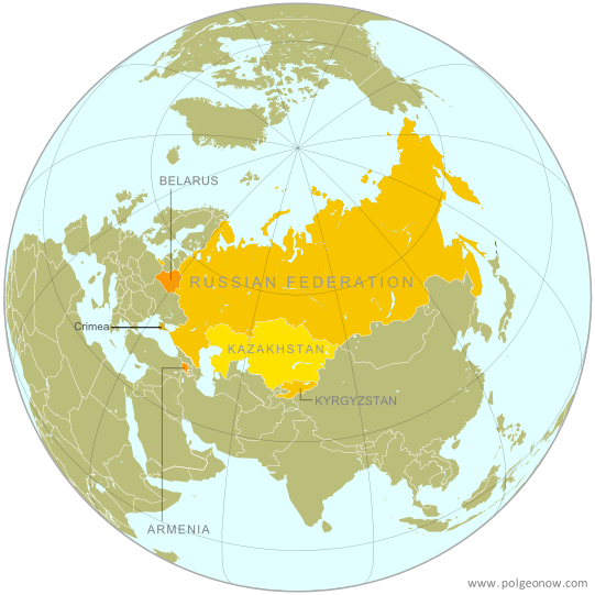 |
| The Eurasian Economic Union's five current member countries, plus disputed Crimea, claimed to be part of Russia. Map by Evan Centanni, starting from this map by Keverich2. License: CC BY-SA |
Thursday, April 30, 2015
Map: Seychelles Join WTO
Paid subscribers click here to view this article in the ad-free members area. Not a subscriber yet? Subscribe now!
 |
| Member and observer states of the World Trade Organization (WTO). Map by Evan Centanni, starting from public domain blank map (license: CC BY-NC-SA). |
Tuesday, April 21, 2015
What is the "Eurasian Union"? (Map)
The Russia-led Eurasian Economic Union, sometimes simply called the "Eurasian Union", was officially launched at the beginning of this year. Read on for a brief introduction to this major new regional organization, which you can expect to hear a lot more about in the coming months and years!
Premium members click here to view this article in the ad-free members area. Not a member yet? Subscribe now!
Article by Karina Barquet
 |
| The Eurasian Economic Union's four current member countries, plus disputed territories officially or unofficially included in the common market. Map by Evan Centanni, starting from this map by Keverich2. License: CC BY-SA |
Article by Karina Barquet
Saturday, April 11, 2015
Syria Civil War Control Map: April 2015 (Subscription)
There are newer versions of this map available. To see them, view all Syria updates.

Research by T.H., with additional reporting by Evan Centanni
Since January, the Islamic State has captured part of Syria's capital city, while rebels have gained important ground in both the north and the south. Meanwhile, Kurdish militias have scored victories against the Islamic State on the northeastern front.
See all this and more on the newest update to PolGeoNow's popular Syria control map, and read a timeline of changes since our previous Syria map report at the end of January.
This map and report are exclusive premium content, available to paid subscribers or for separate purchase.
Download PDF (US$19.99)
Exclusive map report includes:
MEMBERS CLICK HERE TO PROCEED TO ARTICLE AND MAP
NOT A MEMBER YET? SUBSCRIBE NOW!

Download PDF: Buy now |
Since January, the Islamic State has captured part of Syria's capital city, while rebels have gained important ground in both the north and the south. Meanwhile, Kurdish militias have scored victories against the Islamic State on the northeastern front.
See all this and more on the newest update to PolGeoNow's popular Syria control map, and read a timeline of changes since our previous Syria map report at the end of January.
This map and report are exclusive premium content, available to paid subscribers or for separate purchase.
Download PDF (US$19.99)
Exclusive map report includes:
- Up-to-date map of current territorial control in Syria, color-coded for the Assad government, rebel groups, Islamic State (ISIS/ISIL) extremists, and Kurdish self-protection forces
- Detailed indication of city-by-city control, highlighting key towns and other locations relevant to current events
- Locations of recent fighting and military operations, including Yarmouk, Idlib, Nassib border crossing, Busra, and the Tomb of Suleyman Shah (site of Turkey's brief military incursion in February).
- Timeline of changes to important events since the end of January, plus summary of important territorial changes in recent months.
MEMBERS CLICK HERE TO PROCEED TO ARTICLE AND MAP
NOT A MEMBER YET? SUBSCRIBE NOW!
Friday, April 3, 2015
War in Yemen: Map of Territorial Control (April 2015)
Note: There are newer versions of this map available.
This is the second in a two-part report on the ongoing crisis in Yemen, a collaboration between PolGeoNow and CIGeography. Part 1 was the Map & Infographic of Foreign Military Deployments in Yemen.
The below article summarizes the political situation and presents a detailed chronicle of events over the past several months. The map has been updated since Wednesday's infographic.
Subscribers click here to view this article in the ad-free members area. Not a member yet? Subscribe now!
Timeline by Djordje Djukic, with additional reporting by Evan Centanni
The Disintegration of Yemen
When PolGeoNow published our last Yemen control map two and a half years ago, the country appeared to be holding together, if only barely. Authoritarian president Ali Abdullah Saleh had stepped down in an internationally-backed political compromise to end the country's Arab Spring uprising, and the northern Houthi rebels had halted their advances after promises of political involvement.
Al Qaeda was on the run from its claimed emirates in the south after a military campaign overseen by the new President Abdurabuh Mansur Hadi, Saleh's former vice president. A movement for southern independence remained outspoken, but wasn't taking up arms in large numbers against the government.
This is the second in a two-part report on the ongoing crisis in Yemen, a collaboration between PolGeoNow and CIGeography. Part 1 was the Map & Infographic of Foreign Military Deployments in Yemen.
The below article summarizes the political situation and presents a detailed chronicle of events over the past several months. The map has been updated since Wednesday's infographic.
 |
Map by Louis Martin-Vézian and Evan Centanni (click to enlarge). All rights reserved.
|
Timeline by Djordje Djukic, with additional reporting by Evan Centanni
The Disintegration of Yemen
When PolGeoNow published our last Yemen control map two and a half years ago, the country appeared to be holding together, if only barely. Authoritarian president Ali Abdullah Saleh had stepped down in an internationally-backed political compromise to end the country's Arab Spring uprising, and the northern Houthi rebels had halted their advances after promises of political involvement.
Al Qaeda was on the run from its claimed emirates in the south after a military campaign overseen by the new President Abdurabuh Mansur Hadi, Saleh's former vice president. A movement for southern independence remained outspoken, but wasn't taking up arms in large numbers against the government.
Wednesday, April 1, 2015
War in Yemen: Map & Infographic of Foreign Military Deployments
This infographic map is a collaboration between PolGeoNow and CIGeography, a site focusing on infographics of military operations related to current events. For details on recent changes to territorial control and the political situation in Yemen, see our companion article, War in Yemen: Map of Territorial Control.
Subscribers click here to view this article in the ad-free members area. Not a member yet? Subscribe now!
This map has also been posted at CIGeography and CIMSEC.
Following this story? View all Yemen maps on PolGeoNow.
 |
Map graphic by Louis Martin-Vézian and Evan Centanni (click to enlarge). All rights reserved.
|
This map has also been posted at CIGeography and CIMSEC.
Following this story? View all Yemen maps on PolGeoNow.
Monday, March 23, 2015
Map of Boko Haram Control in Nigeria: March 2015 (Subscription)
The best online map of Boko Haram's territorial control - guaranteed!
There are newer versions of this map available. To see them, view all Boko Haram updates.

Research by T.H., with additional reporting by Evan Centanni
Boko Haram has now allegedly teamed up with the Islamic State, but the Nigerian rebel group has recently lost most of its territory to a multi-pronged military campaign involving Nigeria, Chad, Niger, and Cameroon.
This map report illustrates the offensive against Boko Haram and the rebel group's remaining territorial holdings, and includes a summary and timeline of events since our previous Boko Haram map report in January.
This map report is exclusive premium content, available to paid subscribers or for separate purchase. Buy now (US$14.99)
Exclusive map report includes:
MEMBERS CLICK HERE TO PROCEED TO ARTICLE AND MAP
NOT A MEMBER YET? SUBSCRIBE NOW!
There are newer versions of this map available. To see them, view all Boko Haram updates.

Download PDF: Buy now |
Boko Haram has now allegedly teamed up with the Islamic State, but the Nigerian rebel group has recently lost most of its territory to a multi-pronged military campaign involving Nigeria, Chad, Niger, and Cameroon.
This map report illustrates the offensive against Boko Haram and the rebel group's remaining territorial holdings, and includes a summary and timeline of events since our previous Boko Haram map report in January.
This map report is exclusive premium content, available to paid subscribers or for separate purchase. Buy now (US$14.99)
Exclusive map report includes:
- Map of Boko Haram's overall area of control in Nigeria, updated to March 22, 2015.
- Detailed map showing almost every individual town currently or previously held by Boko Haram, as well as the overall extent of rebel territorial control.
- Illustrations of the five major military campaigns that have driven Boko Haram back over the past two months, as well as key locations in neighboring countries.
- Summary and detailed timeline of territorial changes and major events since late January, with links to sources.
MEMBERS CLICK HERE TO PROCEED TO ARTICLE AND MAP
NOT A MEMBER YET? SUBSCRIBE NOW!
Wednesday, March 18, 2015
Ukraine War Rebel Control Map: March 2015 (Subscription)
There are newer versions of this map available. To see them, view all Ukraine updates.

Timeline by Djordje Djukic, with map and additional reporting by Evan Centanni
Fighting in Ukraine has come nearly to a halt with the implementation of February's ceasefire.
This brand new, redesigned map is more accurate and detailed than maps in the news media, showing rebel control as it currently stands alongside the location of important ceasefire lines and buffer zones according to our own careful research.
Included in the report is a detailed accounting of events since our previous Ukraine update in December, compiled by our Ukraine specialist.
This map report is exclusive premium content, available to paid subscribers or for individual purchase.
Buy now (US$14.99)
Exclusive map report includes:
MEMBERS CLICK HERE TO PROCEED TO ARTICLE AND MAP
NOT A MEMBER YET? SUBSCRIBE NOW!
Download PDF: Buy now |
Fighting in Ukraine has come nearly to a halt with the implementation of February's ceasefire.
This brand new, redesigned map is more accurate and detailed than maps in the news media, showing rebel control as it currently stands alongside the location of important ceasefire lines and buffer zones according to our own careful research.
Included in the report is a detailed accounting of events since our previous Ukraine update in December, compiled by our Ukraine specialist.
This map report is exclusive premium content, available to paid subscribers or for individual purchase.
Buy now (US$14.99)
Exclusive map report includes:
- All new, updated map of Donetsk and Luhansk regions, showing actual lines of control
- Map of February 15 ceasefire lines and buffer zones, depicted more accurately and precisely than in major news media sources
- Improved depiction of regional cities and towns, showing past and current rebel control with larger dots for larger population sizes.
- Timeline of events since December, plus summary of major trends
MEMBERS CLICK HERE TO PROCEED TO ARTICLE AND MAP
NOT A MEMBER YET? SUBSCRIBE NOW!
Wednesday, February 25, 2015
War in Iraq: Map of Control in February 2015 (Subscription)
There are newer versions of this map available. To see them, view all Iraq updates.

Timeline by Djordje Djukic; map and additional reporting by Evan Centanni
The Islamic State has been losing ground in Iraq due to the intervention of two rival air powers: the U.S. and Arab coalition in the west, and an Iranian effort in the east. However, the extremist group has made gains near a major base housing U.S. troops.
See all that and more on this major update to our map of territorial control in Iraq, the first since October. The map and report detail various changes to the control situation on the ground, and also contain updates to the provinces and cities of the Kurdistan region.
This map and article are exclusive member content, accessible only to paid subscribers or by individual purchase. Buy now (US$9.99)
Exclusive report includes:
MEMBERS CLICK HERE TO PROCEED TO ARTICLE AND MAP
NOT A MEMBER YET? SUBSCRIBE NOW!

Download PDF Buy now |
The Islamic State has been losing ground in Iraq due to the intervention of two rival air powers: the U.S. and Arab coalition in the west, and an Iranian effort in the east. However, the extremist group has made gains near a major base housing U.S. troops.
See all that and more on this major update to our map of territorial control in Iraq, the first since October. The map and report detail various changes to the control situation on the ground, and also contain updates to the provinces and cities of the Kurdistan region.
This map and article are exclusive member content, accessible only to paid subscribers or by individual purchase. Buy now (US$9.99)
Exclusive report includes:
- Up-to-date map of current territorial control in Iraq, color-coded for the Iraqi government, ISIS/Islamic State extremists, and Kurdish Peshmerga forces
- Detailed indication of town-by-town control, including provincial boundaries, all major cities, and many smaller ones
- Markers for key areas of recent fighting such as Sinjar, Mosul, Al Asad Airbase, the site of the Barwanah massacre, and more
- Timeline of changes to the situation since October, compiled by our Iraq specialist, with links to sources
MEMBERS CLICK HERE TO PROCEED TO ARTICLE AND MAP
NOT A MEMBER YET? SUBSCRIBE NOW!
Thursday, February 12, 2015
Map: ALBA Has 2 New Member Countries
Subscribers click here to view this article in the ad-free members area. Not a member yet? Subscribe now!
 |
| The Bolivarian Alliance for the Peoples of Our America (ALBA). Map by Evan Centanni. |
Saturday, January 31, 2015
Syria Civil War Map: January 2015 (Premium)
There are newer versions of this map available. To see them, view all Syria updates.

Research by T.H., with additional reporting by Evan Centanni
PolGeoNow presents the newest edition of our in-demand map of territorial control in the Syrian Civil War. The map has been updated to January 30, 2015, showing the recapture of Kobani by Kurdish forces and several other important changes since our previous Syria map report in December.
For the first time, the Syria Civil War Map now uses a different symbol to indicate local control by al-Qaeda affiliate Jabhat al-Nusra, separate from control by other or mixed rebel groups or the Islamic State organization.
This map and report are exclusive premium content, available to paid subscribers or for individual purchase.
Download PDF (US$14.99)
Premium report includes:
MEMBERS CLICK HERE TO PROCEED TO ARTICLE AND MAP
NOT A MEMBER YET? SUBSCRIBE NOW!

Download PDF Buy now |
PolGeoNow presents the newest edition of our in-demand map of territorial control in the Syrian Civil War. The map has been updated to January 30, 2015, showing the recapture of Kobani by Kurdish forces and several other important changes since our previous Syria map report in December.
For the first time, the Syria Civil War Map now uses a different symbol to indicate local control by al-Qaeda affiliate Jabhat al-Nusra, separate from control by other or mixed rebel groups or the Islamic State organization.
This map and report are exclusive premium content, available to paid subscribers or for individual purchase.
Download PDF (US$14.99)
Premium report includes:
- Up-to-date map of current territorial control in Syria, color-coded for the Assad government, rebel groups, Islamic State (ISIS) extremists, and Kurdish self-protection forces
- Al-Qaeda affiliate Jabhat al-Nusra marked with a separate symbol where the group has seized control of towns from other rebel groups
- Detailed indication of city-by-city control, highlighting key towns relevant to current events
- Recent areas of fighting, including Kobani (Ayn al-Arab), Wadi Deif, Sheikh Miskin, and others
- Timeline of changes to territorial control since early December
MEMBERS CLICK HERE TO PROCEED TO ARTICLE AND MAP
NOT A MEMBER YET? SUBSCRIBE NOW!
Thursday, January 29, 2015
Nigeria War Update: Map of Boko Haram Control (January 2015) (Premium)
The best online map of Boko Haram's territorial control - guaranteed!
There are newer versions of this map available. To see them, view all Nigeria updates.

Research by T.H., with additional reporting by Evan Centanni
Since our last Boko Haram control map update in November, the rebel group has expanded its territorial control in Nigeria, connecting two of its territorial enclaves and occupying a long stretch of the country's international border with Niger, Chad, and Cameroon.
This premium report and map detail the various changes of the past two months, including new Boko Haram conquests as well as key attacks that didn't result in territorial gains. The map also, of course, provides an updated illustration of the full extent of Boko Haram's territorial control.
This map and article are exclusive premium content, available only to paid members or for individual purchase. Buy now (US$9.99)
Premium report includes:
MEMBERS CLICK HERE TO PROCEED TO ARTICLE AND MAP
NOT A MEMBER YET? SUBSCRIBE NOW!
There are newer versions of this map available. To see them, view all Nigeria updates.

Download PDF Buy now |
Since our last Boko Haram control map update in November, the rebel group has expanded its territorial control in Nigeria, connecting two of its territorial enclaves and occupying a long stretch of the country's international border with Niger, Chad, and Cameroon.
This premium report and map detail the various changes of the past two months, including new Boko Haram conquests as well as key attacks that didn't result in territorial gains. The map also, of course, provides an updated illustration of the full extent of Boko Haram's territorial control.
This map and article are exclusive premium content, available only to paid members or for individual purchase. Buy now (US$9.99)
Premium report includes:
- Map of Boko Haram's overall area of control in Nigeria, updated to Jan. 28, 2015.
- Detailed map showing almost every individual town or village known to be held by the group, as well as recent locations of major attacks, such as Baga, Monguno, Maiduguri, and Damataru.
- Also shows attacks across the border in Cameroon.
- Summary and detailed timeline of territorial changes and major events since late November, with sources cited.
MEMBERS CLICK HERE TO PROCEED TO ARTICLE AND MAP
NOT A MEMBER YET? SUBSCRIBE NOW!
Friday, January 23, 2015
2014: The Year in Political Geography Changes
Premium members click here to view this article in the ad-free members area. Not a member yet? Subscribe now!
Inside this Review of 2014:
(Note: For extra coverage of political geography events in 2015, follow us on Twitter!)
 |
| Scotland said "NO" to independence in a close vote last September. |
- New countries & breakaway states
- Membership in international organizations
- Recognition of disputed countries
- Territorial disputes
- Rebel control
- Sea borders and seabed claims
- New states and provinces
- Changes to world time zones
- And more!
(Note: For extra coverage of political geography events in 2015, follow us on Twitter!)
Wednesday, January 7, 2015
Lithuania Joins the Eurozone (map)
Even as doubts persist about the future of the euro, and talk is in the air about a possible exit for Greece, other countries have still moved forward with adopting the currency. One such country joined the Eurozone just last week.
Premium members click here to view this article in the ad-free members area. Not a member yet? Subscribe now!
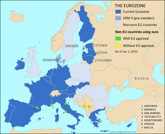 |
| The Eurozone, European Union, and other countries using the euro. Map by Evan Centanni, from blank map by Ssolbergj. License: CC BY-SA |
Subscribe to:
Posts (Atom)