Tuesday, November 10, 2020

Nagorno-Karabakh Control Map & Timeline: Peace Deal Reached - November 10, 2020 (Subscription)

SUBSCRIBERS CLICK HERE TO PROCEED TO ARTICLE AND MAP

There are newer versions of this map available. To see them, view all Nagorno-Karabakh articles on PolGeoNow.

Map by Evan Centanni, Djordje Djukic, Bourrichon, and Lesqual

Subscribe for full access to all conflict map reports!

Preview thumbnail of Nagorno-Karabakh control map, showing territorial claims and control in the Azerbaijan-Armenia war, including the self-proclaimed Republic of Artsakh. Updated to November 10, 2020, the date when the Russia-brokered ceasefire went into effect. Colorblind accessible.
The six-week war between Azerbaijan and the Armenia-backed, self-proclaimed Republic of Artsakh has come screeching to a halt with a new Russia-brokered peace agreement. Azerbaijan has captured ever-bigger sections of the disputed Nagorno-Karabakh region, and will hold onto them under the terms of the new deal.

See all this and more on the latest update to PolGeoNow's concise, professional map of control in the Armenia-Azerbaijan war, which includes a timeline of territorial changes and key events since our previous Nagorno-Karabakh map report of October 25, with sources cited.

This map and report are premium content, available to paid subscribers of the PolGeoNow Conflict Mapping Service.

Want to see before you subscribe? Check out our most recent FREE SAMPLE Nagorno-Karabakh map!

Exclusive map report includes:

  • Up-to-date illustration of current territorial control in Azerbaijan, Armenia, and the disputed Nagorno-Karabakh region, including the self-proclaimed Republic of Artsakh. Areas of mixed or unclear control indicated separately. Colorblind accessible. 
  • Claimed borders of the Republic of Artsakh, as well as the former extent of the Soviet-era Nagorno-Karabakh Autonomous Oblast (NKAO).
  • Indication of town-by-town control along the frontlines.
  • Locations of recent fighting and other important events, including Shusha, Qubadli, Lachin, and more.
  • Detailed timeline of territorial control changes and key military/political developments since October 25, 2020, with sources cited. 

SUBSCRIBERS CLICK HERE TO PROCEED TO ARTICLE AND MAP

Not signed up yet? Click here to learn more about our professional subscription service!

Monday, November 2, 2020

3 Election Day Referendums that Could Change US Geography (Updated with Results)

Update: All three referendums passed, and as of January 2021 the results of two have gone into effect. Scroll down to the bottom of each section for details of what happened.

Map of the United States, showing the 50 states and the District of Columbia (DC)
The US has 50 states...for now. (Map from Wikimedia Commons; CC BY-SA)
 

US Voters to Decide in Geography-related Referendums

This Tuesday - November 3, 2020 - is election day in the United States. And while presidential rivals Donald Trump and Joe Biden have dominated the news, Americans will also be voting (or have already voted) in thousands of other elections for national, state, and local politicians, plus referendums on state and local issues.

The US has no process for nationwide referendums, but statewide referendums - often known as "ballot measures", "propositions", or just "questions" - are common. They also exist at many lower levels of government, and in territories that aren't part of any state, like the national capital district and overseas dependencies. This Tuesday, there will be 120 statewide referendums, all held within 32 of the country's 50 states, plus 3 referendums at the top level of government for other territories.

While most of these votes are on issues like taxation, election rules, and drug laws, three are of special interest to geography fans:

Saturday, October 31, 2020

Yemen Control Map & Report - October 2020

There are newer versions of this map available. To see them, view all Yemen articles on PolGeoNow.

Map of what's happening in Yemen as of October 2020, including territorial control for the unrecognized Houthi government, president-in-exile Hadi and his allies in the Saudi-led coalition, the UAE-backed southern separatist Southern Transitional Council (STC), and Al Qaeda in the Arabian Peninsula (AQAP). Includes recent locations of fighting and other events, including Al Amud, Al Khanjar base, Durayhimi, and more.
Map by Evan Centanni and Djordje Djukic, from base map by Koen Adams of onestopmap.com.
Contact us for permission to use this map.

(Subscribers click here to view this article in the member area)

Timeline by Djordje Djukic

Houthi Control Expanding

In the two months since PolGeoNow's previous Yemen control map report, Houthi fighters have continued their gradual advance against forces loyal to the Saudi-backed, internationally-recognized government of President Abdrabbuh Mansur Hadi. Most of the changes have taken place in Marib province, east of the capital, where the Houthis have expanded their control of the province's western and southern reaches. Meanwhile, southern separatists and Al Qaeda fighters continue to govern other parts of the country relatively undisturbed.


Thursday, October 29, 2020

Puerto Rico: 52nd State of the US? (2020 Referendum - Updated with Results)

In 2012, we reported on Puerto Rico's chances at becoming the a state of the US, after the territory's people sort of voted for that. This is an updated and expanded version of that article, fully revised for next week's new Puerto Rico statehood referendum. 

Continue reading to learn why this time might be different, and why Puerto Rico could become the 52nd state of the US instead of the 51st!

For updates on the results of the referendum, scroll to the bottom of this article.


Puerto Rico Statehood Vote: Different This Time

The US territory of Puerto Rico. (Public domain map from CIA World Factbook)

The US territory of Puerto Rico, made up of one large island and several smaller ones in the Caribbean, doesn't have any say in next week's US presidential election. 

But its people will still have something important to vote on next Tuesday: a referendum on whether to fully join the US as one of the country's states. 

Like in previous votes, the result is non-binding: It can only take effect if approved by the US government. But that doesn't mean it's just a symbolic move.

FAQ: What is Puerto Rico? Is it part of the United States? (Updated)

It's 2020, and Puerto Rico is voting again on whether to become a state of the United States. But what exactly is it now? Is Puerto Rico part of the United States, and can its people vote in US elections? Find all your answers here! 

This is a revised and expanded version of an explainer we originally published in November 2012.

Is Puerto Rico a state of the US? If not, then what is it?

The US territory of Puerto Rico. (Public domain map from CIA World Factbook)
Puerto Rico, a Spanish-speaking island region in the Caribbean, is a United States territory, but not one of the country's 50 states. 

Since it was taken from Spain in the Spanish-American War of 1898, Puerto Rico has been an overseas territory of the United States (known in US legal jargon as an "insular area").  

Monday, October 26, 2020

Nagorno-Karabakh (Artsakh) Control Map & Timeline - October 25, 2020 (Subscription)

SUBSCRIBERS CLICK HERE TO PROCEED TO ARTICLE AND MAP

There are newer versions of this map available. To see them, view all Nagorno-Karabakh articles on PolGeoNow.

Map by Evan Centanni, Djordje Djukic, Bourrichon, and Lesqual

Subscribe for full access to all conflict map reports!

Nagorno-Karabakh control map, showing territorial claims and control in the new Azerbaijan-Armenia war, including the self-proclaimed Republic of Artsakh. Updated to October 2, 2020, showing claimed Azerbaijani advances around the edges of the disputed territory. Colorblind accessible.
In the first few weeks of the new war, Azerbaijan's forces have managed to capture significant stretches of rural territory governed by the Armenia-affiliated, self-proclaimed Republic of Artsakh. However, the region's core remains solidly under Artsakh/Armenian control, with towns around the periphery marking the hotly-contested frontlines.

See all this and more on the latest update to PolGeoNow's concise, professional map of control in the Armenia-Azerbaijan war, which includes a timeline of territorial changes and key events since our previous Nagorno-Karabakh map report of October 2, with sources cited.

This map and report are premium content, available to paid subscribers of the PolGeoNow Conflict Mapping Service.

Want to see before you subscribe? Check out our most recent FREE SAMPLE Nagorno-Karabakh map!

Exclusive map report includes:

  • Up-to-date illustration of current territorial control in Azerbaijan, Armenia, and the disputed Nagorno-Karabakh region, including the self-proclaimed Republic of Artsakh. Areas of mixed or unclear control indicated separately. Colorblind accessible. 
  • Claimed borders of the Republic of Artsakh, as well as the former extent of the Soviet-era Nagorno-Karabakh Autonomous Oblast (NKAO).
  • Indication of town-by-town control along the frontlines.
  • Locations of recent fighting and other important events, including Hadrut, Jabrayil, Zenglan, Talish, and more.
  • Detailed timeline of territorial control changes and key military/political developments since October 2, 2020, with sources cited. 
  • Summary of the conflict situation and changes to the map over the past three weeks.

SUBSCRIBERS CLICK HERE TO PROCEED TO ARTICLE AND MAP

Not signed up yet? Click here to learn more about our professional subscription service!

Sunday, October 25, 2020

African Union Un-Suspends Mali (Map)

Correction (Sep. 2023): It's since come to our attention that South Sudan's suspension had already been lifted at the time this article was published. For details, see our September 2023 African Union map update. The text of this article has now been corrected, but the map has not.

African Union: Map of Africa showing which countries are in the African Union in 2020, including active and suspended member countries and non-member territories. Updated for the October 2020 reinstatement of Mali (colorblind accessible).
Map by Evan Centanni, from blank map by Eric Gaba. License: CC BY-SA

African Union Lifts Suspension of Mali

Less than two months after the African Union (AU) suspended Mali from membership in the continental organization, it ended the suspension earlier this month. It had been suspended after a military faction overthrew the government, but the recent appointment of a civilian-led transitional government have led the AU to lift its suspension. The Economic Community of West African States (ECOWAS), from which Mali was also suspended in August, has lifted the economic sanctions that it posed on the member country. However, the suspension of Mali's voting rights in ECOWAS bodies, which was imposed at the same time, seems to still be in place.

Tuesday, October 20, 2020

Somalia Control Map & Timeline - October 2020 (Subscription)

SUBSCRIBERS CLICK HERE TO PROCEED TO ARTICLE AND MAP

There are newer versions of this map available. To see them, view all Somalia articles on PolGeoNow.

Map by onestopmap.com, Evan Centanni, and Djordje Djukic

Subscribe for full access to all conflict map reports!

Who controls Somalia? Map (October 2020). With states, regions, and territorial control. Best Somalia control map online, thoroughly researched, detailed but concise. Shows territorial control by Federal Government of Somalia (FGS), Al Shabaab, so-called Islamic State (ISIS/ISIL), separatist Somaliland, autonomous state Puntland, and boundaries of additional federal member states Galmudug, Jubaland, South West, and Hirshabelle. Now labels state capitals and disputed boundaries between Somaliland and Puntland, as well as key towns from the news such as Kurtunwarey, Gendershe, Daynunay, Mubarak, Bulacle, and more. Updated to October 20, 2020. Colorblind accessible.
In the last five months, Somalia's federal government and its allies have made modest gains against Al Shabaab, capturing the first district capital in two years. Meanwhile Galmudug state, under new leadership, has become increasingly integrated with the federal-aligned military coalition.

See all this and more on the latest update to PolGeoNow's concise, professional Somalia control map, which includes a timeline of territorial changes and key events since our previous Somalia map report of May 2020, with sources cited.

This map and report are premium content, available to paid subscribers of the PolGeoNow Conflict Mapping Service.

Want to see before you subscribe? Check out our most recent FREE SAMPLE Somalia map!

Exclusive map report includes:

  • Up-to-date illustration of current territorial control in Somalia, color-coded for the federal government coalition (including AMISOM peacekeepers), autonomous unionist forces, separatist Somaliland, Al Qaeda affiliate Al Shabaab, and fighters aligned with the so-called "Islamic State" (IS; formerly ISIS/ISIL). Areas of mixed or unclear control indicated separately. Colorblind accessible.
  • Boundaries and labels for Somalia's official regions and states, including the self-proclaimed independent Republic of Somaliland and federal states Puntland, Galmudug, Jubaland, South West, and Hirshabelle. Illustrates the claims of both sides in the Somaliland-Puntland border dispute, as well as actual control.
  • Detailed indication of city-by-city control, including many relevant smaller towns and villages.
  • Locations of recent fighting and other important events, including Kurtunwarey, Gendershe, Daynunay, Mubarak, Bulacle, and more.
  • Detailed timeline of territorial control changes and key political developments since May 20, 2020, with sources cited. 
  • Summary of the conflict situation and changes to the map over the past five months.

SUBSCRIBERS CLICK HERE TO PROCEED TO ARTICLE AND MAP

Not signed up yet? Click here to learn more about our professional subscription service!

Sunday, October 4, 2020

New Caledonia Turns Down Independence Again

This is a follow-up to our article on New Caledonia's 2020 referendum on independence from France. For more on New Caledonia's current status and what would have happened if the vote had passed, see that article.

The islands of New Caledonia, and their location in the South Pacific. Map by NormanEinstein (CC BY-SA; source)
The results are in for Sunday's independence referendum in New Caledonia and, as in 2018, the majority has voted against seceding from France.

However, the proportion of YES and NO votes wasn't the same as two years ago: Support for independence rose from 43% in 2018 to 47% this time, suggesting that more residents than ever before want an independent country for their island home. Voter turnout was also even higher than last time, rising from 81% to 85%.

So what happens next? Well, for now New Caledonia will keep its current status as an autonomous region of France. But the islands could still become independent in the coming years.

Saturday, October 3, 2020

New Caledonia Voting on Independence from France: Round Two

Update: For the results of the election, check out our follow up article!

This is an updated version of an article published in November 2018 for that year's independence referendum. It has been revised to address the October 2020 vote, which is a direct follow-up to the one two years ago.

The islands of New Caledonia, and their location in the South Pacific. Map by NormanEinstein (CC BY-SA; source)
Today the South Pacific islands of New Caledonia will vote - again - on whether to declare independence, after a 2018 vote supported remaining part of France.

This referendum and the previous one are the culmination of a 20-year process set in motion by the Nouméa Accord of 1998, when the French government agreed to gradually transfer power to the islands' own institutions.

See Also: Results of the 2018 New Caledonia Independence Vote

New Caledonia is one of two places in the Melanesia region to vote on independence lately, after Bougainville chose independence from Papua New Guinea last December (though it's still uncertain if Bougainville will really become independent).

Friday, October 2, 2020

Nagorno-Karabakh (Artsakh) Control Map & Timeline - October 2, 2020

There are newer versions of this map available. To see them, view all Nagorno-Karabakh articles on PolGeoNow.

This is the first edition of our new Nagorno-Karabakh control map series, which we hope to further improve in the near future if the conflict continues. To guarantee your access to future updates, sign up our conflict map subscription service.

Nagorno-Karabakh control map, showing territorial claims and control in the new Azerbaijan-Armenia war, including the self-proclaimed Republic of Artsakh. Updated to October 2, 2020, showing claimed Azerbaijani advances around the edges of the disputed territory. Colorblind accessible.
Map by Evan Centanni and Djordje Djukic, starting from this map by Bourrichon and Lesqual. License: CC BY-SA
(Subscribers click here to view this article in the member area)

Article by Djordje Djukic and Evan Centanni

Armenia and Azerbaijan Go to War

One of the former Soviet Union's "frozen conflicts" has suddenly lurched towards meltdown. The dispute over the Nagorno-Karabakh region in the Caucasus - involving Azerbaijan and Armenia plus the self-proclaimed Republic of Artsakh - has been simmering for decades, with regular border clashes since a full-scale war ended in 1994. But last weekend it launched into its biggest flare-up yet.

Tuesday, September 29, 2020

Ukraine War Control Map & Report: September 2020

To see other maps in this series, plus a new map of Russian control in the 2022 invasion, view all Ukraine articles on PolGeoNow.
Map of territorial control and frontlines in the Donbass region of Donetsk and Luhansk, internationally recognized as part of eastern Ukraine but partly controlled by the breakaway Donetsk People's Republic and Lugansk People's Republic. Updated for September 2020, with Minsk ceasefire lines shown. Colorblind accessible.
Map by Evan Centanni and Djordje Djukic. Contact us for permission to use this map.

(Subscribers click here to view this article in the member area)

Timeline by Djordje Djukic, with additional reporting by Evan Centanni

Donbass Frontline Map

In the four years since PolGeoNow last updated our Ukraine control map, little has changed in terms of territorial boundaries in the region of eastern Europe known as the Donbass. Forces of the Russia-backed self-proclaimed Donetsk People's Republic (DPR) and Lugansk People's Republic (LPR) still hold a large chunk of what most of the world considers Ukraine, though their plans of formally uniting into a confederation of "Novorossiya" ("New Russia") have long gone by the wayside. But as attempts at resolving the conflict peacefully grind slowly forward, fighting has continued at a low level along the frontlines, and we have made some small changes to the map where the situation has either changed or been clarified since 2016.

Wednesday, September 23, 2020

Map & Analysis: Which Countries Recognize Kosovo in 2020?

Announcing the re-launch of our Kosovo recognition updates series! PolGeoNow will now once again be providing timely reports on when countries recognize - or un-recognize - the disputed Republic of Kosovo.

Map of Kosovo recognition, indicating which states (countries) still recognize Kosovo's independence, which have withdrawn recognition, and which claims of recognition have been denied, as of September 2020, including new addition Israel. Colorblind accessible.
Click to enlarge. By Evan Centanni, modified from public domain blank world map.
Contact us for permission to use this map.

Friday, August 28, 2020

Yemen Control Map & Report: Al Qaeda / IS Enclave Eliminated - August 2020 (Subscription)

SUBSCRIBERS CLICK HERE TO PROCEED TO ARTICLE AND MAP

There are newer versions of this map available. To see them, view all Yemen articles on PolGeoNow.

Timeline by Djordje Djukic. Map by Evan Centanni, Djordje Djukic, and onestopmap.com

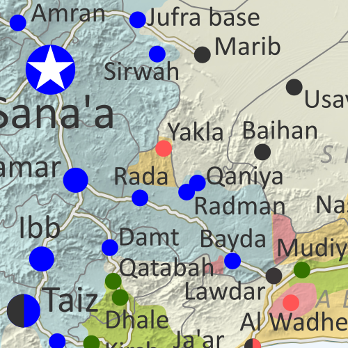
Map of what's happening in Yemen as of August 2020, including territorial control for the unrecognized Houthi government, president-in-exile Hadi and his allies in the Saudi-led coalition, the UAE-backed southern separatist Southern Transitional Council (STC), and Al Qaeda in the Arabian Peninsula (AQAP). Includes recent locations of fighting and other events, including Yakla, Qaniya, Damt, and more.
Subscribe for full access to all conflict map reports!

Over the past month, Yemen's Houthi government has continued slowly gaining ground, both against the internationally-recognized Hadi government and against Al Qaeda and "Islamic State" (ISIS/ISIL) forces.

See all this and more on the newest update to PolGeoNow's Yemen territorial control map, which includes a timeline of changes and important events since our previous Yemen map report in July.

This map and report are premium content available to paid subscribers of the PolGeoNow Conflict Mapping Service.

Want to see before you buy? Check out our most recent FREE SAMPLE Yemen map report!

Exclusive report includes:
  • Up-to-date map of current territorial control in Yemen, color-coded for the pro-Hadi coalition, the separatist Southern Transitional Council (STC), Houthi forces, and Al Qaeda in the Arabian Peninsula (AQAP)
  • Detailed indication of town-by-town control, including provincial boundaries, all major cities, and many smaller ones
  • Markers for recent areas of fighting, including Yakla, Qaniya, Damt, and more
  • Timeline of changes to the situation since July 25, 2020, with links to sources 

SUBSCRIBERS CLICK HERE TO PROCEED TO ARTICLE AND MAP

Not a member yet? Click here to learn more about our professional subscription service!

Can I purchase just this map?
This map and report are not available for automated purchase to non-subscribers. If you need access or republication rights for only this map report, contact service@polgeonow.com for options.

Saturday, August 22, 2020

Iraq Control Map & Timeline: Turkey Expands Control in North - August 2020 (Subscription)

SUBSCRIBERS CLICK HERE TO PROCEED TO ARTICLE AND MAP

(To see other maps in this series, view all Iraq articles.)

Research by Djordje Djukic. Map by onestopmap.com, Evan Centanni, and Djordje Djukic

Subscribe for full access to all conflict map reports!

Iraq Control Map 2020, updated to August 21. Shows areas of Iraq under Turkey's military contro, ISIS control (Islamic State/ISIL/Daesh), and under the control of the Baghdad government, the Kurdistan Peshmerga, and the Yezidi Sinjar Alliance (YBS and YJE). Marks Khamtir and Halukah Mountains (Jabal Khamtir and Jabal Halukah), controlled by Turkish forces. Colorblind accessible.
While Iraq's lines of control have mostly stayed the same since the beginning of the year, Turkey's military has been gradually increasing its control of the north. The incursion is part of the Turkish war against the Kurdish PKK, a rebel group from Turkey that now bases itself across the border in Iraq.

See all this and more on the latest update to PolGeoNow's concise, professional map of control in Iraq, including a timeline of changes since our previous Iraq map report of January 2020.

This map and report are premium content, available to paid subscribers of the PolGeoNow Conflict Mapping Service.

Want to see before you subscribe? Check out our most recent FREE SAMPLE Iraq map report!

Exclusive report includes:
  • Up-to-date map of current territorial control in Iraq, color-coded for the Iraqi government, "Islamic State" (ISIS/ISIL) fighters, Kurdistan's Peshmerga forces, and Yezidi militias. Colorblind accessible.
  • NEW: Turkish military control along the northern border, including key sites Mt. Khamtir (Jabal Khamtir) and Mt. Halukah (Jabal Halukah).
  • Detailed indication of town-by-town control, including all major cities and many smaller ones, as well as terrain, major roads, and provincial boundaries
  • Timeline of changes to the situation and related events since January, compiled by our Iraq-Syria specialist, with links to sources.
SUBSCRIBERS CLICK HERE TO PROCEED TO ARTICLE AND MAP

Not signed up yet? Click here to learn more about our professional subscription service!

Can I purchase just this map?
This map and report are not available for automated purchase to non-subscribers. If you need access or republication rights for only this map report, contact service@polgeonow.com for options.

Thursday, August 20, 2020

African Union Map Update: Mali & South Sudan Suspended, Sudan Reinstated

African Union: Map of Africa showing which countries are in the African Union in 2020, including active and suspended member countries and non-member territories. Updated for the September 2019 reinstatement of Sudan, the June 2020 suspension of South Sudan, and the August 2020 suspension of Mali (colorblind accessible).
Map by Evan Centanni, from blank map by Eric Gaba. License: CC BY-SA

Mali Suspended from African Union

The African Union (AU) suspended Mali from membership in the continental organization yesterday, after army mutineers marched to country's capital and overthrew the president. Major protests had been calling for the president's resignation for months, but his removal by force has not gone over well with the international community. In addition to the AU, Mali has also been suspended from the Economic Community of West African States (ECOWAS), an important group including most of Mali's neighboring countries.

Monday, August 17, 2020

"Islamic State" in Mozambique? Control Map & Timeline of the Insurgency

There are newer editions of this map available. To see them, view all Mozambique articles on PolGeoNow.

This is the first edition of our new Mozambique control map series. To guarantee your access to future updates, sign up our conflict map subscription service (updates may be released for free if changes end up being very few or far between).

Mozambique Insurgency: Map of ISIS control in Mozambique, or of control by local insurgent group Ahlu Sunnah Wa-Jamâ / Ahlu Sunnah Wa-Jamaa / Ahlu Sunnah Wa-Jamaah (al-Sunna / al-Sunnah) in northern Mozambique's Cabo Delgado province, with territorial control, roads, rivers, and terrain. Includes key locations of the insurgency such as Mocímboa da Praia, Awasse, Macomia, Mucojo, Quissanga, Meluco, Muidumbe, Mueda, Mitumbate (Mutumbate), Palma, Pundanhar, and Nangade, as well as other important cities such as Pemba, Nampula, and Maputo. Neighboring countries shown, including Comoros, Madagascar, and French territories of Juan de Nova Island, Bassas da India, and Europa Island. Updated to August 17, 2020. Colorblind accessible.
Map by Evan Centanni and Djordje Djukic. Contact us for permission to use this map. Terrain data sourced from ViewFinderPanoramas.

(Subscribers click here to view this article in the member area)

Article by Evan Centanni and Djordje Djukic

Northern Mozambique's Insurgency: What We Do and Don't Know

Mozambique: Cabo Delgado insurgency map - October 2017 to August 2020: Detailed, close-up control map showing areas occupied by so-called ISIS-linked rebels in northern Mozambique (also known as Ahlu Sunnah Wa Jama, ASWJ, or Ansar al-Sunnah), plus towns and villages raided by the insurgents over the past three years. Shows roads, rivers, and terrain, and includes key locations of the insurgency such as MocĂ­mboa da Praia, Awasse, Macomia, the Total LNG site and natural gas fields, Miangalewa, Litingina, Ntessa, Cagembe, Marere, Makulo, and many, many more. Colorblind accessible.
Close-up version of the above map, with expanded timeline (subscriber exclusive; click for more info).
International headlines broke last week describing a takeover of a northern Mozambique "city" by what many of them called the "Islamic State" (IS; formerly ISIS/ISIL). If this came as a complete surprise to you, you're not alone - even international analysts were startled when the insurgency began in 2017, and though the insurgents have actually overrun MocĂ­mboa da Praia more than once since then, news coverage has been pretty limited.

At PolGeoNow, researcher Djordje Djukic has been keeping an eye on this conflict for some time, and we're now pleased to present what we believe to be the world's first map series documenting territorial control in the northern Mozambique insurgency. 

Update: A much more detailed close-up version of the above map, adding insurgent raids and accompanied by an expanded timeline, is now available to our paid subscribers.

Monday, August 10, 2020

All About Kazakhstan's 2019 Capital Name Change

At PolGeoNow, our goal is to inform you whenever a country changes its name, capital, or flag. So even though we sometimes fall behind, we want to make sure you don't miss out completely on stories like this one from last year.

Map of Kazakhstan and the location of its capital city, Nur-Sultan (Nursultan), formerly Astana, as well as largest city Almaty
Contact us for permission to use this map.

Astana is Now Nur-Sultan

In March of last year, the Republic of Kazakhstan in central Asia announced that it was changing the name of its capital city. The day after President Nursultan Nazarbayev announced his resignation, the incoming interim president declared that the city, Astana, would be renamed "Nur-Sultan" in honor of the previous president.

Friday, July 31, 2020

Syria Control Map & Report: Frontlines Stable - July 2020

There are newer versions of this map available. To see them, view all Syria updates.

This is a free edition of our Syria control map series. If you want access to our full collection of Syria maps, you can sign up for our conflict map subscription service. 

Syrian Civil War map: Territorial control in Syria in late July 2020 (Free Syrian Army rebels, Kurdish YPG, Syrian Democratic Forces (SDF), Hayat Tahrir al-Sham (HTS / Al-Nusra Front), Islamic State (ISIS/ISIL), and others). Includes Turkish/TFSA control, joint SDF-Assad control, US deconfliction zone, and Turkey-Russia security corridor, plus recent locations of conflict and territorial control changes, including Suknah, Abu Kamal, Idlib, and more. Colorblind accessible.
Base map by Koen Adams of onestopmap.com, with territorial control by Evan Centanni and Djordje Djukic.
Contact us for permission to use this map.

(Subscribers click here to view this article in the member area)

Timeline by Djordje Djukic

Syrian Civil War Update: July 2020

In the four months since our previous Syria control map report, the lines of control have almost all stayed the same, with back-and-forth fighting between the sides not resulting in lasting territorial changes. The exception is in Syria's central desert, where estimates of so-called "Islamic State" (IS; formerly ISIS/ISIL) control have shrunk to include only the area surrounding the Doubayat Gas Field. Meanwhile, joint Russian-Turkish patrols have begun along the Idlib "security corridor", and Israeli airstrikes against Iranian and Hezbollah forces have become common.

Sunday, July 26, 2020

Yemen Control Map & Report: Separatists Take Socotra - July 2020 (Subscription)

SUBSCRIBERS CLICK HERE TO PROCEED TO ARTICLE AND MAP

There are newer versions of this map available. To see them, view all Yemen articles on PolGeoNow.

Timeline by Djordje Djukic. Map by Evan Centanni, Djordje Djukic, and onestopmap.com

Map of what's happening in Yemen as of July 2020, including territorial control for the unrecognized Houthi government, president-in-exile Hadi and his allies in the Saudi-led coalition, the UAE-backed southern separatist Southern Transitional Council (STC), and Al Qaeda in the Arabian Peninsula (AQAP). Includes recent locations of fighting and other events, including Socotra, Qaniya, Radman, Ja'ar, Jardan, and more.
Subscribe for full access to all conflict map reports!

In the last two months, Yemen's internationally-recognized government has lost more ground to both northern Houthi forces and southern separatists, including a separatist takeover over the entire island province of Socotra.

See all this and more on the newest update to PolGeoNow's Yemen territorial control map, which includes a timeline of changes and important events since our previous Yemen map report in May.

This map and report are premium content available to paid subscribers of the PolGeoNow Conflict Mapping Service.

Want to see before you buy? Check out our most recent FREE SAMPLE Yemen map report!

Exclusive report includes:
  • Up-to-date map of current territorial control in Yemen, color-coded for the pro-Hadi coalition, the separatist Southern Transitional Council (STC), Houthi forces, and Al Qaeda in the Arabian Peninsula (AQAP)
  • Detailed indication of town-by-town control, including provincial boundaries, all major cities, and many smaller ones
  • Markers for recent areas of fighting, including Hadibu, Qaniya, Radman, Ja'ar, Jardan, and more
  • Timeline of changes to the situation since May 20, 2020, with links to sources 

SUBSCRIBERS CLICK HERE TO PROCEED TO ARTICLE AND MAP

Not a member yet? Click here to learn more about our professional subscription service!

Can I purchase just this map?
This map and report are not available for automated purchase to non-subscribers. If you need access or republication rights for only this map report, contact service@polgeonow.com for options.