Showing posts with label europe. Show all posts

Tuesday, June 21, 2016

On the Ground: Gibraltar and the "Brexit" Referendum

This is the first installment of PolGeoNow's On the Ground, a new series of exclusive photo essays on what political geography looks like in the real world. Whether it's borders, nationalism, or other geopolitical phenomena, we'll bring the on-the-ground situations to your screen in vivid detail.

Update 2016-06-24: Gibraltar on Thursday voted in favor of the UK staying in the European Union, by an incredible margin of  96% to 4%. However, the UK as a whole voted to leave the EU, meaning that Gibraltar can expect to get pulled out with it, against the wishes of the Gibraltarians.
 
Photo of the Gibraltar Stronger in Europe campaign office on the British territory's main street. Gibraltar's population is overwhelmingly against a so-called Brexit, or departure of the UK from the European Union.
Subscribers click here to view this article in the ad-free members area. Not a member yet? Learn about PolGeoNow subscriptions!

Map of Gibraltar and its location in Europe relative to the UK and Spain
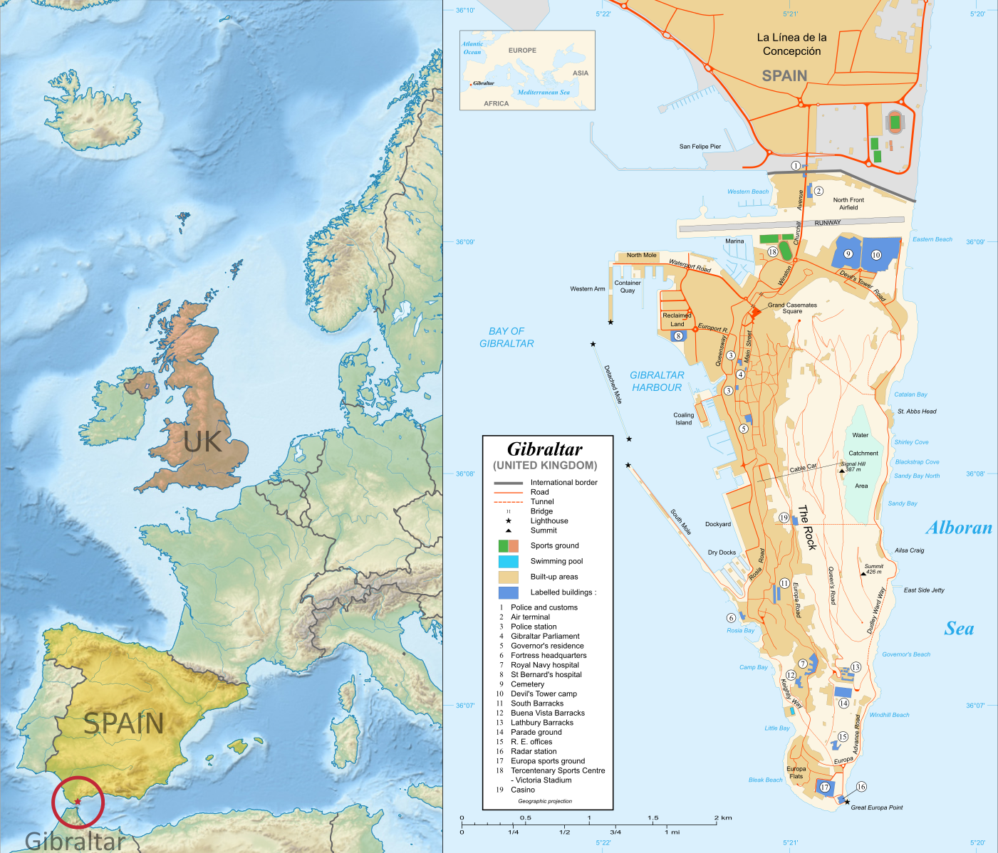
Right: Map of Gibraltar by Eric Gaba (source; CC BY-SA)
Left: Gibraltar's location in Europe (based on this Wikimedia Commons map by TUBS; CC BY-SA)
Gibraltar prepares to vote on whether UK should leave European Union
Last month, PolGeoNow's Evan Centanni and Meihsing Kuo visited the small British territory of Gibraltar (pronounced "jih-BRALL-ter"), one month ahead of the UK's referendum on whether to leave or remain in the European Union (EU).

Gibraltar, a tiny peninsula connected to Spain - and claimed by the Spanish government - is the only British overseas territory that's part of the EU. It's also the only external territory whose residents are eligible to vote in the so-called "Brexit" referendum without living in the UK proper. ("Brexit" is an abbreviation for "British exit" from the EU.)

Wednesday, June 8, 2016

Ukraine War Control Map & Report: June 2016

There are newer versions of this map available. To see them, view all Ukraine updates.

Subscribers click here to view this article in the ad-free members area. Not a member yet? Learn about PolGeoNow subscriptions!
Map of rebel territorial control in Ukraine's eastern provinces of Donetsk and Luhansk, claimed by the breakaway Donetsk People's Republic and Lugansk People's Republic. Updated for June 2016, with Minsk ceasefire lines shown.
Map by Evan Centanni (all rights reserved)
Timeline by Djordje Djukic, with additional reporting by Evan Centanni

Summary of Developments
PolGeoNow's previous Ukraine control map report was published in March of last year, just a month after a ceasefire was implemented under the Minsk II agreement, a hard-won deal between the Kiev government and representatives of the self-proclaimed Donetsk and Lugansk People's Republics (established by rebels with extensive support from the other side of the Russian border). Since then, the ceasefire has broadly held, which explains why the war in eastern Ukraine has largely dropped out of world newspaper front pages. However, fighting has continued off and on at a reduced level, and the ceasefire agreement is still on shaky ground. This map and timeline report describe what has happened over the past year, including some small changes to territorial control.

Thursday, March 3, 2016

Map of Temporary Border Controls in the Schengen Area, March 2016

There are newer versions of this map available. To see them, view all Schengen Area articles.

In the companion to this article, we explain in plain English what the Schengen Area is, and which countries are part of it. Here, we present a map of the area's current crisis, showing where border checks have been reintroduced. Details and explanation in the article below.

Map of Temporarily Reintroduced Border Control in the Schengen Area (the European Union's border-free travel zone), color-coded for EU Schengen countries, non-EU Schengen countries, future Schengen countries, and Schengen-exempt EU countries, as well as microstates unofficially participating in the Schengen agreements (colorblind accessible).

Map by Evan Centanni, from blank map by Ssolbergj. License: CC BY-SA
Subscribers click here to view this article in the ad-free members area. Not a member yet? Learn about PolGeoNow subscriptions!

Article by Evan Centanni

Borders Re-emerging Inside the Schengen Area

Over the past months, concern has been rising that Europe's border-free travel zone, known as the Schengen Area, is falling apart. As unprecedented numbers of refugees and other migrants enter the Schengen Area, individual member countries have begun to re-start border checks in the places where they abolished them decades ago. Read on to learn the why, how, and where of the Schengen Area's new border controls!

Map of the Schengen Area in March 2016

This is an older version of PolGeoNow's Schengen Area map, preserved for historical reference. To see the latest version, visit our updated Schengen Area explainer article.


Map of the Schengen Area (the European Union's border-free travel zone), color-coded for EU Schengen countries, non-EU Schengen countries, future Schengen countries, and Schengen-exempt EU countries, as well as microstates unofficially participating in the Schengen agreements (colorblind accessible).
Map by Evan Centanni, from blank map by Ssolbergj. License: CC BY-SA

Thursday, December 10, 2015

Map: Kazakhstan Joins WTO

Premium members click here to view this article in the ad-free members area. Not a member yet? Learn about our subscription service!

Map of World Trade Organization (WTO) member and observer countries, updated for December 2015 to include new member Kazakhstan
Member and observer states of the World Trade Organization (WTO). Map by Evan Centanni, starting from public domain blank map (license: CC BY-NC-SA).

Friday, June 5, 2015

Vatican City Administration Recognizes Palestine as a Country (map)

(Keep up with changes to Palestine's situation: view all Palestine updates.)

Map of countries that recognize the State of Palestine as an independent country, updated for June 2015 with recent addition Vatican City (Holy See) highlighted
Click to enlarge: Countries recognizing the State of Palestine in green, with most recent addition highlighted. Palestine in magenta (circled). Map by Evan Centanni, modified from public domain graphic (source).
Subscribers click here to view this article in the ad-free members area. Not a member yet? Subscribe now!

Thursday, May 14, 2015

Map: Another Country Joins the "Eurasian Union" (May 2015)

Map of the Eurasian Economic Union (EEU), also known as the Eurasian Union. Includes new member Kyrgyzstan, as well as prior members Russia, Belarus, Kazakhstan, and Armenia, and disputed territory Crimea
The Eurasian Economic Union's five current member countries, plus disputed Crimea, claimed to be part of Russia. Map by Evan Centanni, starting from this map by Keverich2. License: CC BY-SA
Premium members click here to view this article in the ad-free members area. Not a member yet? Subscribe now!

Tuesday, April 21, 2015

What is the "Eurasian Union"? (Map)

The Russia-led Eurasian Economic Union, sometimes simply called the "Eurasian Union", was officially launched at the beginning of this year. Read on for a brief introduction to this major new regional organization, which you can expect to hear a lot more about in the coming months and years!
Map of the Eurasian Economic Union (EEU), also known as the Eurasian Union. Includes new member Armenia, as well as prior members Russia, Belarus, and Kazakhstan, and disputed territories Crimea and Nagorno-Karabakh, as well as acceding member Kyrgyzstan.
The Eurasian Economic Union's four current member countries, plus disputed territories officially or unofficially included in the common market. Map by Evan Centanni, starting from this map by Keverich2. License: CC BY-SA
Premium members click here to view this article in the ad-free members area. Not a member yet? Subscribe now!

Article by Karina Barquet

Wednesday, March 18, 2015

Ukraine War Rebel Control Map: March 2015 (Subscription)

There are newer versions of this map available. To see them, view all Ukraine updates.

Detailed map of pro-Russian rebel control in Ukraine's eastern provinces of Donetsk and Luhansk, claimed by the breakaway Donetsk People's Republic and Lugansk People's Republic. Updated for March 2015, with February ceasefire lines and buffer zones shown. Includes detailed timeline of events since December.

Download PDF:
Buy now


(Subscribe via Paypal to access all premium content online)
Timeline by Djordje Djukic, with map and additional reporting by Evan Centanni

Fighting in Ukraine has come nearly to a halt with the implementation of February's ceasefire.  

This brand new, redesigned map is more accurate and detailed than maps in the news media, showing rebel control as it currently stands alongside the location of important ceasefire lines and buffer zones according to our own careful research.

Included in the report is a detailed accounting of events since our previous Ukraine update in December, compiled by our Ukraine specialist.

This map report is exclusive premium content, available to paid subscribers or for individual purchase.
Buy now (US$14.99)

Exclusive map report includes:
  • All new, updated map of Donetsk and Luhansk regions, showing actual lines of control
  • Map of February 15 ceasefire lines and buffer zones, depicted more accurately and precisely than in major news media sources
  • Improved depiction of regional cities and towns, showing past and current rebel control with larger dots for larger population sizes.
  • Timeline of events since December, plus summary of major trends

MEMBERS CLICK HERE TO PROCEED TO ARTICLE AND MAP

NOT A MEMBER YET? SUBSCRIBE NOW!


Wednesday, January 7, 2015

Lithuania Joins the Eurozone (map)

Even as doubts persist about the future of the euro, and talk is in the air about a possible exit for Greece, other countries have still moved forward with adopting the currency. One such country joined the Eurozone just last week.

Map of the Eurozone (euro area), showing which countries use the euro as their currency. Includes members, pre-members (ERM II), EU non-members using the euro, and other EU countries (colorblind accessible).
The Eurozone, European Union, and other countries using the euro.
Map by Evan Centanni, from blank map by Ssolbergj. License: CC BY-SA
Premium members click here to view this article in the ad-free members area. Not a member yet? Subscribe now!

Tuesday, December 30, 2014

Kosovo Becomes an Olympic Nation

Premium members click here to view this article in the ad-free members area. Not a member yet? Subscribe now!


Map of Serbia, Kosovo, and North Kosovo
Kosovo controversially claims independence from Serbia (Northern Kosovo is under partial pro-Serbian control). Map by Evan Centanni, based on these two blank maps by Nord-NordWest. License: CC BY-SA
By Evan Centanni

Next Stop: Rio 2016
Disputed country Kosovo has become the 205th member of the International Olympic Committee (IOC), making it an official Olympic Nation and allowing it to field a team at the 2016 Olympics in Brazil. Its full acceptance came at an IOC meeting in Monaco on December 9, after being granted "provisional recognition" in October.

Kosovo's admission process has been ongoing for five years, and the self-proclaimed country was denied the chance to participate in the London Olympics of 2012. However, one Kosovan athlete attended the games with the team from Albania, a neighboring country with close cultural ties to Kosovo.

Disputed Status
Located in southeastern Europe, Kosovo controversially declared independence from Serbia in 2008, while under the control of UN peacekeepers. Since then, it has been recognized as independent by over half of the world's countries, including the US and most of the European Union. However, Russia, China and many other countries still consider it to be rightfully part of Serbia.

Monday, December 22, 2014

Ukraine War Rebel Control Map: December 2014 (Premium)

There are newer versions of this map available. To see them, view all Ukraine updates.

Detailed map of pro-Russian rebel control in Ukraine's eastern provinces of Donetsk and Luhansk, claimed by the breakaway Donetsk People's Republic and Lugansk People's Republic. Updated to December 21, 2014

Download PDF
Buy now


(Subscribe via Paypal to access all premium content online)
Research by Djordje Djukic, with additional reporting by Evan Centanni

Control lines have begun to solidify in Ukraine's civil war, with government forces on one side and the fighters of the self-proclaimed Donetsk People's Republic, Lugansk People's Republic, and Federation of Novorossiya on the other side. 

PolGeoNow presents our district-by-district map of control in eastern Ukraine, updated for December 2014, including a timeline of major events and changes to territorial control since our previous Ukraine map update in September.

This map report is exclusive premium content, available to paid subscribers or for individual purchase.
Buy now (US$9.99)

Premium map includes:
  • Detailed, updated map of Donetsk and Luhansk regions, showing both past and current rebel control
  • Indication of which districts and cities have had their administrations occupied by separatists
  • Timeline of changes to territorial control since September, and summary of major trends

MEMBERS CLICK HERE TO PROCEED TO ARTICLE AND MAP

NOT A MEMBER YET? SUBSCRIBE NOW!


Friday, October 24, 2014

Map Update: Kosovo Now Recognized by Every Country in Oceania (107/193 UN members)

Premium members click here to view this article in the ad-free members area. Not a member yet? Subscribe now!
Map of countries that recognize the Republic of Kosovo as an independent state, updated for October 2014, with the most recent addition (Solomon Islands) and disputed recognitions highlighted
Countries recognizing the Republic of Kosovo in green, highlighting recent additions. Disputed recognitions in yellow. Kosovo in magenta. Map by Evan Centanni, modified from public domain graphic (source).

Tuesday, October 14, 2014

Map: "Eurasian Union" Gets New Member

Map of the Eurasian Economic Union (EEU), also known as the Eurasian Union. Includes new member Armenia, as well as prior members Russia, Belarus, and Kazakhstan, and disputed territories Crimea and Nagorno-Karabakh.
The Eurasian Economic Union's four member countries, plus disputed territories that might be officially or unofficially included. Map by Evan Centanni, starting from this map by Keverich2. License: CC BY-SA
Premium members click here to view this article in the ad-free members area. Not a member yet? Subscribe now!

Friday, September 19, 2014

Maps of How Scotland's Regions Really Voted

Good geographers know that maps can lie to you. Every map emphasizes some aspects of a place at the expense of others, giving it a lot of power to lead careless readers astray. Maps of Scotland's recent independence referendum are misleading us about the reality, even if not intentionally.

Premium members click here to view this article in the ad-free members area. Not a member yet? Subscribe now!
 
Map of results in Scotland's September 18, 2014 independence referendum. Voters were polled on whether or not to separate from the UK. Map shows relative proportion of yes and no votes for each of Scotland's council areas, using a gradient rather than contrasting colors for small differences.
Map by Evan Centanni, based on blank map by TUBS and NordNordWest (CC BY-SA)
By Evan Centanni

Misleading Maps
By now you've probably heard the results of Scotland's independence referendum: voters chose "no" by a solid margin of 55% to 45%. Check out our previous article to learn more about what would have happened if Scotland had voted "yes".

Maps like this one from the BBC and this one from Wikipedia have popped up since the results came out, showing how each of Scotland's council areas voted. Most of the country is in red for "no", with a few "yes" areas in green.

But if one area went 51% for "yes", and another 51% for "no", those two areas actually voted almost identically - yet contrasting red/green maps make us feel like they're polar opposites (not to mention that one-in-thirty readers has trouble seeing the difference between red and green).

How the Councils Really Voted
Whether each area's people voted just over or just under 50% in favor isn't actually that important. What matters is how far the balance was tipped in each region. This is not the U.S. presidential election, where the final vote is actually made by delegates obligated to go by the majority in each state. All the votes across Scotland were pooled together to determine the result, so which side of the 50-yard line each area came out on has no effect .

Tuesday, September 16, 2014

Scottish Independence Poll: What is Scotland, and What Will Happen if it Votes to Leave the UK?

Premium members click here to view this article in the ad-free members area. Not a member yet? Subscribe now!
 
Map of Scotland. On September 18, 2014, Scotland will vote on whether to leave the UK and become an independent country.
Map of Scotland by Eric Gaba (source). License: CC BY-SA
By Evan Centanni

Scotland's Independence Vote

On Thursday (September 18), residents of Scotland will vote in a referendum on whether to leave the United Kingdom (UK). But is Scotland a country already? What will happen if voters choose "yes" in the referendum? And what other changes would this bring to Scotland and the UK's political geography? Read on for the answers to these questions and more!

Crash Course: History of Scotland

Scotland is the name of the northern third of Great Britain, the main island of the UK, which is shared with England to the south and Wales to the southwest. It originated as the Kingdom of Alba, an independent Celtic country that was unified around the year 900.

It remained an independent kingdom throughout the Middle Ages, gradually absorbing Anglo-Saxon culture from the south until it came to be ruled by English-speaking monarchs, who called it "Scots" or "Scotland" after the Latin name for the Gaels, the predominant Celtic people of the region.

Tuesday, September 2, 2014

Ukraine War Rebel Control Map: September 2014 (Premium)

There are newer versions of this map available. To see them, view all Ukraine updates.

Detailed map of pro-Russian rebel control in Ukraine's eastern provinces of Donetsk and Luhansk, claimed by the breakaway Donetsk People's Republic and Lugansk People's Republic. Updated to September 1, 2014

Download PDF
buy


(Subscribe via Paypal to access all premium content online)
Russia is now being accused of directly invading eastern Ukraine, and opposition control in the region has seen major changes since our last Ukraine war map update.

This is detailed map and timeline of pro-Russian territorial control in eastern Ukraine's Donetsk and Luhansk regions, home to the claimed Donetsk People's Republic, Lugansk People's Republic, and Federation of Novorossiya. Updated to the start of September 2014.

This map report is exclusive premium content, available to paid subscribers or for individual purchase.
Buy now (US$9.99)

Premium map includes:
  • Detailed, updated map of Donetsk and Luhansk regions, showing both past and current rebel control
  • Indication of which districts and cities have had their administrations occupied by separatists
  • Timeline of changes to territorial control since July, and summary of major trends

MEMBERS CLICK HERE TO PROCEED TO ARTICLE AND MAP

NOT A MEMBER YET? SUBSCRIBE NOW!


Thursday, August 28, 2014

Latvia Joins the Eurozone (map)

This article was originally published as "Map: Which Countries Use the Euro? (Plus: This Year's New Addition)". To see newer versions of the map, view all Eurozone articles on PolGeoNow.


Map of the Eurozone (euro area), showing which countries use the euro as their currency. Includes members, pre-members (ERM II), EU non-members using the euro, and other EU countries (colorblind accessible).
The Eurozone, European Union, and other countries using the euro.
Map by Evan Centanni, from blank map by Ssolbergj. License: CC BY-SA
Premium members click here to view this article in the ad-free members area. Not a member yet? Subscribe now!