 |
Map graphic by Louis Martin-Vézian and Evan Centanni (click to enlarge). All rights reserved.
|
This map has also been posted at CIGeography and CIMSEC.
Following this story? View all Yemen maps on PolGeoNow.
Updates on the world's countries and borders
|
Map graphic by Louis Martin-Vézian and Evan Centanni (click to enlarge). All rights reserved.
|

Download PDF Buy now |

Download PDF Buy now |
 |
| Countries recognizing the State of Palestine in green, with most recent addition highlighted. Palestine in magenta (circled). Click to enlarge. Map by Evan Centanni, modified from public domain graphic (source). |

Download PDF Buy now |
 |
| Map by Evan Centanni, starting from public domain blank map (license: CC BY-NC-SA). |

Download PDF Buy now |
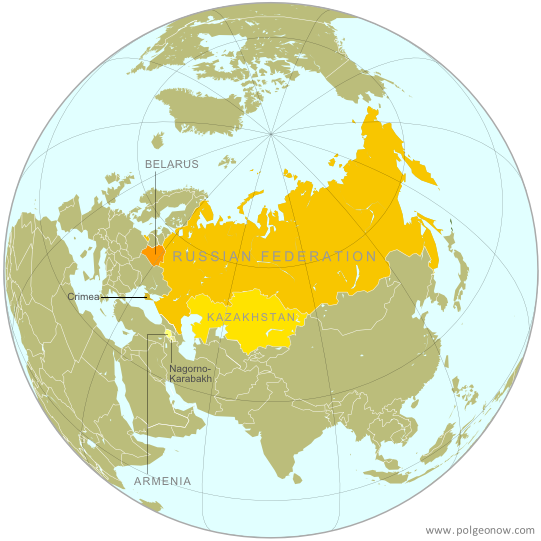 |
| The Eurasian Economic Union's four member countries, plus disputed territories that might be officially or unofficially included. Map by Evan Centanni, starting from this map by Keverich2. License: CC BY-SA |

Download PDF buy |
Download PDF buy |
 |
Territorial control in the Syrian Civil War as of August 2014. Map by Evan Centanni, starting from blank map by NordNordWest. License: CC BY-SA
|

Download PDF buy |
 |
| Member and observer states of the World Trade Organization (WTO). Map by Evan Centanni, starting from public domain blank map (license: CC BY-NC-SA). |

Download PDF buy |

Download PDF buy |
 |
| Control zones based on the Oslo Accords. Area A: Palestinian control; Area B: mixed Israeli-Palestinian control; Area C: full Israeli control. Map by Evan Centanni (sources: Natural Earth, B'Tselem, U.N. OCHA oPt). |

Download PDF buy |

Download PDF buy |

Download PDF buy |
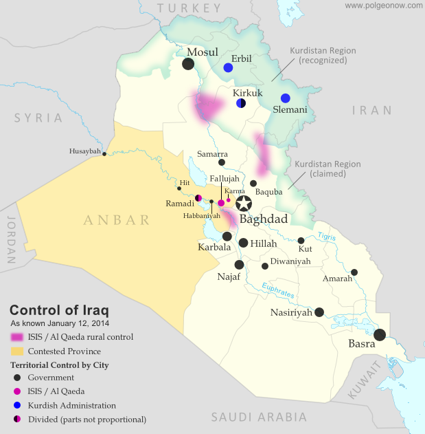 |
Territorial control in Iraq at the beginning of 2014. Map by Evan Centanni, starting from this blank map by German Wikipedia user NordNordWest. License: CC BY-SA
|