Showing posts with label africa. Show all posts

Thursday, May 23, 2013

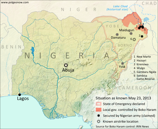
Nigeria Conflict Map: Assault on Boko Haram

There are newer versions of this map available. To see them, view all Nigeria updates.

Nigeria's Boko Haram rebels have been active for some years, but it's only in recent months that they've become known to control territory in the country's far northeast. Now they're facing a full-on assault from the government after the president declared a state of emergency. Read on for details!
Map of Boko Haram control in northeastern Nigeria, and progress made by the government after declaring a state of emergency and launching a military campaign against the rebels in May 2013.
Boko Haram control and the government intervention in Nigeria's northeast. Map by Evan Centanni.

Friday, May 3, 2013

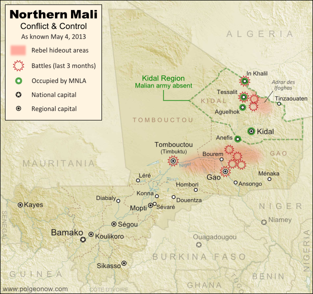
Mali Conflict Map: Hardline Rebels on the Run, Separatists Rebounding (May 2013)

There are newer versions of this map available. To see them, view all Mali maps.  


This is an update within our Mali conflict map series - for the original story, see Mali Map: Islamist Control & French Intervention.

Updated map of fighting and territorial control in Mali during the 2013 French and African intervention against Islamist rebel groups MUJAO, Ansar Dine, and Al Qaeda in the Islamic Maghreb (AQIM). Reflects the situation as of May 4, 2013, including areas occupied by Tuareg rebels of the National Movement for the Liberation of Azawad (MNLA).
Updated map of territorial control and fighting in Mali, as of May 4, 2013. Map by Evan Centanni, modified from Wikimedia map by Orionist, using images by Carport and NordNordWest (source). License: CC BY-SA.
Towns Cleared of Islamist Rebels
Since our last Mali update in February, the country's religious extremist rebel groups have continued their retreat from the northern cities that they controlled for half a year. The military intervention by France and Mali's neighbors has somewhat reunited the country, though with some important exceptions.

Thursday, April 25, 2013

Niger and Burkina Faso Resolve Territorial Dispute

Update: In May 2015, Niger and Burkina Faso formally agreed to implement this ICJ ruling, with the practical aspects of exchanging territories to be completed by the end of the following year.

Map of the disputed territory between Niger and Burkina Faso, which was divided between the two countries in an April 2013 ruling by the International Court of Justice
Map by Evan Centanni. Sources: ICJ, Natural Earth. Africa inset based on this map by TUBS/Wikimedia Commons (CC BY-SA).
By Evan Centanni
 
Border Dispute Settled
Last week, a territorial dispute between the West African countries of Niger and Burkina Faso was resolved peacefully with a ruling from the International Court of Justice (ICJ). Both countries' governments agreed to respect the court's ruling on where their border should lie, a question which had persisted ever since they both achieved independence in 1960.

In the ruling, the court drew an official border based on a careful analysis of a 1927 document establishing the pre-independence boundary between the two former French colonies, also turning to a 1960 French map which both countries had agreed to use as a secondary reference. The new border splits the disputed area between Burkina Faso and Niger, and will help put an end to confusion regarding policing and tax collection in the border area.

Friday, March 22, 2013

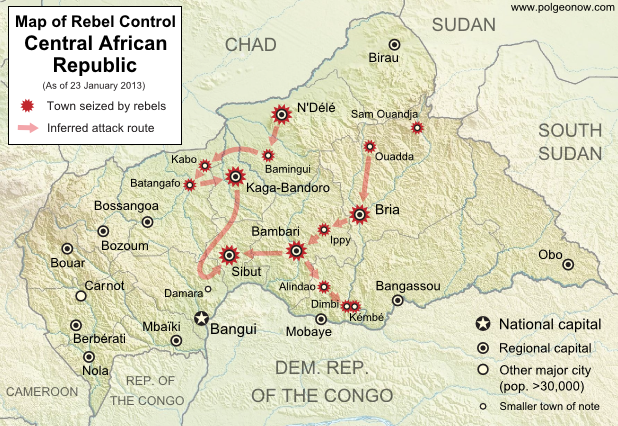
Central African Republic: Map of Rebel Advance to Capital (March 2013)

Last January, rebels in the Central African Republic agreed to a ceasefire with the government, after taking over much of the country. Now, despite the formation of a unity government, the ceasefire has broken down and the rebels are once again advancing on the capital and other towns. Read on for a summary of events. Update (March 24, 2013): The Séléka rebel coalition has now taken the national capital, Bangui.
Map of 2012-2013 rebellion in the Central African Republic, showing current rebel control as of March 24, 2013, from the breakdown of the ceasefire up to the capture of the national capital city, Bangui
Advance of Séléka rebels in the Central African Republic, highlighting attacks occurring since the Jan. 11 ceasefire. Map fact-checked and expanded by Evan Centanni from this map by Wikimedia user Keitsist. License: CC BY-SA
Original Article: Central African Republic - Map of Rebel Control

Ceasefire Violations
After reaching a ceasefire with the government on January 11th, the Central African Republic's Séléka rebel coalition began integration into a new unity government, with several rebel leaders receiving prominent positions in President François Bozizé's cabinet. However, the violence did not end completely.

Tuesday, February 26, 2013

Libya Changes Official Name

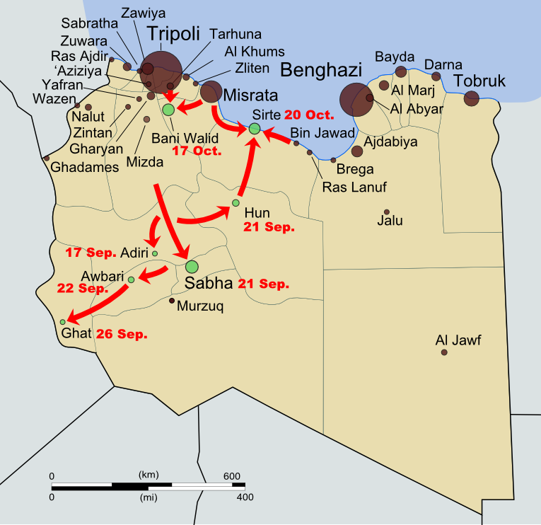
Map of rebel campaigns during the last stage of Libya's 2011 civil war
Map of the last stage of Libya's 2011 civil war (click to see full map and original article). Map by Evan Centanni, based on public domain map from Wikipedia (source).
State of Libya
Last month, the North African country of Libya changed its official long-form name to "State of Libya" (Arabic: Dawlat Libya). This comes as part of Libya's governmental transition following its 2011 civil war, in which a rebel coalition defeated the regime of dictator Muammar Gaddafi.

Over the last year, the country's formal name had not been clearly defined, with the country referred to in most documents simply as "Libya". The rebel National Transitional Council had only made a point of ceasing to use the Gaddafi-era name.

During the last decades of Gaddafi's reign, the country was known in long form as the "Great Socialist People's Libyan Arab Jamahiriya". The word "jamahiriya" was coined by Gaddafi by combining the Arabic words for "republic" (jumhuriya) and "the masses" (jamahir).


Thursday, February 7, 2013

Central African Republic Rebels Join Government (February 2013)

Map of rebel control in the Central African Republic, updated for the reported occupation of Dimbi and Kembe towns after the January 2013 ceasefire
Updated Central African Republic rebel control map. Fact-checked and modified by Evan Centanni from this map by Wikimedia user Keitsist. License: CC BY-SA
Unity Government Announced
After taking control of much of the country in December and January, rebels in the Central African Republic have been given a place in a new unity government that was announced last Sunday. The formation of this government will officially end the country's period of division between the old administration and the "Séléka" rebel coalition.

However, it remains to be seen whether the Central African Republic will truly be reunited in terms of the facts on the ground. Insecurity and chaos has continued at reduced levels since the ceasefire of January 11, with one band of rebels even attacking two more towns during the interim (see updated map at right).

For the full story of Séléka's lighting-fast campaign to control the country, see our previous article Central African Republic: Map of Rebel Control.

Updated Map: Central African Republic - Map of Rebel Control (March 2013)

Saturday, February 2, 2013

Mali Conflict Map: French Take Kidal, Other Towns (February 2013)

There are newer versions of this map available. To see them, view all Mali maps.  


This is an update of our Mali conflict map - for the original story, see Mali Map: Islamist Control & French Intervention.

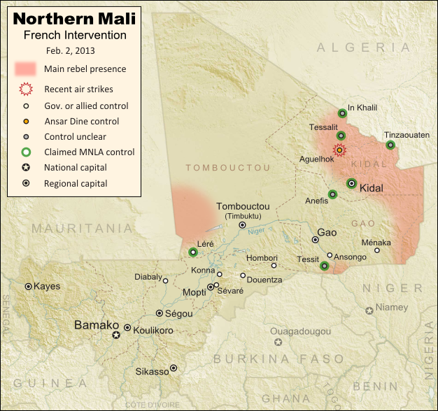
Updated map of fighting and territorial control in Mali during the January-February 2013 French intervention against the Islamist extremist rebel groups Ansar Dine and MUJAO. Reflects the situation as of February 2, when Kidal and other towns have been captured by French and African forces.
Updated map of territorial control and airstrikes in Mali, as of Feb. 2, 2013. Map by Evan Centanni, modified from Wikimedia map by Orionist, using images by Carport and NordNordWest (source). License: CC BY-SA.
French Troops Secure Kidal
After taking the two largest cities in Mali's north over the last week, the French military by Thursday had also secured Kidal, the last of the area's three major regional centers. The religious extremist rebels of Ansar Dine had apparently already fled the city, which was instead occupied by two moderate rebel organizations, the MIA and the MNLA, the latter of which originally took over the north last spring before being driven out by religious extremist groups.

Sunday, January 27, 2013

Mali Conflict Map: Gao and Timbuktu Retaken (January 2013)

There are newer versions of this map available. To see them, view all Mali maps.   

This is an update of our Mali conflict map - for the original story, see Mali Map: Islamist Control & French Intervention.

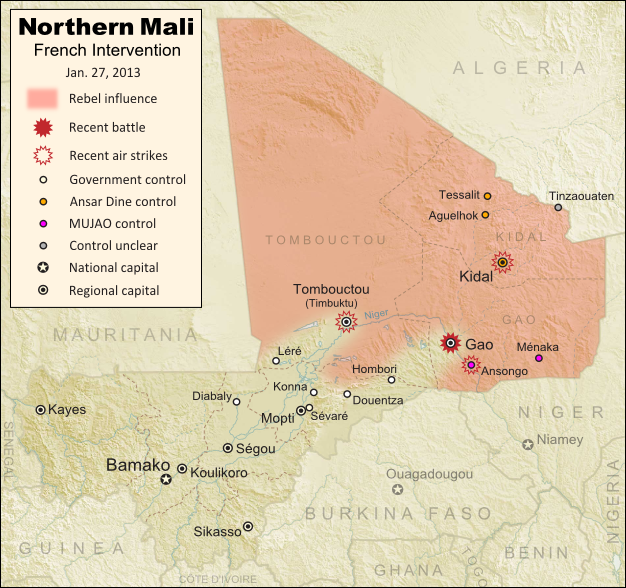
Updated map of fighting and territorial control in Mali during the January 2013 French intervention against the Islamist forces of Ansar Dine and MUJAO. Reflects the Jan. 26-27 recapture of major northern cities Gao and Timbuktu by French and Malian forces.
Updated map of territorial control and fighting in Mali, as of Jan. 27, 2013. Map by Evan Centanni, modified from Wikimedia map by Orionist, using images by Carport and NordNordWest (source). License: CC BY-SA.
French-Malian troops capture two major northern cities
Events have proceeded quickly in Mali's ongoing war since the France's military intervention against radical Islamist rebels began just over two weeks ago. This weekend, French and Malian troops recaptured Gao and Timbuktu, two of the three major towns seized by separatist rebels last spring and taken over by radical right-wing militias a few months later.

Tuesday, January 22, 2013

Mali Conflict Map: Douentza Secured by Government (January 2013)

There are newer versions of this map available. To see them, view all Mali maps.   

This is an update of last week's Mali conflict map - for the full story, see Mali Map: Islamist Control & French Intervention.

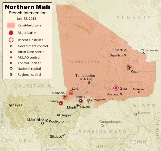
Updated map of fighting and territorial control in Mali during the January 2013 French intervention against the Islamist forces of Ansar Dine and MUJAO. Reflects the Jan. 21 recapture of central town Douentza by French and Malian forces.
Updated map of territorial control and fighting in Mali, as of Jan. 22, 2013. Map by Evan Centanni, modified from Wikimedia map by Orionist, using images by Carport and NordNordWest (source). License: CC BY-SA.
Key Central Town under French-Malian control
The ongoing French-led war against right-wing Islamic insurgents in northern Mali has achieved another victory. Douentza, probably the most important of the central Malian towns formerly held by the rebels, has now been secured by government and French forces. The allied troops reportedly found that the rebels had already left ahead of them, presumably fleeing the French airstrikes that targeted the town over the last week.

Friday, January 18, 2013

Mali Conflict Map: Hardline Rebels Lose Two Towns (January 2013)

There are newer versions of this map available. To see them, view all Mali maps.   

This is an update of yesterday's Mali conflict map - for the full story, see Mali Map: Islamist Control & French Intervention.

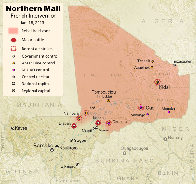
Updated map of fighting and territorial control in Mali during the January 2013 French intervention against the Islamist forces of Ansar Dine and MUJAO. Reflects the Jan. 18 recapture of Konna and Diabaly towns by French and Malian forces.
Updated map of territorial control and fighting in Mali, as of Jan. 18, 2013. Map by Evan Centanni, modified from Wikimedia map by Orionist, using images by Carport and NordNordWest (source). License: CC BY-SA.
Rebels Lose 2 Towns to French-Malian Forces
The French intervention in Mali has finally resulted in territorial gains for the government, after the two central towns of Konna and Diabaly were reportedly retaken by French and Malian troops today. Mali had incorrectly claimed the recapture of Konna earlier this week, and Diabaly was actually seized by the Islamic extremist rebels after French forces arrived. Local sources have now confirmed both towns to be under government control.

Also today, troops from a Nigerian-led West African force finally began arriving in the country (though they have not yet joined in the combat). Meanwhile, a hostage crisis continued into its third day in neighboring Algeria, where militants closely linked to Al Qaeda have taken over a natural gas field and captured its crew of international workers. By some accounts the militants have demanded an end to the French intervention in Mali, though the location of the gas field is far from Mali's borders, and they are believed to have attacked from within Algeria.

Full Story: Mali Map: Islamist Control & French Intervention

Thursday, January 17, 2013

Mali Conflict Map: France Begins Intervention Against Religious Hardline Rebels (January 2013)

There are newer versions of this map available. To see them, view all Mali maps.   

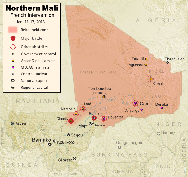
Islamic extremist militants have ruled Mali's vast northern region almost unopposed for half a year, after driving out the secular Tuareg-majority separatists who briefly declared an independent country there last spring. But everything changed last weekend, with a new rebel offensive and surprise French military intervention that have kicked the war back into full gear. Read on for a summary of events.

Map of fighting and territorial control in Mali during the January 2013 French intervention against the Islamist forces of Ansar Dine and MUJAO
Current territorial control and fighting in Mali (including French intervention). Map by Evan Centanni, modified from Wikimedia map by Orionist, using images by Carport and NordNordWest (source). License: CC BY-SA.
Map Updates: Check our Mali channel for frequent updates to this map.

Northern Mali in Rebel Hands
The rebellion in northern Mali began as a separatist struggle led by the National Movement for the Liberation of Azawad (MNLA), a secular group of mostly Tuareg ethnicity who last spring successfully seized Mali's north and declared independence as the State of Azawad. But their victory was soon hijacked by Ansar Dine, a hard-line Islamist militia (also led by Tuaregs) that had fought alongside them previously. Ansar Dine was then joined by MUJAO, an Al Qaeda offshoot group, who swiftly expelled the MNLA from the region. (See: Independent Azawad No More: Northern Mali in Islamist Hands)

Thursday, January 10, 2013

Central African Republic: Map of Rebel Control (January 2013)

Last month, rebels in the Central African Republic launched a sudden military campaign against the government, rapidly taking over city after city in their advance towards the capital. Fighting has now come to a temporary halt, with much of the country under rebel control. Read on for a summary of the conflict so far. 

Map of 2012-2013 rebellion in the Central African Republic, showing current rebel control as of January 11, 2013
Advance of Séléka rebels in the Central African Republic during December 2012 and January 2013. Map fact-checked and modified by Evan Centanni from this map by Wikimedia user Keitsist. License: CC BY-SA
Updated Map: Central African Republic - Map of Rebel Control (March 2013)

Rebellion in the Central African Republic
In 2007, a three-year civil war came to an end in the Central African Republic (CAR) when the government reached a peace agreement with several rebel groups. Yet six years later, some of the rebels feel that the government has still not honored its side of that agreement, and last month violence broke out once again.

The new fighting was initiated by a coalition of rebel groups calling itself "Séléka", which means "alliance" in Sango, the national language of the CAR. The rebels have threatened to depose President François Bozizé, who took power in a 2003 coup but has since won two controversial elections.

Thursday, December 13, 2012

Somalia: Al Shabaab Map Update (Dec. 2012)

There are newer versions of this map available. To see them, view all Somalia articles on PolGeoNow.

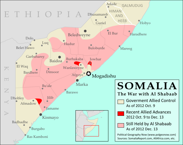
Al Shabaab, Somalia's local branch of Al Qaeda, has continued to gradually lose territory since government-allied forces captured its main stronghold two months ago. As a follow-up to our October feature on the two-year retreat of Al Shabaab, we now present the latest changes to the map of control in southern Somalia.

Map of Al Shabaab control in southern Somalia as of December 2012, highlighting recent advances by government and African Union troops since the capture of key port city Kismayo. Includes the December capture of Jowhar by Ugandan AU forces.
Southern Somalia: recent government-allied advances against Al Shabaab. Original map by Evan Centanni. Incorporates elements from this blank map by Eric Gaba and this locator map by TheEmirr. (license: CC BY-SA).


Slow Progress Against Al Shabaab
Somalia's Islamic extremist militia, Al Shabaab, was greatly weakened when its biggest port and de facto capital of Kismayo was taken by government-allied African Union (AU) forces in October (See: The Retreat of Al Shabaab). However, it still controls a significant amount of territory, and the Somali and AU forces' advance has been slow, with their first major territorial gain acheived only this past weekend.

Tuesday, October 9, 2012

Somalia: The Retreat of Al Shabaab

There are newer versions of this map available. To see them, view all Somalia articles on PolGeoNow. 


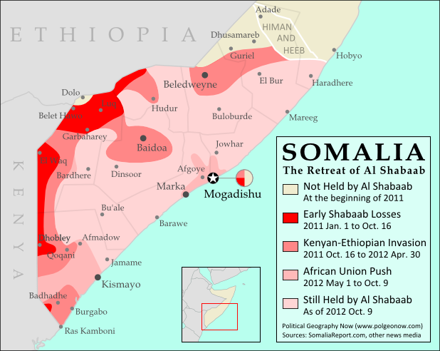
One year ago, Kenya and Ethiopia invaded Somalia to end the rule of Al Shabaab, an Al Qaeda allied extremist group which had taken over the southern half of the country. This map and article are your guide to the militants' slow but steady retreat, culminating in last week's capture of the port city of Kismayo.

Map of the retreat of Al Shabaab Islamist militants in Somalia since 2011, culminating in the October 2012 capture of the key port city of Kismayo. Shows successive stages of advance by Kenyan, Ethiopian, and local forces.
The retreat of the Al Shabaab Islamist militant group in Somalia since 2011. Original map by Evan Centanni. Incorporates elements from this blank map by Eric Gaba and this locator map by TheEmirr. (license: CC BY-SA).

State of Anarchy
Located at the tip of East Africa's "Horn", Somalia has been wracked by chaos and violence since the fall of its last effective national government in 1991. While the northern Somaliland and Puntland regions formed autonomous governments, central and southern Somalia were ruled for many years by a patchwork of local warlords.

Friday, September 14, 2012

Malawi's Flag Change

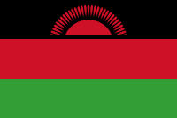
New and old flags of Malawi
Malawi's original rising-sun flag (left) is being re-adopted, after being controversially replaced two years ago by the full-sun banner (right). Graphics are in the public domain (left source; right source).
Just two years after adopting a new flag, the southeast African country of Malawi is changing back to the old one. The original banner, in place from independence in 1964 until its replacement in 2010, was voted back in by the national parliament on May 28, 2012.

Flag of Malawi Country Name:  
• Malawi (English)
• Malaŵi (Chichewa)
Official Name:  
• Republic of Malawi (English)
• Dziko la Malaŵi (Chichewa) 
Capital: Lilongwe
The independence flag, which displays a rising sun to represent the dawn of hope for Africa, was controversially replaced by President Bingu wa Mutharika two years ago. The colors were shuffled around to more closely match the Pan-African Flag, and the red rising sun was changed to a full white sun to symbolize the progress made by Malawi since independence.

When President Mutharika died last April, the Malawian government wasted little time in reverting the unpopular flag change. The move was supported by newly sworn-in President Joyce Banda, who had recently experienced a falling-out with Mutharika and started a new political party.

Although the flag change vote passed in parliament, it is still unclear whether it has passed officially into law via the required presidential signature. In any case though, the rising-sun flag appears to be widely in use again, being flown in the Olympics and displayed on many official websites (except for the main government homepage).

Thursday, September 6, 2012

Independent Azawad No More: Northern Mali in Islamist Hands

There are newer versions of this map available. To see them, view all Mali maps.   

Since declaring the independence of Azawad in April, control by northern Mali's MNLA rebels has been usurped by the hardline Islamists of Ansar Dine and MUJAO. The new regime, while still bitter enemies of the Malian government, does not claim independence. Presented here is a map and brief guide explaining the current situation.

Map of Islamist rebel control in northern Mali as of September 2012
Area held by Islamist rebel groups Ansar Dine and MUJWA in northern Mali. Map by Evan Centanni, modified from Wikimedia map by Orionist, using images by Carport and NordNordWest (source). License: CC BY-SA.
Separatists vs. Islamists
Last April, the Tuareg-dominated separatists of the National Movement for the Liberation of Azawad (MNLA) swept into victory in northern Mali, completing their control of the region and declaring independence as the State of Azawad. But their victory was won only with the support of Ansar Dine, an Islamist militia led by veteran Tuareg fighter Iyad Ag Ghaly. The MNLA and Ansar Dine then alternated between cooperation and conflict for months, with the Islamists grabbing ever more control of the region's cities.

Thursday, June 21, 2012

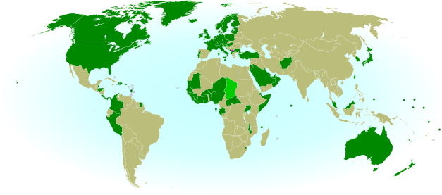
Kosovo Recognized by Chad (Total: 91/193)

Map of countries that recognize the Republic of Kosovo as independent, updated for June 2012
Countries recognizing the Republic of Kosovo in green, with the most recent, Chad, in lighter green (click to enlarge). Kosovo in magenta. Map by Evan Centanni, modified from public domain wiki map (source).

Friday, May 25, 2012

Map: Sudan & South Sudan's Disputed Territories

Countries: South Sudan, Sudan
Official Names: Republic of South Sudan, Republic of Sudan
Summary: After South Sudan declared independence from Sudan last year, much of the border between the neighbors is still hotly disputed, with recent violent clashes around the Heglig oil field and other areas. Read on for a full list of Sudan and South Sudan's eight major border flashpoints.

Map of the border between Sudan and South Sudan, marking selected territorial disputes and border clashes in 2012. Includes inset map of April fighting in region of Heglig oil field.
Border map of Sudan and South Sudan, showing disputed areas and fighting since the beginning of 2012. Aerial bombings and attacks by rebel groups not shown. My own work, using blank Sudan and South Sudan maps by NordNordWest / Wikipedia. License: CC BY-SA.


Friday, April 6, 2012

Declaration of Independence of Azawad (English Translation)

Country Name: Azawad (English, Tuareg, French), Azawād (Arabic)
News Categories: New Countries, Breakaway States, Unrecognized States
Full Story: New Country: Azawad Declares Independence from Mali

Flag of Azawad (image by Orionist; source)
Presented here is the full text of the Declaration of Independence of Azawad, originally posted in French to the website of the National Movement for the Liberation of Azawad (MNLA) on April 6, 2012, and translated into English by Evan Centanni of Political Geography Now. The MNLA is a Tuareg-led rebel group which has recently achieved control of the northern part of Mali in West Africa. For a history of the 2012 Tuareg rebellion in Mali, view all Mali posts on Political Geography Now.

New Country: Azawad Declares Independence From Mali

Country Name: Azawad (English, Tuareg, French), Azawād (Arabic)
News Categories: New Countries, Breakaway States, Unrecognized States
Summary: Tuareg-led rebels in northern Mali have declared "the independent state of Azawad", after taking control of all of the region's major cities and military bases and advancing to near the edge of their claimed territory. Azawad is not recognized as an independent country by any U.N. members, making it an example of a so-called "breakaway state".

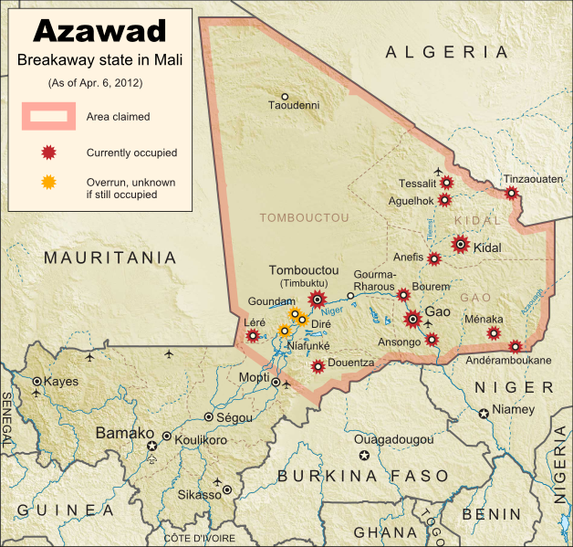
Map of the new independent state of Azawad, declared by MNLA Tuareg rebels in northern Mali. Shows claimed territory and towns controlled by the rebels group as of April 6, 2012
Map of State of Azawad, declared by the Tuareg-majority MNLA rebel group in Mali. Modified from Wikimedia map by Orionist, incorporating images by Carport and NordNordWest (source). License: CC BY-SA.
See Also: Mali Divided by Separatist Fighting; all Mali map updates

MNLA Claims Independent Azawad
The National Movement for the Liberation of Azawad (MNLA) today declared independence from Mali via a statement in French on its website. The rebels of the MNLA, mostly from the Tuareg ethnic group of the Sahara Desert, claim that the northern region of Mali, which they call Azawad, was wrongly included in that country when it declared its independence from France in 1960. There has not yet been any announcement on what form of government Azawad will have, or on which city will be its capital, but the MNLA says it is committed to democracy, to following the rules of the U.N., and to respecting the borders of other countries in the region.

Full Text: Declaration of Independence of Azawad (English Translation)

Flag of the independent state of Azawad, as claimed by the MNLA Tuareg rebel group in northern Mali
Flag of Azawad (image by Orionist; source)
The breakaway state of Azawad is not yet recognized diplomatically by any of the world's other countries, and is unlikely to be any time soon. It joins the ranks of the various wholly or partially unrecognized states of the world, including fellow African state Somaliland, which similarly controls its whole territory despite complete lack of recognition from either the U.N. or other states. This status will likely prevent Azawad from appearing on mainstream world maps for some time to come.
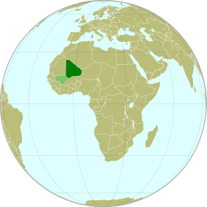
Map showing the location of the new state of Azawad in Africa, declared by the MNLA Tuareg rebel group in northern Mali
Azawad (dark green) and remainder of Mali (light green) in
Africa. Modified from this Wikimedia map (public domain).
Update on Territorial Control
Since our last map update, the Tuareg rebels of the MNLA advanced as far as the town of Douentza (according to their own claims, which have not been disputed), after which they declared a ceasefire, saying they had completed their mission to liberate Azawad. The town of Niafunké has also apparently switched hands a few times over the last few months (source in French), with its current situation unclear. The reality is that the Malian military probably no longer controls anything within the claimed territory of Azawad. Towns not shown as rebel-controlled on the map may simply not be occupied by anyone.

However, the new state of Azawad now faces a threat from another direction - the Islamist Ansar Dine militia, which fought alongside the MNLA over the last few months (with or without their approval). Ansar Dine is now attempting to install strict Sharia (Islamic law) in the cities, in opposition to the MNLA's claimed desire for a secular state. An additional complication is that Ansar Dine in fact does not support independence for Azawad, believing instead that Sharia law should be instated throughout Mali. Ansar Dine is also a Tuareg-led group.

Seen this Mali conflict map on Wikipedia?
While Political Geography Now sometimes uses free maps from Wikipedia or other sites (after double-checking their sources), we also occasionally post our own maps to Wikipedia and Wikimedia Commons for others to use. The first version of this particular map of the Tuareg-led rebellion in Mali was created for Wikipedia by Orionist, but I have since taken charge of keeping it updated, with a bit of help from Mnmazur on Wikimedia Commons (Mnmazur is not associated with Political Geography Now).