Tuesday, June 25, 2013

Syria Civil War Map: June 2013 (#10)

There are newer versions of this map available. To see them, view all Syria updates.

Since March, large-scale violence has continued in Syria. Despite this, no major cities have changed hands - yet there have been important changes to control of smaller towns in two different regions. Here's the updated conflict map, plus a summary of recent territorial changes.

Map of rebel activity and control in Syria's Civil War (Free Syrian Army, Kurdish groups, Al-Nusra Front and others), updated for June 2013. Includes recent locations of conflict and violence, including the Qusayr, Golan Heights, Daraa, Dael, and Baida.
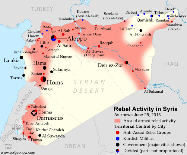
Activity and cities held by rebels and other groups in Syria, updated for June 2013. Map by Evan Centanni, starting from this blank map by German Wikipedia user NordNordWest. License: CC BY-SA

Tuesday, June 11, 2013

Disputed Territory: The Senkaku/Diaoyu Islands

You may have heard the news about China and Japan's ongoing territorial dispute over a group of islands in the East China Sea. But what are the Senkaku/Diaoyu Islands, and why are they so fiercely contested? Read on for all these answers and more!

Map of the Senkaku/Diaoyu Islands, disputed between Japan, China, and Taiwan; includes location as well as detail of islands
Map of the disputed Senkaku/Diaoyu Islands (by Evan Centanni).
Article by Omar Alkhalili

About the Islands
The Senkaku/Diaoyu Islands are a collection of five small islets and three rocks in the East China Sea, all of which are uninhabited. The largest of the islands has an area of 4.32 km² and the smallest is only 0.45 km². They are located about 140 km from the nearest inhabited Japanese islands, 300 km from mainland China and 170 km from Taiwan. They are administered by Japan but claimed by both the People’s Republic of China (PRC) and Taiwan, whose government is known officially as the Republic of China (ROC).

Thursday, May 30, 2013

War in Somalia: Map of Al Shabaab Control (June 2013)

There are newer versions of this map available. To see them, view all Somalia articles on PolGeoNow.

Since the beginning of the year, Somalia's federal government and its allies have made some major breakthroughs in the war to take back the country from Al Shabaab, Somalia's local branch of Al Qaeda. This is the third installment in our series of Al Shabaab control maps, marking territorial changes since our last Somalia map update in December 2012.

Map of Al Shabaab control in southern Somalia just before June 2013, highlighting recent advances by government and African Union troops since December. Includes the newly recaptured Mogadishu-Baidoa highway corridor, plus Bulo Marer, site of crashed U.S. drone aircraft. Also marks claimed territory of Jubaland state.
Southern Somalia: recent government-allied advances in the war against Al Shabaab. Original map by Evan Centanni. Incorporates elements from this blank map by Eric Gaba and this locator map by TheEmirr. (license: CC BY-SA).

Connecting Mogadishu and Baidoa
After news came in of the Somali Federal Government and its allies completing their control of southern Somalia's major cities last fall, further progress against the Al Qaeda affiliate group Al Shabaab at first made only slow progress. But since the beginning of this year, at least one major breakthrough has been made.

Thursday, May 23, 2013

Nigeria Conflict Map: Assault on Boko Haram

There are newer versions of this map available. To see them, view all Nigeria updates.

Nigeria's Boko Haram rebels have been active for some years, but it's only in recent months that they've become known to control territory in the country's far northeast. Now they're facing a full-on assault from the government after the president declared a state of emergency. Read on for details!
Map of Boko Haram control in northeastern Nigeria, and progress made by the government after declaring a state of emergency and launching a military campaign against the rebels in May 2013.
Boko Haram control and the government intervention in Nigeria's northeast. Map by Evan Centanni.

Thursday, May 9, 2013

Who Recognizes Palestine in 2013?

(Keep up with changes to Palestine's situation: view all Palestine updates.)

 Palestine is now an Observer State in the U.N., but it's still not recognized individually by all U.N. member countries. Read on for more about the latest countries to recognize Palestine, plus other recent changes to its international status.
Map of countries that recognize the State of Palestine as an independent country, updated for May 2013 with most recent additions highlighted
Countries recognizing the State of Palestine in green, with most recent additions highlighted in lighter green. Palestine in magenta (circled). Map by Evan Centanni, modified from public domain graphic (source).