Tuesday, October 23, 2012

Syria Uprising Map: October 2012 (#7)

There are newer versions of this map available. To see them, view all Syria updates.

Syria's civil war has raged on over the last two months, with neither side gaining the upper hand. Death and destruction has been enormous, and territorial changes few, though not none. Read on for the rundown.

Map of rebel activity and control in Syria's Civil War (Free Syrian Army, Kurdish groups, and others), updated for October 2012
Activity and cities held by rebels and other groups in Syria, updated for October 2012. Map by Evan Centanni, starting from this blank map by German Wikipedia user NordNordWest. License: CC BY-SA

Thursday, October 18, 2012

Kosovo Recognized by Papua New Guinea (92/193)

Map of countries that recognize the Republic of Kosovo as independent, updated for Papua New Guinea's recognition in October 2012
Countries recognizing the Republic of Kosovo in green, with the most recent, Papua New Guinea (lower right), in lighter green. Kosovo in magenta. Map by Evan Centanni, modified from public domain graphic (source).

Tuesday, October 9, 2012

Somalia: The Retreat of Al Shabaab

There are newer versions of this map available. To see them, view all Somalia articles on PolGeoNow. 


One year ago, Kenya and Ethiopia invaded Somalia to end the rule of Al Shabaab, an Al Qaeda allied extremist group which had taken over the southern half of the country. This map and article are your guide to the militants' slow but steady retreat, culminating in last week's capture of the port city of Kismayo.

Map of the retreat of Al Shabaab Islamist militants in Somalia since 2011, culminating in the October 2012 capture of the key port city of Kismayo. Shows successive stages of advance by Kenyan, Ethiopian, and local forces.
The retreat of the Al Shabaab Islamist militant group in Somalia since 2011. Original map by Evan Centanni. Incorporates elements from this blank map by Eric Gaba and this locator map by TheEmirr. (license: CC BY-SA).

State of Anarchy
Located at the tip of East Africa's "Horn", Somalia has been wracked by chaos and violence since the fall of its last effective national government in 1991. While the northern Somaliland and Puntland regions formed autonomous governments, central and southern Somalia were ruled for many years by a patchwork of local warlords.

Friday, September 21, 2012

Yemen Conflict Map: September 2012 (#4)

Since June, the Yemeni government has completed its campaign to free the south from Al Qaeda rule, but multiple rebel movements remain active. Keep reading for a summary of the current situation. (To see other maps in this series, view all Yemen updates.)

Map of current division in Yemen, including Al Qaeda or Ansar al-Sharia activity, Houthi rebel control, and the location of the Southern Movement insurgency. Update for September 2012.
Presence of rebel forces in Yemen as of September 2012. Ansar al-Sharia is part of Al-Qaeda in the Arabian Peninsula (AQAP). Map by Evan Centanni, using this blank map by NordNordWest/Wikipedia (license: CC BY-SA).


Friday, September 14, 2012

Malawi's Flag Change

New and old flags of Malawi
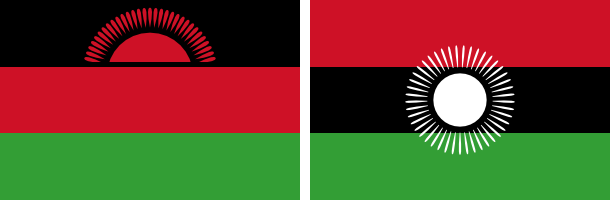
Malawi's original rising-sun flag (left) is being re-adopted, after being controversially replaced two years ago by the full-sun banner (right). Graphics are in the public domain (left source; right source).
Just two years after adopting a new flag, the southeast African country of Malawi is changing back to the old one. The original banner, in place from independence in 1964 until its replacement in 2010, was voted back in by the national parliament on May 28, 2012.

Flag of Malawi Country Name:  
• Malawi (English)
• Malaŵi (Chichewa)
Official Name:  
• Republic of Malawi (English)
• Dziko la Malaŵi (Chichewa) 
Capital: Lilongwe
The independence flag, which displays a rising sun to represent the dawn of hope for Africa, was controversially replaced by President Bingu wa Mutharika two years ago. The colors were shuffled around to more closely match the Pan-African Flag, and the red rising sun was changed to a full white sun to symbolize the progress made by Malawi since independence.

When President Mutharika died last April, the Malawian government wasted little time in reverting the unpopular flag change. The move was supported by newly sworn-in President Joyce Banda, who had recently experienced a falling-out with Mutharika and started a new political party.

Although the flag change vote passed in parliament, it is still unclear whether it has passed officially into law via the required presidential signature. In any case though, the rising-sun flag appears to be widely in use again, being flown in the Olympics and displayed on many official websites (except for the main government homepage).

Thursday, September 6, 2012

Independent Azawad No More: Northern Mali in Islamist Hands

There are newer versions of this map available. To see them, view all Mali maps.   

Since declaring the independence of Azawad in April, control by northern Mali's MNLA rebels has been usurped by the hardline Islamists of Ansar Dine and MUJAO. The new regime, while still bitter enemies of the Malian government, does not claim independence. Presented here is a map and brief guide explaining the current situation.

Map of Islamist rebel control in northern Mali as of September 2012
Area held by Islamist rebel groups Ansar Dine and MUJWA in northern Mali. Map by Evan Centanni, modified from Wikimedia map by Orionist, using images by Carport and NordNordWest (source). License: CC BY-SA.
Separatists vs. Islamists
Last April, the Tuareg-dominated separatists of the National Movement for the Liberation of Azawad (MNLA) swept into victory in northern Mali, completing their control of the region and declaring independence as the State of Azawad. But their victory was won only with the support of Ansar Dine, an Islamist militia led by veteran Tuareg fighter Iyad Ag Ghaly. The MNLA and Ansar Dine then alternated between cooperation and conflict for months, with the Islamists grabbing ever more control of the region's cities.

Thursday, August 16, 2012

Syrian Uprising Map: August 2012 (#6)

There are newer versions of this map available. To see them, view all Syria updates.

Political Geography Now presents the sixth update to our map of rebel control in Syria's civil war. Since last month, battle has erupted in the country's largest city, Kurds have formed a parallel government in northern towns, and more. Read on for a rundown of recent events.

Map of rebel control in Syria's Civil War (Free Syrian Army, Kurdish groups, and others), updated for August 2012
Activity and cities held by rebels and Kurdish groups in Syria, updated August 16, 2012. Map by Evan Centanni, starting from this blank map by German Wikipedia user NordNordWest. License: CC BY-SA

Tuesday, July 31, 2012

Venezuela Joins Mercosur, Paraguay Suspended

Map of intergovernmental organizations in South America: Mercosur, the Andean Community, and UNASUR (Venezuela and Paraguy indicated)
South America's intergovernmental organizations: Mercosur in green, the Andean Community (CAN) in (orange), and remaining members of UNASUR in blue (claimed territorial extents). Map by Evan Centanni, based on this map by Wikimedia user Luan.
After over six years of waiting, Venezuela today officially joined Mercosur (the "Southern Common Market"), one of South America's two main trade blocs.

The country was previously part of the continent's other major bloc, the Andean Community (CAN), but left that organization last year in anticipation of the switch to Mercosur (see Venezuela Leaves Andean Community).

By the time the Venezuela left CAN last year, its application had finally been approved by all Mercosur member states except for Paraguay; but despite support from that country's president, an opposition party in its congress continued to block Venezuela's entry into the trade organization.

Thursday, July 26, 2012

London 2012: Which Countries Are (and Aren't) in the Olympics?

This is an older version of our Parade of Nations article. Click here to see the newest edition!

The 2012 Summer Olympics in London begin tomorrow (July 27), and it wouldn't be an Olympic opening ceremony without the Parade of Nations. But how many countries are there in the games, and is everyone included? Read on for an exclusive guide to the roster of Olympic Nations....

World map showing the five continental associations of National Olympic Committees, including all nations eligible for the Olympic games
The five continental associations representing the world's Olympic Nations. Gold: Pan-American Sports Organization; Green: European Olympic Committees; Black: Olympic Council of Asia; Red: Oceania National Olympic Committees; Blue: Association of National Olympic Committees of Africa; Gray: non-member country or territory. Map by Evan Centanni, modified from public domain wiki map (source), and modeled after this Wikipedia map.

Wednesday, July 11, 2012

Syrian Uprising: Map Update 5

There are newer versions of this map available. To see them, view all Syria updates.

Political Geography Now presents an updated map of territorial division in Syria, where escalating violence is now referred to by the U.N. as a full-scale civil war. Read on for a rundown of recent events.
Map of rebel control in Syria's Civil War, updated for July 2012
Activity by rebel groups in Syria, marking areas of armed conflict as well as towns and cities held. Map by Evan Centanni, starting from this blank map by German Wikipedia user NordNordWest. License: CC BY-SA

Thursday, June 21, 2012

Kosovo Recognized by Chad (Total: 91/193)

Map of countries that recognize the Republic of Kosovo as independent, updated for June 2012
Countries recognizing the Republic of Kosovo in green, with the most recent, Chad, in lighter green (click to enlarge). Kosovo in magenta. Map by Evan Centanni, modified from public domain wiki map (source).

Saturday, June 16, 2012

Yemen Conflict: Map Update 3

Fighting between Yemen's transitional government and Al Qaeda branch Ansar al-Sharia reached a climax this week, as government forces captured the militants' strongholds in Abyan province. This article gives a rundown of recent events and the current situation in divided Yemen.

Map of division in Yemen, including control by Al Qaeda or Ansar al-Sharia, the Houthi rebels, and the Southern Movement. Update for June 2012.
Presence of anti-government forces in Yemen in June 2012. Ansar al-Sharia is part of Al-Qaeda in the Arabian Peninsula (AQAP). Map by Evan Centanni, using this blank map by NordNordWest/Wikipedia (license: CC BY-SA).


Friday, June 1, 2012

Syrian Uprising: Update 4

There are newer versions of this map available. To see them, view all Syria updates.

Full Story: See Syria Divided by Armed Conflict

Map of Syria's uprising, marking cities and towns under control of the Free Syrian Army rebels as of June 2, 2012. Includes the site of the recent Houla massacre.
Known areas of armed activity for the rebel "Free Syrian Army" (click to enlarge). My own work, starting from this blank map by NordNordWest. License: CC BY-SA
Wondering what's been going on in Syria since our last map update? There have been few, if any, major changes in territorial control, but here's a brief status update. 

Despite the U.N. brokered ceasefire between the Syrian military and the rebel Free Syrian Army, which was to enter in effect on April 10, armed clashes have continued in many parts of the country, including recent heavy fighting in Rastan. Bloodshed reached a horrific peak a week ago, as over one hundred civilians - nearly half of them children - were massacred in the Houla area of Homs province. Witnesses told the U.N. that the murders were committed by militias loyal to President Assad, though the Syrian government attempted to blame the atrocity on the rebels. In the aftermath, one commander of the Free Syrian Army threatened to call off the ceasefire altogether, which could mean increased fighting in the coming weeks.

Country Name:  
• Syria (English)
• Sūriyya/Sūryā (Arabic)
Official Name:  
• Syrian Arab Republic (English)
• al-Jumhūriyyah al-‘Arabīyah  as-Sūriyyah (Arabic)
Capital: Damascus
Territorial control by the government and rebels has remained mostly the same since April. The only change made to the map is the addition of Houla in red, as at least one source indicates the area was under rebel control both before and after the massacre. Note that the Free Syrian Army is also reported to control much of the northwestern Idlib province outside of the main cities, though the situation is fluid and information is scarce, making it difficult to mark anything definitively on the map. 

Friday, May 25, 2012

Map: Sudan & South Sudan's Disputed Territories

Countries: South Sudan, Sudan
Official Names: Republic of South Sudan, Republic of Sudan
Summary: After South Sudan declared independence from Sudan last year, much of the border between the neighbors is still hotly disputed, with recent violent clashes around the Heglig oil field and other areas. Read on for a full list of Sudan and South Sudan's eight major border flashpoints.

Map of the border between Sudan and South Sudan, marking selected territorial disputes and border clashes in 2012. Includes inset map of April fighting in region of Heglig oil field.
Border map of Sudan and South Sudan, showing disputed areas and fighting since the beginning of 2012. Aerial bombings and attacks by rebel groups not shown. My own work, using blank Sudan and South Sudan maps by NordNordWest / Wikipedia. License: CC BY-SA.