 |
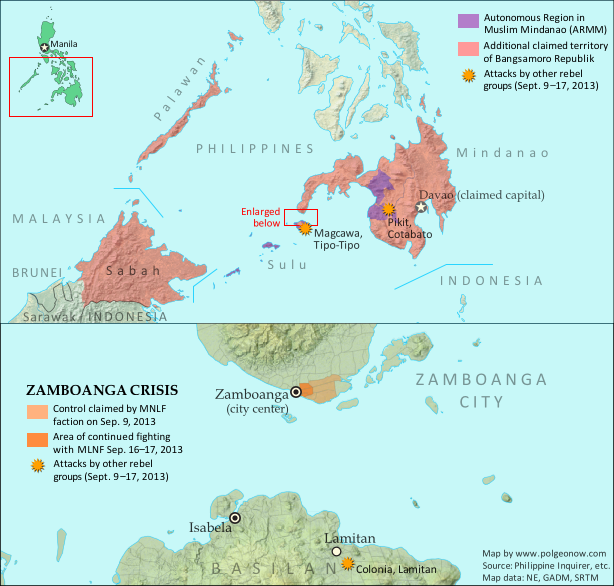
Claims and territorial control of the MNLF rebels/Bangsamoro Republik. Map by Evan Centanni.
|
Updates on the world's countries and borders
Showing posts with label original maps. Show all posts
Showing posts with label original maps. Show all posts
Tuesday, September 17, 2013
Bangsamoro Republik? Philippine Separatists Seize Territory (map)
Zamboanga City in the southwestern Philippines came under rebel attack last week, with insurgents seizing and occupying several neighborhoods. Because the fighters are from a rebel group that declared independence in August, their newfound territorial control might technically be considered the birth of a new breakaway state. Details and discussion below!
Thursday, August 22, 2013
Syria Civil War Map: August 2013 (#11)
There are newer versions of this map available. To see them, view all Syria updates.
Syria's civil war has continued to rage through the summer, with small changes in territorial control and the area of fighting. Here's the updated conflict map, plus a summary of recent territorial changes and other developments.
Syria's civil war has continued to rage through the summer, with small changes in territorial control and the area of fighting. Here's the updated conflict map, plus a summary of recent territorial changes and other developments.
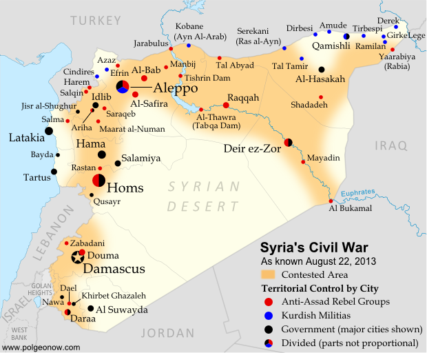 |
Area of fighting and territorial control in Syria's civil war, updated for August 2013. Map by Evan Centanni, starting from this blank map by German Wikipedia user NordNordWest. License: CC BY-SA
|
Saturday, July 20, 2013
Nigeria Map Update: War on Boko Haram Continues After Decline in Rebel Control
There are newer versions of this map available. To see them, view all Nigeria updates.
Two months ago, Political Geography Now published a map of Boko Haram rebel control in Nigeria as the government declared a state of emergency and began a large-scale military intervention. We now present an updated map of the continued fighting and attacks following the rebels' apparent loss of any significant territorial control.
Two months ago, Political Geography Now published a map of Boko Haram rebel control in Nigeria as the government declared a state of emergency and began a large-scale military intervention. We now present an updated map of the continued fighting and attacks following the rebels' apparent loss of any significant territorial control.
 |
Map of fighting and attacks in Nigeria's war against the rebels of Boko Haram. Map by Evan Centanni.
|
Tuesday, July 2, 2013
Croatia Joins EU, leaves CEFTA
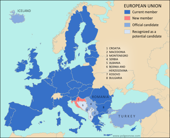 |
| The European Union. Map by Evan Centanni, from this blank map by Ssolbergj. License: CC BY-SA |
Tuesday, June 25, 2013
Syria Civil War Map: June 2013 (#10)
There are newer versions of this map available. To see them, view all Syria updates.
Since March, large-scale violence has continued in Syria. Despite this, no major cities have changed hands - yet there have been important changes to control of smaller towns in two different regions. Here's the updated conflict map, plus a summary of recent territorial changes.
Since March, large-scale violence has continued in Syria. Despite this, no major cities have changed hands - yet there have been important changes to control of smaller towns in two different regions. Here's the updated conflict map, plus a summary of recent territorial changes.
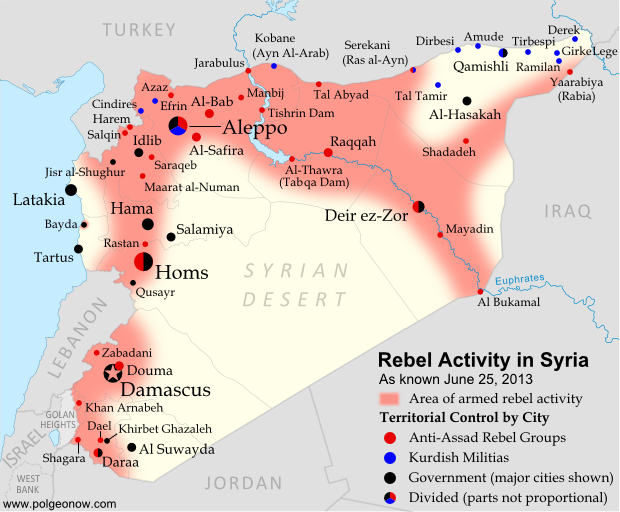 |
Activity and cities held by rebels and other groups in Syria, updated for June 2013. Map by Evan Centanni, starting from this blank map by German Wikipedia user NordNordWest. License: CC BY-SA
|
Tuesday, June 11, 2013
Disputed Territory: The Senkaku/Diaoyu Islands
You may have heard the news about China and Japan's ongoing territorial dispute over a group of islands in the East China Sea. But what are the Senkaku/Diaoyu Islands, and why are they so fiercely contested? Read on for all these answers and more!
Article by Omar Alkhalili
About the Islands
The Senkaku/Diaoyu Islands are a collection of five small islets and three rocks in the East China Sea, all of which are uninhabited. The largest of the islands has an area of 4.32 km² and the smallest is only 0.45 km². They are located about 140 km from the nearest inhabited Japanese islands, 300 km from mainland China and 170 km from Taiwan. They are administered by Japan but claimed by both the People’s Republic of China (PRC) and Taiwan, whose government is known officially as the Republic of China (ROC).
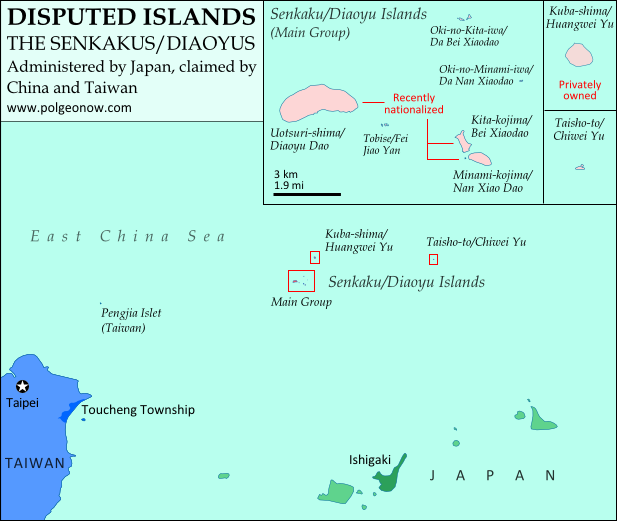 |
Map of the disputed Senkaku/Diaoyu Islands (by Evan Centanni).
|
About the Islands
The Senkaku/Diaoyu Islands are a collection of five small islets and three rocks in the East China Sea, all of which are uninhabited. The largest of the islands has an area of 4.32 km² and the smallest is only 0.45 km². They are located about 140 km from the nearest inhabited Japanese islands, 300 km from mainland China and 170 km from Taiwan. They are administered by Japan but claimed by both the People’s Republic of China (PRC) and Taiwan, whose government is known officially as the Republic of China (ROC).
Thursday, May 30, 2013
War in Somalia: Map of Al Shabaab Control (June 2013)
There are newer versions of this map available. To see them, view all Somalia articles on PolGeoNow.
Since the beginning of the year, Somalia's federal government and its allies have made some major breakthroughs in the war to take back the country from Al Shabaab, Somalia's local branch of Al Qaeda. This is the third installment in our series of Al Shabaab control maps, marking territorial changes since our last Somalia map update in December 2012.
Connecting Mogadishu and Baidoa
After news came in of the Somali Federal Government and its allies completing their control of southern Somalia's major cities last fall, further progress against the Al Qaeda affiliate group Al Shabaab at first made only slow progress. But since the beginning of this year, at least one major breakthrough has been made.
Since the beginning of the year, Somalia's federal government and its allies have made some major breakthroughs in the war to take back the country from Al Shabaab, Somalia's local branch of Al Qaeda. This is the third installment in our series of Al Shabaab control maps, marking territorial changes since our last Somalia map update in December 2012.
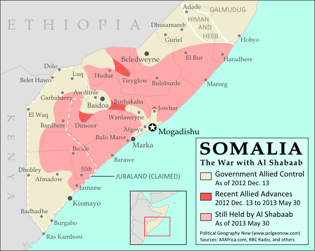 |
| Southern Somalia: recent government-allied advances in the war against Al Shabaab. Original map by Evan Centanni. Incorporates elements from this blank map by Eric Gaba and this locator map by TheEmirr. (license: CC BY-SA). |
Connecting Mogadishu and Baidoa
After news came in of the Somali Federal Government and its allies completing their control of southern Somalia's major cities last fall, further progress against the Al Qaeda affiliate group Al Shabaab at first made only slow progress. But since the beginning of this year, at least one major breakthrough has been made.
Thursday, May 23, 2013
Nigeria Conflict Map: Assault on Boko Haram
There are newer versions of this map available. To see them, view all Nigeria updates.
Nigeria's Boko Haram rebels have been active for some years, but it's only in recent months that they've become known to control territory in the country's far northeast. Now they're facing a full-on assault from the government after the president declared a state of emergency. Read on for details!
Nigeria's Boko Haram rebels have been active for some years, but it's only in recent months that they've become known to control territory in the country's far northeast. Now they're facing a full-on assault from the government after the president declared a state of emergency. Read on for details!
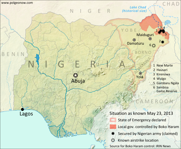 |
Boko Haram control and the government intervention in Nigeria's northeast. Map by Evan Centanni.
|
Thursday, April 25, 2013
Niger and Burkina Faso Resolve Territorial Dispute
Update: In May 2015, Niger and Burkina Faso formally agreed to implement this ICJ ruling, with the practical aspects of exchanging territories to be completed by the end of the following year.
By Evan Centanni
Border Dispute Settled
Last week, a territorial dispute between the West African countries of Niger and Burkina Faso was resolved peacefully with a ruling from the International Court of Justice (ICJ). Both countries' governments agreed to respect the court's ruling on where their border should lie, a question which had persisted ever since they both achieved independence in 1960.
In the ruling, the court drew an official border based on a careful analysis of a 1927 document establishing the pre-independence boundary between the two former French colonies, also turning to a 1960 French map which both countries had agreed to use as a secondary reference. The new border splits the disputed area between Burkina Faso and Niger, and will help put an end to confusion regarding policing and tax collection in the border area.
 |
| Map by Evan Centanni. Sources: ICJ, Natural Earth. Africa inset based on this map by TUBS/Wikimedia Commons (CC BY-SA). |
Border Dispute Settled
Last week, a territorial dispute between the West African countries of Niger and Burkina Faso was resolved peacefully with a ruling from the International Court of Justice (ICJ). Both countries' governments agreed to respect the court's ruling on where their border should lie, a question which had persisted ever since they both achieved independence in 1960.
In the ruling, the court drew an official border based on a careful analysis of a 1927 document establishing the pre-independence boundary between the two former French colonies, also turning to a 1960 French map which both countries had agreed to use as a secondary reference. The new border splits the disputed area between Burkina Faso and Niger, and will help put an end to confusion regarding policing and tax collection in the border area.
Tuesday, March 12, 2013
Map: The Falkland Islands' Disputed Seas
The Falkland Islands, a South Atlantic territory disputed between the U.K. and Argentina, held a status referendum this week in which 99.8% of voters defied Argentina by choosing to remain British. But it's not just about the islands - also at stake are legal rights to the sea for hundreds of miles around.
The Disputed Seas of the Falkland Islands
The Falkland Islands are administered by the U.K. as an overseas territory, but are also claimed based on historical arguments by Argentina, which calls them "las Islas Malvinas". Both countries have signed and ratified the United Nations Convention on the Law of the Sea (UNCLOS), which defines ownership and legal rights for the waters surrounding coastal countries. According to the UNCLOS, each country is entitled to three basic zones of control in its surrounding seas:
 |
Zones of maritime jurisdiction around the Falkland Islands, highlighting area disputed between the U.K and Argentina. Map by Evan Centanni (country coastlines from the Natural Earth dataset). All rights reserved.
|
The Falkland Islands are administered by the U.K. as an overseas territory, but are also claimed based on historical arguments by Argentina, which calls them "las Islas Malvinas". Both countries have signed and ratified the United Nations Convention on the Law of the Sea (UNCLOS), which defines ownership and legal rights for the waters surrounding coastal countries. According to the UNCLOS, each country is entitled to three basic zones of control in its surrounding seas:
Friday, March 8, 2013
Syria Uprising Map: March 2013 (#9)
There are newer versions of this map available. To see them, view all Syria updates.
Syria's civil war has continued to spread eastward across the country, with rebels taking two major towns over the last month. Below is the updated conflict map, plus a summary of recent territorial changes.
Syria's civil war has continued to spread eastward across the country, with rebels taking two major towns over the last month. Below is the updated conflict map, plus a summary of recent territorial changes.
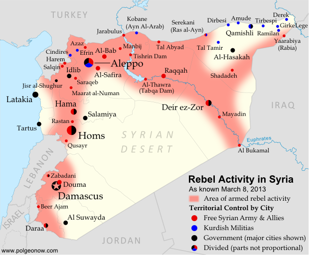 |
Activity and cities held by rebels and other groups in Syria, updated for March 2013. Map by Evan Centanni, starting from this blank map by German Wikipedia user NordNordWest. License: CC BY-SA
|
Wednesday, February 13, 2013
The Political Geography of Chocolate - A Valentine's Day Special
Valentine's Day is just around the corner, and if you thought you were getting a break from geography for sweets and smooching, think again! Political Geography Now presents an introduction to chocolate-based global intergovernmental organizations...
International Chocolate Organizations
You've heard of the U.N., the E.U., and the WTO - but those are only some of the most well-known (i.e. boring!) global intergovernmental organizations. This Valentine's Day, you can take a few minutes to learn about the political geography of chocolate - we'll look at two organizations built around the global trade in cocoa beans, the raw ingredient used in making our favorite sweets.
 |
Map by Evan Centanni, starting from public domain blank world map (source).
|
You've heard of the U.N., the E.U., and the WTO - but those are only some of the most well-known (i.e. boring!) global intergovernmental organizations. This Valentine's Day, you can take a few minutes to learn about the political geography of chocolate - we'll look at two organizations built around the global trade in cocoa beans, the raw ingredient used in making our favorite sweets.
Tuesday, February 5, 2013
Partner Project: Range of Taiwan's Missiles
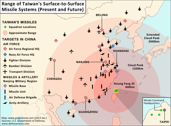 |
| Click to see at full size on Taiwan in Perspective blog. Map by Evan Centanni (all rights reserved). |
If you want to learn more about the complex political situation in Taiwan, Wikipedia has a decent outline of the basics. Political Geography Now also hopes to publish maps and articles covering Taiwan in the future.
Friday, December 28, 2012
Syria Uprising Map: December 2012 (#8)
There are newer versions of this map available. To see them, view all Syria updates.
In recent months, Syria's rebels have continued to tip the balance of the country's civil war toward their favor, with various local victories and a few further extensions of their territorial control. Below is the updated conflict map, plus a summary of recent territorial changes.
In recent months, Syria's rebels have continued to tip the balance of the country's civil war toward their favor, with various local victories and a few further extensions of their territorial control. Below is the updated conflict map, plus a summary of recent territorial changes.
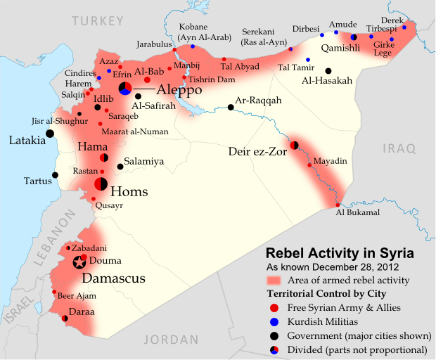 |
Activity and cities held by rebels and other groups in Syria, updated for December 2012. Map by Evan Centanni, starting from this blank map by German Wikipedia user NordNordWest. License: CC BY-SA
|
Thursday, December 13, 2012
Somalia: Al Shabaab Map Update (Dec. 2012)
There are newer versions of this map available. To see them, view all Somalia articles on PolGeoNow.
Al Shabaab, Somalia's local branch of Al Qaeda, has continued to gradually lose territory since government-allied forces captured its main stronghold two months ago. As a follow-up to our October feature on the two-year retreat of Al Shabaab, we now present the latest changes to the map of control in southern Somalia.
Slow Progress Against Al Shabaab
Somalia's Islamic extremist militia, Al Shabaab, was greatly weakened when its biggest port and de facto capital of Kismayo was taken by government-allied African Union (AU) forces in October (See: The Retreat of Al Shabaab). However, it still controls a significant amount of territory, and the Somali and AU forces' advance has been slow, with their first major territorial gain acheived only this past weekend.
Al Shabaab, Somalia's local branch of Al Qaeda, has continued to gradually lose territory since government-allied forces captured its main stronghold two months ago. As a follow-up to our October feature on the two-year retreat of Al Shabaab, we now present the latest changes to the map of control in southern Somalia.
 |
| Southern Somalia: recent government-allied advances against Al Shabaab. Original map by Evan Centanni. Incorporates elements from this blank map by Eric Gaba and this locator map by TheEmirr. (license: CC BY-SA). |
Slow Progress Against Al Shabaab
Somalia's Islamic extremist militia, Al Shabaab, was greatly weakened when its biggest port and de facto capital of Kismayo was taken by government-allied African Union (AU) forces in October (See: The Retreat of Al Shabaab). However, it still controls a significant amount of territory, and the Somali and AU forces' advance has been slow, with their first major territorial gain acheived only this past weekend.
Thursday, December 6, 2012
Is Palestine Really a Country?
(Keep up with changes to Palestine's situation: view all Palestine updates.)
Palestine is now recognized as a country by both the U.N. and a majority of its members, but many have questioned whether this new-found status reflects the truth on the ground. Is Palestine really an independent country, or is this a political fantasy concocted by supporters in the U.N.?
What is a "sovereign state"?
By the most common definition, a "state" has to have:
A prospective country that fits these criteria is described by geographers as a de facto sovereign state, even if it's not recognized by the international community (de facto is Latin for "in actual fact").
Palestine is now recognized as a country by both the U.N. and a majority of its members, but many have questioned whether this new-found status reflects the truth on the ground. Is Palestine really an independent country, or is this a political fantasy concocted by supporters in the U.N.?
 |
| The Olso Accords divided the Palestinian territories into three areas of control (see article for explanation). Map by Evan Centanni. Sources: Natural Earth, B'Tselem, U.N. OCHA oPt. |
By the most common definition, a "state" has to have:
- A government
- A defined territory
- A permanent population
- The ability to conduct foreign relations with other states
A prospective country that fits these criteria is described by geographers as a de facto sovereign state, even if it's not recognized by the international community (de facto is Latin for "in actual fact").
Tuesday, October 23, 2012
Syria Uprising Map: October 2012 (#7)
There are newer versions of this map available. To see them, view all Syria updates.
Syria's civil war has raged on over the last two months, with neither side gaining the upper hand. Death and destruction has been enormous, and territorial changes few, though not none. Read on for the rundown.
Syria's civil war has raged on over the last two months, with neither side gaining the upper hand. Death and destruction has been enormous, and territorial changes few, though not none. Read on for the rundown.
 |
Activity and cities held by rebels and other groups in Syria, updated for October 2012. Map by Evan Centanni, starting from this blank map by German Wikipedia user NordNordWest. License: CC BY-SA
|
Tuesday, October 9, 2012
Somalia: The Retreat of Al Shabaab
There are newer versions of this map available. To see them, view all Somalia articles on PolGeoNow.
One year ago, Kenya and Ethiopia invaded Somalia to end the rule of Al Shabaab, an Al Qaeda allied extremist group which had taken over the southern half of the country. This map and article are your guide to the militants' slow but steady retreat, culminating in last week's capture of the port city of Kismayo.
State of Anarchy
Located at the tip of East Africa's "Horn", Somalia has been wracked by chaos and violence since the fall of its last effective national government in 1991. While the northern Somaliland and Puntland regions formed autonomous governments, central and southern Somalia were ruled for many years by a patchwork of local warlords.
One year ago, Kenya and Ethiopia invaded Somalia to end the rule of Al Shabaab, an Al Qaeda allied extremist group which had taken over the southern half of the country. This map and article are your guide to the militants' slow but steady retreat, culminating in last week's capture of the port city of Kismayo.
 |
| The retreat of the Al Shabaab Islamist militant group in Somalia since 2011. Original map by Evan Centanni. Incorporates elements from this blank map by Eric Gaba and this locator map by TheEmirr. (license: CC BY-SA). |
State of Anarchy
Located at the tip of East Africa's "Horn", Somalia has been wracked by chaos and violence since the fall of its last effective national government in 1991. While the northern Somaliland and Puntland regions formed autonomous governments, central and southern Somalia were ruled for many years by a patchwork of local warlords.
Friday, September 21, 2012
Yemen Conflict Map: September 2012 (#4)
Since June, the Yemeni government has completed its campaign to free the south from Al Qaeda rule, but multiple rebel movements remain active. Keep reading for a summary of the current situation. (To see other maps in this series, view all Yemen updates.)
 |
| Presence of rebel forces in Yemen as of September 2012. Ansar al-Sharia is part of Al-Qaeda in the Arabian Peninsula (AQAP). Map by Evan Centanni, using this blank map by NordNordWest/Wikipedia (license: CC BY-SA). |
Thursday, August 16, 2012
Syrian Uprising Map: August 2012 (#6)
There are newer versions of this map available. To see them, view all Syria updates.
Political Geography Now presents the sixth update to our map of rebel control in Syria's civil war. Since last month, battle has erupted in the country's largest city, Kurds have formed a parallel government in northern towns, and more. Read on for a rundown of recent events.
Political Geography Now presents the sixth update to our map of rebel control in Syria's civil war. Since last month, battle has erupted in the country's largest city, Kurds have formed a parallel government in northern towns, and more. Read on for a rundown of recent events.
 |
Activity and cities held by rebels and Kurdish groups in Syria, updated August 16, 2012. Map by Evan Centanni, starting from this blank map by German Wikipedia user NordNordWest. License: CC BY-SA
|
Subscribe to:
Posts (Atom)