Thursday, June 23, 2016

Brexit: 9 Geography Facts You Should Know About the Referendum and Britain's EU Membership

(Subscribers click here to view this article in the members area.)

By Evan Centanni 

The European Union. Click for full map and list of members.
Today the UK is voting on whether to leave the European Union. If you've been paying attention to the news, you've probably heard about the intense debate over whether Brits should vote "Leave" or "Remain". But if you're like me and mainly in this for the geography trivia, here are some fun facts you might not know about the so-called "Brexit":

Tuesday, June 21, 2016

On the Ground: Gibraltar and the "Brexit" Referendum

This is the first installment of PolGeoNow's On the Ground, a new series of exclusive photo essays on what political geography looks like in the real world. Whether it's borders, nationalism, or other geopolitical phenomena, we'll bring the on-the-ground situations to your screen in vivid detail.

Update 2016-06-24: Gibraltar on Thursday voted in favor of the UK staying in the European Union, by an incredible margin of  96% to 4%. However, the UK as a whole voted to leave the EU, meaning that Gibraltar can expect to get pulled out with it, against the wishes of the Gibraltarians.
 
Photo of the Gibraltar Stronger in Europe campaign office on the British territory's main street. Gibraltar's population is overwhelmingly against a so-called Brexit, or departure of the UK from the European Union.
Subscribers click here to view this article in the ad-free members area. Not a member yet? Learn about PolGeoNow subscriptions!

Map of Gibraltar and its location in Europe relative to the UK and Spain
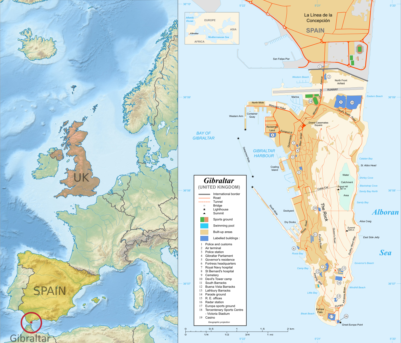
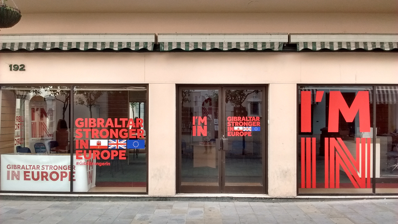
Right: Map of Gibraltar by Eric Gaba (source; CC BY-SA)
Left: Gibraltar's location in Europe (based on this Wikimedia Commons map by TUBS; CC BY-SA)
Gibraltar prepares to vote on whether UK should leave European Union
Last month, PolGeoNow's Evan Centanni and Meihsing Kuo visited the small British territory of Gibraltar (pronounced "jih-BRALL-ter"), one month ahead of the UK's referendum on whether to leave or remain in the European Union (EU).

Gibraltar, a tiny peninsula connected to Spain - and claimed by the Spanish government - is the only British overseas territory that's part of the EU. It's also the only external territory whose residents are eligible to vote in the so-called "Brexit" referendum without living in the UK proper. ("Brexit" is an abbreviation for "British exit" from the EU.)

Wednesday, June 8, 2016

Ukraine War Control Map & Report: June 2016

There are newer versions of this map available. To see them, view all Ukraine updates.

Subscribers click here to view this article in the ad-free members area. Not a member yet? Learn about PolGeoNow subscriptions!
Map of rebel territorial control in Ukraine's eastern provinces of Donetsk and Luhansk, claimed by the breakaway Donetsk People's Republic and Lugansk People's Republic. Updated for June 2016, with Minsk ceasefire lines shown.
Map by Evan Centanni (all rights reserved)
Timeline by Djordje Djukic, with additional reporting by Evan Centanni

Summary of Developments
PolGeoNow's previous Ukraine control map report was published in March of last year, just a month after a ceasefire was implemented under the Minsk II agreement, a hard-won deal between the Kiev government and representatives of the self-proclaimed Donetsk and Lugansk People's Republics (established by rebels with extensive support from the other side of the Russian border). Since then, the ceasefire has broadly held, which explains why the war in eastern Ukraine has largely dropped out of world newspaper front pages. However, fighting has continued off and on at a reduced level, and the ceasefire agreement is still on shaky ground. This map and timeline report describe what has happened over the past year, including some small changes to territorial control.

Thursday, May 19, 2016

Iraq Control Map & Report: May 2016 (Subscription)

MEMBERS CLICK HERE TO PROCEED TO ARTICLE AND MAP

There are newer versions of this map available. To see them, view all Iraq updates.

Research by Djordje Djukic. Map by onestopmap.com, Evan Centanni, and Djordje Djukic

Subscribe for full access to all conflict map reports!

Detailed map of territorial control in Iraq as of May 17, 2016, including territory held by the so-called Islamic State (ISIS, ISIL), the Baghdad government, and the Kurdistan Peshmerga. Includes recent flashpoints such as Rutbah, Doulab, Tuz Khurmatu, and more. The past month has seen several small victories of Iraqi government forces against the so-called "Islamic State" (ISIS/ISIL), as well as a handful of other notable territorial events.
 
See all this and more on the latest update to PolGeoNow's concise, professional map of control in Iraq's civil war, including a timeline of changes since our previous Iraq map report of April 2016.

This map and report are premium professional content, available to paid subscribers of the PolGeoNow Conflict Mapping Service.

Want to see before you subscribe? Check out our most recent FREE SAMPLE Iraq map report!

Exclusive map report includes:
  • New since last year: Terrain shading and major highways included on map for geographic context
  • Up-to-date map of current territorial control in Iraq, color-coded for the Iraqi government, "Islamic State" (ISIS/ISIL) extremists, and Kurdistan's Peshmerga forces
  • Detailed indication of town-by-town control, including provincial boundaries, all major cities, and many smaller ones
  • Markers for key areas of recent fighting such as Rutbah, Doulab, Tuz Khurmatu, and more
  • Timeline of changes to the situation since mid-April, compiled by our Iraq specialist, with links to sources

MEMBERS CLICK HERE TO PROCEED TO ARTICLE AND MAP

Not a member yet? Click here to learn more about our professional subscription service!

Can I purchase just this map?
This map and report are not available for automated purchase to non-subscribers. If you need access or republication rights for only this map report, contact service@polgeonow.com for options.

Sunday, May 15, 2016

Syrian Civil War Control Map & Report: May 2016 (Subscription)

MEMBERS CLICK HERE TO PROCEED TO ARTICLE AND MAP

There are newer versions of this map available. To see them, view all Syria updates.

Research by Djordje Djukic. Map by onestopmap.com, Evan Centanni, and Djordje Djukic

Subscribe for full access to all conflict map reports!

Map of fighting and territorial control in Syria's Civil War (Free Syrian Army rebels, Kurdish YPG, Syrian Democratic Forces (SDF), Al-Nusra Front, Islamic State (ISIS/ISIL), and others), updated for March 2016. Now includes terrain and major roads (highways). Highlights recent locations of conflict and territorial control changes, such as Daraa, Khanaser, Tell Rifaat, Shadadi, the Aleppo Power Plant, and more. 
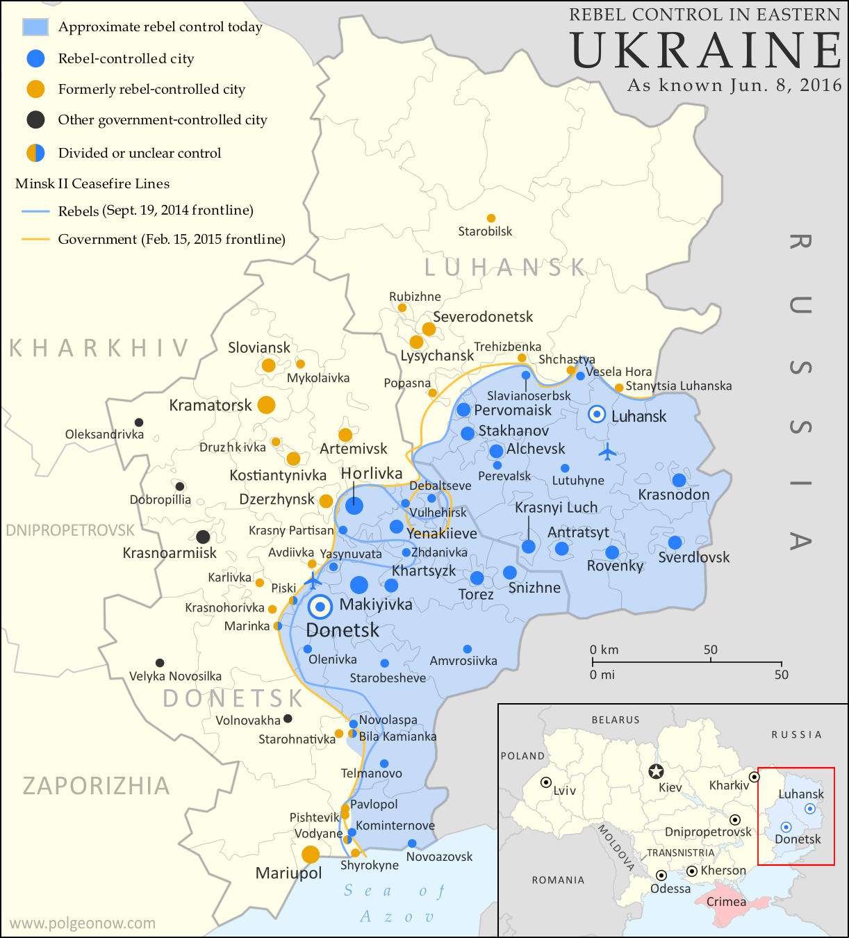
The so-called "Islamic State" (ISIS/ISIL) has lost control of several towns in Syria over the past month and a half, but has also scored some victories. Meanwhile, a partial breakdown in the UN-brokered ceasefire has resulted in resumed fighting between government and rebel forces in the Aleppo area.
 
See all this and more on the latest update to PolGeoNow's concise, professional Syrian Civil War control map, which includes a timeline of changes since our previous Syria map report at the end of March.

This map and report are premium professional content, available to paid subscribers of the PolGeoNow Conflict Mapping Service.

Want to see before you subscribe? Check out our most recent FREE SAMPLE Syria map!

Exclusive map report includes:
  • Up-to-date map of current territorial control in Syria, color-coded for the Assad government, rebel groups, "Islamic State" (ISIS/ISIL) extremists, and Kurdish/SDF forces. 
  • Special symbols indicating towns dominated by rebels of Al Qaeda affiliate Jabhat al-Nusra (the Nusra Front) and by multi-ethnic anti-ISIS Syrian Democratic Forces (SDF).
  • Detailed indication of city-by-city control, highlighting key towns and other locations important to current events.
  • Locations of recent fighting and military operations, including Qaryatain, Al-Rai, Shaer gas field, and more.
  • Detailed timeline of important events and changes to territorial control since March 31, 2016, compiled by our Syria-Iraq expert, with links to sources.

MEMBERS CLICK HERE TO PROCEED TO ARTICLE AND MAP

Not a member yet? Click here to learn more about our professional subscription service!

Can I purchase just this map?
This map and report are not available for automated purchase to non-subscribers. If you need access or republication rights for only this map report, contact service@polgeonow.com for options.