Showing posts with label subdivision changes. Show all posts

Wednesday, March 29, 2023

2022: Donetsk & Lugansk People's Republics Stop Claiming Independence

Most of our readers will already have heard of this story last year, but because PolGeoNow is committed to providing a record of all changes to the world's list of countries, and because this aspect of the story hasn't been much discussed, we're still publishing an article about it now. Parts of this article are adapted from our story on Recognition of the Donetsk and Lugansk People's Republics from one year ago.

Map of territorial control within the claimed borders of the self-declared Donetsk People's Republic (DPR) and Lugansk People's Republic (LPR) as of September 26, 2022, a week before they stopped claiming independence after their claimed merger with Russia (annexation). Map shows that all of the LPR, otherwise known as Ukraine's Luhansk province, was under the control of Russian and LPR forces, while Russian and DPR forces controlled over half of the DPR, or Ukraine's Donetsk province, including the major central and southern cities of Donetsk, Horlivka, Makiyivka, and Mariupol. Colorblind accessible.
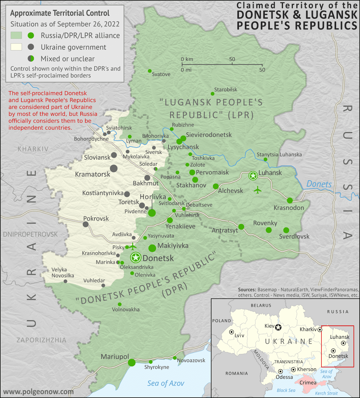
Actual military/administrative control within the DPR and LPR's claimed borders just before their governments' agreed merger into Russia. This was also roughly their greatest extent of control during the period they claimed to be independent countries, if including territory held by their close ally the Russian military. This map was originally published as part of our subscriber-exclusive September 2022 Ukraine control map report.

Partial Recognition

For eight years, from 2014 to 2022, the so-called Donetsk People's Republic (DPR) and Lugansk People's Republic (LPR) said they were independent countries, despite most of the world considering them to be parts of Ukraine. Then late last year, they stopped claiming independence, instead saying they had now become part of Russia, after Russia controversially agreed to take them in. Read on for the full story, explained in plain English...

Wednesday, February 3, 2021

Guest Map: Border Changes in Ethiopia's Tigray Conflict (February 2021)

Update: PolGeoNow now has an in-house map showing territorial control in northern Ethiopia. To find the latest version, view all Ethiopia reports.

For the second time, we're honored to feature a map of the Tigray conflict created by our colleague Daniel from Passport Party. Though detailed territorial control is difficult to map right now, Daniel illustrates how the shakeup has resulted in new de facto courses for both state and national borders in the area.

Tigray border changes map: Illustration of changes to the de facto courses of state and national borers amid Ethiopia's Tigray war, as known January 30, 2021, showing areas taken over by Amhara state and Eritrea. By Daniel of Passport Party.
Map of de facto border changes amid the 2020-2021 Tigray conflict, by Daniel of Passport Party (used with permission).


Ethiopia Conflict: Passport Party's Map of Tigray Border Changes 

Since our previous Tigray conflict article in November, featuring our colleague Daniel's map of territorial control at that time, the war in Ethiopia's Tigray state has cooled down somewhat. Because of the situation on the ground, it's probably not possible to reliably map out the details of territorial control in Tigray right now. So instead, Daniel's new map - originally published on his Passport Party blog and Twitter account - focuses on another interesting aspect of the political geography: the way that overall administrative boundaries have changed during the war, even if not officially.
 

Thursday, October 29, 2020

Puerto Rico: 52nd State of the US? (2020 Referendum - Updated with Results)

In 2012, we reported on Puerto Rico's chances at becoming the a state of the US, after the territory's people sort of voted for that. This is an updated and expanded version of that article, fully revised for next week's new Puerto Rico statehood referendum. 

Continue reading to learn why this time might be different, and why Puerto Rico could become the 52nd state of the US instead of the 51st!

For updates on the results of the referendum, scroll to the bottom of this article.


Puerto Rico Statehood Vote: Different This Time

The US territory of Puerto Rico. (Public domain map from CIA World Factbook)

The US territory of Puerto Rico, made up of one large island and several smaller ones in the Caribbean, doesn't have any say in next week's US presidential election. 

But its people will still have something important to vote on next Tuesday: a referendum on whether to fully join the US as one of the country's states. 

Like in previous votes, the result is non-binding: It can only take effect if approved by the US government. But that doesn't mean it's just a symbolic move.

Sunday, July 5, 2020

US State of Mississippi Now Has No Flag

Update: On November 3, 2020, Mississippi voted to approve a replacement flag, which was then officially adopted on January 11, 2021.


The second flag of the US state of Mississippi, stripped of official status on June 30, 2020
Former official flag of Mississippi state (2001-2020)

The Mississippi Flag is No More

Last Tuesday the elected governor of Mississippi, one of the 50 states of the United States of America, signed a new law stripping official status from the state's controversial flag.

Mississippi's was the only remaining state flag to include the Confederate battle emblem, a symbol of the separatist Confederate States of America who fought to preserve slavery in the country's 1860s civil war.

Though citizens are not banned from flying the flag - a right protected by the US Constitution - it has been taken down from both the state government building and the US Capitol in Washington, DC. Several city governments and universities in Mississippi had already stopped flying the state flag.

Tuesday, November 26, 2019

Ethiopia's Sidama Zone Votes to Become Regional State

Want even more free geography news updates like this one? Help us out by taking a 3-minute survey on our plan to seek funding through optional donations.

Political map of Ethiopia's regional states, highlighting Sidama Zone, which in November 2019 voted to split off from the Southern Nations, Nationalities, and People's Region (SNNPR) to become a new regional state.

Sidama Referendum Passes

Last week, we reported on a status referendum in southern Ethiopia, where the Sidama Zone was voting on whether to secede from the country's Southern Nations, Nationalities, and Peoples' Region (SNNPR).

Over the weekend, the Ethiopian government announced that the referendum had passed by a very large margin: According to preliminary results, an enormous 98.5% of voters chose increased self-rule. (Voter turnout was also reported to be extremely high, at 99.8%.)

Ethiopia's government has signaled that it plans to respect the result, making the Sidama Zone into the country's tenth self-governing "regional state". This comes despite warnings that Sidama's promotion will supercharge campaigns for statehood in other regions, which could lead to a cascade of mini-secessions that would shake up Ethiopia's administrative structure and politics.

But the Sidama Zone won't become a state immediately - there will likely be a long, contentious process, which requires an amendment to Ethiopia's constitution. One major issue is that the SNNPR's capital city, Hawassa, is located inside the Sidama Zone. If it's going to become the capital of the Sidama Region instead, then the SNNPR will have to find a new capital and move all its government institutions there.

Sidama will become the second-smallest of the Ethiopia's regional states, after the Harari People's National Regional State (the cities of Addis Ababa and Dire Dawa aren't considered regional states, even though they stand separately from the other regions). Its promotion will also create a new state-level exclave - a part of a state that's not connected to the rest of the state - by cutting off the Gedeo Zone to its south from the rest of the SNNPR.

Want to know when these changes actually happen? You'll hear about it here on PolGeoNow!

Monday, March 20, 2017

2016 Year in Review: Country & Border Changes

Inside this Review of 2016:

Map of election results from the UK's "Brexit" referendum on leaving the European Union
    • Country name, capital, and flag changes
    • Border changes and disputed territories 
    • Separatist states and proposed new countries
    • Recognition of disputed countries 
    • Countries joining (and leaving) international organizations
    • Sea borders and seabed claims
    • New states and provinces within countries
    • Changes to countries' coastal contours and official languages
        And in companion articles:
        Rebel Control Around the World in 2016 
        Time Zones that Changed in 2016 

        It's PolGeoNow's mission to track changes to the world's countries, borders, and territories, whether it's happening formally on the books or unofficially on the ground. When new countries appear, borders change, and territorial disputes arise or are settled, you'll hear about it here. With 2016 now concluded, here's our look back at the events of the year!

        (For extra coverage of geography events in 2017, follow @PolGeoNow on Twitter!)

        Tuesday, January 19, 2016

        2015: The Year in Political Geography Changes

        Premium members click here to view this article in the ad-free members area. Not a member yet? Learn about PolGeoNow subscriptions!

        Libya control relief map: Shows detailed territorial control in Libya's civil war as of August 2015, including all major parties (Tobruk government, General Haftar's Operation Dignity forces, and Zintan militias; Tripoli GNC government, Libya Dawn, and Libya Shield Force; Shura Council of Benghazi Revolutionaries and other hardline Islamist groups; and the so-called Islamic State). Also file under: Map of Islamic State (ISIS) control in Libya.
        Rival government and "Islamic State" (ISIS) control in Libya, August 2015 (click for free full-size map and article)

        Inside this Review of 2015:

        • New countries, breakaway states, and micronations
        • Country name, capital, and flag changes
        • Border changes and disputed territories
        • Countries joining international organizations
        • Recognition of disputed countries
        • Rebel control in conflict zones
        • Sea borders and seabed claims
        • New states and provinces
        • Currency changes
        • World time zone changes
          It's PolGeoNow's mission to track changes to the world's countries, borders, and territories, whether it's happening formally on the books or unofficially on the ground. When new countries appear, borders change, and territorial disputes arise or are settled, you'll hear about it here. With 2015 now concluded, here's our look back at the events of the year!

          (For extra coverage of political geography events in 2016, follow us on Twitter!)

          Friday, January 23, 2015

          2014: The Year in Political Geography Changes

          Premium members click here to view this article in the ad-free members area. Not a member yet? Subscribe now!

          Map of voting results in Scotland's 2014 independence referendum, modified to show the effects of population differences between Scotland's regions
          Scotland said "NO" to independence in a close vote last September.
          Inside this Review of 2014:
          • New countries & breakaway states
          • Membership in international organizations
          • Recognition of disputed countries
          • Territorial disputes
          • Rebel control
          • Sea borders and seabed claims
          • New states and provinces
          • Changes to world time zones
          • And more!
          PolGeoNow's mission is tracking changes to the world's countries, borders, and territories, whether it's happening formally on the books or unofficially on the ground. When new countries appear, borders change, and territorial disputes arise or are settled, you'll hear about it here. With 2014 now concluded, here's our look back at the major events of the year!

          (Note: For extra coverage of political geography events in 2015, follow us on Twitter!)

          Thursday, March 27, 2014

          Crimea Joins Russia, Gives Up Independence, Becomes Disputed Territory

          Premium members click here to view this article in the ad-free members area. Not a member yet? Subscribe now!

          Map of the claimed Republic of Crimea, which briefly declared independence from Ukraine on Mar. 17 before being annexed by Russia
          The claimed Republic of Crimea which has now joined Russia (click to see full-sized map). By Evan Centanni, based on this blank map.
          By Evan Centanni

          Russia Annexes Crimea
          The Crimean peninsula, which declared independence from Ukraine ten days ago as the Republic of Crimea, has now been absorbed into Russia. This was part of the plan all along - the claimed Republic of Crimea had requested to join Russia at the same time that it declared independence.

          Related: Complete Map of Locations Seized by Russia in Crimea (Premium)

          Tuesday, March 18, 2014

          Crimea Declares Independence: Is It Really a Country?

          On Monday, two regional governments on the Crimean Peninsula controversially declared their independence from Ukraine as the new Republic of Crimea. While the declaration has been rejected by most of the world community, and Crimea hopes to swiftly unite with Russia, for now it might be considered a de facto sovereign state. Read on for details.

          Map of the newly declared independent Republic of Crimea, seceding from Ukraine to join Russia (colorblind accessible).
          The Republic of Crimea. Map by Evan Centanni, based on this blank map.
          Premium members click here to view this article in the ad-free members area. Not a member yet? Subscribe now!

          By Evan Centanni

          Declaration of Independence
          Following Ukraine's revolution, the explosion of pro-Russian protests in the east, and the subsequent occupation of the Crimean peninsula by Russian forces (see our premium report, Ukraine Map: Occupations, Autonomy, & Invasion), a new independent country has been declared on the coast of the Black Sea.

          Tuesday, November 27, 2012

          Puerto Rico: 51st State of the U.S.?

          [This article was written after Puerto Rico's 2012 status referendum. In June 2017, Puerto Rico voted in another controversial referendum, again technically in favor of statehood. Most of this five-year-old article is still accurate after the 2017 vote. -Editor]


          Earlier this month, papers reported that Puerto Rico had voted to become a state of the U.S. - but will it really happen? What does it take to become a state, anyway? Last time, we explained Puerto Rico's current status - now for answers about the territory's future....

          Flag of the United States with a new star added (total of 51 stars) for a hypothetical new state of Puerto Rico
          A possible 51-star U.S. flag. Since each star on the flag represents one state, a new one would need to be added for Puerto Rico (public domain; source).
          Why would Puerto Rico want to become a state?
          Puerto Rico's current situation leaves it disadvantaged compared to the states. It has its own constitution and government, but the laws establishing them are subject to approval by the U.S. Congress. And despite the fact that most federal taxes and other laws apply to Puerto Ricans, residents have no real representation in Congress and no say in the presidential election. (For more details, see What is Puerto Rico?)