Showing posts with label border changes. Show all posts

Wednesday, March 29, 2023

2022: Donetsk & Lugansk People's Republics Stop Claiming Independence

Most of our readers will already have heard of this story last year, but because PolGeoNow is committed to providing a record of all changes to the world's list of countries, and because this aspect of the story hasn't been much discussed, we're still publishing an article about it now. Parts of this article are adapted from our story on Recognition of the Donetsk and Lugansk People's Republics from one year ago.

Map of territorial control within the claimed borders of the self-declared Donetsk People's Republic (DPR) and Lugansk People's Republic (LPR) as of September 26, 2022, a week before they stopped claiming independence after their claimed merger with Russia (annexation). Map shows that all of the LPR, otherwise known as Ukraine's Luhansk province, was under the control of Russian and LPR forces, while Russian and DPR forces controlled over half of the DPR, or Ukraine's Donetsk province, including the major central and southern cities of Donetsk, Horlivka, Makiyivka, and Mariupol. Colorblind accessible.
Actual military/administrative control within the DPR and LPR's claimed borders just before their governments' agreed merger into Russia. This was also roughly their greatest extent of control during the period they claimed to be independent countries, if including territory held by their close ally the Russian military. This map was originally published as part of our subscriber-exclusive September 2022 Ukraine control map report.

Partial Recognition

For eight years, from 2014 to 2022, the so-called Donetsk People's Republic (DPR) and Lugansk People's Republic (LPR) said they were independent countries, despite most of the world considering them to be parts of Ukraine. Then late last year, they stopped claiming independence, instead saying they had now become part of Russia, after Russia controversially agreed to take them in. Read on for the full story, explained in plain English...

Wednesday, October 13, 2021

Somalia v. Kenya: 3 Maps Explaining the Maritime Dispute & Court Ruling

Thumbnail image combining the three maps of the Kenya-Somalia maritime dispute, showing the two countries' overlapping territorial sea, EEZ, and continental shelf claims as well as the judgement reached in the ruling of the UN's International Court of Justice (ICJ). The full-size maps are each included separately, with full alternate text, farther down on this page.
Scroll down for the full-size maps

The UN's main court for disputes between countries, the International Court of Justice (ICJ), ruled yesterday on a contentious case many years in the making: Kenya and Somalia's dispute over the rights to a large slice of the Indian Ocean off their coasts.

While other news outlets analyze the politics and economics of the dispute, it's PolGeoNow's job to give you a clearer, more detailed explanation of its geography. And as shown in the three all-new map infographics below, that geography is a bit more complex than most news articles let on.

Scroll down to see each map at full size, along with concise explanations expanding on the information within the graphics...


Saturday, February 3, 2018

Map: Costa Rica & Nicaragua Settle Border Dispute in Court

Conflicto Isla Portillos - mapa 2018. Map of Costa Rica and Nicaragua's post-2015 territorial dispute on Isla Portillos at the mouth of Rio San Juan, showing the judgment of the International Court of Justice (ICJ) of February 2018, based on the case filed in 2017. Includes key features such as Harbor Head Lagoon, the Nicaraguan military camp, the disputed territory along the beach, and the small water channels used to argue Nicaragua's case. Colorblind accessible.
Map by Evan Centanni, based on materials submitted to the court. Contact for usage permissions.

World Court Rules on Costa Rica vs. Nicaragua

What happens when two countries draw their border along a river, then the river changes course? The world got to find out yesterday, as the UN's International Court of Justice (ICJ) released its judgement on a border dispute between Nicaragua and Costa Rica. Though the court's ruling was dominated by a related request to define the two countries' borders at sea, it also involved a tiny sliver of land in a temperamental river delta.

Thursday, March 27, 2014

Crimea Joins Russia, Gives Up Independence, Becomes Disputed Territory

Premium members click here to view this article in the ad-free members area. Not a member yet? Subscribe now!

Map of the claimed Republic of Crimea, which briefly declared independence from Ukraine on Mar. 17 before being annexed by Russia
The claimed Republic of Crimea which has now joined Russia (click to see full-sized map). By Evan Centanni, based on this blank map.
By Evan Centanni

Russia Annexes Crimea
The Crimean peninsula, which declared independence from Ukraine ten days ago as the Republic of Crimea, has now been absorbed into Russia. This was part of the plan all along - the claimed Republic of Crimea had requested to join Russia at the same time that it declared independence.

Related: Complete Map of Locations Seized by Russia in Crimea (Premium)

Wednesday, March 26, 2014

Premium Map Report: Russian Control of Crimea

Map of Russian seizures and military actions in the Crimea region which it recently annexed from Ukraine.

Download PDF
buy


(Subscribe via Paypal)
After a month of low-level conflict, Russian military control of Crimea appears to be nearly complete. Here's a complete map - to the best of our knowledge - of all locations of Russian seizures and other military actions inside and outside of the Crimea region. This map and article are exclusive premium content, available only to members and for individual purchase. Buy now (US$4.99).

Premium article includes:
  • Exclusive map of Russian seizure and attack locations inside and outside of Crimea
  • Guide to all locations on the map, with brief summary of what has happened at each
  • In-line links to sources of information

Members click here to proceed to article and map

Not a member yet? Subscribe Now!


Tuesday, March 18, 2014

Crimea Declares Independence: Is It Really a Country?

On Monday, two regional governments on the Crimean Peninsula controversially declared their independence from Ukraine as the new Republic of Crimea. While the declaration has been rejected by most of the world community, and Crimea hopes to swiftly unite with Russia, for now it might be considered a de facto sovereign state. Read on for details.

Map of the newly declared independent Republic of Crimea, seceding from Ukraine to join Russia (colorblind accessible).
The Republic of Crimea. Map by Evan Centanni, based on this blank map.
Premium members click here to view this article in the ad-free members area. Not a member yet? Subscribe now!

By Evan Centanni

Declaration of Independence
Following Ukraine's revolution, the explosion of pro-Russian protests in the east, and the subsequent occupation of the Crimean peninsula by Russian forces (see our premium report, Ukraine Map: Occupations, Autonomy, & Invasion), a new independent country has been declared on the coast of the Black Sea.

Monday, February 10, 2014

Map: Peru & Chile's Sea Dispute Settled in Court

Two weeks ago, the International Court of Justice released a long-awaited ruling on Peru and Chile's disputed maritime boundary. Many headlines claimed that Peru "won" the case, but in fact it was not a full victory for either country. Below is our detailed map of Peru and Chile's seas and of the dispute, followed by an easy-to-understand summary of the case. 

Map of Chile and Peru's territorial waters and exclusive economic zones (EEZ), plus the details of their territorial dispute at sea and disagreement of the land border. Shows the results of the Jan. 27, 2014 ruling by the International Court of Justice (ICJ) settling the dispute.
Map by Evan Centanni (country coastlines and land borders from Natural Earth)
Premium members click here to view this article in the ad-free members area. Not a member yet? Subscribe now!

Article by Evan Centanni


Disputed Territory
Chile and Peru have just settled a decades-long dispute over the location of their maritime boundary (the border between their sea zones). A large wedge of sea off the countries' coast was claimed by both sides, in part because of its high value for the fishing industry. In 2008, Peru took Chile to court over the dispute. Their disagreements would be resolved by the International Court of Justice (ICJ), a United Nations body in the Hague founded for the purpose of settling differences between U.N. member countries.

Thursday, April 25, 2013

Niger and Burkina Faso Resolve Territorial Dispute

Update: In May 2015, Niger and Burkina Faso formally agreed to implement this ICJ ruling, with the practical aspects of exchanging territories to be completed by the end of the following year.

Map of the disputed territory between Niger and Burkina Faso, which was divided between the two countries in an April 2013 ruling by the International Court of Justice
Map by Evan Centanni. Sources: ICJ, Natural Earth. Africa inset based on this map by TUBS/Wikimedia Commons (CC BY-SA).
By Evan Centanni
 
Border Dispute Settled
Last week, a territorial dispute between the West African countries of Niger and Burkina Faso was resolved peacefully with a ruling from the International Court of Justice (ICJ). Both countries' governments agreed to respect the court's ruling on where their border should lie, a question which had persisted ever since they both achieved independence in 1960.

In the ruling, the court drew an official border based on a careful analysis of a 1927 document establishing the pre-independence boundary between the two former French colonies, also turning to a 1960 French map which both countries had agreed to use as a secondary reference. The new border splits the disputed area between Burkina Faso and Niger, and will help put an end to confusion regarding policing and tax collection in the border area.

Monday, October 24, 2011

News Bits: October 2011

"News Bits" posts cover minor political geography events from the last few months. Although the news may be of great political relevance, these events haven't (yet) affected major changes to the shapes, sovereignty, or political status of the world's countries.

Yemen: Militias Take Territory From Islamists
Territory and areas of influence for rebels (blue) and Islamic
extremists (red) in Yemen. Map is my own work, starting
from this map by German Wikipedia user NordNordWest
(license: CC BY-SA). (Corrected November 20, 2011)
In Yemen's ongoing political crisis (See: Yemen Fragments Under Uprising), some territory previously held by Islamist militants has fallen under the control of unsympathetic non-government forces, whose presence around the country seems to be expanding. The Islamists, who call themselves Ansar al-Sharia ("Partisans of Islamic Law"), have occupied the cities of Jaar, Zinjibar, and Shuqra in Abyan province for several months now, along with various smaller towns both in Abyan and in heighboring Shabwah. However, since July, many of the smaller towns have fallen into the hands of local militias, and the Yemeni government has gained ground in the Zinjibar area. Though the local militias are currently working alongside the government, it is unclear whether it may be only a temporary truce. Yemen's opposition forces are composed of a mixture of local and kinship-based militias, army defectors, and pre-existing rebel groups, which sometimes work together but are increasingly clashing among themselves. The country's third largest city, Taiz, is largely under the control of opposition forces, as are some parts of the capital, Sana'a. (More Yemen news on Political Geography Now)

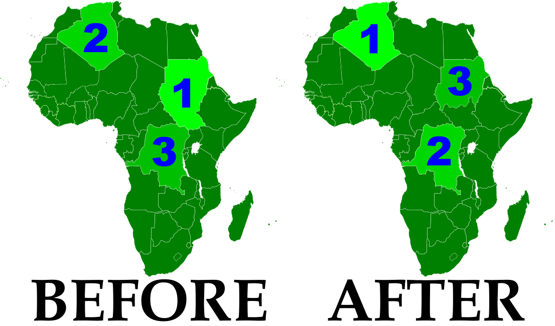
Sudan No Longer Africa's Largest Country
Now that the South Sudan has gained independence (See: New Country - South Sudan), the remainder of Sudan is no longer Africa's largest country by area. Sudan's one-time top spot was  followed by Algeria in second place and the Democratic Republic of the Congo in third. However, the secession of South Sudan  removed a substantial portion of Sudan's territory, and the northern remainder of the country now ranks third in Africa - after Algeria and the DRC. South Sudan ranks 19th, out of a total of 54 U.N.-recognized countries in Africa. (Graphic my own work, based on this map by Wikipedia user Mangwanani. License: CC BY-SA)

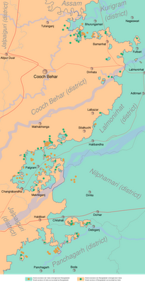
Map showing most of the Cooch Behar
enclaves. By Dutch Wikipedia user
Jeroen (source). License: CC BY-SA
Wikipedia: List of African Countries and Territories

Indo-Bangladesh Treaty Defines Border, Trades Enclaves
A treaty signed last month between the governments of India and Bangladesh fully defines the border between the two countries, and provides for the trade of dozens of enclaves. The Indo-Bangladesh enclaves, also known as "chitmahals" or the "Cooch Behar enclaves" (after the district of India which most of them either belong to or are located inside), number well over 100, including patches of Indian territory within Bangladesh and patches of Bengladeshi territory within India. Their inhabitants have long suffered under abominable living conditions due to the fact that they have access neither to services from their own country (because of their isolation) nor to services from the country surrounding them (because they are not considered part of its territory). Under the new agreement, based on a 1974 deal that was never adopted, nearly all of the enclaves will be ceded to whichever country surrounds them, and inhabitants will have a choice of citizenship. The two parties also defined the border in several previously disputed or undemarcated areas. The treaty will not go into effect until it is ratified by both countries' legislatures.


Location of Rastan within Syria. Based on this
map
by German Wikipedia user NordNordWest.
License: CC BY-SA
Syrian City Falls Briefly to Rebels
In Syria's ongoing uprising, the city of Rastan fell under control of protester-friendly rebel forces for a few weeks last month, before ultimately being retaken by government troops. The crisis in Syria, seen as part of the so-called "Arab Spring" movement for democratic change in the Middle East, began with protests last January. By march it had escalated to widespread displays of defiance in the streets, to which the government responded by sending in tanks and soldiers. However, the resistance was mostly unarmed until army defectors began organizing against the military in September. The city of Rastan, one of several major protest centers, was taken over by anti-government forces, which were not driven out until October 1. So far there have been no more reports of Syrian cities falling under armed anti-government control, but protests and violent government crackdowns continue in full gear.