Wednesday, March 29, 2023

2022: Donetsk & Lugansk People's Republics Stop Claiming Independence

Most of our readers will already have heard of this story last year, but because PolGeoNow is committed to providing a record of all changes to the world's list of countries, and because this aspect of the story hasn't been much discussed, we're still publishing an article about it now. Parts of this article are adapted from our story on Recognition of the Donetsk and Lugansk People's Republics from one year ago.

Map of territorial control within the claimed borders of the self-declared Donetsk People's Republic (DPR) and Lugansk People's Republic (LPR) as of September 26, 2022, a week before they stopped claiming independence after their claimed merger with Russia (annexation). Map shows that all of the LPR, otherwise known as Ukraine's Luhansk province, was under the control of Russian and LPR forces, while Russian and DPR forces controlled over half of the DPR, or Ukraine's Donetsk province, including the major central and southern cities of Donetsk, Horlivka, Makiyivka, and Mariupol. Colorblind accessible.
Actual military/administrative control within the DPR and LPR's claimed borders just before their governments' agreed merger into Russia. This was also roughly their greatest extent of control during the period they claimed to be independent countries, if including territory held by their close ally the Russian military. This map was originally published as part of our subscriber-exclusive September 2022 Ukraine control map report.

Partial Recognition

For eight years, from 2014 to 2022, the so-called Donetsk People's Republic (DPR) and Lugansk People's Republic (LPR) said they were independent countries, despite most of the world considering them to be parts of Ukraine. Then late last year, they stopped claiming independence, instead saying they had now become part of Russia, after Russia controversially agreed to take them in. Read on for the full story, explained in plain English...

How Many Countries Are There in the World in 2023?

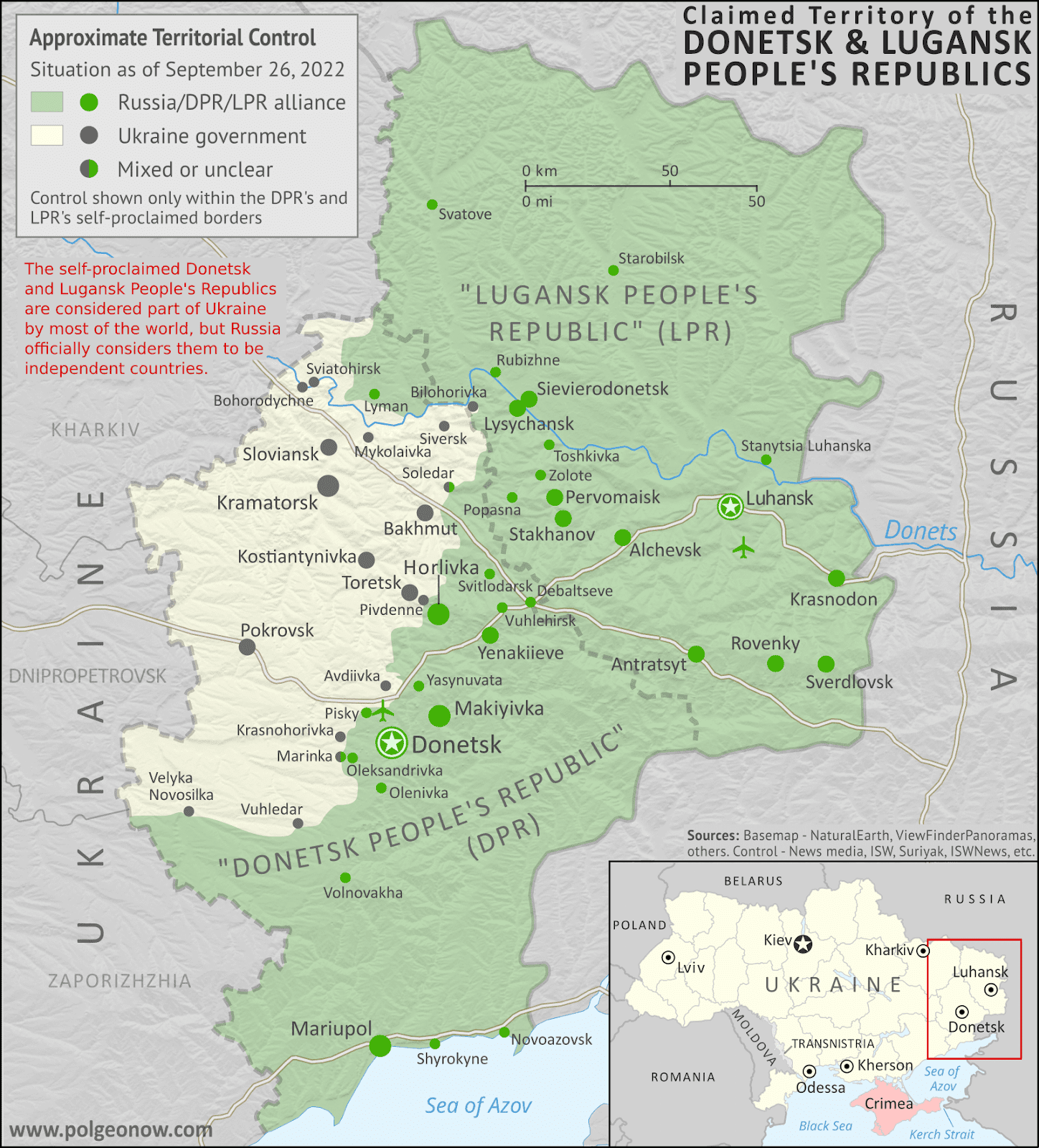
This article, originally from 2011, has been revised and updated to March 2023. You can view older versions of the article in our archives. The main update from last year is the so-called Donetsk and Lugansk People's Republics no longer claiming to be independent countries.

How many countries: map of the world
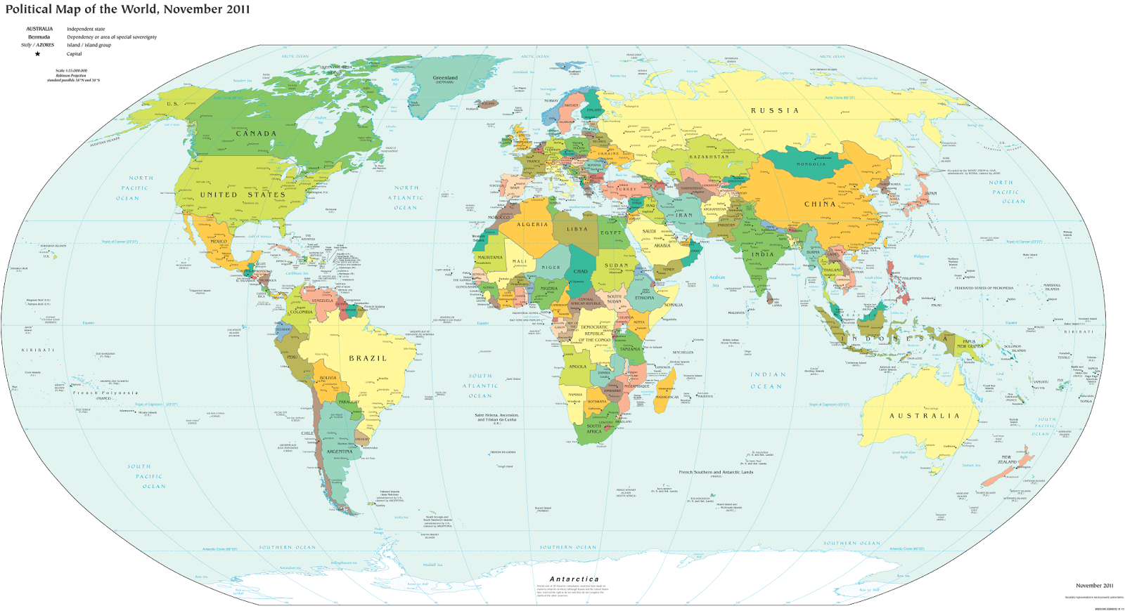
A world political map published by the US government.

One of the most basic questions for map-lovers is "How many countries are there in the world?" But anyone who just gives you a simple number isn't telling the whole truth. It actually depends a lot on how you define a "country". Here are six of the most common answers, each correct in its own way:

Tuesday, March 28, 2023

Ukraine: Map of Russian Control in March 2023 (Subscription)

SUBSCRIBERS CLICK HERE TO VIEW FULL ARTICLE AND MAP:
Old Portal (members.polgeonow.com) | New Portal (controlmaps.polgeonow.com)


There are newer editions of this map available. To see them, view all Ukraine articles on PolGeoNow.

Research by Djordje Djukic. Map by Evan Centanni and Djordje Djukic

Subscribe for full access to all conflict map reports!

Thumbnail previewing map of Russian-controlled territory in Ukraine on March 26, 2023. In addition to the Crimean peninsula, which Russia had already seized in 2014, and parts of the far eastern Donetsk and Luhansk provinces (the Donbas region) already controlled by Russia-backed separatist rebels (and formerly declared independent as the Donetsk and Lugansk People's Republics), Russian forces still control a wide belt of territory just north of Crimea, including large parts of Kherson and Zaporizhzhia provinces, as well as large additional areas of Donetsk and Luhansk provinces. Meanwhile, all of those provinces are now claimed by the Russian government as parts of Russia, creating a new claimed international border through what was until recently undisputed eastern Ukraine. Map includes key locations from the news, such as Bakhmut, Marinka, Kupiansk, Potemkin Island, and more. Colorblind accessible.

In the past month almost all territorial changes in Ukraine have been in favor of Russia, and mostly all within the Donetsk region. Though most of Russia's advances have been too small to show up on our maps, it's made major progress towards capturing the small city of Bakhmut.

See all this and more on the latest update to PolGeoNow's concise, professional Ukraine war control map, which includes a detailed chronicle of changes and events since our previous Ukraine map report of February 21, with sources cited, as well as a close-up map of control within the claimed borders of the Donetsk and Lugansk People's Republics (now claimed to be self-governing regions within Russia).

This map and report are premium content, available to paid subscribers of the PolGeoNow Conflict Mapping Service.

Want to see before you subscribe? Check out our most recent FREE SAMPLE Ukraine map!

Exclusive map report includes:

  • Up-to-date illustration of current territorial control in Ukraine, color-coded for the Ukrainian government on one side and the Russian military and allied forces on the other side, with areas of uncertainty indicated. Colorblind accessible.
  • Darker color indicating which areas were already under Russian or allied control before the 2022 invasion began
  • Lines showing Russia's newly-claimed border after its annexations of Donetsk, Luhansk, Zaporizhzhia, and Kherson provinces.
  • Preview thumbnail of map of territorial control within the claimed borders of the self-declared Donetsk People's Republic (DPR) and Lugansk People's Republic (LPR), which now consider themselves part of Russia, updated to March 26, 2023. Map shows that the vast majority of the LPR, otherwise known as Ukraine's Luhansk province, is now under the control of Russia, while Russian forces also control over half of the DPR, or Ukraine's Donetsk province, including the major central and southern cities of Donetsk, Horlivka, Makiyivka, and Mariupol. Includes key locations from the news, such as Bakhmut, Marinka, Torske, Pervomaiske, and many more. Colorblind accessible.
    Donbas close-up map
    Close-up map of territorial control within the self-proclaimed boundaries of the Donetsk People's Republic and Lugansk People's Republic, which now claim to be part of Russia
  • Detailed indication of city-by-city control, including key towns and other locations important to current events
  • Locations of recent control changes and other important events, including Bakhmut, Marinka, Pervomaiske, Torske, Potemkin Island, and many more
  • Detailed timeline of important events and changes to territorial control since February 21, 2023, with links to sources.

SUBSCRIBERS CLICK HERE TO VIEW FULL ARTICLE AND MAP:
Old Portal (members.polgeonow.com) | New Portal (controlmaps.polgeonow.com)


Not signed up yet? Click here to learn more about our professional subscription service!

Can I purchase just this map?
This map and report are not available for automated purchase to non-subscribers. If you need access or republication rights for only this map report, contact service@polgeonow.com for options.

Saturday, March 11, 2023

Yemen Control Map & Report - March 2023 (Subscription)

SUBSCRIBERS CLICK HERE TO VIEW FULL ARTICLE AND MAP:
Old Portal (members.polgeonow.com) | New Portal (controlmaps.polgeonow.com)


(To see other maps in this series, view all Yemen articles on PolGeoNow.)

Timeline by Djordje Djukic. Map by Evan Centanni, Djordje Djukic, and onestopmap.com

Thumbnail preview of map of what's happening in Yemen as of March 2023, showing territorial control in the PLC government infighting between Saudi-backed al-Islah and the UAE-backed STC southern separatists, as well as control by the unrecognized Houthi government and major areas of operations of Al Qaeda in the Arabian Peninsula (AQAP). Includes recent locations of fighting and other events, such as Mudiyah, Mahfad, and the Omaran Valley.

Subscribe for full access to all conflict map reports!

The separatist Southern Transitional Council has significantly consolidated its control of the south, driving Al Qaeda forces out of key strongholds and winning battles against rival affiliates of Yemen's internationally-recognized coalition government.

See all this and more on the newest update to PolGeoNow's Yemen territorial control map, which includes a timeline of changes and important events since our previous Yemen map report in April.

This map and report are premium content available to paid subscribers of the PolGeoNow Conflict Mapping Service.

Want to see before you buy? Check out our most recent FREE SAMPLE Yemen map report!

Exclusive report includes:

  • Up-to-date map of current territorial control in Yemen amid the new outbreak of fighting between factions affiliated to the internationally-recognized government, color-coded for the UAE-backed separatist Southern Transitional Council (STC) and allies, Islah party and other remaining government units, Houthi forces, and major presence of Al Qaeda in the Arabian Peninsula (AQAP)
  • Detailed indication of town-by-town control, including provincial boundaries, all major cities, and many smaller ones
  • Markers for recent areas of fighting, including Mudiyah, Mahfad, and the Omaran Valley
  • Timeline of changes to the situation since September 6, 2022, with links to sources 

SUBSCRIBERS CLICK HERE TO VIEW FULL ARTICLE AND MAP:
Old Portal (members.polgeonow.com) | New Portal (controlmaps.polgeonow.com)


Not a member yet? Click here to learn more about our professional subscription service!

Can I purchase just this map?
This map and report are not available for automated purchase to non-subscribers. If you need access or republication rights for only this map report, contact service@polgeonow.com for options.

Tuesday, February 28, 2023

Ukraine: Map of Russian Control in February 2023

There are newer editions of this map available. To see them, view all Ukraine articles on PolGeoNow.Hidden image for crawlers
Map of Russian-controlled territory in Ukraine on February 21, 2023. In addition to the Crimean peninsula, which Russia had already seized in 2014, and parts of the far eastern Donetsk and Luhansk provinces (the Donbas region) already controlled by Russia-backed separatist rebels (and formerly declared independent as the Donetsk and Lugansk People's Republics), Russian forces still control a large strip of territory just north of Crimea, including large parts of Kherson and Zaporizhzhia provinces, as well as large additional areas of Donetsk and Luhansk provinces. Meanwhile, all of those provinces are now claimed by the Russian government as parts of Russia, creating a new claimed international border through what was until recently undisputed eastern Ukraine. Map includes key locations from the news, such as Bakhmut, Synkivka, Marinka, Snake Island, and more. Colorblind accessible.
Map by Evan Centanni and Djordje Djukic. Contact us for permission to use this map.

VIEW THIS ARTICLE IN THE MEMBER AREA:
Old Portal (members.polgeonow.com) | New Portal (controlmaps.polgeonow.com)


Timeline by Djordje Djukic

Map of territorial control within the claimed borders of the self-declared Donetsk People's Republic (DPR) and Lugansk People's Republic (LPR), which now consider themselves part of Russia, updated to February 21, 2023. Map shows that the vast majority of the LPR, otherwise known as Ukraine's Luhansk province, is now under the control of Russian, while Russian forces also control over half of the DPR, or Ukraine's Donetsk province, including the major central and southern cities of Donetsk, Horlivka, Makiyivka, and Mariupol. Includes key locations from the news, such as Bakhmut, Krasna Hora, Ivanivske, Klischivka, Marinka, Vulhedar, and many more. Colorblind accessible.
Map showing what parts of the claimed territory of the self-declared Donetsk and Lugansk People's Republics - now claimed as part of Russia - are controlled by Russian forces and allies, compared to the Ukrainian government. Click to enlarge.

Russian Advances: Steady, but Slow

In the month following our previous Ukraine war control map report, the advantage has remained with Russia, though not by much. 

While Ukraine has made some very small advances, Russian forces have achieved still-small but more-significant gains, nearly cutting off Ukrainian supply lines to the small city of Bakhmut in Donetsk.

Russia has also made small advances in the contested area west of Donetsk city, and in the northeastern corner of mostly-Ukraine-controlled Kharkiv province - the only remaining area of Russian control that it doesn't officially claim as part of Russia.

Meanwhile, Snake Island in the Black Sea is now known to be held by Ukraine, after reports following Russia's mid-2022 withdrawal had left the situation unclear.

This report describes the situation as of one week ago, on February 21, 2023.