Thursday, September 9, 2021

Have Afghanistan's Flag and Official Name Changed?

Flag of the Taliban's Islamic Emirate of Afghanistan, featuring the Islamic Shahada text in black calligraphy over a plain white backdrop
Taliban flag of Afghanistan*

Flag of the (non-Taliban) Islamic Republic of Afghanistan, featuring a white-outlined seal over black, red, and green bars
Non-Taliban flag of Afghanistan


*Alternative versions of the Taliban flag include "Islamic Emirate of Afghanistan" or "Long Live the Islamic Emirate of Afghanistan" in Pashto as a smaller line of text at the bottom.

Taliban Takeover

As you probably heard, Afghanistan's Taliban rebel group successfully took over most of the country last month, with the previous national government and military collapsing as the rebels seized the national capital. 

Though the Taliban run what's now, for all practical purposes, the country's actual government, they haven't been officially accepted yet by any of the world's other countries. 

And the issue isn't politically settled so far, both Afghanistan's flag and its full official country name are a matter of dispute, with the Taliban promoting one version and the remnants of the pre-Taliban government promoting another.

Sunday, September 5, 2021

Are Mozambique's insurgents really part of "ISIS"?

This is one of two newly-published supplements to PolGeoNow's Mozambique insurgency control map report series. The other revisits the question of the what the insurgents are actually called, still relevant one year after we first reported on their history and emergence onto the world stage.

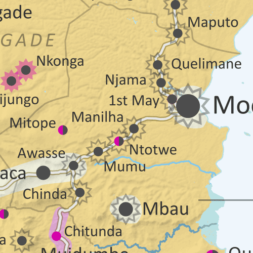
Mozambique: Cabo Delgado conflict map - August 2021: Detailed, close-up control map showing areas occupied by so-called ISIS-linked rebels in northern Mozambique (also known as Ahlu Sunnah Wa Jama, ASWJ, Ansar al-Sunnah, or Al Shabaab), plus towns and villages raided by the insurgents over the past eight months. Situation after Rwandan military intervention that took back Mocímboa da Praia and other towns from the rebels. Shows roads, rivers, and terrain, and includes key locations of the insurgency such as Palma, Awasse, Nchinga, Ntotwe, the Total LNG site and natural gas fields, and many more towns and villages. Updated to August 31, 2021. Colorblind accessible.
Mozambique's insurgents have been pushed out of their most prized territories, but are still fighting on in other areas.

PolGeoNow's coverage of the insurgency in Mozambique's Cabo Delgado province has, as usual, been largely focused on who controls what territory in the conflict - and though insurgents have recently lost their most prominent territorial holdings, they're still a force to be reckoned with. 

But there's one big question that still hangs over the story, relevant both to how the outside world should view the insurgency and to what the rebels are even called:

Are Mozambique's insurgents part of "ISIS"?

A year after they made international headlines by capturing and holding onto the major town of Mocímboa da Praia, the short answer is still "probably sort of".

The so-called "Islamic State" (IS; formerly ISIS or ISIL), though it started in Iraq and Syria and still is based there, has also established branches and franchises - with varying degrees of connection to IS headquarters - in far-flung countries around Africa and Asia. So the more specific question is: Are the Cabo Delgado insurgents genuinely connected to IS, and if so, how connected?

What are Mozambique's insurgents called?

This is one of two newly-published supplements to PolGeoNow's Mozambique insurgency control map series. The other provides an update on the question of what links really exist between the insurgents and the so-called "Islamic State" organization (IS; formerly ISIS/ISIL).

Where is ISIS in Mozambique? Full-country map of insurgent control in northern Mozambique, with territorial control, roads, rivers, and terrain. Includes key locations of the insurgency such as Mocímboa da Praia, Palma, Macomia, Mucojo, Quissanga, Meluco, Muidumbe, Mueda, Quiterajo, and Nangade, as well as other important cities such as Pemba, Nampula, and Maputo. Neighboring countries shown, including Comoros, Madagascar, and French territories of Juan de Nova Island, Bassas da India, and Europa Island. Updated to July 29, 2021. Colorblind accessible.
At the height of their control earlier this year, secretive insurgents dominated a small but important corner of Mozambique. (Map from our July 2021 Cabo Delgado update.)
A Nearly-Nameless Insurgency

In our August 2020 Mozambique conflict map article, we discussed confusion over the name of the insurgent group operating in Cabo Delgado province. Now, a year later, we've decided it's time to briefly revisit that question. 

Though the fighters have now been pushed out of their most prized territories, they're still present in the region in large numbers, so questions about their identity remain highly relevant.

Al Shabaab in Mozambique?

At this point there's no longer much question that the group's most commonly-used name in Cabo Delgado - by both its opponents and the insurgents themselves - is "Al-Shabab". This unofficial name, which means "the youth" in Arabic (the international language of the Islamic religion, but not of everyday communication in Mozambique), appears to be a reference to the Al Shabaab insurgent group in Somalia. Though the word is usually spelled "Shabaab" in the Somali context, and international commentary often uses this spelling for the Cabo Delgado insurgents too, local spelling conventions in Mozambique tend to prefer "Shabab" without the double A.

Tuesday, August 31, 2021

Mozambique Control Map: Rebels Lose Mocímboa da Praia - August 2021 (Subscription)

SUBSCRIBERS CLICK HERE TO PROCEED TO ARTICLE AND MAP

There are newer editions of this map available. To see them, view all Mozambique articles on PolGeoNow.

Map by Evan Centanni and Djordje Djukic. Timeline by Djordje Djukic.

Subscribe for full access to all conflict map reports!

Mozambique: Cabo Delgado conflict map - August 2021: Detailed, close-up control map showing areas occupied by so-called ISIS-linked rebels in northern Mozambique (also known as Ahlu Sunnah Wa Jama, ASWJ, Ansar al-Sunnah, or Al Shabaab), plus towns and villages raided by the insurgents over the past month. Situation after Rwandan military intervention that took back Mocímboa da Praia and other towns from the rebels. Shows roads, rivers, and terrain, and includes key locations of the insurgency such as Palma, Awasse, Nchinga, Ntotwe, the Total LNG site and natural gas fields, and many more towns and villages. Updated to August 31, 2021. Colorblind accessible.
After the intervention of Rwandan forces, Insurgents aligned with the so-called "Islamic State" (ISIS/ISIL) have been pushed out of their most notable territories in Mozambique's far northern province of Cabo Delgado. However, they're believed to still be active in large numbers in more remote areas.
 
See all this and more on the newest update to PolGeoNow's Mozambique territorial control map, which includes a timeline of changes and important events since our previous Cabo Delgado map report in July.

This map and report are premium content, available to paid subscribers of the PolGeoNow Conflict Mapping Service.

(Note: Though Rwanda's defense department has been seen using our Cabo Delgado map in a press briefing, PolGeoNow has no known contact or business relationship with the Rwandan government or military, and the map was used without our prior knowledge. As always, PolGeoNow does not endorse any actor, organization, or policy in any armed conflict or political dispute.)

Want to see before you subscribe? Check out our most recent FREE SAMPLE Mozambique map!

Exclusive map report includes:

  • Detailed illustration of approximate current territorial control in Mozambique's Cabo Delgado province, color-coded for insurgents affiliated with the so-called "Islamic State" (ISIS/ISIL) vs. the Mozambican government and allies (including Rwandan and SADC troops). Areas of contested or unclear control indicated separately. Colorblind accessible. 
  • Detailed indication of city-by-city control status, including for many relevant smaller towns and villages.
  • Detailed indication of which towns and villages have subject to insurgent raids or pro-government military operations since late July 2021.
  • Contextual details including district boundaries, rivers, major roads, and terrain.
  • Sites of international economic interest: Total's suspended LNG site, offshore natural gas fields, and Montepuez ruby mine.
  • Key locations from the news, including Palma, Mocímboa da Praia, Awasse, Ntotwe, Nchinga, and many more.
  • Accompanying article with detailed timeline of territorial control changes and key political and military developments since late July, with sources cited. 

SUBSCRIBERS CLICK HERE TO PROCEED TO ARTICLE AND MAP

Not signed up yet? Click here to learn more about our professional subscription service!

Tuesday, August 10, 2021

Guest Feature: Map of Control in Ethiopia's Tigray Conflict (August 2021)

Update: PolGeoNow now has an in-house map showing territorial control in northern Ethiopia. To find the latest version, view all Ethiopia reports.

In a dramatic reversal, Tigray rebels are now on the offensive after recapturing their state's capital in northern Ethiopia. To illustrate the current situation, PolGeoNow is again honored to feature a territorial control map created by our colleague Daniel from Passport Party. Also included is a timeline of events since the previous update in February.

Tigray control map: Rough illustration of territorial control in Ethiopia's Tigray war as known August 9, 2021, showing which areas have been retaken by Tigrayan rebels both inside and outside of the Tigray regional state. By Daniel of Passport Party.
Map of control in Tigray and surrounding areas in early August 2021, by Daniel of Passport Party (used with permission).


Ethiopia Conflict: Updated Control Map 

Since our previous Tigray conflict article in February, the war in Ethiopia's Tigray state has undergone a major shift. Where just months ago the Tigrayan rebels fighting in the name of the former TPLF state government had been reduced to a guerilla forces striking from the hills, they've now recaptured the state capital and continue to advance even beyond the state's borders in a show of strength against the Ethiopian federal government. Though many details of the situation on the ground are still fuzzy, Daniel's latest map - a specially-made update to one published on his Passport Party Twitter account last month - approximates the current lines of control in early August.