Friday, June 23, 2017

Why Brexit Matters: 5 Things That Might Change When Britain Leaves the EU

By Bryn Jansson

Map of the European Union, including all member countries, official candidate countries, and potential candidate countries, as 2017 (colorblind accessible).
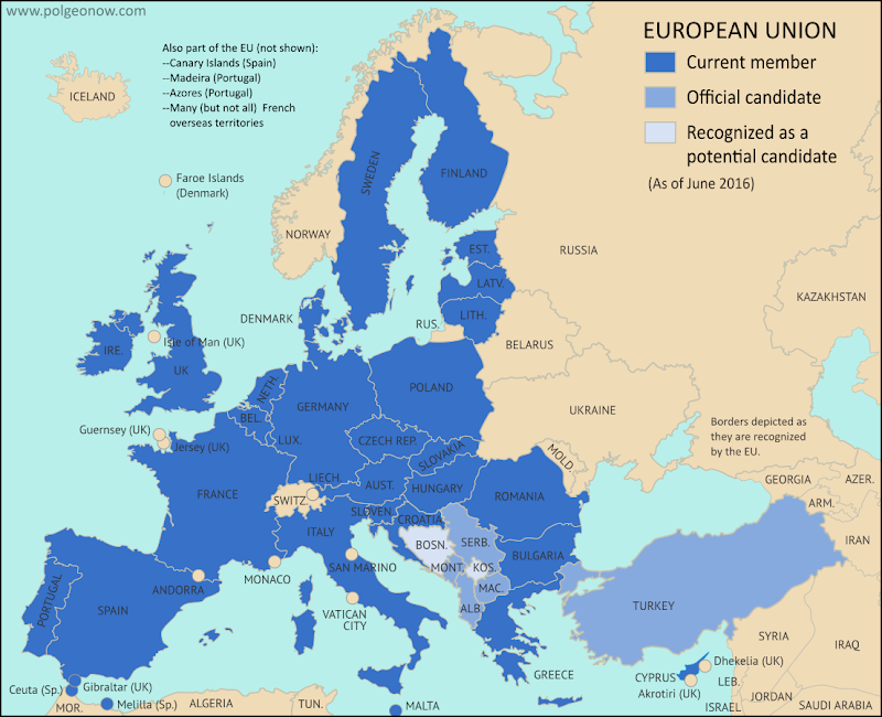
Map of current and future EU member countries

Brexit Process Finally Begins

The United Kingdom (UK) and the European Union (EU) began formal divorce negotiations in Brussels last Monday, June 19, starting a 21-month sprint to the March 2019 Brexit deadline. ("Brexit" is short for "British Exit" from the EU, since "Britain" is another name for the UK.)

UK voters’ surprise choice to leave the EU happened exactly a year ago, on June 23, 2016 - but it didn’t automatically trigger the two-year countdown clock on exit negotiations necessary for departure under Article 50 of the EU’s Lisbon Treaty.


Thursday, June 22, 2017

Syrian Civil War Map & Timeline: Kurds Enter "Islamic State" Capital - June 2017

There are newer versions of this map available. To see them, view all Syria updates.

Map of Syrian Civil War (Syria control map): Fighting and territorial control in Syria in June 2017 (Free Syrian Army rebels, Kurdish YPG, Syrian Democratic Forces (SDF), Jabhat Fateh al-Sham / Hayat Tahrir al-Sham (Al-Nusra Front), Islamic State (ISIS/ISIL), and others). Includes Russia-Turkey-Iran agreed de-escalation zones and US deconfliction zone. Includes recent locations of conflict and territorial control changes, such as Raqqah, Maskanah, Arak, Tanf, Sabaa Biyar, Bir Qassab, and more. Colorblind accessible.
Base map by Koen Adams of onestopmap.com, with territorial control by Evan Centanni and Djordje Djukic.
All rights reserved.
(Subscribers click here to view this article in the member area.)

Timeline by Djordje Djukic

Syria: Where Things Stand Now

In the four weeks since our previous Syrian Civil War map report, the US-backed, Kurdish-led Syrian Democratic Forces (SDF) have advanced all the way into Raqqah, capital city of the so-called "Islamic State" (IS; formerly ISIS/ISIL). Meanwhile, Syrian government forces have also been pushing hard against IS, nearing Raqqah themselves, while making even more major advances in the southern desert. Clashes between rebels and government forces have also continued across Syria's south, even as the US enforces a rebel safe zone around its base in Tanf.

Friday, June 16, 2017

Iraq Control Map & Timeline - June 2017 (Subscription)

SUBSCRIBERS CLICK HERE TO PROCEED TO ARTICLE AND MAP

There are newer versions of this map available. To see them, view all Iraq updates.

Research by Djordje Djukic. Map by onestopmap.com, Evan Centanni, and Djordje Djukic

Subscribe for full access to all conflict map reports!

Detailed map of territorial control in Iraq as of June 15, 2017, including territory held by the so-called Islamic State (ISIS, ISIL), the Baghdad government, and the Kurdistan Peshmerga. Shows developments in the ongoing coalition battle to recapture the city of Mosul. Includes key locations from recent events, such as Baaj, Al-Hadar, Qayrawan, and the Safouk and Jayar Ghalfas border crossings. Colorblind accessible.
In the past three months, Iraqi government forces have made slow but steady progress against the so-called "Islamic State" in the city of Mosul, while pro-government militias have pushed westward from the city all the way to the Syrian border.

See all this and more on the latest update to PolGeoNow's concise, professional map of control in Iraq's civil war, including a timeline of changes since our previous Iraq map report of March 2017.

This map and report are premium professional content, available to paid subscribers of the PolGeoNow Conflict Mapping Service.

Want to see before you subscribe? Check out our most recent FREE SAMPLE Iraq map report!

Exclusive report includes:
  • Up-to-date map of current territorial control in Iraq, color-coded for the Iraqi government, "Islamic State" (ISIS/ISIL) fighters, and Kurdistan's Peshmerga forces. Colorblind accessible.
  • Detailed indication of town-by-town control, including all major cities and many smaller ones, as well as major roads and provincial boundaries
  • Markers for key areas of recent fighting such as Baaj, Al-Hadar, Qayrawan, and the Safouk and Jayar Ghalfas border crossings
  • Timeline of changes to the situation since mid-March, compiled by our Iraq-Syria specialist, with links to sources
SUBSCRIBERS CLICK HERE TO PROCEED TO ARTICLE AND MAP

Not signed up yet? Click here to learn more about our professional subscription service!

Can I purchase just this map?
This map and report are not available for automated purchase to non-subscribers. If you need access or republication rights for only this map report, contact service@polgeonow.com for options.

Thursday, June 15, 2017

Panama Recognizes China, Stops Recognizing Taiwan (Map)

There are newer versions of this map available. You can always find the latest version, and a list of all related articles, on our Which Countries Recognize Taiwan? page.

Map of who recognizes Taiwan (what countries recognize the Republic of China) in June 2017. Marks countries that have cut diplomatic ties with Taiwan (withdrawn recognition) in the last ten years: Panama, Sao Tome and Principe, and the Gambia. Also answers question: Where is Republic of China located? (Colorblind accessible)
Click to enlarge. By Evan Centanni, modified from public domain blank world map.

Wednesday, June 14, 2017

How Many Countries Are There in the World in 2017?

There are newer editions of this article available. To find the most recent, view all "How Many Countries in the World" updates!

This article, originally from 2011, has been revised and updated to June 2017.

How many countries in the world?
A world political map published by the US government (public domain)
One of the most basic questions for map-lovers is, "How many countries are there in the world?" But anyone who replies with just a number is leaving out part of the story. It actually depends a lot on how you define a "country".

Here are six of the most common answers, each correct in its own way: