 |
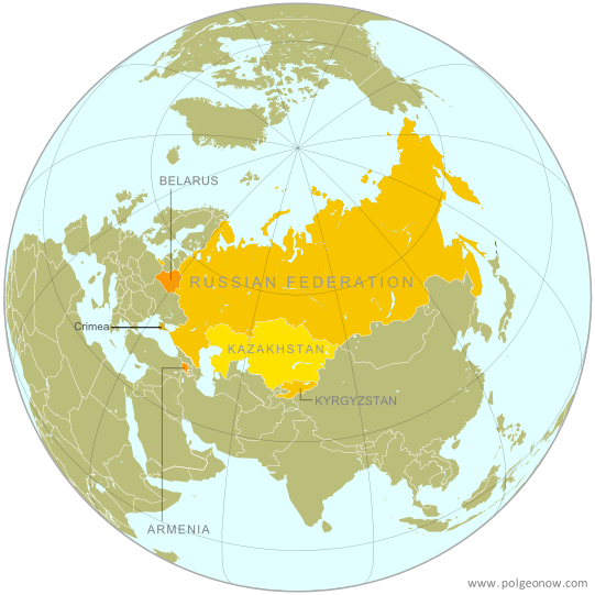
| The Eurasian Economic Union's five current member countries, plus disputed Crimea, claimed to be part of Russia. Map by Evan Centanni, starting from this map by Keverich2. License: CC BY-SA |
Updates on the world's countries and borders
Thursday, May 14, 2015
Map: Another Country Joins the "Eurasian Union" (May 2015)
Thursday, April 30, 2015
Map: Seychelles Join WTO
Paid subscribers click here to view this article in the ad-free members area. Not a subscriber yet? Subscribe now!
 |
| Member and observer states of the World Trade Organization (WTO). Map by Evan Centanni, starting from public domain blank map (license: CC BY-NC-SA). |
Tuesday, April 21, 2015
What is the "Eurasian Union"? (Map)
The Russia-led Eurasian Economic Union, sometimes simply called the "Eurasian Union", was officially launched at the beginning of this year. Read on for a brief introduction to this major new regional organization, which you can expect to hear a lot more about in the coming months and years!
Premium members click here to view this article in the ad-free members area. Not a member yet? Subscribe now!
Article by Karina Barquet
 |
| The Eurasian Economic Union's four current member countries, plus disputed territories officially or unofficially included in the common market. Map by Evan Centanni, starting from this map by Keverich2. License: CC BY-SA |
Article by Karina Barquet
Saturday, April 11, 2015
Syria Civil War Control Map: April 2015 (Subscription)
There are newer versions of this map available. To see them, view all Syria updates.

Research by T.H., with additional reporting by Evan Centanni
Since January, the Islamic State has captured part of Syria's capital city, while rebels have gained important ground in both the north and the south. Meanwhile, Kurdish militias have scored victories against the Islamic State on the northeastern front.
See all this and more on the newest update to PolGeoNow's popular Syria control map, and read a timeline of changes since our previous Syria map report at the end of January.
This map and report are exclusive premium content, available to paid subscribers or for separate purchase.
Download PDF (US$19.99)
Exclusive map report includes:
MEMBERS CLICK HERE TO PROCEED TO ARTICLE AND MAP
NOT A MEMBER YET? SUBSCRIBE NOW!

Download PDF: Buy now |
Since January, the Islamic State has captured part of Syria's capital city, while rebels have gained important ground in both the north and the south. Meanwhile, Kurdish militias have scored victories against the Islamic State on the northeastern front.
See all this and more on the newest update to PolGeoNow's popular Syria control map, and read a timeline of changes since our previous Syria map report at the end of January.
This map and report are exclusive premium content, available to paid subscribers or for separate purchase.
Download PDF (US$19.99)
Exclusive map report includes:
- Up-to-date map of current territorial control in Syria, color-coded for the Assad government, rebel groups, Islamic State (ISIS/ISIL) extremists, and Kurdish self-protection forces
- Detailed indication of city-by-city control, highlighting key towns and other locations relevant to current events
- Locations of recent fighting and military operations, including Yarmouk, Idlib, Nassib border crossing, Busra, and the Tomb of Suleyman Shah (site of Turkey's brief military incursion in February).
- Timeline of changes to important events since the end of January, plus summary of important territorial changes in recent months.
MEMBERS CLICK HERE TO PROCEED TO ARTICLE AND MAP
NOT A MEMBER YET? SUBSCRIBE NOW!
Friday, April 3, 2015
War in Yemen: Map of Territorial Control (April 2015)
Note: There are newer versions of this map available.
This is the second in a two-part report on the ongoing crisis in Yemen, a collaboration between PolGeoNow and CIGeography. Part 1 was the Map & Infographic of Foreign Military Deployments in Yemen.
The below article summarizes the political situation and presents a detailed chronicle of events over the past several months. The map has been updated since Wednesday's infographic.
Subscribers click here to view this article in the ad-free members area. Not a member yet? Subscribe now!
Timeline by Djordje Djukic, with additional reporting by Evan Centanni
The Disintegration of Yemen
When PolGeoNow published our last Yemen control map two and a half years ago, the country appeared to be holding together, if only barely. Authoritarian president Ali Abdullah Saleh had stepped down in an internationally-backed political compromise to end the country's Arab Spring uprising, and the northern Houthi rebels had halted their advances after promises of political involvement.
Al Qaeda was on the run from its claimed emirates in the south after a military campaign overseen by the new President Abdurabuh Mansur Hadi, Saleh's former vice president. A movement for southern independence remained outspoken, but wasn't taking up arms in large numbers against the government.
This is the second in a two-part report on the ongoing crisis in Yemen, a collaboration between PolGeoNow and CIGeography. Part 1 was the Map & Infographic of Foreign Military Deployments in Yemen.
The below article summarizes the political situation and presents a detailed chronicle of events over the past several months. The map has been updated since Wednesday's infographic.
 |
Map by Louis Martin-Vézian and Evan Centanni (click to enlarge). All rights reserved.
|
Timeline by Djordje Djukic, with additional reporting by Evan Centanni
The Disintegration of Yemen
When PolGeoNow published our last Yemen control map two and a half years ago, the country appeared to be holding together, if only barely. Authoritarian president Ali Abdullah Saleh had stepped down in an internationally-backed political compromise to end the country's Arab Spring uprising, and the northern Houthi rebels had halted their advances after promises of political involvement.
Al Qaeda was on the run from its claimed emirates in the south after a military campaign overseen by the new President Abdurabuh Mansur Hadi, Saleh's former vice president. A movement for southern independence remained outspoken, but wasn't taking up arms in large numbers against the government.
Subscribe to:
Posts (Atom)