 |
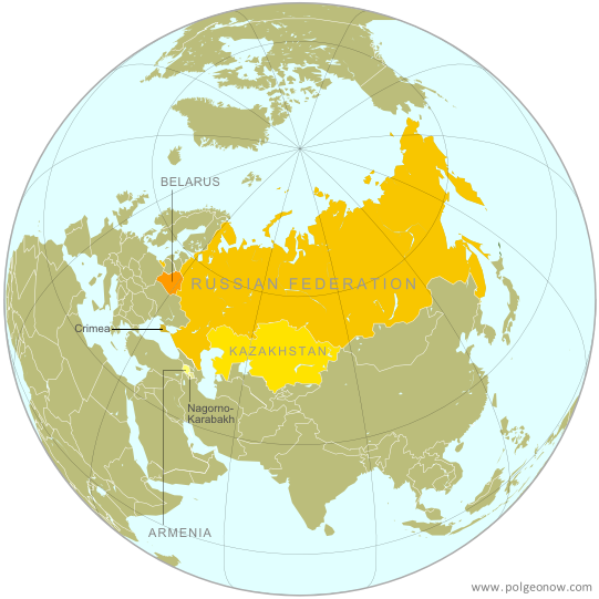
| The Eurasian Economic Union's four member countries, plus disputed territories that might be officially or unofficially included. Map by Evan Centanni, starting from this map by Keverich2. License: CC BY-SA |
Updates on the world's countries and borders
Tuesday, October 14, 2014
Map: "Eurasian Union" Gets New Member
Monday, October 6, 2014
Syria Civil War Map: October 2014 (#15) (Premium)
There are newer versions of this map available. To see them, view all Syria updates.

Our territorial control map of the Syrian Civil War has been updated for October, showing changes to the situation since the previous Syria map report in September. The map and accompanying timeline show the Islamic State's advance against Kurdish-held Kobani, as well as other developments from the past few weeks.
This map and article are exclusive premium content, available to paid subscribers or for individual purchase.
Buy now (US$9.99)
Premium map includes:
MEMBERS CLICK HERE TO PROCEED TO ARTICLE AND MAP
NOT A MEMBER YET? SUBSCRIBE NOW!

Download PDF buy |
This map and article are exclusive premium content, available to paid subscribers or for individual purchase.
Buy now (US$9.99)
Premium map includes:
- Up-to-date map of current territorial control in Syria, color-coded for the Assad government, rebel groups, Islamic State (ISIS) extremists, and Kurdish self-protection forces
- Detailed indication of city-by-city control, highlighting key towns relevant to current events
- Recent areas of fighting, including Kobani (Ayn al-Arab), Deir al-Adas, and others
- Timeline of events since mid-September, with focus on changes to territorial control
MEMBERS CLICK HERE TO PROCEED TO ARTICLE AND MAP
NOT A MEMBER YET? SUBSCRIBE NOW!
Monday, September 29, 2014
War in Nigeria: Map of Boko Haram Control (September 2014)
There are newer versions of this map available. To see them, view all Nigeria updates.
Premium members click here to view this article in the ad-free members area. Not a member yet? Sign up now!
Conflict tracking by T.H., with additional reporting by Evan Centanni
Boko Haram vs. Nigeria
Though it's waged a bloody war against the Nigerian government for many years, rebel group Boko Haram rarely could claim significant territorial control until recently. Though they did take over a number of remote areas in spring of last year (see our 2013 Boko Haram control map), the militants were soon driven back into hiding by the Nigerian military.
The insurgency never went away, with Boko Haram's bombings and other attacks, often on schools and other public places, increasing in number and lethality from 2013 into early 2014. (Also see our 2013 report for more background on Boko Haram).
 |
| Map by Evan Centanni. All rights reserved. |
Conflict tracking by T.H., with additional reporting by Evan Centanni
Boko Haram vs. Nigeria
Though it's waged a bloody war against the Nigerian government for many years, rebel group Boko Haram rarely could claim significant territorial control until recently. Though they did take over a number of remote areas in spring of last year (see our 2013 Boko Haram control map), the militants were soon driven back into hiding by the Nigerian military.
The insurgency never went away, with Boko Haram's bombings and other attacks, often on schools and other public places, increasing in number and lethality from 2013 into early 2014. (Also see our 2013 report for more background on Boko Haram).
Friday, September 19, 2014
Maps of How Scotland's Regions Really Voted
Good geographers know that maps can lie to you. Every map emphasizes some aspects of a place at the expense of others, giving it a lot of power to lead careless readers astray. Maps of Scotland's recent independence referendum are misleading us about the reality, even if not intentionally.
Premium members click here to view this article in the ad-free members area. Not a member yet? Subscribe now!
By Evan Centanni
Misleading Maps
By now you've probably heard the results of Scotland's independence referendum: voters chose "no" by a solid margin of 55% to 45%. Check out our previous article to learn more about what would have happened if Scotland had voted "yes".
Maps like this one from the BBC and this one from Wikipedia have popped up since the results came out, showing how each of Scotland's council areas voted. Most of the country is in red for "no", with a few "yes" areas in green.
But if one area went 51% for "yes", and another 51% for "no", those two areas actually voted almost identically - yet contrasting red/green maps make us feel like they're polar opposites (not to mention that one-in-thirty readers has trouble seeing the difference between red and green).
How the Councils Really Voted
Whether each area's people voted just over or just under 50% in favor isn't actually that important. What matters is how far the balance was tipped in each region. This is not the U.S. presidential election, where the final vote is actually made by delegates obligated to go by the majority in each state. All the votes across Scotland were pooled together to determine the result, so which side of the 50-yard line each area came out on has no effect .
Premium members click here to view this article in the ad-free members area. Not a member yet? Subscribe now!

|
| Map by Evan Centanni, based on blank map by TUBS and NordNordWest (CC BY-SA) |
Misleading Maps
By now you've probably heard the results of Scotland's independence referendum: voters chose "no" by a solid margin of 55% to 45%. Check out our previous article to learn more about what would have happened if Scotland had voted "yes".
Maps like this one from the BBC and this one from Wikipedia have popped up since the results came out, showing how each of Scotland's council areas voted. Most of the country is in red for "no", with a few "yes" areas in green.
But if one area went 51% for "yes", and another 51% for "no", those two areas actually voted almost identically - yet contrasting red/green maps make us feel like they're polar opposites (not to mention that one-in-thirty readers has trouble seeing the difference between red and green).
How the Councils Really Voted
Whether each area's people voted just over or just under 50% in favor isn't actually that important. What matters is how far the balance was tipped in each region. This is not the U.S. presidential election, where the final vote is actually made by delegates obligated to go by the majority in each state. All the votes across Scotland were pooled together to determine the result, so which side of the 50-yard line each area came out on has no effect .
Tuesday, September 16, 2014
Scottish Independence Poll: What is Scotland, and What Will Happen if it Votes to Leave the UK?
Premium members click here to view this article in the ad-free members area. Not a member yet? Subscribe now!
By Evan Centanni
It remained an independent kingdom throughout the Middle Ages, gradually absorbing Anglo-Saxon culture from the south until it came to be ruled by English-speaking monarchs, who called it "Scots" or "Scotland" after the Latin name for the Gaels, the predominant Celtic people of the region.
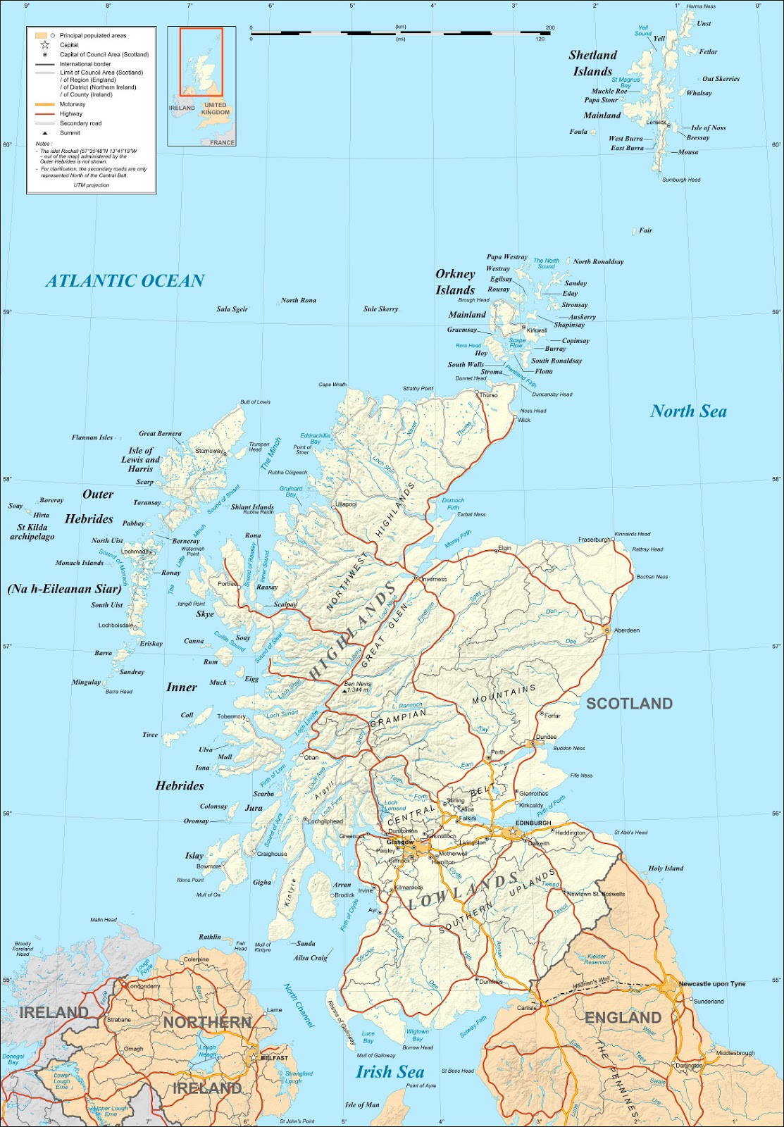 |
| Map of Scotland by Eric Gaba (source). License: CC BY-SA |
Scotland's Independence Vote
On Thursday (September 18), residents of Scotland will vote in a referendum on whether to leave the United Kingdom (UK). But is Scotland a country already? What will happen if voters choose "yes" in the referendum? And what other changes would this bring to Scotland and the UK's political geography? Read on for the answers to these questions and more!Crash Course: History of Scotland
Scotland is the name of the northern third of Great Britain, the main island of the UK, which is shared with England to the south and Wales to the southwest. It originated as the Kingdom of Alba, an independent Celtic country that was unified around the year 900.It remained an independent kingdom throughout the Middle Ages, gradually absorbing Anglo-Saxon culture from the south until it came to be ruled by English-speaking monarchs, who called it "Scots" or "Scotland" after the Latin name for the Gaels, the predominant Celtic people of the region.
Subscribe to:
Posts (Atom)