
Download PDF buy |
Members click here to proceed to article and map
NOT A MEMBER YET? SUBSCRIBE HERE!
Updates on the world's countries and borders
Download PDF buy |
 |
Area of fighting and territorial control in Syria's civil war, updated for December 2013. Map by Evan Centanni, starting from this blank map by German Wikipedia user NordNordWest. License: CC BY-SA
|
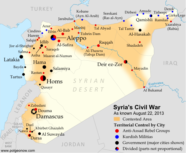 |
Area of fighting and territorial control in Syria's civil war, updated for August 2013. Map by Evan Centanni, starting from this blank map by German Wikipedia user NordNordWest. License: CC BY-SA
|
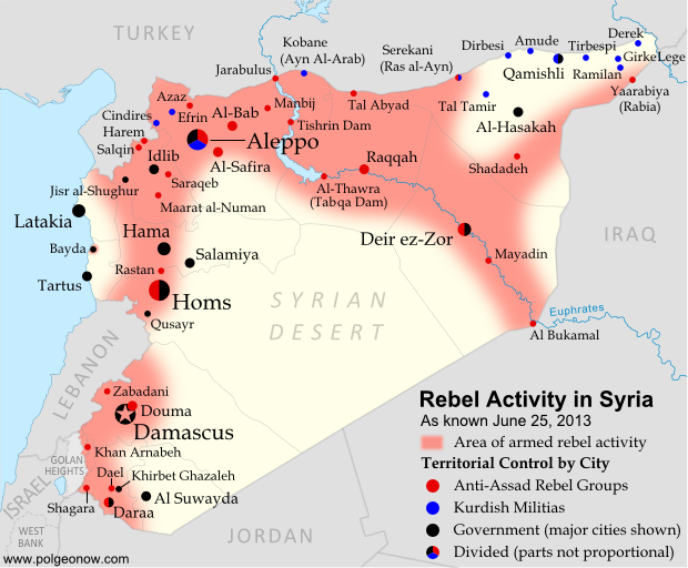 |
Activity and cities held by rebels and other groups in Syria, updated for June 2013. Map by Evan Centanni, starting from this blank map by German Wikipedia user NordNordWest. License: CC BY-SA
|
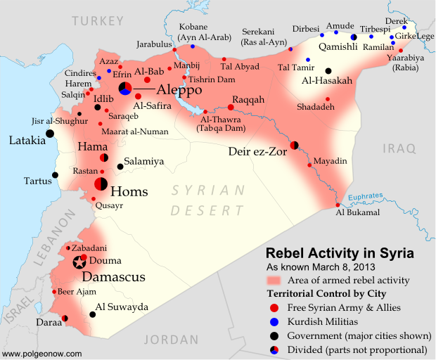 |
Activity and cities held by rebels and other groups in Syria, updated for March 2013. Map by Evan Centanni, starting from this blank map by German Wikipedia user NordNordWest. License: CC BY-SA
|
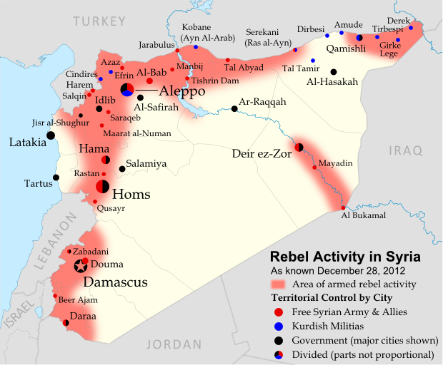 |
Activity and cities held by rebels and other groups in Syria, updated for December 2012. Map by Evan Centanni, starting from this blank map by German Wikipedia user NordNordWest. License: CC BY-SA
|
 |
Activity and cities held by rebels and other groups in Syria, updated for October 2012. Map by Evan Centanni, starting from this blank map by German Wikipedia user NordNordWest. License: CC BY-SA
|
 |
Activity and cities held by rebels and Kurdish groups in Syria, updated August 16, 2012. Map by Evan Centanni, starting from this blank map by German Wikipedia user NordNordWest. License: CC BY-SA
|
 |
Activity by rebel groups in Syria, marking areas of armed conflict as well as towns and cities held. Map by Evan Centanni, starting from this blank map by German Wikipedia user NordNordWest. License: CC BY-SA
|
 |
| Known areas of armed activity for the rebel "Free Syrian Army" (click to enlarge). My own work, starting from this blank map by NordNordWest. License: CC BY-SA |
| Country Name: • Syria (English) • Sūriyya/Sūryā (Arabic) Official Name: • Syrian Arab Republic (English) • al-Jumhūriyyah al-‘Arabīyah as-Sūriyyah (Arabic) Capital: Damascus |
 |
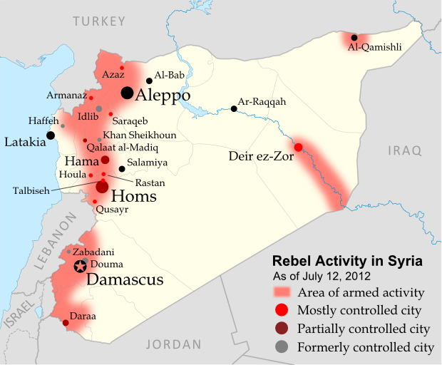
| Known areas of armed activity for the rebel "Free Syrian Army", marking controlled cities and notable towns. Many rural areas may also be under full rebel control. Unarmed protests not shown. Map is my own work, starting from this blank map by German Wikipedia user NordNordWest. License: CC BY-SA |
 |
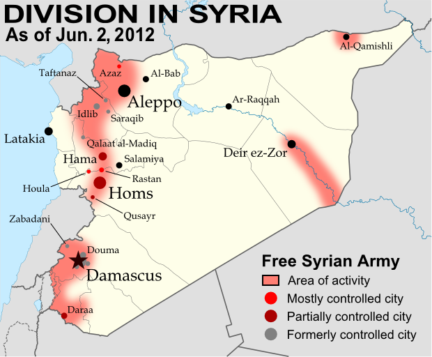
| Known areas of armed activity for the rebel "Free Syrian Army" - many rural areas may be under full rebel control. Unarmed protests not shown. Revised for control of Qalaat al-Madiq and Azaz (see article). Map is my own work, starting from this blank map by German Wikipedia user NordNordWest. License: CC BY-SA |
 |
| Known areas of armed activity for the rebel "Free Syrian Army" - many rural areas may be under full rebel control. Unarmed protests, which are much more widespread than armed rebel activity, are not shown here. Map is my own work, starting from this blank map by German Wikipedia user NordNordWest. License: CC BY-SA |
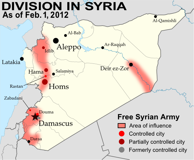 |
| Known areas of armed activity for the rebel "Free Syrian Army" - many rural areas may be under full rebel control. Unarmed protests, much more widespread than armed rebel activity, are not shown here. Map is my own work, starting from this blank map by German Wikipedia user NordNordWest. License: CC BY-SA (Corrected Feb. 26, 2012 for partial Hama control and eastern region activity; again on Mar. 9, 2012 for Rastan control.) |
 |
Map of the Arab Spring. Protests, and in some cases full scale revolutions, have reached across the entire Arab
World. Map is from this Wikipedia page (public domain; original graphic). |
 |
| The Arab League, with Syria in lighter green at top right. Map by Danalm000, from Wikimedia (license: CC BY-SA) |
 |
| Territory and areas of influence for rebels (blue) and Islamic extremists (red) in Yemen. Map is my own work, starting from this map by German Wikipedia user NordNordWest (license: CC BY-SA). (Corrected November 20, 2011) |
 |
Map showing most of the Cooch Behar |
 |
| Location of Rastan within Syria. Based on this map by German Wikipedia user NordNordWest. License: CC BY-SA |