Showing posts with label intergovernmental organizations. Show all posts

Tuesday, December 30, 2014

Kosovo Becomes an Olympic Nation

Premium members click here to view this article in the ad-free members area. Not a member yet? Subscribe now!


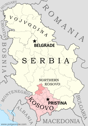
Map of Serbia, Kosovo, and North Kosovo
Kosovo controversially claims independence from Serbia (Northern Kosovo is under partial pro-Serbian control). Map by Evan Centanni, based on these two blank maps by Nord-NordWest. License: CC BY-SA
By Evan Centanni

Next Stop: Rio 2016
Disputed country Kosovo has become the 205th member of the International Olympic Committee (IOC), making it an official Olympic Nation and allowing it to field a team at the 2016 Olympics in Brazil. Its full acceptance came at an IOC meeting in Monaco on December 9, after being granted "provisional recognition" in October.

Kosovo's admission process has been ongoing for five years, and the self-proclaimed country was denied the chance to participate in the London Olympics of 2012. However, one Kosovan athlete attended the games with the team from Albania, a neighboring country with close cultural ties to Kosovo.

Disputed Status
Located in southeastern Europe, Kosovo controversially declared independence from Serbia in 2008, while under the control of UN peacekeepers. Since then, it has been recognized as independent by over half of the world's countries, including the US and most of the European Union. However, Russia, China and many other countries still consider it to be rightfully part of Serbia.

Tuesday, October 14, 2014

Map: "Eurasian Union" Gets New Member

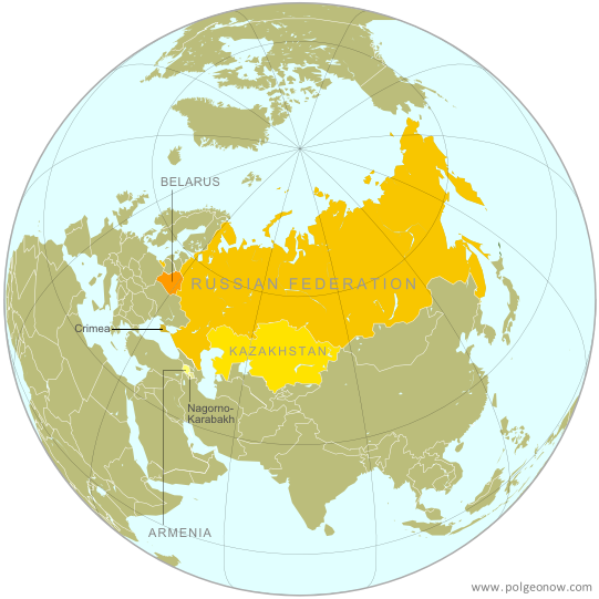
Map of the Eurasian Economic Union (EEU), also known as the Eurasian Union. Includes new member Armenia, as well as prior members Russia, Belarus, and Kazakhstan, and disputed territories Crimea and Nagorno-Karabakh.
The Eurasian Economic Union's four member countries, plus disputed territories that might be officially or unofficially included. Map by Evan Centanni, starting from this map by Keverich2. License: CC BY-SA
Premium members click here to view this article in the ad-free members area. Not a member yet? Subscribe now!

Thursday, August 28, 2014

Latvia Joins the Eurozone (map)

This article was originally published as "Map: Which Countries Use the Euro? (Plus: This Year's New Addition)". To see newer versions of the map, view all Eurozone articles on PolGeoNow.


Map of the Eurozone (euro area), showing which countries use the euro as their currency. Includes members, pre-members (ERM II), EU non-members using the euro, and other EU countries (colorblind accessible).
The Eurozone, European Union, and other countries using the euro.
Map by Evan Centanni, from blank map by Ssolbergj. License: CC BY-SA
Premium members click here to view this article in the ad-free members area. Not a member yet? Subscribe now!

Tuesday, July 29, 2014

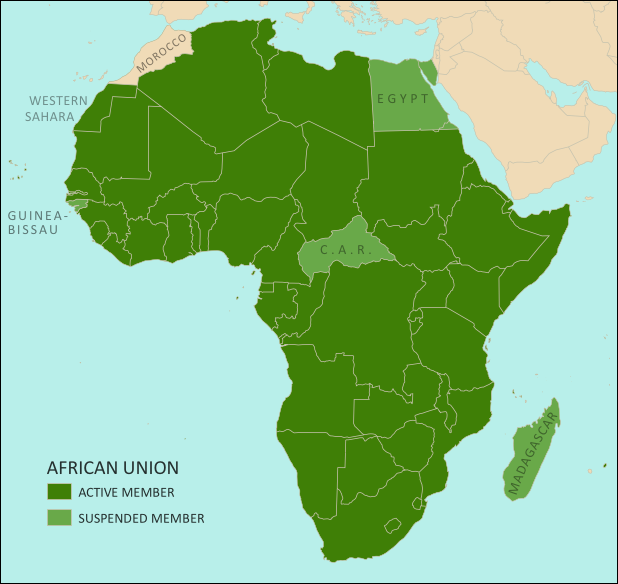
African Union Reinstates Egypt and Guinea-Bissau (Map)

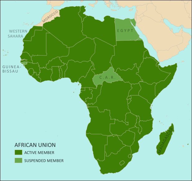
Map of the African Union, including active and suspended members, updated for the June 2014 reinstatement of Egypt and Guinea-Bissau (colorblind accessible).
The African Union as of July 2014. Map by Evan Centanni, from this blank map by Eric Gaba.
License: CC BY-SA
Premium members click here to view this article in the ad-free members area. Not a member yet? Subscribe now!

Thursday, July 10, 2014

Map: Yemen Joins WTO

Premium members click here to view this article in the ad-free members area. Not a member yet? Subscribe now!

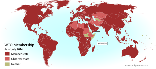
Map of World Trade Organization (WTO) member and observer countries, updated for July 2014 to include new member Yemen
Member and observer states of the World Trade Organization (WTO). Map by Evan Centanni, starting from public domain blank map (license: CC BY-NC-SA).

Sunday, June 8, 2014

Palestine: West Bank and Gaza Reunited Under Transitional Government

(Keep up with changes to Palestine's situation: view all Palestine updates.)

Map of the State of Palestine in the West Bank and Gaza Strip, including both its claimed borders (the Green Line) and zones of actual control (Areas A, B, and C from the Oslo Accords)
Control zones based on the Oslo Accords. Area A: Palestinian control; Area B: mixed Israeli-Palestinian control; Area C: full Israeli control. Map by Evan Centanni (sources: Natural Earth, B'Tselem, U.N. OCHA oPt).
Premium members click here to view this article in the ad-free members area. Not a member yet? Subscribe now!

By Evan Centanni

Unity Government
The partially-unrecognized State of Palestine is not only divided between Palestinian and Israel control - even the Palestinian-administered areas have been governed separately for several years now. However, this month rival parties Hamas and Fatah have finally come together to reunite the West Bank and Gaza Strip under a single Palestinian government.

Divided Country
The rift in control opened up in 2007, after religious militant group Hamas won a majority of seats in the 2006 Palestinian legislative elections. Hamas and Fatah, the current ruling party at the time, failed to form a stable unity government then, and the conflict between them escalated into a short civil war in the Gaza Strip. 

See Also: Is Palestine Really a Country?

Saturday, May 3, 2014

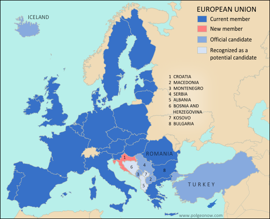
Mayotte Enters European Union

"Outermost regions" are officially part of the European Union; "overseas countries and territories" are not part of the EU itself, but have special relations with it because of their connections to member countries. New outermost region Mayotte is located in southeastern Africa. Map from Wikimedia Commons © Alexrk2 (CC BY-SA)
Premium members click here to view this article in the ad-free members area. Not a member yet? Subscribe now!

Article by Evan Centanni

EU Expands to Include Mayotte
You probably heard about Croatia joining the European Union last year, but did you know the EU expanded further this year...in Africa? The French overseas department of Mayotte, a group of islands in the Indian Ocean northwest of Madagascar, became officially part of the EU on January 1.

Tuesday, April 15, 2014

ICYMI: The Gambia's Withdrawal from the Commonwealth

"In case you missed it" - this is an article featuring news we couldn't cover when it first broke, but that we thought you might still want to know about. Those who read our article on the year 2013 in political geography changes already heard about the Gambia's withdrawal from the Commonwealth of Nations - now here's the full story.

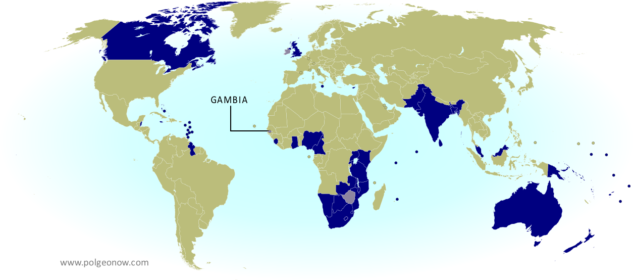
Map of current and former member countries of the Commonwealth of Nations (British Commonwealth) as of 2014, marking the Gambia, which recently withdrew from the organization (colorblind accessible).
The Commonwealth of Nations. Current members in dark blue, former members in lavender. Map by Evan Centanni, modified from public domain blank map.
Premium members click here to view this article in the ad-free members area. Not a member yet? Subscribe now!

Saturday, March 15, 2014

Madagascar Un-Suspended from African Union

Map of the African Union, including active and suspended members, updated for the January 2014 reinstatement of Madagascar (colorblind accessible).
The African Union as of March 2014. Map by Evan Centanni, from this blank map by Eric Gaba.
License: CC BY-SA
Premium members click here to view this article in the ad-free members area. Not a member yet? Subscribe now!

Thursday, May 9, 2013

Who Recognizes Palestine in 2013?

(Keep up with changes to Palestine's situation: view all Palestine updates.)

 Palestine is now an Observer State in the U.N., but it's still not recognized individually by all U.N. member countries. Read on for more about the latest countries to recognize Palestine, plus other recent changes to its international status.
Map of countries that recognize the State of Palestine as an independent country, updated for May 2013 with most recent additions highlighted
Countries recognizing the State of Palestine in green, with most recent additions highlighted in lighter green. Palestine in magenta (circled). Map by Evan Centanni, modified from public domain graphic (source).

Wednesday, March 6, 2013

Map: Laos and Tajikistan Join WTO

Map of World Trade Organization (WTO) member countries, updated for March 2013 to include new members Laos and Tajikistan
World Trade Organization members in green. New members Laos and Tajikistan highlighted (click to enlarge). Map by Evan Centanni, modified from this Wikimedia map by Muso (license: CC BY-SA).

Wednesday, February 13, 2013

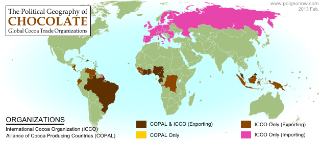
The Political Geography of Chocolate - A Valentine's Day Special

Valentine's Day is just around the corner, and if you thought you were getting a break from geography for sweets and smooching, think again! Political Geography Now presents an introduction to chocolate-based global intergovernmental organizations...

World map showing membership in chocolate-related intergovernmental organizations, the Alliance of Cocoa Producing Countries (COPAL) and the International Cocoa Organization (ICCO)
Map by Evan Centanni, starting from public domain blank world map (source).
International Chocolate Organizations
You've heard of the U.N., the E.U., and the WTO - but those are only some of the most well-known (i.e. boring!) global intergovernmental organizations. This Valentine's Day, you can take a few minutes to learn about the political geography of chocolate - we'll look at two organizations built around the global trade in cocoa beans, the raw ingredient used in making our favorite sweets.

Thursday, December 6, 2012

Is Palestine Really a Country?

(Keep up with changes to Palestine's situation: view all Palestine updates.)

Palestine is now recognized as a country by both the U.N. and a majority of its members, but many  have questioned whether this new-found status reflects the truth on the ground. Is Palestine really an independent country, or is this a political fantasy concocted by supporters in the U.N.?

The Olso Accords divided the Palestinian territories into three areas of control (see article for explanation). Map by Evan Centanni. Sources: Natural Earth, B'Tselem, U.N. OCHA oPt.
What is a "sovereign state"?
By the most common definition, a "state" has to have:
  1. A government
  2. A defined territory
  3. A permanent population
  4. The ability to conduct foreign relations with other states
This definition is called the "declarative theory of statehood", and was formalized in the Montevideo Convention of 1933. To be a "sovereign" state (i.e. an independent country), it's also important that the government answers to no other country, and that the territory and population are actually under the government's control.

A prospective country that fits these criteria is described by geographers as a de facto sovereign state, even if it's not recognized by the international community (de facto is Latin for "in actual fact").

Friday, November 30, 2012

Palestine Recognized as a Country by the U.N.

(Keep up with changes to Palestine's situation: view all Palestine updates.)

This Thursday, the U.N. General Assembly voted to change Palestine's status in the organization from "observer" to "observer state". This is the first time the international body has recognized Palestine as a state, giving it the same status enjoyed by U.N. non-member Vatican City. 

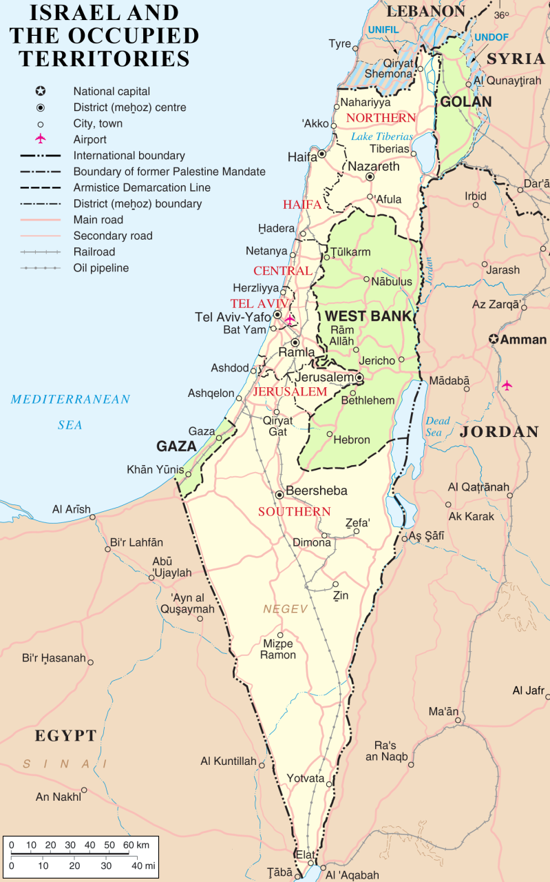
Map of Israel with the occupied territories of the West Bank, Gaza Strip, and Golan Heights highlighted
The State of Palestine claims the West Bank and Gaza, which are largely occupied by Israel. The Golan Heights are not part of the Palestinian Territories. Public domain map (source).
Until this Thursday, Palestine was a partially recognized country, acknowledged by some U.N. member nations, but not by the U.N. itself (See also: How many countries are there in the world?). Although its delegation has had observer status at the U.N. since 1974, it was never classified as a "state", being treated as something between a country and a non-government organization. Now, the organization has officially voted to change Palestine's status to "observer state" - effectively a recognition that it's an independent country, even though it's still not a U.N. member.

The Palestinian delegation campaigned to join the U.N. as a member last year, but had to give up after the U.S. promised to veto the application in the U.N. Security Council. Observer status, on the other hand, is determined by a majority vote in the U.N. General Assembly, which no single country can veto. That vote happened on November 29th, with members voting 138 to 9 in favor of granting Palestine observer state status (41 members abstained, and 5 were absent from the vote; see the full breakdown of national votes).

Tuesday, July 31, 2012

Venezuela Joins Mercosur, Paraguay Suspended

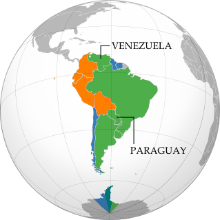
Map of intergovernmental organizations in South America: Mercosur, the Andean Community, and UNASUR (Venezuela and Paraguy indicated)
South America's intergovernmental organizations: Mercosur in green, the Andean Community (CAN) in (orange), and remaining members of UNASUR in blue (claimed territorial extents). Map by Evan Centanni, based on this map by Wikimedia user Luan.
After over six years of waiting, Venezuela today officially joined Mercosur (the "Southern Common Market"), one of South America's two main trade blocs.

The country was previously part of the continent's other major bloc, the Andean Community (CAN), but left that organization last year in anticipation of the switch to Mercosur (see Venezuela Leaves Andean Community).

By the time the Venezuela left CAN last year, its application had finally been approved by all Mercosur member states except for Paraguay; but despite support from that country's president, an opposition party in its congress continued to block Venezuela's entry into the trade organization.

Sunday, April 1, 2012

Mali Conflict Map: Separatists Capture Timbuktu and Gao (April 2012)

Country Name: Mali (English, French, Bambara)
Official Name: Republic of Mali (English), République du Mali (French)
News Category: Divided Countries
Summary: Tuareg-led rebels in northern Mali have now completed their control of the region's major cities, after capturing the military headquarters in Gao as well as historic Timbuktu. Meanwhile, Mali has been suspended from regional organization ECOWAS in response to the recent coup d'etat in the capital, Bamako.

Map of Tuareg rebellion in Northern Mali (Azawad), showing towns controlled by the MNLA rebel group as of April 1, 2012
Towns captured by the Tuareg-majority MNLA rebel group in Mali. Modified from Wikimedia map by Orionist, incorporating images by Carport and NordNordWest (source). License: CC BY-SA.
Full Story: Mali Divided by Separatist Fighting; all Mali map updates

Conflict Update
Again immediately following our last update, northern Mali's National Movement for the Liberation of Azawad (MNLA), made up mostly of Saharan Tuareg people, has followed its victory in Kidal by capturing the region's other two major cities. On March 31, the rebels took control of Gao, headquarters of the Malian military in the north, and the next day overran Timbuktu, a historic former trading post and modern tourism destination. The town of Aguelhok in the north is now also being reported as under Tuareg control, though it is unclear when it was recaptured (the rebels had previously taken and lost it again back in January).

The military government of Mali, which took over in a recent coup d'etat, has now withdrawn its forces from most of northern region, known to the Tuareg rebels as Azawad. Neighboring countries have offered military assistance only if the country returns to democracy, and have suspended Mali's membership in the Economic Community of West African States (ECOWAS) while imposing tough sanctions. If help doesn't come soon, the MNLA could be in the position to declare independence in the north, making Azawad Africa's newest country.

Follow events as they develop on Political Geography Now! To see only stories about this ongoing conflict, filter posts using the Mali label.

Seen this map on Wikipedia?
While Political Geography Now sometimes uses free maps from Wikipedia or other sites (after double-checking their sources), we also occasionally post our own maps to Wikipedia and Wikimedia Commons for others to use. The first version of this particular map of the Tuareg-led rebellion in Mali was created for Wikipedia by Orionist, but I have since taken charge of keeping it updated, with a bit of help from Mnmazur on Wikimedia Commons (Mnmazur is not associated with Political Geography Now).