Tuesday, April 19, 2022

Ukraine: Map of Russian Control on April 18, 2022

There are newer versions of this map available. To see them, view all Ukraine articles on PolGeoNow.
Map of Russian-controlled territory in Ukraine a month and a half into the Russian invasion (April 18, 2022). In addition to the Crimean peninsula, which Russia had already seized in 2014, and parts of the far eastern Donetsk and Luhansk provinces (the Donbass region) already controlled by Russia-backed separatist rebels (and declared independent as the Donetsk and Lugansk People's Republics), Russian forces control a large strip of territory just north of Crimea, including Kherson city and parts of Mariupol, as well as large additional areas of Donetsk and Luhansk, and other areas of Ukraine's northeast. Russia has recently withdrawn from the large area it had captured in north-central Ukraine, including around national capital city Kyiv (Kiev). Map includes key locations from the news, such as Bucha, Mariupol, Izium, Makariv, the Azovstal plant, and many more. Colorblind accessible.
Map by Evan Centanni and Djordje Djukic. Contact us for permission to use this map.

(View this article in the member area)

Timeline by Djordje Djukic

Russia Completes Withdrawal from Northern Ukraine

In the more than two weeks since PolGeoNow's previous Ukraine control map report, Russian forces have completed their withdrawal from north-central Ukraine, and are now beginning a new push to complete their control of the eastern Donbass (Donetsk and Luhansk) region. Fighting this month has largely been focused on the southeastern city of Mariupol, which is now thought to be under full Russian control except for one industrial area. If Russia completes its control there, Mariupol will be the largest city captured since the start of the 2022 invasion.

Tuesday, April 12, 2022

Yemen Control Map & Report: Truce Pauses Fighting - April 2022

There are newer versions of this map available. To see them, view all Yemen articles on PolGeoNow.

Map of what's happening in Yemen as of April 2022, showing territorial control at the time of the new truce (ceasefire), including the unrecognized Houthi government, the former forces of president-in-exile Hadi (now resigned) and his allies in the Saudi-led coalition, and the UAE-backed southern separatist Southern Transitional Council (STC), plus major areas of operations of Al Qaeda in the Arabian Peninsula (AQAP). Includes recent locations of fighting and other events, including Harib, Harad, Maydee (Midi), Yatmah, and many more.
Map by Evan Centanni and Djordje Djukic, from base map by Koen Adams of onestopmap.com.
Contact us for permission to use this map.

(View this article in the member area)

Timeline by Djordje Djukic, with additional reporting by Evan Centanni

Yemen's New Truce: Who Controls What?

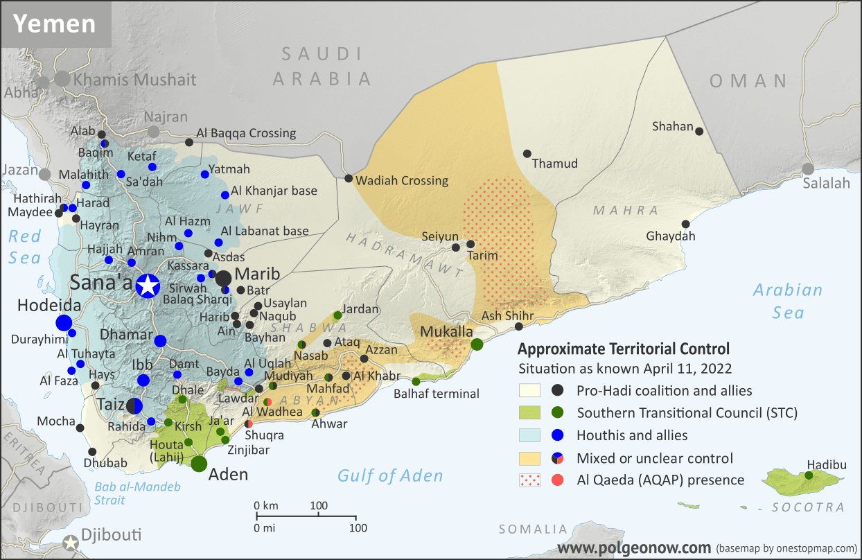
Since our previous Yemen control map report of three months ago, forces of Yemen's unrecognized, Iran-backed Houthi government have rolled back their rivals' recent gains, but still haven't been able to move on the central city of Marib. Amid this stalemate, a surprise UN-brokered truce, alongside the resignation of the country's weak internationally-recognized president, has opened up new possibilities for an end to the war.

Sunday, April 3, 2022

Ukraine: Map of Russian Control on April 2, 2022 (Subscription)

SUBSCRIBERS CLICK HERE TO PROCEED TO ARTICLE AND MAP

There are newer versions of this map available. To see them, view all Ukraine articles on PolGeoNow.

Research by Djordje Djukic. Map by Evan Centanni and Djordje Djukic

Subscribe for full access to all conflict map reports!

Thumbnail preview of map of Russian-controlled territory in Ukraine over a month into the Russian invasion (April 2, 2022). In addition to the Crimean peninsula, which Russia had already seized in 2014, and parts of the far eastern Donetsk and Luhansk provinces (the Donbass region) already controlled by Russia-backed separatist rebels (and declared independent as the Donetsk and Lugansk People's Republics), Russian forces control a large strip of territory just north of Crimea, including Kherson city and parts of Mariupol, as well as large additional areas of Donetsk and Luhansk, and other areas of Ukraine's north and northeast. Russia has recently withdrawn from much of the area it had captured in northern Ukraine in the general area of national capital city Kyiv (Kiev). Map includes key locations from the news, such as Irpin, Vil'khivka, Rubizhne, Trostianets, Marinka, and many more. Colorblind accessible. In the past week, Russian forces have largely withdrawn from the area of capital city Kyiv and other parts of Ukraine's north. But Russia has by no means given up on its invasion, and is now shifting its military focus to consolidating control of Ukraine's east, alongside its allies in the self-proclaimed Donetsk and Lugansk People's Republics.

See all this and more on the latest update to PolGeoNow's concise, professional Ukraine war control map, which includes a timeline of changes since our previous Ukraine map report of March 24, with sources cited.


This map and report are premium content, available to paid subscribers of the PolGeoNow Conflict Mapping Service.

Want to see before you subscribe? Check out our most recent FREE SAMPLE Ukraine map!

Exclusive map report includes:

  • Up-to-date illustration of current territorial control in Ukraine, color-coded for the Ukrainian government on one side and the Russian military and allied rebels on the other side, with areas of uncertainty indicated. Colorblind accessible.
  • Darker color indicating which areas were already under Russian or allied control before the 2022 invasion began
  • Claimed borders of the Russia-backed, self-proclaimed Donetsk People's Republic and Lugansk People's Republic in the eastern Donbass region.
  • Detailed indication of city-by-city control, including key towns and other locations important to current events
  • Locations of recent control changes and other important events, including Irpin, Vil'khivka, Rubizhne, Trostianets, Marinka, and more
  • Detailed timeline of important events and changes to territorial control since March 24, 2022, with links to sources.

SUBSCRIBERS CLICK HERE TO PROCEED TO ARTICLE AND MAP

Not signed up yet? Click here to learn more about our professional subscription service!

Can I purchase just this map?
This map and report are not available for automated purchase to non-subscribers. If you need access or republication rights for only this map report, contact service@polgeonow.com for options.

Monday, March 28, 2022

Recognition of the Donetsk and Lugansk People's Republics

Map of territorial control and frontlines in the Donbass region of Donetsk and Luhansk, internationally recognized as part of eastern Ukraine but partly controlled by the breakaway Donetsk People's Republic and Lugansk People's Republic. Updated for September 2020, with Minsk ceasefire lines shown. Colorblind accessible.
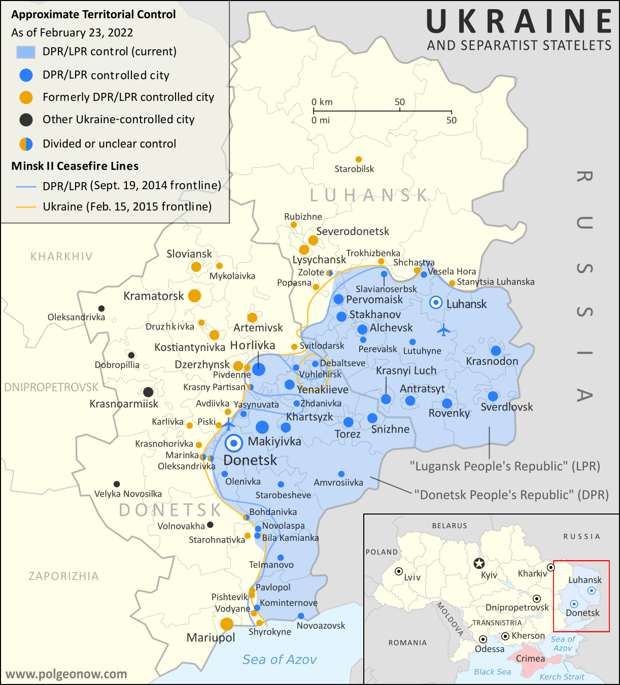
Areas controlled by the self-proclaimed Donetsk and Lugansk People's Republics just before the Russia's full-scale invasion of Ukraine began. For approximate changes that have happened since, check out our Ukraine control map. (Map by Evan Centanni and Djordje Djukic. Contact us for permission to use this map.)

Donetsk and Lugansk: Unrecognized "Republics"

Though now overshadowed by the war, an important political geography event took place in the days leading up to Russia's invasion of Ukraine, changing some versions of the world's list of countries.

Back in April 2014, the month after Russia-backed separatists in the peninsula of Crimea declared their independence from Ukraine, Russia-backed rebels in Ukraine's eastern provinces of Donetsk and Luhansk also announced that they were forming independent countries: the Donetsk People's Republic (DPR) and Lugansk People's Republic (LPR). ("Luhansk" is the Ukrainian-language spelling of the place name, while "Lugansk" is the Russian-language version.)

But unlike Crimea, which had already been secured by Russia's military, and was quickly absorbed into Russia with the permission of its supposed independent government, Donetsk and Lugansk would remain unrecognized for the next eight years - not officially treated as independent countries by any other country, even Russia.*

How Many Countries Were There in the World in 2022?

There are newer editions of this article available. To find the most recent, view all "How Many Countries in the World" updates! 

This article, originally from 2011, has been revised and updated to March 2022. You can view older versions of the article in our archives. The main update from last year is the promotion of the self-proclaimed Donetsk and Lugansk People's Republics from unrecognized to partially-recognized "de facto states".

How many countries: map of the world
A world political map published by the US government.

One of the most basic questions for map-lovers is "How many countries are there in the world?" But anyone who just gives you a simple number isn't telling the whole truth. It actually depends a lot on how you define a "country". Here are six of the most common answers, each correct in its own way: