Wednesday, November 15, 2017

Syrian Civil War Map & Timeline: "Islamic State" Exits Last Major City - November 2017 (Subscription)

SUBSCRIBERS CLICK HERE TO PROCEED TO ARTICLE AND MAP

There are newer versions of this map available. To see them, view all Syria updates.

Research by Djordje Djukic. Map by onestopmap.com, Evan Centanni, and Djordje Djukic

Subscribe for full access to all conflict map reports!

Map of Syrian Civil War (Syria control map): Fighting and territorial control in Syria in November 2017 (Free Syrian Army rebels, Kurdish YPG, Syrian Democratic Forces (SDF), Jabhat Fateh al-Sham / Hayat Tahrir al-Sham (Al-Nusra Front), Islamic State (ISIS/ISIL), and others). Includes Russia-Turkey-Iran agreed de-escalation zones and US deconfliction zone, plus recent locations of conflict and territorial control changes, such as Deir ez-Zor, Abu Kamal (Al Bukamal), Markadeh, Quriyah, and more. Colorblind accessible.Over the past few weeks, the so-called "Islamic State" (ISIS/ISIL) has been completely driven out of its last major city, Deir ez-Zor, and now only controls a few smaller towns and the surrounding desert. Its enemies, the Russia-backed Syrian government and the US-backed Syrian Democratic Forces (SDF), are both moving in to take its place.

See all this and more on the latest update to PolGeoNow's concise, professional Syrian Civil War control map, which includes a timeline of changes since our previous Syria map report in October, with sources cited.

This map and report are premium content, available to paid subscribers of the PolGeoNow Conflict Mapping Service.

Want to see before you subscribe? Check out our most recent FREE SAMPLE Syria map!

Exclusive map report includes:
  • Up-to-date illustration of current territorial control in Syria, color-coded for the Assad government, rebel groups, "Islamic State" (ISIS/ISIL) fighters, and Kurdish/SDF forces. Colorblind accessible.
  • Markers showing the approximate locations of Russian-Turkish-Iranian "de-escalation zones" and the one known US "deconfliction zone".
  • Special symbols indicating towns dominated by rebels of the former Al Qaeda Nusra Front (now Hayat Tahrir al-Sham) and US-backed Syrian Democratic Forces (SDF).
  • Detailed indication of city-by-city control, including key towns and other locations important to current events.
  • Locations of recent fighting and other important events, including Deir ez-Zor, Abu Kamal (Al Bukamal), Markadeh, Quriyah, and more.
  • Detailed timeline of important events and changes to territorial control since October 26, 2017, compiled by our Syria-Iraq expert, with links to sources.

SUBSCRIBERS CLICK HERE TO PROCEED TO ARTICLE AND MAP

Not signed up yet? Click here to learn more about our professional subscription service!

Can I purchase just this map?
This map and report are not available for automated purchase to non-subscribers. If you need access or republication rights for only this map report, contact service@polgeonow.com for options.

Saturday, October 28, 2017

Catalonia Declares Independence from Spain: What Now?

This report is part of our Referendum 2017 coverage, spotlighting disputed independence votes for Kurdistan in Iraq and Catalonia in Spain, plus less-controversial self-rule referendums in three areas of Italy.

Catalonia and Spain: Map of Catalonia's location within Spain and relative to neighboring countries, including Spanish capital Madrid and Catalan capital Barcelona.
Map by Evan Centanni, based on this map by Mutxamel. License: CC BY-SA
By Evan Centanni

Declaration of Catalan Independence

Catalonia, a self-governed region within Spain, has declared an independent "Catalan Republic" nearly a month after holding a controversial independence vote, despite powerful opposition from the Spanish government.

The declaration was made on Friday, October 27, after the region's parliament - elected legally under the Spanish constitution but now defying it - voted 70-10 in favor of independence. Anti-independence parties boycotted the vote, but 70 votes is enough that the motion would have passed either way, since the body has a total of 135 members.

Thursday, October 26, 2017

Syrian Civil War Map & Timeline: SDF Captures Raqqah - October 2017 (Subscription)

SUBSCRIBERS CLICK HERE TO PROCEED TO ARTICLE AND MAP

There are newer versions of this map available. To see them, view all Syria updates.

Research by Djordje Djukic. Map by onestopmap.com, Evan Centanni, and Djordje Djukic

Subscribe for full access to all conflict map reports!

Map of Syrian Civil War (Syria control map): Fighting and territorial control in Syria in October 2017 (Free Syrian Army rebels, Kurdish YPG, Syrian Democratic Forces (SDF), Jabhat Fateh al-Sham / Hayat Tahrir al-Sham (Al-Nusra Front), Islamic State (ISIS/ISIL), and others). Includes Russia-Turkey-Iran agreed de-escalation zones and US deconfliction zone, plus recent locations of conflict and territorial control changes, such as Deir ez-Zor, Maadan, As Suwar, Aqerabat, and more. Colorblind accessible. In the past month, the so-called "Islamic State" (IS; formerly ISIS/ISIL) has lost its former capital city and other key sites to the US-backed Syrian Democratic Forces (SDF), even as government troops have advanced against it in Deir ez-Zor, Hama, and Homs provinces.

See all this and more on the latest update to PolGeoNow's concise, professional Syrian Civil War control map, which includes a timeline of changes since our previous Syria map report in September, with sources cited.

This map and report are premium content, available to paid subscribers of the PolGeoNow Conflict Mapping Service.

Want to see before you subscribe? Check out our most recent FREE SAMPLE Syria map!

Exclusive map report includes:
  • Up-to-date illustration of current territorial control in Syria, color-coded for the Assad government, rebel groups, "Islamic State" (ISIS/ISIL) fighters, and Kurdish/SDF forces. Colorblind accessible.
  • Markers showing the approximate locations of Russian-Turkish-Iranian "de-escalation zones" and the one known US "deconfliction zone".
  • Special symbols indicating towns dominated by rebels of the former Al Qaeda Nusra Front (now Hayat Tahrir al-Sham) and US-backed Syrian Democratic Forces (SDF).
  • Detailed indication of city-by-city control, including key towns and other locations important to current events.
  • Locations of recent fighting and other important events, including Raqqah, Deir ez-Zor, Mayadin (Mayadeen), As Suwar, the Al Omar oil field, and more.
  • Detailed timeline of important events and changes to territorial control since September 27, 2017, compiled by our Syria-Iraq expert, with links to sources.

SUBSCRIBERS CLICK HERE TO PROCEED TO ARTICLE AND MAP

Not signed up yet? Click here to learn more about our professional subscription service!

Can I purchase just this map?
This map and report are not available for automated purchase to non-subscribers. If you need access or republication rights for only this map report, contact service@polgeonow.com for options.

Sunday, October 22, 2017

Referendum 2017: Three Autonomy Votes in Italy Today

This report is part of our Referendum 2017 coverage, spotlighting votes on the political status of Kurdistan in Iraq, Catalonia in Spain, and now three areas of Italy. However, these latest votes are much different from the controversial ones we've covered in the last month...

Update: All three referendums have passed. In Lombardy, 95% of participating voters favored autonomy, but with only 39% turnout; and in Veneto, autonomy won support from 98% of voters with 57% turnout, meeting the minimum 50% turnout requirement. Nearly 99% of participants in Belluno province supported autonomy within the Veneto region, with 52% turning out to vote.

Veneto and Lombardy referendum: Map of Italy showing which regions already have special forms of autonomy, and which regions are voting on whether to request more autonomy in October 2017, which include the cities of Venice and Milan. Also marks Belluno province, which is holding its own referendum on more autonomy from the Veneto region. Colorblind accessible.
Map by Evan Centanni, based on blank map by TUBS and NordNordWest (Wikimedia Commons). License: CC BY-SA

Where are referendums happening?

Referendums are being conducted today in two of Italy's top level "regions" (something in between a province and a US-style state). Both of them are located in the north of the country: Lombardy, which includes the city of Milan, and Veneto, which includes the city of Venice. These two regions are voting on whether to negotiate increased self-rule with the Italian national government through a framework set out in the constitution.

A third referendum is happening in the province of Belluno, part of the Veneto region, on whether to ask for more self-rule from the regional government in Venice. Belluno is a mountainous province at the northern end of the Veneto region, sharing a border with Austria.

Monday, October 16, 2017

Iraq Control Map & Timeline: Government Takes Kirkuk from Kurdistan - October 2017

There are newer versions of this map available. To see them, view all Iraq updates.

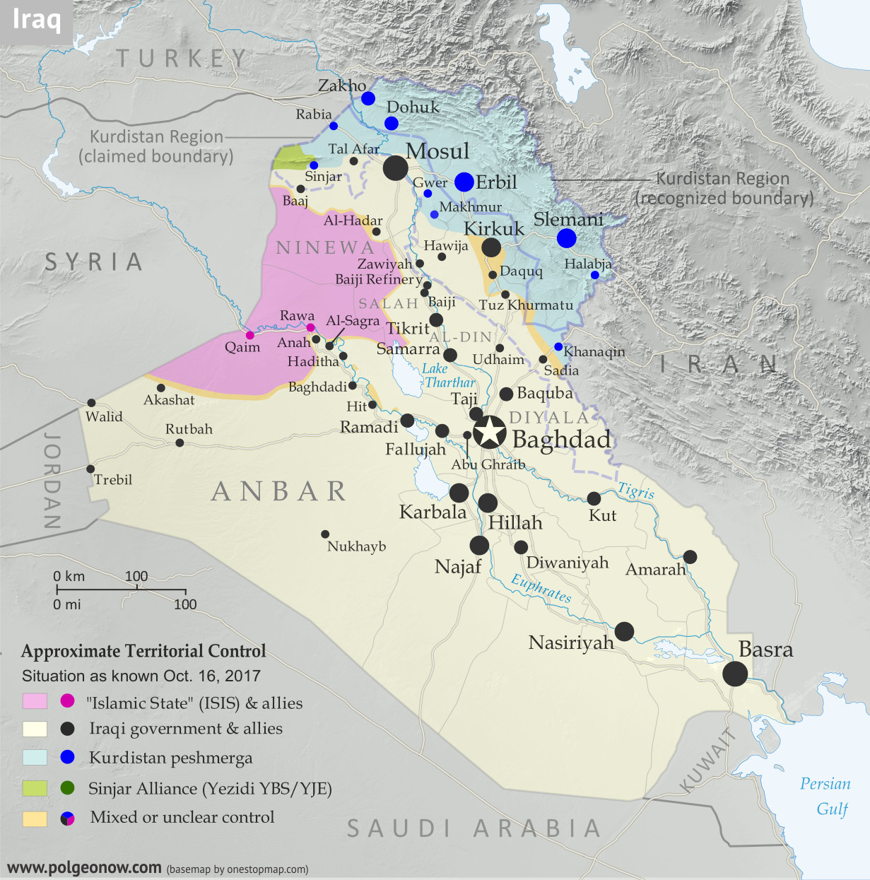
Detailed map of territorial control in Iraq as of October 16, 2017 after the recapture of Hawija and Tal Afar and government seizure of Kirkuk. including territory held by the so-called Islamic State (ISIS, ISIL), the Baghdad government, the Kurdistan Peshmerga, and the Yezidi Sinjar Alliance (YBS and YJE). Colorblind accessible.
Basemap by Koen Adams of onestopmap.com, with territorial control by Evan Centanni and Djordje Djukic. All rights reserved.
(Subscribers click here to view this article in the member area)

Timeline by Djordje Djukic

Summary of Events
Since our previous Iraq control map update in late July, there have been big changes to territorial control in Iraq, all involving expansions of control for the Iraqi military and its close allies (mainly police and Iran-backed militias): The so-called "Islamic State" (IS; formerly ISIS/ISIL) has been driven out of its Tal Afar and Hawija enclaves, and the disputed city of Kirkuk has been retaken from Kurdish forces in response to the controversial Kurdistan independence referendum. Iraqi government forces have also begun to chip away at the remaining swath of IS territory in the countryside of Anbar province, capturing the town of Anah on the road to the Syrian border.