 |
| Map by Evan Centanni, starting from public domain blank map (license: CC BY-NC-SA). |
Updates on the world's countries and borders
Wednesday, November 19, 2014
Portuguese Community Admits New Member & Observer Countries (Map)
Friday, October 31, 2014
War in Iraq: Map of Control in October 2014 (#4) (Premium)
There are newer versions of this map available. To see them, view all Iraq updates.

Research by Djordje Djukic and Evan Centanni
PolGeoNow presents our latest update on territorial control in Iraq, which is still split three ways between the Baghdad government, the Kurdistan Regional Government, and the Islamic State (ISIS). This report covers a number of important changes to territorial control since our last Iraq map update in August.
This map and article are exclusive premium content, available only to paid members or for individual purchase. Buy now (US$9.99)
Premium map includes:
MEMBERS CLICK HERE TO PROCEED TO ARTICLE AND MAP
NOT A MEMBER YET? SUBSCRIBE NOW!

Download PDF Buy now |
PolGeoNow presents our latest update on territorial control in Iraq, which is still split three ways between the Baghdad government, the Kurdistan Regional Government, and the Islamic State (ISIS). This report covers a number of important changes to territorial control since our last Iraq map update in August.
This map and article are exclusive premium content, available only to paid members or for individual purchase. Buy now (US$9.99)
Premium map includes:
- Up-to-date map of current territorial control in Iraq, color-coded for the Iraqi government, ISIS/Islamic State extremists, and Kurdish Peshmerga forces
- Detailed indication of city-by-city control, highlighting key towns relevant to current events
- Includes recent areas of fighting including Hit, Jurf al-Sakar, Mosul Dam, Jalula, and more
- Timeline-style report on changes to the situation since August, with links to sources
MEMBERS CLICK HERE TO PROCEED TO ARTICLE AND MAP
NOT A MEMBER YET? SUBSCRIBE NOW!
Friday, October 24, 2014
Map Update: Kosovo Now Recognized by Every Country in Oceania (107/193 UN members)
Premium members click here to view this article in the ad-free members area. Not a member yet? Subscribe now!
 |
| Countries recognizing the Republic of Kosovo in green, highlighting recent additions. Disputed recognitions in yellow. Kosovo in magenta. Map by Evan Centanni, modified from public domain graphic (source). |
Tuesday, October 14, 2014
Map: "Eurasian Union" Gets New Member
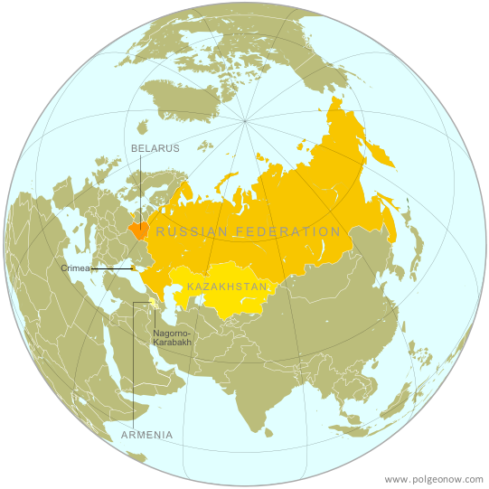 |
| The Eurasian Economic Union's four member countries, plus disputed territories that might be officially or unofficially included. Map by Evan Centanni, starting from this map by Keverich2. License: CC BY-SA |
Monday, October 6, 2014
Syria Civil War Map: October 2014 (#15) (Premium)
There are newer versions of this map available. To see them, view all Syria updates.

Our territorial control map of the Syrian Civil War has been updated for October, showing changes to the situation since the previous Syria map report in September. The map and accompanying timeline show the Islamic State's advance against Kurdish-held Kobani, as well as other developments from the past few weeks.
This map and article are exclusive premium content, available to paid subscribers or for individual purchase.
Buy now (US$9.99)
Premium map includes:
MEMBERS CLICK HERE TO PROCEED TO ARTICLE AND MAP
NOT A MEMBER YET? SUBSCRIBE NOW!

Download PDF buy |
This map and article are exclusive premium content, available to paid subscribers or for individual purchase.
Buy now (US$9.99)
Premium map includes:
- Up-to-date map of current territorial control in Syria, color-coded for the Assad government, rebel groups, Islamic State (ISIS) extremists, and Kurdish self-protection forces
- Detailed indication of city-by-city control, highlighting key towns relevant to current events
- Recent areas of fighting, including Kobani (Ayn al-Arab), Deir al-Adas, and others
- Timeline of events since mid-September, with focus on changes to territorial control
MEMBERS CLICK HERE TO PROCEED TO ARTICLE AND MAP
NOT A MEMBER YET? SUBSCRIBE NOW!
Subscribe to:
Posts (Atom)